BLUE

Aaah Friday Night Lights 😍😍😍 Tu aimeras peut être Parenthood (série "familiale") par le même créateur du coup.

0
Jlifeofahunter.bsky.social

Friday night, I went to bed understanding that the river would continue to rise overnight but that I would remain safe and dry. I checked in with folks I knew on lower ground and they were safe. The next morning, I saw an alert for a dam about 30 miles upriver. AEP had evacuated for safety reasons.

1
SWpopelizbet.bsky.social

on Friday one of the experienced attorneys took me and the other newb doing child support enforcement (which we don't get PSLF for as it's conteacted out) and every single one of us at the table had had to leave public interest permanently or temporarily, all with a DV focus.

0
ASalasdairstuart.com

It's my birthday this Friday! If you enjoy the work I do, and you're able, then I have a wish list full of the exact nonsense I love. www.amazon.co.uk/hz/wishlist/...

Check out my list on Amazon

0
AFcae.nws-bot.us

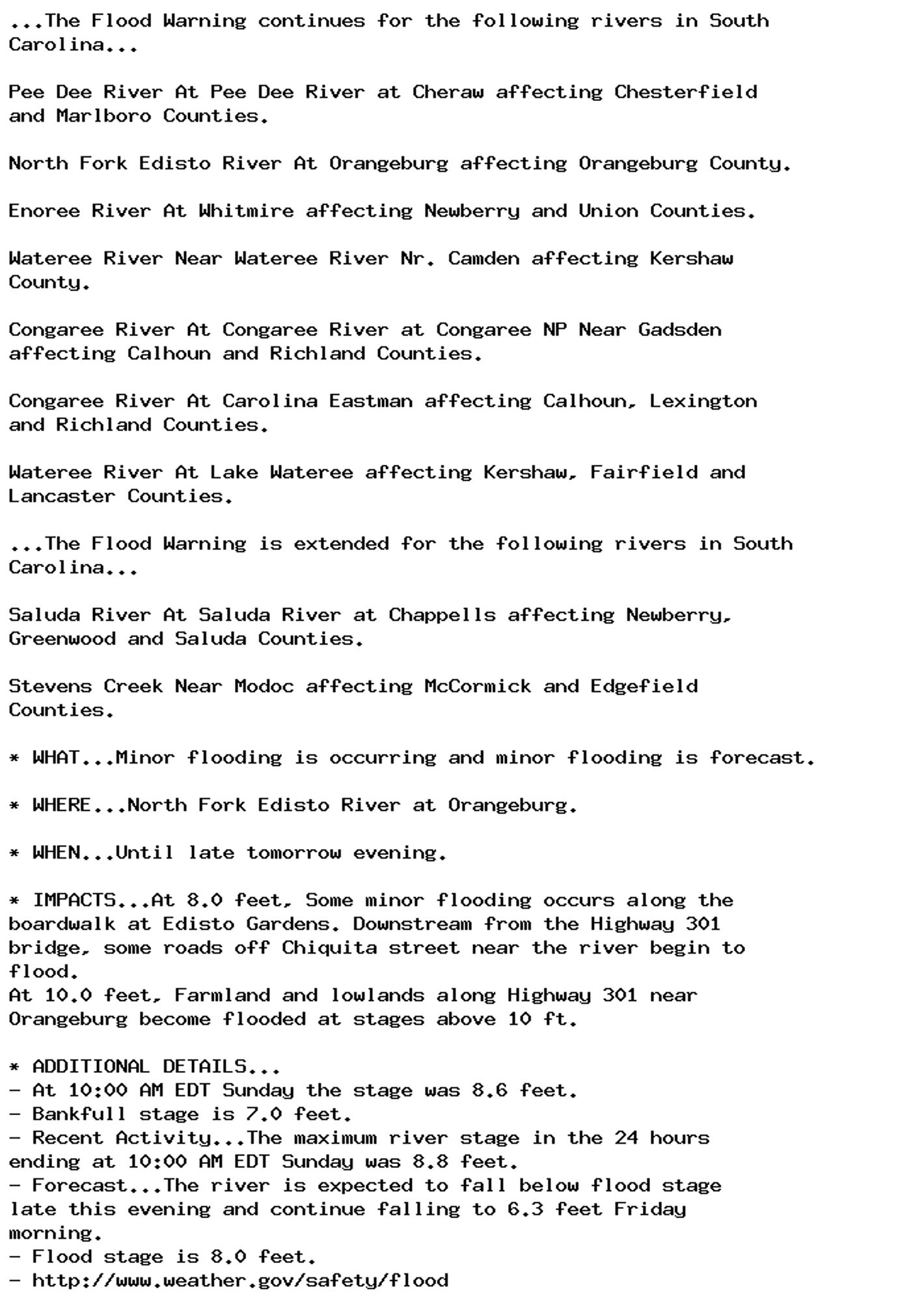
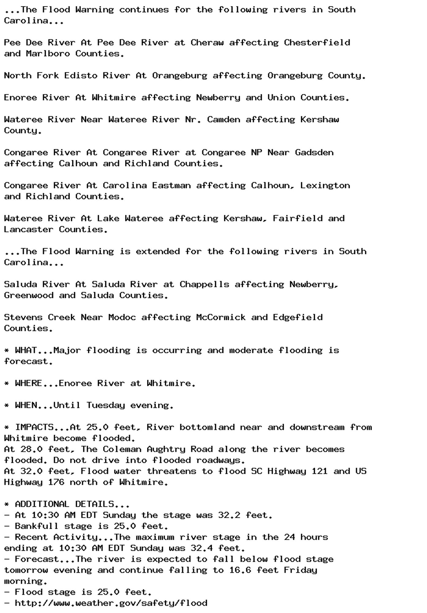
Flood Warning issued September 29 at 11:03AM EDT until October 3 at 5:22AM EDT by NWS Columbia SC Additional Details Here.

...The Flood Warning continues for the following rivers in South
Carolina...

Pee Dee River At Pee Dee River at Cheraw affecting Chesterfield
and Marlboro Counties.

North Fork Edisto River At Orangeburg affecting Orangeburg County.

Enoree River At Whitmire affecting Newberry and Union Counties.

Wateree River Near Wateree River Nr. Camden affecting Kershaw
County.

Congaree River At Congaree River at Congaree NP Near Gadsden
affecting Calhoun and Richland Counties.

Congaree River At Carolina Eastman affecting Calhoun, Lexington
and Richland Counties.

Wateree River At Lake Wateree affecting Kershaw, Fairfield and
Lancaster Counties.

...The Flood Warning is extended for the following rivers in South
Carolina...

Saluda River At Saluda River at Chappells affecting Newberry,
Greenwood and Saluda Counties.

Stevens Creek Near Modoc affecting McCormick and Edgefield
Counties.

* WHAT...Moderate flooding is occurring and moderate flooding is
forecast.

* WHERE...Saluda River at Saluda River at Chappells.

* WHEN...Until early Thursday morning.

* IMPACTS...At 14.0 feet, Lowlands around and downstream from
Chappells become flooded. Cattle grazing river bottomland should
be moved to higher ground.
At 16.0 feet, Extensive farmland and river bottomland around and
downstream from Chappells become flooded.
At 18.0 feet, The Saluda River Campground including the Campground
Store downstream from Chappells becomes flooded. Campers should
move to higher ground.
At 21.0 feet, Extensive flooding occurs. Farmland and river
bottomland around and downstream from Chappells become flooded.
Much of the Saluda River Campground downstream from Chappells
become flooded.
At 26.0 feet, Flood water threatens SC Highway 34 one mile
southwest of Chappells and SC Highway 39 a quarter mile south of
Chappells.

* ADDITIONAL DETAILS...
- At 10:15 AM EDT Sunday the stage was 25.5 feet.
- Bankfull stage is 14.0 feet.
- Recent Activity...The maximum river stage in the 24 hours
ending at 10:15 AM EDT Sunday was 26.9 feet.
- Forecast...The river is expected to fall below flood stage
early Wednesday morning and continue falling to 7.9 feet
Friday morning.
- Flood stage is 14.0 feet.
- http://www.weather.gov/safety/flood
0
AFcae.nws-bot.us

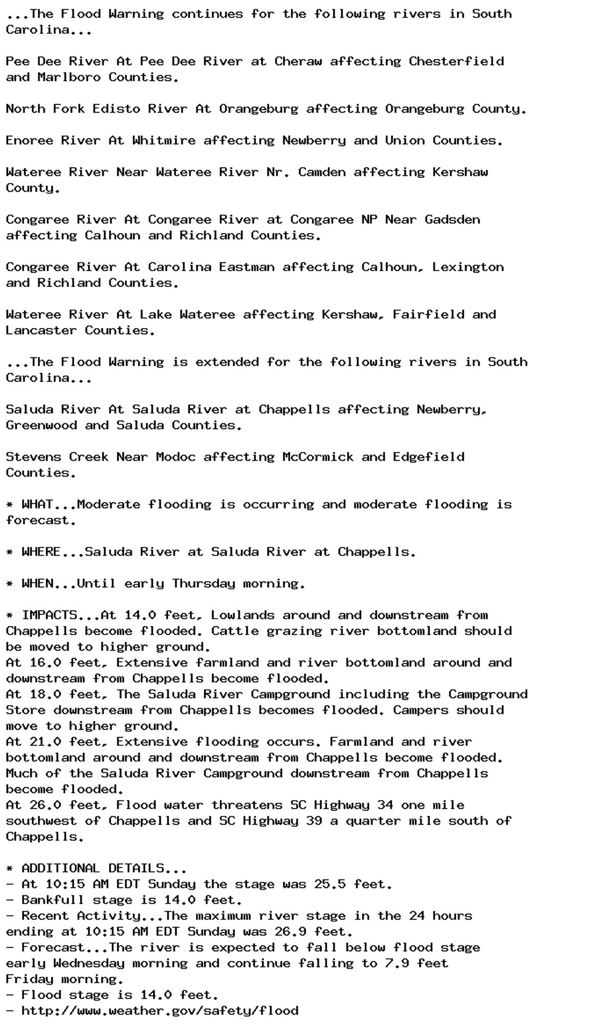
Flood Warning issued September 29 at 11:03AM EDT until September 30 at 9:30PM EDT by NWS Columbia SC Additional Details Here.

...The Flood Warning continues for the following rivers in South
Carolina...

Pee Dee River At Pee Dee River at Cheraw affecting Chesterfield
and Marlboro Counties.

North Fork Edisto River At Orangeburg affecting Orangeburg County.

Enoree River At Whitmire affecting Newberry and Union Counties.

Wateree River Near Wateree River Nr. Camden affecting Kershaw
County.

Congaree River At Congaree River at Congaree NP Near Gadsden
affecting Calhoun and Richland Counties.

Congaree River At Carolina Eastman affecting Calhoun, Lexington
and Richland Counties.

Wateree River At Lake Wateree affecting Kershaw, Fairfield and
Lancaster Counties.

...The Flood Warning is extended for the following rivers in South
Carolina...

Saluda River At Saluda River at Chappells affecting Newberry,
Greenwood and Saluda Counties.

Stevens Creek Near Modoc affecting McCormick and Edgefield
Counties.

* WHAT...Minor flooding is occurring and minor flooding is forecast.

* WHERE...North Fork Edisto River at Orangeburg.

* WHEN...Until late tomorrow evening.

* IMPACTS...At 8.0 feet, Some minor flooding occurs along the
boardwalk at Edisto Gardens. Downstream from the Highway 301
bridge, some roads off Chiquita street near the river begin to
flood.
At 10.0 feet, Farmland and lowlands along Highway 301 near
Orangeburg become flooded at stages above 10 ft.

* ADDITIONAL DETAILS...
- At 10:00 AM EDT Sunday the stage was 8.6 feet.
- Bankfull stage is 7.0 feet.
- Recent Activity...The maximum river stage in the 24 hours
ending at 10:00 AM EDT Sunday was 8.8 feet.
- Forecast...The river is expected to fall below flood stage
late this evening and continue falling to 6.3 feet Friday
morning.
- Flood stage is 8.0 feet.
- http://www.weather.gov/safety/flood
0
NFnews-feed.bsky.social

@Jerusalem_Post: Australian news anchor Erin Molan has recently come under fire for her support of Israel after saying last week on Friday during a news broadcast on Sky News Australia.

0
AFcae.nws-bot.us

Flood Warning issued September 29 at 11:03AM EDT until October 1 at 7:34PM EDT by NWS Columbia SC Additional Details Here.

...The Flood Warning continues for the following rivers in South
Carolina...

Pee Dee River At Pee Dee River at Cheraw affecting Chesterfield
and Marlboro Counties.

North Fork Edisto River At Orangeburg affecting Orangeburg County.

Enoree River At Whitmire affecting Newberry and Union Counties.

Wateree River Near Wateree River Nr. Camden affecting Kershaw
County.

Congaree River At Congaree River at Congaree NP Near Gadsden
affecting Calhoun and Richland Counties.

Congaree River At Carolina Eastman affecting Calhoun, Lexington
and Richland Counties.

Wateree River At Lake Wateree affecting Kershaw, Fairfield and
Lancaster Counties.

...The Flood Warning is extended for the following rivers in South
Carolina...

Saluda River At Saluda River at Chappells affecting Newberry,
Greenwood and Saluda Counties.

Stevens Creek Near Modoc affecting McCormick and Edgefield
Counties.

* WHAT...Major flooding is occurring and moderate flooding is
forecast.

* WHERE...Enoree River at Whitmire.

* WHEN...Until Tuesday evening.

* IMPACTS...At 25.0 feet, River bottomland near and downstream from
Whitmire become flooded.
At 28.0 feet, The Coleman Aughtry Road along the river becomes
flooded. Do not drive into flooded roadways.
At 32.0 feet, Flood water threatens to flood SC Highway 121 and US
Highway 176 north of Whitmire.

* ADDITIONAL DETAILS...
- At 10:30 AM EDT Sunday the stage was 32.2 feet.
- Bankfull stage is 25.0 feet.
- Recent Activity...The maximum river stage in the 24 hours
ending at 10:30 AM EDT Sunday was 32.4 feet.
- Forecast...The river is expected to fall below flood stage
tomorrow evening and continue falling to 16.6 feet Friday
morning.
- Flood stage is 25.0 feet.
- http://www.weather.gov/safety/flood
0
AFilm.nws-bot.us

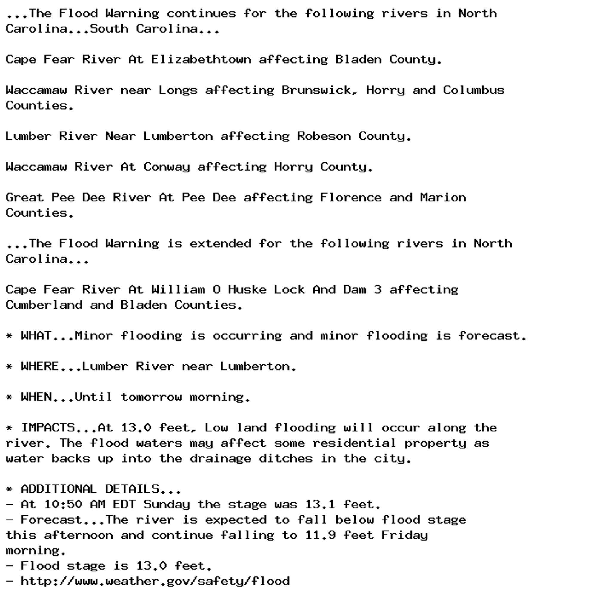
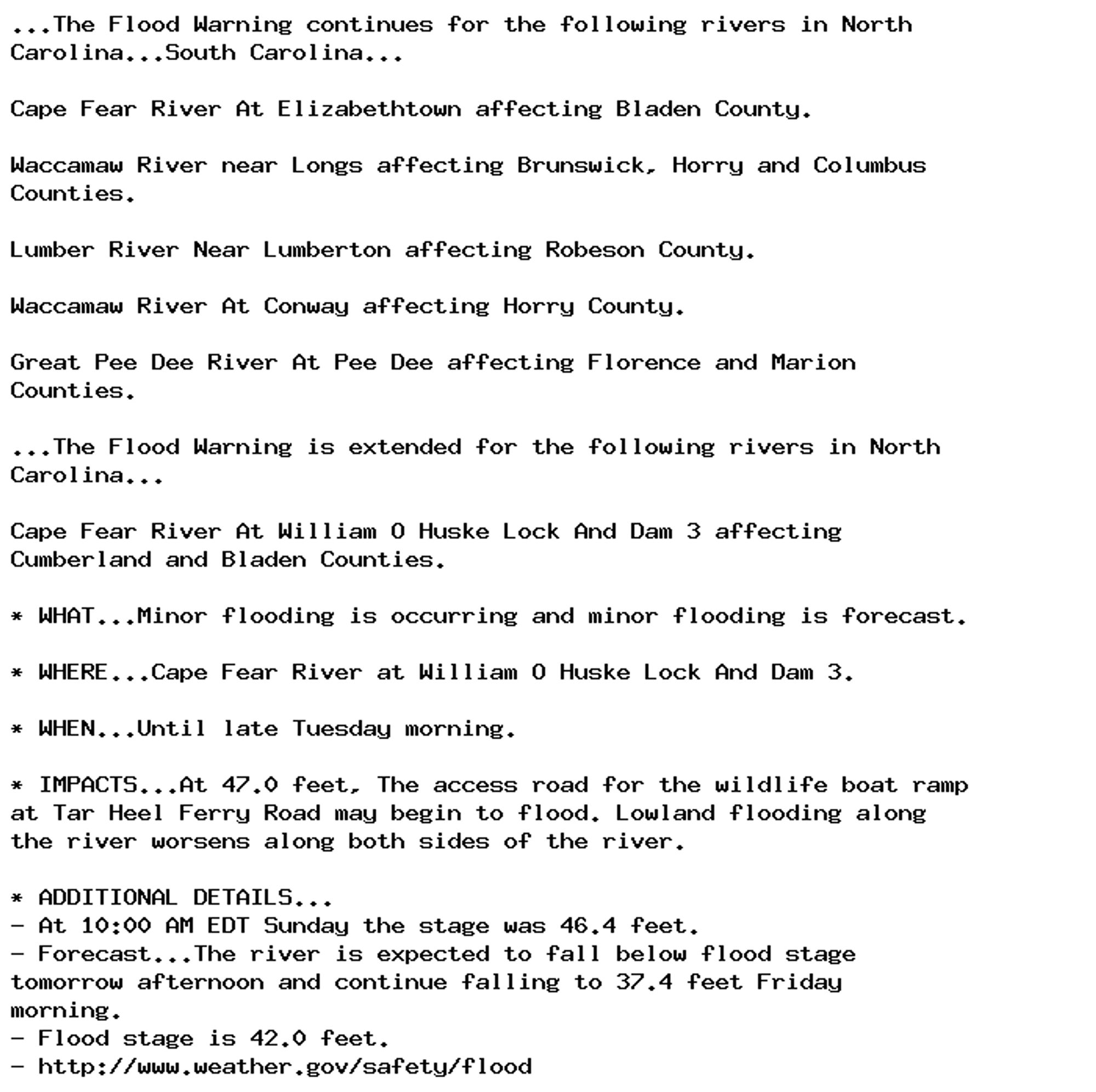
Flood Warning issued September 29 at 11:04AM EDT until October 1 at 9:42AM EDT by NWS Wilmington NC Additional Details Here.

...The Flood Warning continues for the following rivers in North
Carolina...South Carolina...

Cape Fear River At Elizabethtown affecting Bladen County.

Waccamaw River near Longs affecting Brunswick, Horry and Columbus
Counties.

Lumber River Near Lumberton affecting Robeson County.

Waccamaw River At Conway affecting Horry County.

Great Pee Dee River At Pee Dee affecting Florence and Marion
Counties.

...The Flood Warning is extended for the following rivers in North
Carolina...

Cape Fear River At William O Huske Lock And Dam 3 affecting
Cumberland and Bladen Counties.

* WHAT...Minor flooding is occurring and minor flooding is forecast.

* WHERE...Cape Fear River at William O Huske Lock And Dam 3.

* WHEN...Until late Tuesday morning.

* IMPACTS...At 47.0 feet, The access road for the wildlife boat ramp
at Tar Heel Ferry Road may begin to flood. Lowland flooding along
the river worsens along both sides of the river.

* ADDITIONAL DETAILS...
- At 10:00 AM EDT Sunday the stage was 46.4 feet.
- Forecast...The river is expected to fall below flood stage
tomorrow afternoon and continue falling to 37.4 feet Friday
morning.
- Flood stage is 42.0 feet.
- http://www.weather.gov/safety/flood
0
AFilm.nws-bot.us

Flood Warning issued September 29 at 11:04AM EDT until September 30 at 8:00AM EDT by NWS Wilmington NC Additional Details Here.

...The Flood Warning continues for the following rivers in North
Carolina...South Carolina...

Cape Fear River At Elizabethtown affecting Bladen County.

Waccamaw River near Longs affecting Brunswick, Horry and Columbus
Counties.

Lumber River Near Lumberton affecting Robeson County.

Waccamaw River At Conway affecting Horry County.

Great Pee Dee River At Pee Dee affecting Florence and Marion
Counties.

...The Flood Warning is extended for the following rivers in North
Carolina...

Cape Fear River At William O Huske Lock And Dam 3 affecting
Cumberland and Bladen Counties.

* WHAT...Minor flooding is occurring and minor flooding is forecast.

* WHERE...Lumber River near Lumberton.

* WHEN...Until tomorrow morning.

* IMPACTS...At 13.0 feet, Low land flooding will occur along the
river. The flood waters may affect some residential property as
water backs up into the drainage ditches in the city.

* ADDITIONAL DETAILS...
- At 10:50 AM EDT Sunday the stage was 13.1 feet.
- Forecast...The river is expected to fall below flood stage
this afternoon and continue falling to 11.9 feet Friday
morning.
- Flood stage is 13.0 feet.
- http://www.weather.gov/safety/flood
0