BLUE
RCravenmcampbell.bsky.social

Lots of the deaths in SC are from trees falling on people’s houses. When you have a foot of rain and high winds, there’s not much you can do except living somewhere without trees.

0
RSrebeccapscales.bsky.social

I am not sure people realize how bad things are in parts of the south. Western NC is in terrible shape, but fully half of SC is w/o power & officials have turned off water in Augusta for 24-48 hours, right across the river from where my mom & I are. It’s also going to be in the upper 80s this week.

0
AFcae.nws-bot.us

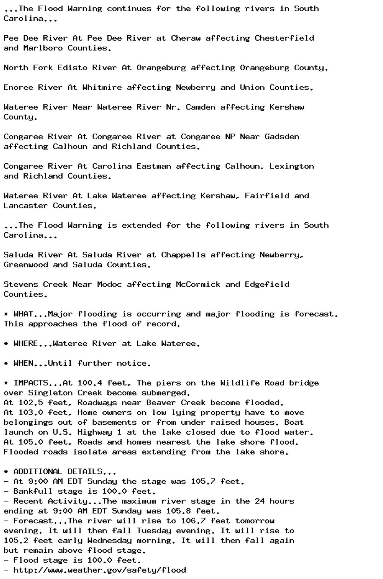
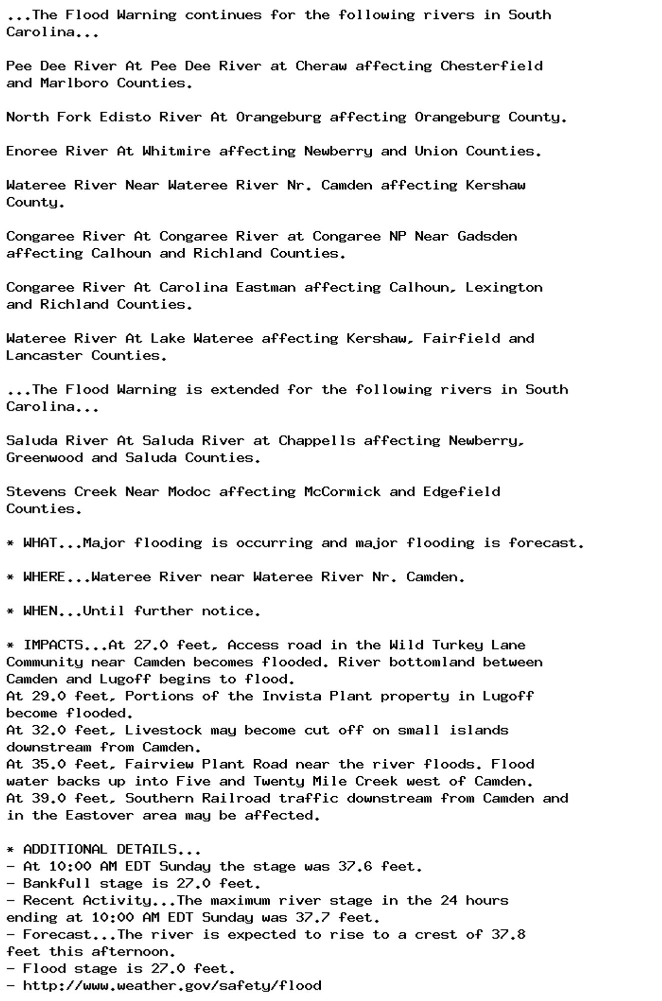
Flood Warning issued September 29 at 11:03AM EDT until October 3 at 5:22AM EDT by NWS Columbia SC Additional Details Here.

...The Flood Warning continues for the following rivers in South
Carolina...

Pee Dee River At Pee Dee River at Cheraw affecting Chesterfield
and Marlboro Counties.

North Fork Edisto River At Orangeburg affecting Orangeburg County.

Enoree River At Whitmire affecting Newberry and Union Counties.

Wateree River Near Wateree River Nr. Camden affecting Kershaw
County.

Congaree River At Congaree River at Congaree NP Near Gadsden
affecting Calhoun and Richland Counties.

Congaree River At Carolina Eastman affecting Calhoun, Lexington
and Richland Counties.

Wateree River At Lake Wateree affecting Kershaw, Fairfield and
Lancaster Counties.

...The Flood Warning is extended for the following rivers in South
Carolina...

Saluda River At Saluda River at Chappells affecting Newberry,
Greenwood and Saluda Counties.

Stevens Creek Near Modoc affecting McCormick and Edgefield
Counties.

* WHAT...Moderate flooding is occurring and moderate flooding is
forecast.

* WHERE...Saluda River at Saluda River at Chappells.

* WHEN...Until early Thursday morning.

* IMPACTS...At 14.0 feet, Lowlands around and downstream from
Chappells become flooded. Cattle grazing river bottomland should
be moved to higher ground.
At 16.0 feet, Extensive farmland and river bottomland around and
downstream from Chappells become flooded.
At 18.0 feet, The Saluda River Campground including the Campground
Store downstream from Chappells becomes flooded. Campers should
move to higher ground.
At 21.0 feet, Extensive flooding occurs. Farmland and river
bottomland around and downstream from Chappells become flooded.
Much of the Saluda River Campground downstream from Chappells
become flooded.
At 26.0 feet, Flood water threatens SC Highway 34 one mile
southwest of Chappells and SC Highway 39 a quarter mile south of
Chappells.

* ADDITIONAL DETAILS...
- At 10:15 AM EDT Sunday the stage was 25.5 feet.
- Bankfull stage is 14.0 feet.
- Recent Activity...The maximum river stage in the 24 hours
ending at 10:15 AM EDT Sunday was 26.9 feet.
- Forecast...The river is expected to fall below flood stage
early Wednesday morning and continue falling to 7.9 feet
Friday morning.
- Flood stage is 14.0 feet.
- http://www.weather.gov/safety/flood
0
AFcae.nws-bot.us

Flood Warning issued September 29 at 11:03AM EDT by NWS Columbia SC Additional Details Here.

...The Flood Warning continues for the following rivers in South
Carolina...

Pee Dee River At Pee Dee River at Cheraw affecting Chesterfield
and Marlboro Counties.

North Fork Edisto River At Orangeburg affecting Orangeburg County.

Enoree River At Whitmire affecting Newberry and Union Counties.

Wateree River Near Wateree River Nr. Camden affecting Kershaw
County.

Congaree River At Congaree River at Congaree NP Near Gadsden
affecting Calhoun and Richland Counties.

Congaree River At Carolina Eastman affecting Calhoun, Lexington
and Richland Counties.

Wateree River At Lake Wateree affecting Kershaw, Fairfield and
Lancaster Counties.

...The Flood Warning is extended for the following rivers in South
Carolina...

Saluda River At Saluda River at Chappells affecting Newberry,
Greenwood and Saluda Counties.

Stevens Creek Near Modoc affecting McCormick and Edgefield
Counties.

* WHAT...Major flooding is occurring and major flooding is forecast.
This approaches the flood of record.

* WHERE...Wateree River at Lake Wateree.

* WHEN...Until further notice.

* IMPACTS...At 100.4 feet, The piers on the Wildlife Road bridge
over Singleton Creek become submerged.
At 102.5 feet, Roadways near Beaver Creek become flooded.
At 103.0 feet, Home owners on low lying property have to move
belongings out of basements or from under raised houses. Boat
launch on U.S. Highway 1 at the lake closed due to flood water.
At 105.0 feet, Roads and homes nearest the lake shore flood.
Flooded roads isolate areas extending from the lake shore.

* ADDITIONAL DETAILS...
- At 9:00 AM EDT Sunday the stage was 105.7 feet.
- Bankfull stage is 100.0 feet.
- Recent Activity...The maximum river stage in the 24 hours
ending at 9:00 AM EDT Sunday was 105.8 feet.
- Forecast...The river will rise to 106.7 feet tomorrow
evening. It will then fall Tuesday evening. It will rise to
105.2 feet early Wednesday morning. It will then fall again
but remain above flood stage.
- Flood stage is 100.0 feet.
- http://www.weather.gov/safety/flood
0
AFcae.nws-bot.us

Flood Warning issued September 29 at 11:03AM EDT by NWS Columbia SC Additional Details Here.

...The Flood Warning continues for the following rivers in South
Carolina...

Pee Dee River At Pee Dee River at Cheraw affecting Chesterfield
and Marlboro Counties.

North Fork Edisto River At Orangeburg affecting Orangeburg County.

Enoree River At Whitmire affecting Newberry and Union Counties.

Wateree River Near Wateree River Nr. Camden affecting Kershaw
County.

Congaree River At Congaree River at Congaree NP Near Gadsden
affecting Calhoun and Richland Counties.

Congaree River At Carolina Eastman affecting Calhoun, Lexington
and Richland Counties.

Wateree River At Lake Wateree affecting Kershaw, Fairfield and
Lancaster Counties.

...The Flood Warning is extended for the following rivers in South
Carolina...

Saluda River At Saluda River at Chappells affecting Newberry,
Greenwood and Saluda Counties.

Stevens Creek Near Modoc affecting McCormick and Edgefield
Counties.

* WHAT...Moderate flooding is occurring and major flooding is
forecast.

* WHERE...Congaree River at Carolina Eastman.

* WHEN...Until further notice.

* IMPACTS...At 115.0 feet, Flooding occurs in low lying areas of the
Carolina Eastman Facility and at the Congaree National Park.
At 119.0 feet, Extensive flooding occurs in the Congaree National
Park. Some area farmland is flooded. Minor flooding occurs at the
Carolina Eastman Facility.
At 124.0 feet, Extensive flooding occurs at the Carolina Eastman
Facility with some access roads flooded. Extensive farmland
flooding occurs in the area.
At 126.0 feet, Extensive farmland and lowland flooding will occur
south of Columbia to Lake Marion. Water reaches the top of some
dikes at the Carolina Eastman Facility.
At 127.0 feet, Portions of the Carolina Eastman facility have to
be evacuated.

* ADDITIONAL DETAILS...
- At 8:00 AM EDT Sunday the stage was 124.8 feet.
- Bankfull stage is 114.0 feet.
- Recent Activity...The maximum river stage in the 24 hours
ending at 8:00 AM EDT Sunday was 124.8 feet.
- Forecast...The river is expected to rise to a crest of 126.9
feet tomorrow evening.
- Flood stage is 115.0 feet.
- http://www.weather.gov/safety/flood
0
AFcae.nws-bot.us

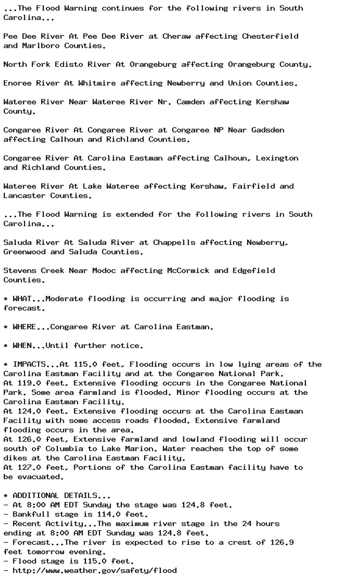
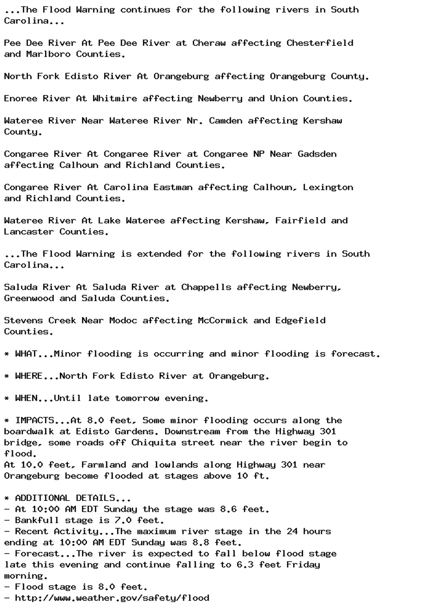
Flood Warning issued September 29 at 11:03AM EDT until October 1 at 9:48PM EDT by NWS Columbia SC Additional Details Here.

...The Flood Warning continues for the following rivers in South
Carolina...

Pee Dee River At Pee Dee River at Cheraw affecting Chesterfield
and Marlboro Counties.

North Fork Edisto River At Orangeburg affecting Orangeburg County.

Enoree River At Whitmire affecting Newberry and Union Counties.

Wateree River Near Wateree River Nr. Camden affecting Kershaw
County.

Congaree River At Congaree River at Congaree NP Near Gadsden
affecting Calhoun and Richland Counties.

Congaree River At Carolina Eastman affecting Calhoun, Lexington
and Richland Counties.

Wateree River At Lake Wateree affecting Kershaw, Fairfield and
Lancaster Counties.

...The Flood Warning is extended for the following rivers in South
Carolina...

Saluda River At Saluda River at Chappells affecting Newberry,
Greenwood and Saluda Counties.

Stevens Creek Near Modoc affecting McCormick and Edgefield
Counties.

* WHAT...Minor flooding is occurring and minor flooding is forecast.

* WHERE...Pee Dee River at Pee Dee River at Cheraw.

* WHEN...Until late Tuesday evening.

* IMPACTS...At 20.0 feet, River bottomland downstream from cheraw
will begin to flood.
At 30.0 feet, The higher bank begins to flood. Large areas of
farmland and river bottomland near Cheraw will be flooded.
Portions of Riverside Park become flooded.
At 33.0 feet, Southeast of Wallace, water spreads onto Old River
Road between Community Road and Highway 912.
At 35.0 feet, Southeast of Wallace, Old River Road between
Community Road and Highway 912 will become flooded and may need to
be closed.
At 36.0 feet, Extensive overflow of the left bank will occur and
large areas of farmland near Cheraw will be flooded. Livestock and
farm equipment should be moved to higher ground.

* ADDITIONAL DETAILS...
- At 10:15 AM EDT Sunday the stage was 33.4 feet.
- Bankfull stage is 20.0 feet.
- Recent Activity...The maximum river stage in the 24 hours
ending at 10:15 AM EDT Sunday was 33.4 feet.
- Forecast...The river is expected to rise to a crest of 34.5
feet just after midnight tonight. It will then fall below
flood stage late tomorrow evening.
- Flood stage is 30.0 feet.
- http://www.weather.gov/safety/flood
0
AFcae.nws-bot.us

Flood Warning issued September 29 at 11:03AM EDT until September 30 at 12:47PM EDT by NWS Columbia SC Additional Details Here.

...The Flood Warning continues for the following rivers in South
Carolina...

Pee Dee River At Pee Dee River at Cheraw affecting Chesterfield
and Marlboro Counties.

North Fork Edisto River At Orangeburg affecting Orangeburg County.

Enoree River At Whitmire affecting Newberry and Union Counties.

Wateree River Near Wateree River Nr. Camden affecting Kershaw
County.

Congaree River At Congaree River at Congaree NP Near Gadsden
affecting Calhoun and Richland Counties.

Congaree River At Carolina Eastman affecting Calhoun, Lexington
and Richland Counties.

Wateree River At Lake Wateree affecting Kershaw, Fairfield and
Lancaster Counties.

...The Flood Warning is extended for the following rivers in South
Carolina...

Saluda River At Saluda River at Chappells affecting Newberry,
Greenwood and Saluda Counties.

Stevens Creek Near Modoc affecting McCormick and Edgefield
Counties.

* WHAT...Minor flooding is occurring.

* WHERE...Stevens Creek near Modoc.

* WHEN...Until early tomorrow afternoon.

* IMPACTS...At 19.0 feet, Farmland along Stevens Creek above the US
Highway 23 bridge near Modoc becomes flooded.
At 26.0 feet, Low lying and flood prone areas near Martin Town
Road become flooded. Residents along Stevens Creek in the
Riverhills subdivision should take precautions to protect life and
property from flooding waters.
At 28.0 feet, The Garrett Road bridge over Stevens Creek below
Clarks Hill will flood.

* ADDITIONAL DETAILS...
- At 10:00 AM EDT Sunday the stage was 28.2 feet.
- Bankfull stage is 14.0 feet.
- Recent Activity...The maximum river stage in the 24 hours
ending at 10:00 AM EDT Sunday was 42.6 feet.
- Forecast...The river is expected to fall below flood stage
this afternoon and continue falling to 3.4 feet Thursday
evening.
- Flood stage is 19.0 feet.
- http://www.weather.gov/safety/flood
0
AFcae.nws-bot.us

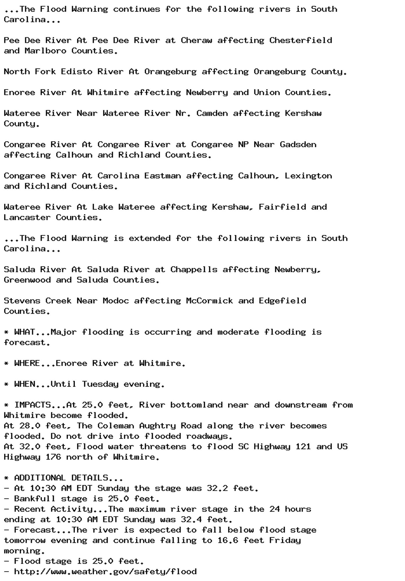
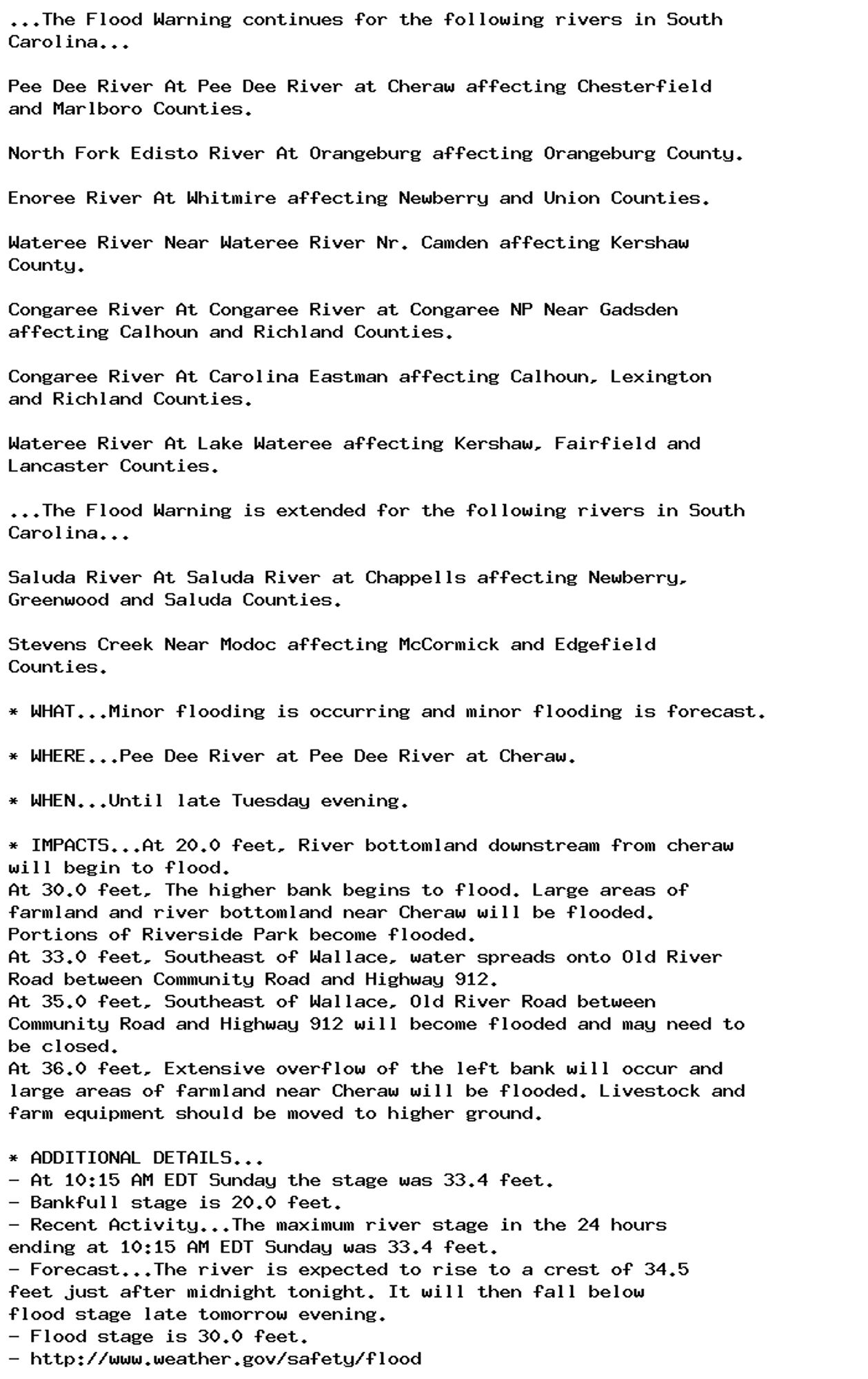
Flood Warning issued September 29 at 11:03AM EDT until September 30 at 9:30PM EDT by NWS Columbia SC Additional Details Here.

...The Flood Warning continues for the following rivers in South
Carolina...

Pee Dee River At Pee Dee River at Cheraw affecting Chesterfield
and Marlboro Counties.

North Fork Edisto River At Orangeburg affecting Orangeburg County.

Enoree River At Whitmire affecting Newberry and Union Counties.

Wateree River Near Wateree River Nr. Camden affecting Kershaw
County.

Congaree River At Congaree River at Congaree NP Near Gadsden
affecting Calhoun and Richland Counties.

Congaree River At Carolina Eastman affecting Calhoun, Lexington
and Richland Counties.

Wateree River At Lake Wateree affecting Kershaw, Fairfield and
Lancaster Counties.

...The Flood Warning is extended for the following rivers in South
Carolina...

Saluda River At Saluda River at Chappells affecting Newberry,
Greenwood and Saluda Counties.

Stevens Creek Near Modoc affecting McCormick and Edgefield
Counties.

* WHAT...Minor flooding is occurring and minor flooding is forecast.

* WHERE...North Fork Edisto River at Orangeburg.

* WHEN...Until late tomorrow evening.

* IMPACTS...At 8.0 feet, Some minor flooding occurs along the
boardwalk at Edisto Gardens. Downstream from the Highway 301
bridge, some roads off Chiquita street near the river begin to
flood.
At 10.0 feet, Farmland and lowlands along Highway 301 near
Orangeburg become flooded at stages above 10 ft.

* ADDITIONAL DETAILS...
- At 10:00 AM EDT Sunday the stage was 8.6 feet.
- Bankfull stage is 7.0 feet.
- Recent Activity...The maximum river stage in the 24 hours
ending at 10:00 AM EDT Sunday was 8.8 feet.
- Forecast...The river is expected to fall below flood stage
late this evening and continue falling to 6.3 feet Friday
morning.
- Flood stage is 8.0 feet.
- http://www.weather.gov/safety/flood
0
AFcae.nws-bot.us

Flood Warning issued September 29 at 11:03AM EDT by NWS Columbia SC Additional Details Here.

...The Flood Warning continues for the following rivers in South
Carolina...

Pee Dee River At Pee Dee River at Cheraw affecting Chesterfield
and Marlboro Counties.

North Fork Edisto River At Orangeburg affecting Orangeburg County.

Enoree River At Whitmire affecting Newberry and Union Counties.

Wateree River Near Wateree River Nr. Camden affecting Kershaw
County.

Congaree River At Congaree River at Congaree NP Near Gadsden
affecting Calhoun and Richland Counties.

Congaree River At Carolina Eastman affecting Calhoun, Lexington
and Richland Counties.

Wateree River At Lake Wateree affecting Kershaw, Fairfield and
Lancaster Counties.

...The Flood Warning is extended for the following rivers in South
Carolina...

Saluda River At Saluda River at Chappells affecting Newberry,
Greenwood and Saluda Counties.

Stevens Creek Near Modoc affecting McCormick and Edgefield
Counties.

* WHAT...Major flooding is occurring and major flooding is forecast.

* WHERE...Wateree River near Wateree River Nr. Camden.

* WHEN...Until further notice.

* IMPACTS...At 27.0 feet, Access road in the Wild Turkey Lane
Community near Camden becomes flooded. River bottomland between
Camden and Lugoff begins to flood.
At 29.0 feet, Portions of the Invista Plant property in Lugoff
become flooded.
At 32.0 feet, Livestock may become cut off on small islands
downstream from Camden.
At 35.0 feet, Fairview Plant Road near the river floods. Flood
water backs up into Five and Twenty Mile Creek west of Camden.
At 39.0 feet, Southern Railroad traffic downstream from Camden and
in the Eastover area may be affected.

* ADDITIONAL DETAILS...
- At 10:00 AM EDT Sunday the stage was 37.6 feet.
- Bankfull stage is 27.0 feet.
- Recent Activity...The maximum river stage in the 24 hours
ending at 10:00 AM EDT Sunday was 37.7 feet.
- Forecast...The river is expected to rise to a crest of 37.8
feet this afternoon.
- Flood stage is 27.0 feet.
- http://www.weather.gov/safety/flood
0
AFcae.nws-bot.us

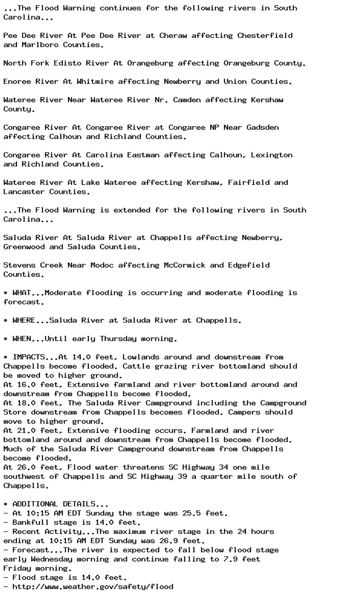
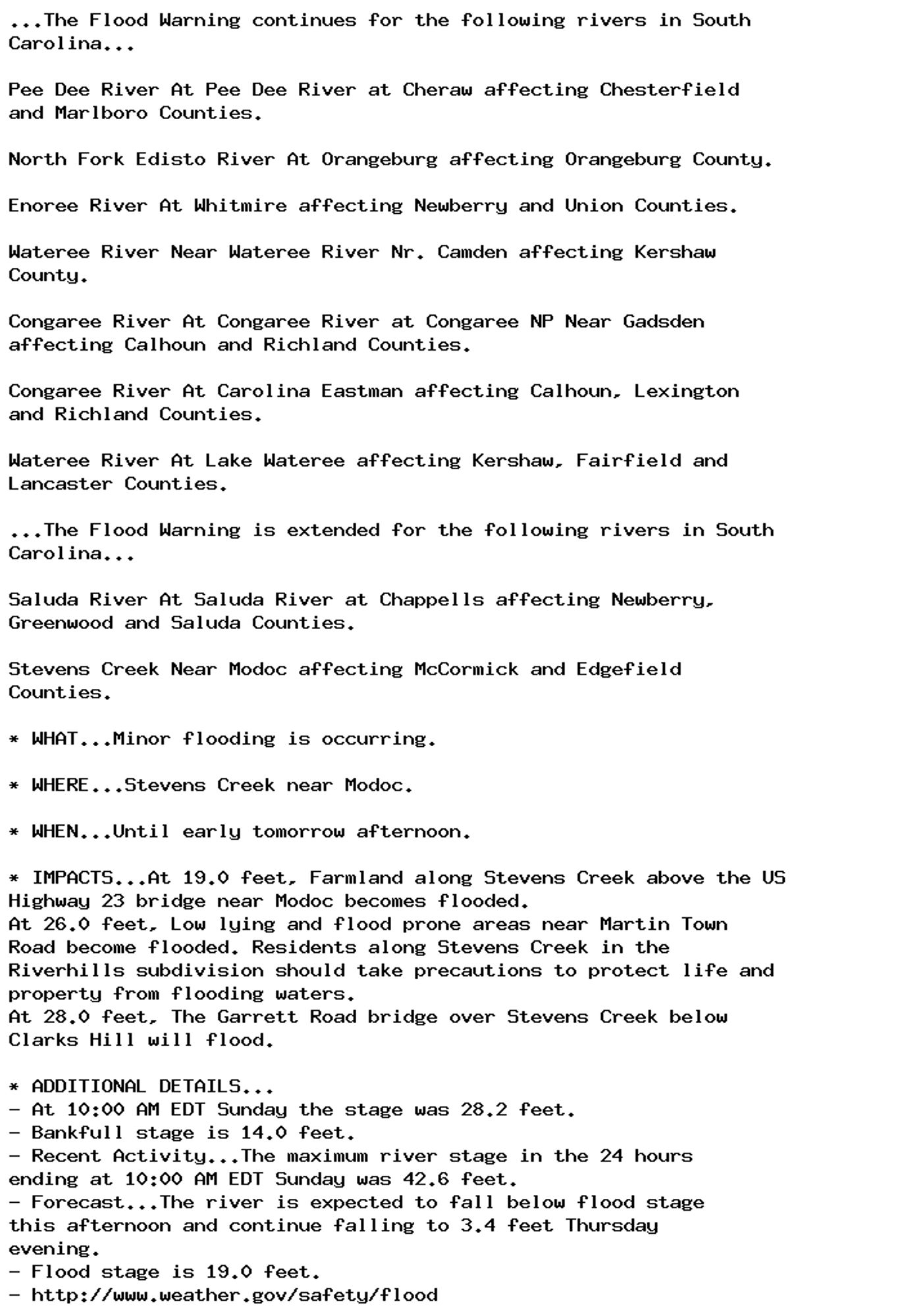
Flood Warning issued September 29 at 11:03AM EDT until October 1 at 7:34PM EDT by NWS Columbia SC Additional Details Here.

...The Flood Warning continues for the following rivers in South
Carolina...

Pee Dee River At Pee Dee River at Cheraw affecting Chesterfield
and Marlboro Counties.

North Fork Edisto River At Orangeburg affecting Orangeburg County.

Enoree River At Whitmire affecting Newberry and Union Counties.

Wateree River Near Wateree River Nr. Camden affecting Kershaw
County.

Congaree River At Congaree River at Congaree NP Near Gadsden
affecting Calhoun and Richland Counties.

Congaree River At Carolina Eastman affecting Calhoun, Lexington
and Richland Counties.

Wateree River At Lake Wateree affecting Kershaw, Fairfield and
Lancaster Counties.

...The Flood Warning is extended for the following rivers in South
Carolina...

Saluda River At Saluda River at Chappells affecting Newberry,
Greenwood and Saluda Counties.

Stevens Creek Near Modoc affecting McCormick and Edgefield
Counties.

* WHAT...Major flooding is occurring and moderate flooding is
forecast.

* WHERE...Enoree River at Whitmire.

* WHEN...Until Tuesday evening.

* IMPACTS...At 25.0 feet, River bottomland near and downstream from
Whitmire become flooded.
At 28.0 feet, The Coleman Aughtry Road along the river becomes
flooded. Do not drive into flooded roadways.
At 32.0 feet, Flood water threatens to flood SC Highway 121 and US
Highway 176 north of Whitmire.

* ADDITIONAL DETAILS...
- At 10:30 AM EDT Sunday the stage was 32.2 feet.
- Bankfull stage is 25.0 feet.
- Recent Activity...The maximum river stage in the 24 hours
ending at 10:30 AM EDT Sunday was 32.4 feet.
- Forecast...The river is expected to fall below flood stage
tomorrow evening and continue falling to 16.6 feet Friday
morning.
- Flood stage is 25.0 feet.
- http://www.weather.gov/safety/flood
0