BLUE
AF
Alerts from NWS Baltimore MD/Washington DC (UNOFFICIAL)
@was.nws-bot.us
Unofficial bot sharing NWS alerts for the Baltimore MD/Washington DC area. This account is not monitored. Contact @wandrme.paxex.aero if needed.
950 followers1 following92 posts
AFwas.nws-bot.us

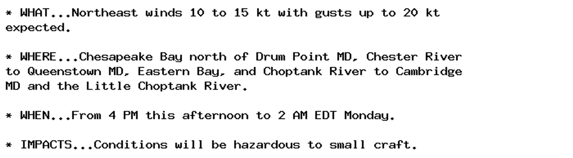
Small Craft Advisory issued September 29 at 12:02PM EDT until September 30 at 2:00AM EDT by NWS Baltimore MD/Washington DC Additional Details Here.

* WHAT...Northeast winds 10 to 15 kt with gusts up to 20 kt
expected.

* WHERE...Chesapeake Bay north of Drum Point MD, Chester River
to Queenstown MD, Eastern Bay, and Choptank River to Cambridge
MD and the Little Choptank River.

* WHEN...From 4 PM this afternoon to 2 AM EDT Monday.

* IMPACTS...Conditions will be hazardous to small craft.
0
AFwas.nws-bot.us

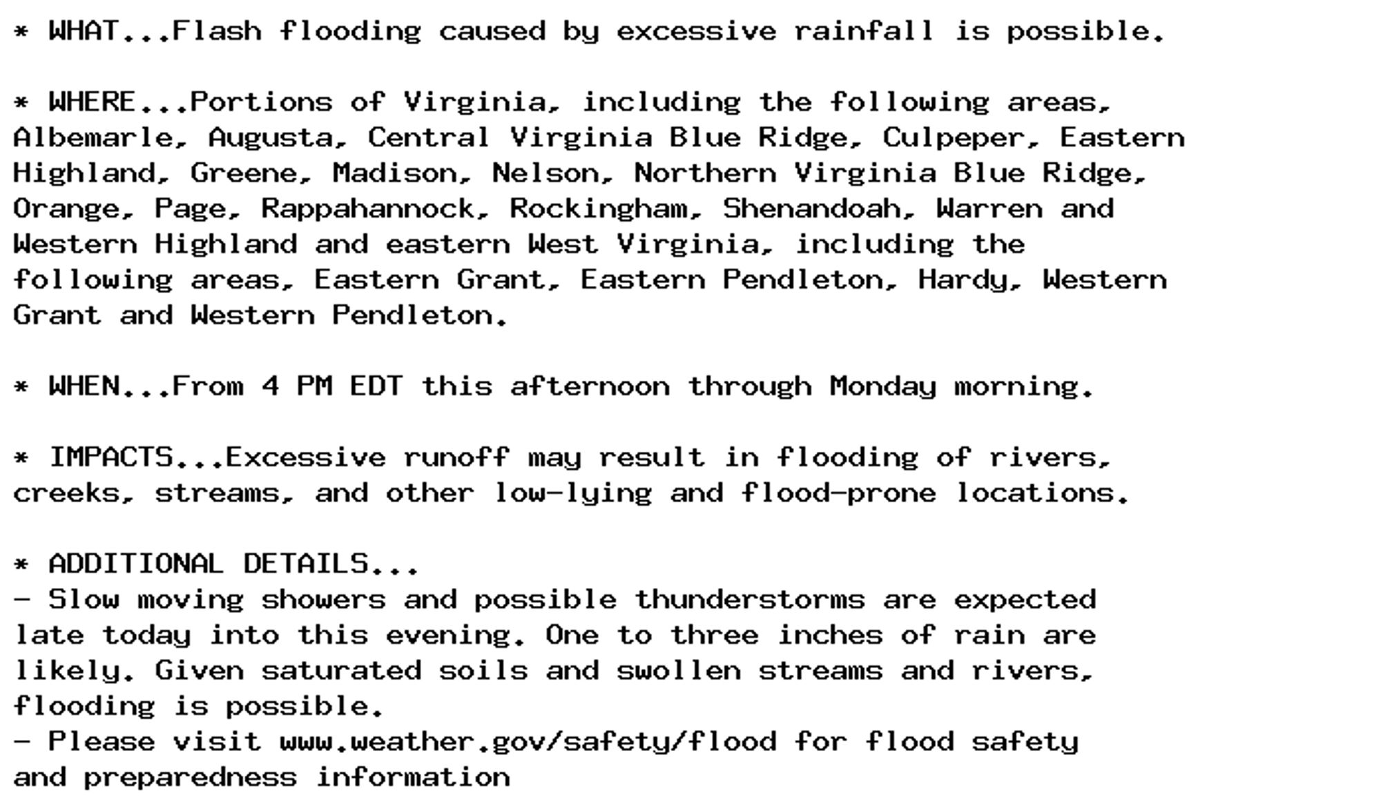
Flood Watch issued September 29 at 11:25AM EDT until September 30 at 8:00AM EDT by NWS Baltimore MD/Washington DC Additional Details Here.

...The National Weather Service in Baltimore MD/Washington DC has
issued a Flood Watch for the following rivers in Virginia...

South River near Waynesboro affecting Augusta County.

* WHAT...If higher amounts on the Blue Ridge are realized, flooding
of the South River could result.

* WHERE...South River near Waynesboro.

* WHEN...From this evening to tomorrow morning.

* IMPACTS...At 9.0 feet, Low portions of Meadowbrook Road and Arch
Avenue begin to flood.

* ADDITIONAL DETAILS...
- At 10:15 AM EDT Sunday the stage was 6.7 feet, or 2.8 feet
below flood stage.
- Forecast...Flood stage may be reached based on the latest
forecast information.
- Flood stage is 9.5 feet.
- Please visit www.weather.gov/safety/flood for flood safety
and preparedness information
0
AFwas.nws-bot.us

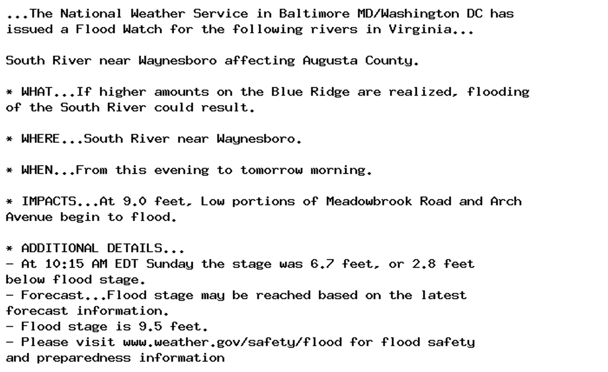
Flood Watch issued September 29 at 10:22AM EDT until September 30 at 7:00AM EDT by NWS Baltimore MD/Washington DC Additional Details Here.

* WHAT...Flash flooding caused by excessive rainfall is possible.

* WHERE...Portions of Virginia, including the following areas,
Albemarle, Augusta, Central Virginia Blue Ridge, Culpeper, Eastern
Highland, Greene, Madison, Nelson, Northern Virginia Blue Ridge,
Orange, Page, Rappahannock, Rockingham, Shenandoah, Warren and
Western Highland and eastern West Virginia, including the
following areas, Eastern Grant, Eastern Pendleton, Hardy, Western
Grant and Western Pendleton.

* WHEN...From 4 PM EDT this afternoon through Monday morning.

* IMPACTS...Excessive runoff may result in flooding of rivers,
creeks, streams, and other low-lying and flood-prone locations.

* ADDITIONAL DETAILS...
- Slow moving showers and possible thunderstorms are expected
late today into this evening. One to three inches of rain are
likely. Given saturated soils and swollen streams and rivers,
flooding is possible.
- Please visit www.weather.gov/safety/flood for flood safety
and preparedness information
0
AFwas.nws-bot.us

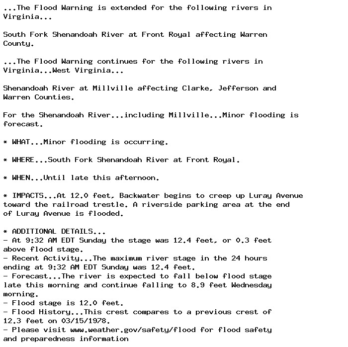
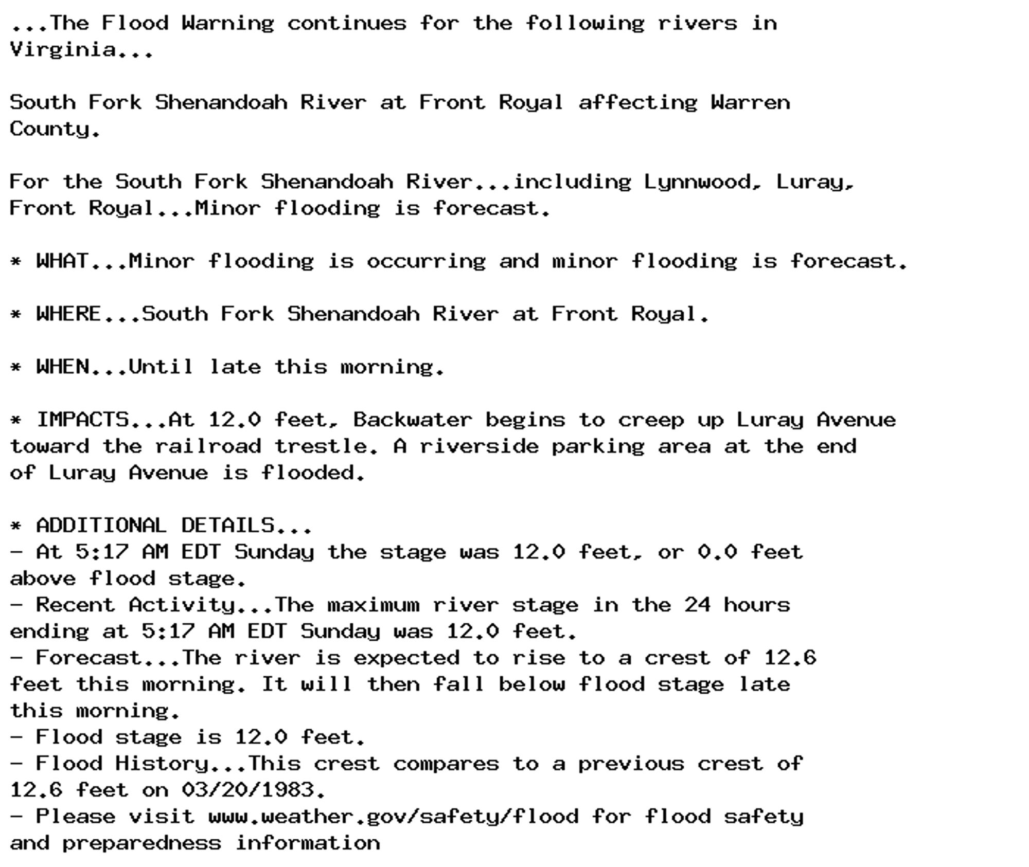
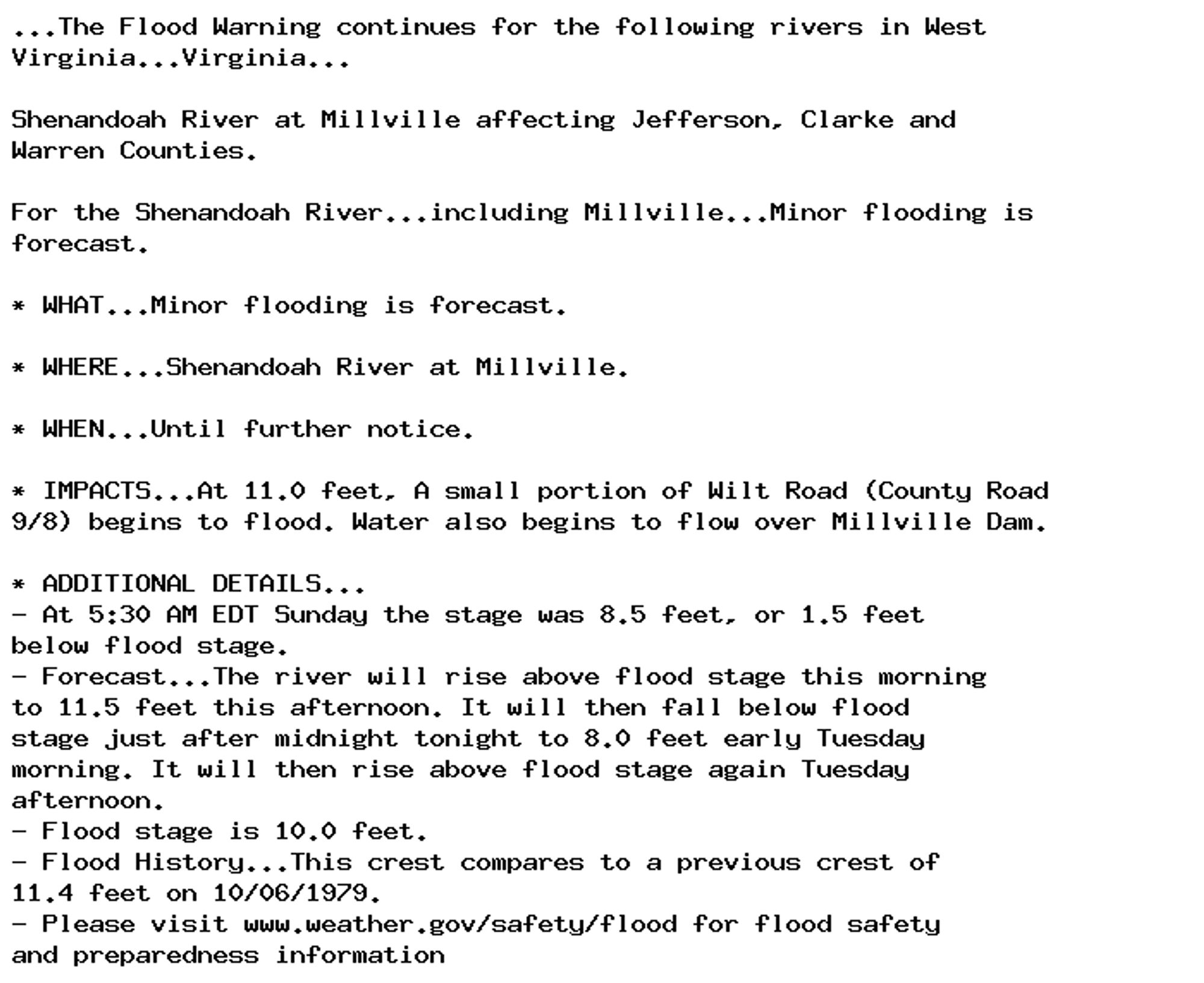
Flood Warning issued September 29 at 9:49AM EDT until September 30 at 4:24AM EDT by NWS Baltimore MD/Washington DC Additional Details Here.

...The Flood Warning is extended for the following rivers in
Virginia...

South Fork Shenandoah River at Front Royal affecting Warren
County.

...The Flood Warning continues for the following rivers in
Virginia...West Virginia...

Shenandoah River at Millville affecting Clarke, Jefferson and
Warren Counties.

For the Shenandoah River...including Millville...Minor flooding is
forecast.

* WHAT...Minor flooding is forecast.

* WHERE...Shenandoah River at Millville.

* WHEN...Until late tonight.

* IMPACTS...At 10.0 feet, Parts of Bloomery Road and John Rissler
Road are flooded near Bloomery, West Virginia. Once these roads
flood, access to homes is impaired but the homes themselves are
not in any danger of flooding. Moulton Park and the Millville boat
launch are also flooded.

* ADDITIONAL DETAILS...
- At 9:30 AM EDT Sunday the stage was 9.4 feet, or 0.6 feet
below flood stage.
- Forecast...The river is expected to rise above flood stage
this afternoon to a crest of 10.4 feet this afternoon. It
will then fall below flood stage late this evening.
- Flood stage is 10.0 feet.
- Flood History...This crest compares to a previous crest of
10.4 feet on 05/07/1988.
- Please visit www.weather.gov/safety/flood for flood safety
and preparedness information
0
AFwas.nws-bot.us

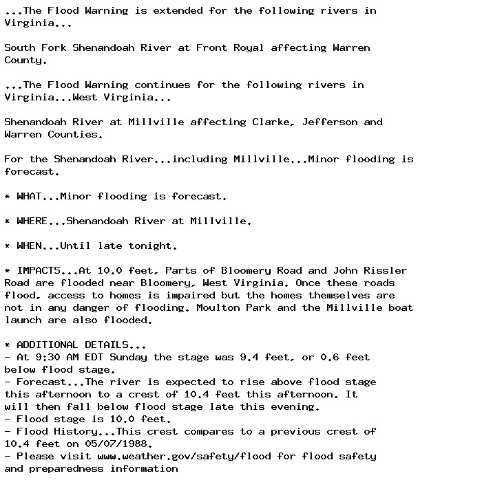
Flood Warning issued September 29 at 9:49AM EDT until September 29 at 5:37PM EDT by NWS Baltimore MD/Washington DC Additional Details Here.

...The Flood Warning is extended for the following rivers in
Virginia...

South Fork Shenandoah River at Front Royal affecting Warren
County.

...The Flood Warning continues for the following rivers in
Virginia...West Virginia...

Shenandoah River at Millville affecting Clarke, Jefferson and
Warren Counties.

For the Shenandoah River...including Millville...Minor flooding is
forecast.

* WHAT...Minor flooding is occurring.

* WHERE...South Fork Shenandoah River at Front Royal.

* WHEN...Until late this afternoon.

* IMPACTS...At 12.0 feet, Backwater begins to creep up Luray Avenue
toward the railroad trestle. A riverside parking area at the end
of Luray Avenue is flooded.

* ADDITIONAL DETAILS...
- At 9:32 AM EDT Sunday the stage was 12.4 feet, or 0.3 feet
above flood stage.
- Recent Activity...The maximum river stage in the 24 hours
ending at 9:32 AM EDT Sunday was 12.4 feet.
- Forecast...The river is expected to fall below flood stage
late this morning and continue falling to 8.9 feet Wednesday
morning.
- Flood stage is 12.0 feet.
- Flood History...This crest compares to a previous crest of
12.3 feet on 03/15/1978.
- Please visit www.weather.gov/safety/flood for flood safety
and preparedness information
0
AFwas.nws-bot.us

Flood Warning issued September 29 at 6:01AM EDT until September 29 at 11:24AM EDT by NWS Baltimore MD/Washington DC Additional Details Here.

...The Flood Warning continues for the following rivers in
Virginia...

South Fork Shenandoah River at Front Royal affecting Warren
County.

For the South Fork Shenandoah River...including Lynnwood, Luray,
Front Royal...Minor flooding is forecast.

* WHAT...Minor flooding is occurring and minor flooding is forecast.

* WHERE...South Fork Shenandoah River at Front Royal.

* WHEN...Until late this morning.

* IMPACTS...At 12.0 feet, Backwater begins to creep up Luray Avenue
toward the railroad trestle. A riverside parking area at the end
of Luray Avenue is flooded.

* ADDITIONAL DETAILS...
- At 5:17 AM EDT Sunday the stage was 12.0 feet, or 0.0 feet
above flood stage.
- Recent Activity...The maximum river stage in the 24 hours
ending at 5:17 AM EDT Sunday was 12.0 feet.
- Forecast...The river is expected to rise to a crest of 12.6
feet this morning. It will then fall below flood stage late
this morning.
- Flood stage is 12.0 feet.
- Flood History...This crest compares to a previous crest of
12.6 feet on 03/20/1983.
- Please visit www.weather.gov/safety/flood for flood safety
and preparedness information
0
AFwas.nws-bot.us

Flood Warning issued September 29 at 6:03AM EDT by NWS Baltimore MD/Washington DC Additional Details Here.

...The Flood Warning continues for the following rivers in West
Virginia...Virginia...

Shenandoah River at Millville affecting Jefferson, Clarke and
Warren Counties.

For the Shenandoah River...including Millville...Minor flooding is
forecast.

* WHAT...Minor flooding is forecast.

* WHERE...Shenandoah River at Millville.

* WHEN...Until further notice.

* IMPACTS...At 11.0 feet, A small portion of Wilt Road (County Road
9/8) begins to flood. Water also begins to flow over Millville Dam.

* ADDITIONAL DETAILS...
- At 5:30 AM EDT Sunday the stage was 8.5 feet, or 1.5 feet
below flood stage.
- Forecast...The river will rise above flood stage this morning
to 11.5 feet this afternoon. It will then fall below flood
stage just after midnight tonight to 8.0 feet early Tuesday
morning. It will then rise above flood stage again Tuesday
afternoon.
- Flood stage is 10.0 feet.
- Flood History...This crest compares to a previous crest of
11.4 feet on 10/06/1979.
- Please visit www.weather.gov/safety/flood for flood safety
and preparedness information
0
AFwas.nws-bot.us

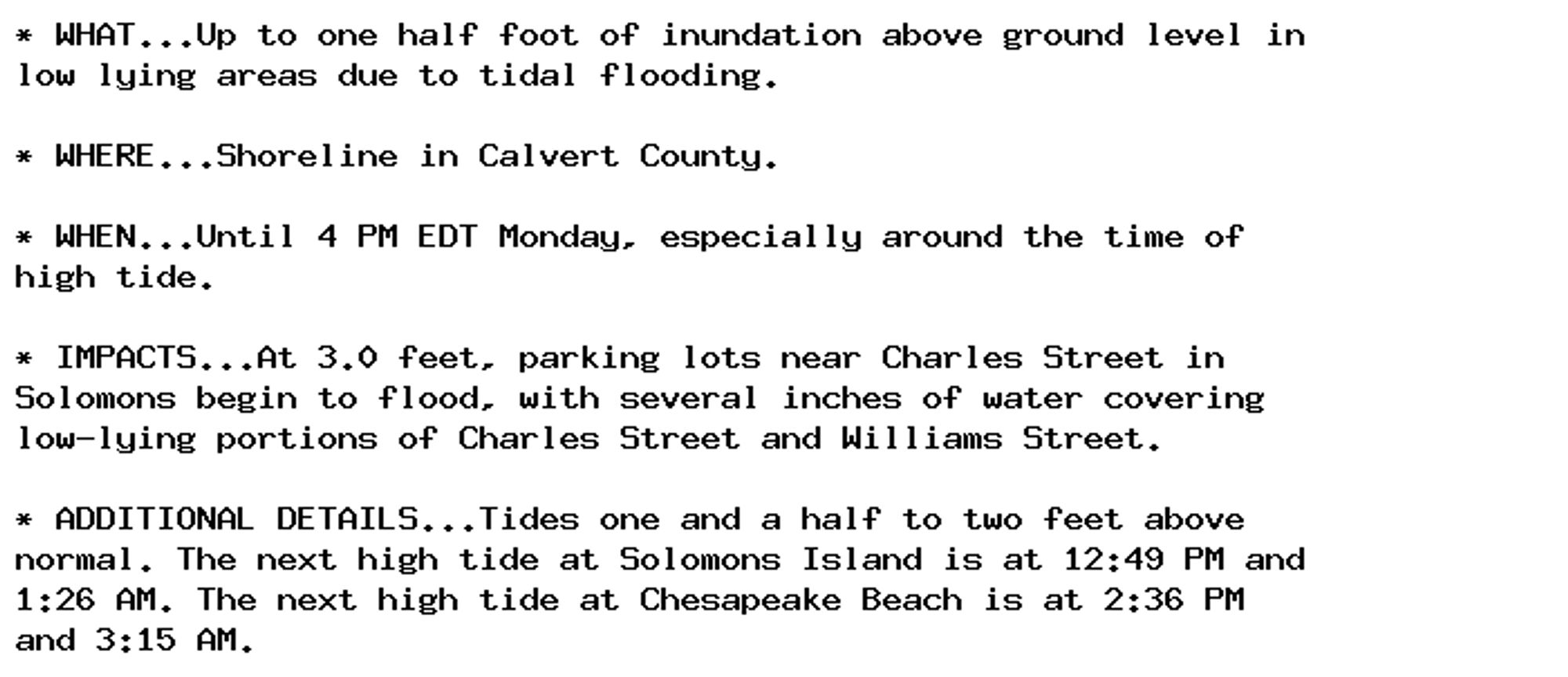
Coastal Flood Advisory issued September 29 at 3:35AM EDT until September 30 at 4:00PM EDT by NWS Baltimore MD/Washington DC Additional Details Here.

* WHAT...Up to one half foot of inundation above ground level in
low lying areas due to tidal flooding.

* WHERE...Shoreline in Calvert County.

* WHEN...Until 4 PM EDT Monday, especially around the time of
high tide.

* IMPACTS...At 3.0 feet, parking lots near Charles Street in
Solomons begin to flood, with several inches of water covering
low-lying portions of Charles Street and Williams Street.

* ADDITIONAL DETAILS...Tides one and a half to two feet above
normal. The next high tide at Solomons Island is at 12:49 PM and
1:26 AM. The next high tide at Chesapeake Beach is at 2:36 PM
and 3:15 AM.
0
AFwas.nws-bot.us

Coastal Flood Advisory issued September 29 at 3:35AM EDT until September 30 at 9:00PM EDT by NWS Baltimore MD/Washington DC Additional Details Here.

* WHAT...Up to one half foot of inundation above ground level in
low lying areas due to tidal flooding.

* WHERE...Shoreline in Anne Arundel County.

* WHEN...Until 9 PM EDT Monday, especially around the time of
high tide.

* IMPACTS...At 3.0 feet, Compromise Street begins to flood in
Annapolis. Flooding of much of the City Dock parking lot is
occurring.

* ADDITIONAL DETAILS...Tides one to one and a half feet above
normal. The next high tide at Annapolis U.S. Naval Academy is at
3:56 AM and 3:57 PM.
0
AFwas.nws-bot.us

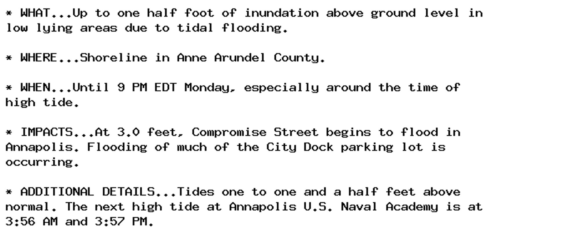
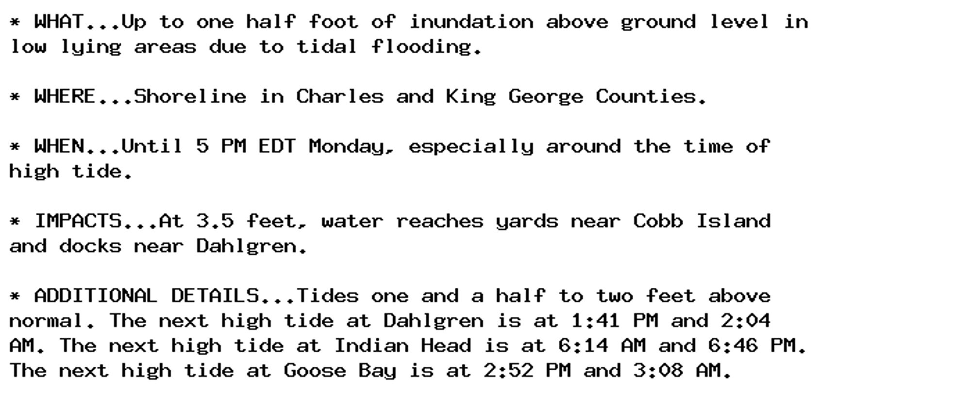
Coastal Flood Advisory issued September 29 at 3:35AM EDT until September 30 at 5:00PM EDT by NWS Baltimore MD/Washington DC Additional Details Here.

* WHAT...Up to one half foot of inundation above ground level in
low lying areas due to tidal flooding.

* WHERE...Shoreline in Charles and King George Counties.

* WHEN...Until 5 PM EDT Monday, especially around the time of
high tide.

* IMPACTS...At 3.5 feet, water reaches yards near Cobb Island
and docks near Dahlgren.

* ADDITIONAL DETAILS...Tides one and a half to two feet above
normal. The next high tide at Dahlgren is at 1:41 PM and 2:04
AM. The next high tide at Indian Head is at 6:14 AM and 6:46 PM.
The next high tide at Goose Bay is at 2:52 PM and 3:08 AM.
0
AF
Alerts from NWS Baltimore MD/Washington DC (UNOFFICIAL)
@was.nws-bot.us
Unofficial bot sharing NWS alerts for the Baltimore MD/Washington DC area. This account is not monitored. Contact @wandrme.paxex.aero if needed.
950 followers1 following92 posts