BLUE
Lpedrohlfg.bsky.social

Pegando o 313 p ir pro cpa mas nem lembro se ele me deixa no terminal do cpa 2 mesmo kkkkkk

0
Mmetropoles.com

🤑 Mega-Sena: aposta do DF acerta cinco números e leva R$ 55 mil na quina A aposta, simples, foi feita na Loteria Superchance, na 313 Norte Leia: curt.link/SYdim

1
cory-langley.bsky.social

Staying home 313 days a year due to no public transit options is not something I would wish on someone.

0
NHnhc-atlc.nws-bot.us

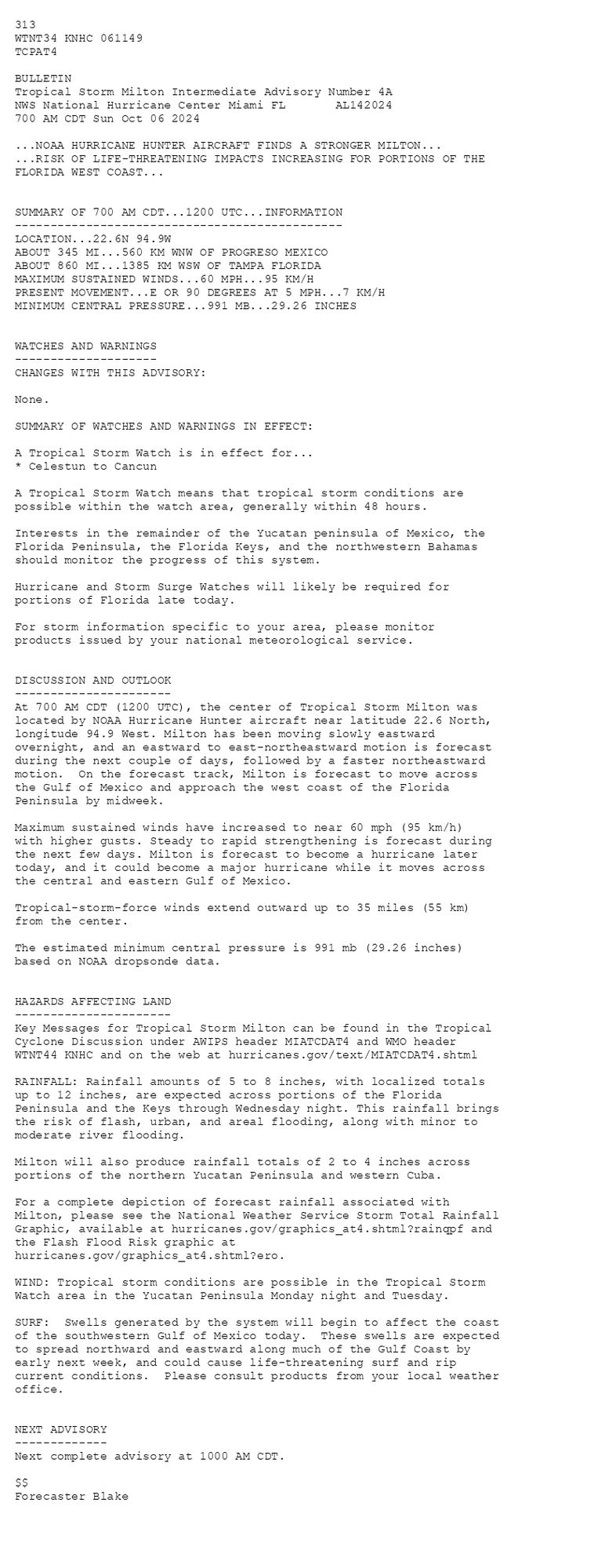
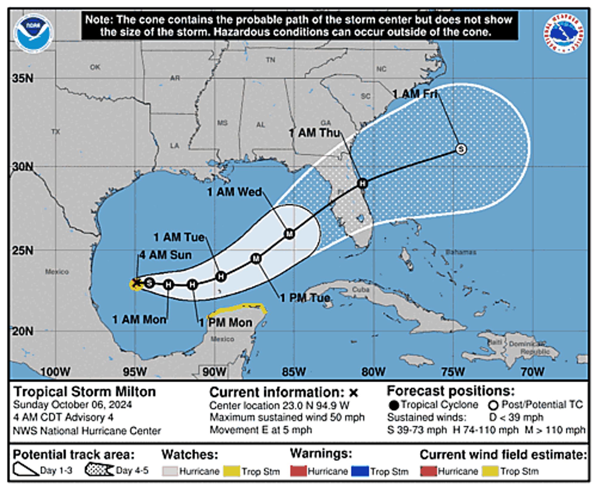
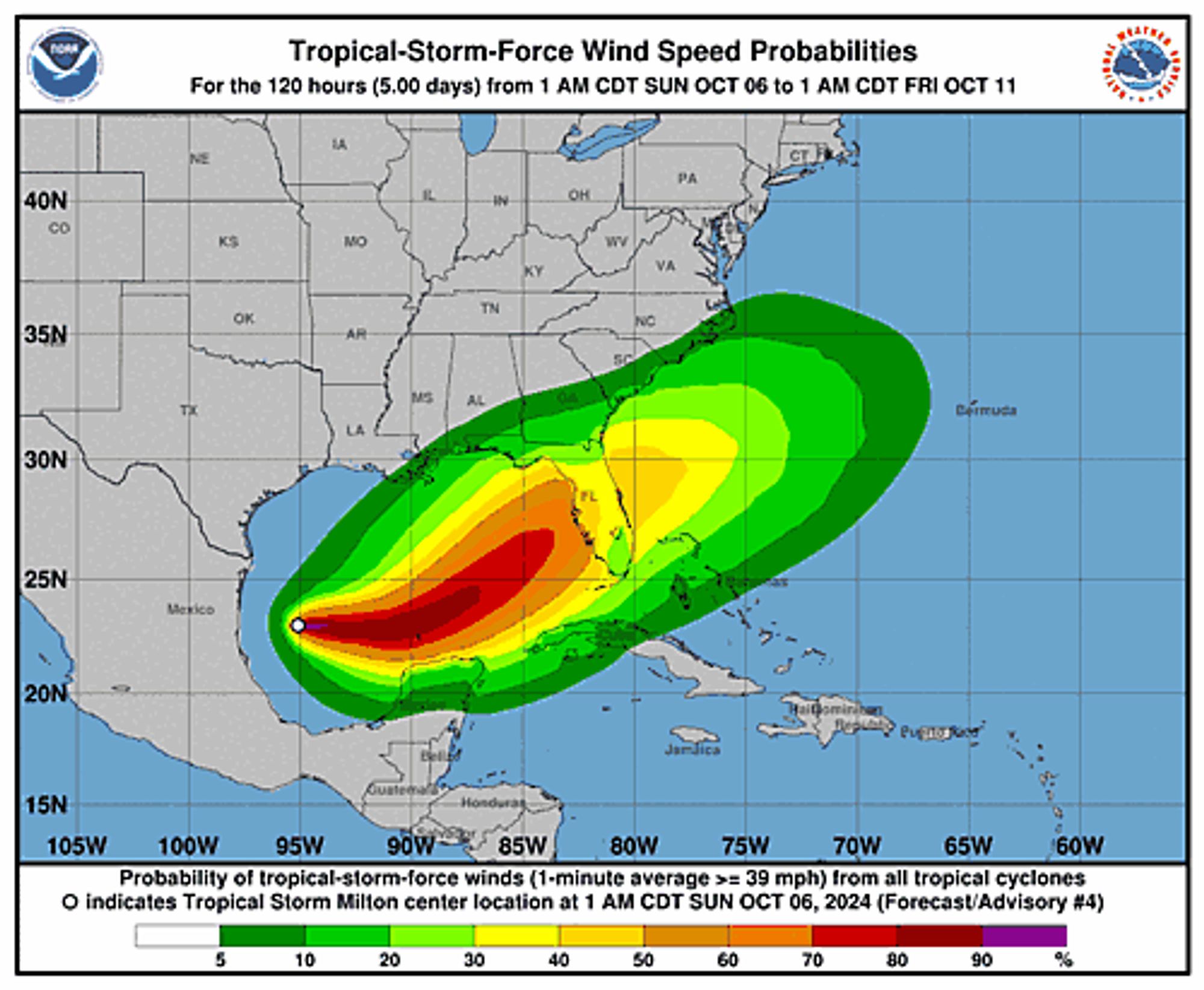
Atlantic Tropical Storm Milton Intermediate Advisory Number 4A issued at Sun, 06 Oct 2024 11:49:51 +0000 ...NOAA HURRICANE HUNTER AIRCRAFT FINDS A STRONGER MILTON... ...RISK OF LIFE-THREATENING IMPACTS INCREASING FOR PORTIONS OF THE FLORIDA WEST COAST... Additional Details Here.


 <br />
 313 <br />
 WTNT34 KNHC 061149<br />
 TCPAT4<br />
  <br />
 BULLETIN<br />
 Tropical Storm Milton Intermediate Advisory Number 4A<br />
 NWS National Hurricane Center Miami FL       AL142024<br />
 700 AM CDT Sun Oct 06 2024<br />
  <br />
 ...NOAA HURRICANE HUNTER AIRCRAFT FINDS A STRONGER MILTON...<br />
 ...RISK OF LIFE-THREATENING IMPACTS INCREASING FOR PORTIONS OF THE<br />
 FLORIDA WEST COAST...<br />
  <br />
  <br />
 SUMMARY OF 700 AM CDT...1200 UTC...INFORMATION<br />
 ----------------------------------------------<br />
 LOCATION...22.6N 94.9W<br />
 ABOUT 345 MI...560 KM WNW OF PROGRESO MEXICO<br />
 ABOUT 860 MI...1385 KM WSW OF TAMPA FLORIDA<br />
 MAXIMUM SUSTAINED WINDS...60 MPH...95 KM/H<br />
 PRESENT MOVEMENT...E OR 90 DEGREES AT 5 MPH...7 KM/H<br />
 MINIMUM CENTRAL PRESSURE...991 MB...29.26 INCHES<br />
  <br />
  <br />
 WATCHES AND WARNINGS<br />
 --------------------<br />
 CHANGES WITH THIS ADVISORY:<br />
  <br />
 None.<br />
  <br />
 SUMMARY OF WATCHES AND WARNINGS IN EFFECT:<br />
  <br />
 A Tropical Storm Watch is in effect for...<br />
 * Celestun to Cancun<br />
  <br />
 A Tropical Storm Watch means that tropical storm conditions are<br />
 possible within the watch area, generally within 48 hours.<br />
  <br />
 Interests in the remainder of the Yucatan peninsula of Mexico, the<br />
 Florida Peninsula, the Florida Keys, and the northwestern Bahamas<br />
 should monitor the progress of this system.<br />
  <br />
 Hurricane and Storm Surge Watches will likely be required for<br />
 portions of Florida late today.<br />
  <br />
 For storm information specific to your area, please monitor<br />
 products issued by your national meteorological service.<br />
  <br />
  <br />
 DISCUSSION AND OUTLOOK<br />
 ----------------------<br />
 At 700 AM CDT (1200 UTC), the center of Tropical Storm Milton was <br />
 located by NOAA Hurricane Hunter aircraft near latitude 22.6 North, <br />
 longitude 94.9 West. Milton has been moving slowly eastward <br />
 overnight, and an eastward to east-northeastward motion is forecast <br />
 during the next couple of days, followed by a faster northeastward <br />
 motion.  On the forecast track, Milton is forecast to move across <br />
 the Gulf of Mexico and approach the west coast of the Florida <br />
 Peninsula by midweek.<br />
  <br />
 Maximum sustained winds have increased to near 60 mph (95 km/h)<br />
 with higher gusts. Steady to rapid strengthening is forecast during<br />
 the next few days. Milton is forecast to become a hurricane later <br />
 today, and it could become a major hurricane while it moves across <br />
 the central and eastern Gulf of Mexico.<br />
  <br />
 Tropical-storm-force winds extend outward up to 35 miles (55 km)<br />
 from the center.<br />
  <br />
 The estimated minimum central pressure is 991 mb (29.26 inches) <br />
 based on NOAA dropsonde data.<br />
  <br />
  <br />
 HAZARDS AFFECTING LAND<br />
 ----------------------<br />
 Key Messages for Tropical Storm Milton can be found in the Tropical<br />
 Cyclone Discussion under AWIPS header MIATCDAT4 and WMO header<br />
 WTNT44 KNHC and on the web at hurricanes.gov/text/MIATCDAT4.shtml<br />
  <br />
 RAINFALL: Rainfall amounts of 5 to 8 inches, with localized totals<br />
 up to 12 inches, are expected across portions of the Florida<br />
 Peninsula and the Keys through Wednesday night. This rainfall brings<br />
 the risk of flash, urban, and areal flooding, along with minor to<br />
 moderate river flooding.<br />
  <br />
 Milton will also produce rainfall totals of 2 to 4 inches across<br />
 portions of the northern Yucatan Peninsula and western Cuba.<br />
  <br />
 For a complete depiction of forecast rainfall associated with<br />
 Milton, please see the National Weather Service Storm Total Rainfall<br />
 Graphic, available at hurricanes.gov/graphics_at4.shtml?rainqpf and<br />
 the Flash Flood Risk graphic at<br />
 hurricanes.gov/graphics_at4.shtml?ero.<br />
  <br />
 WIND: Tropical storm conditions are possible in the Tropical Storm<br />
 Watch area in the Yucatan Peninsula Monday night and Tuesday.<br />
  <br />
 SURF:  Swells generated by the system will begin to affect the coast<br />
 of the southwestern Gulf of Mexico today.  These swells are expected<br />
 to spread northward and eastward along much of the Gulf Coast by<br />
 early next week, and could cause life-threatening surf and rip<br />
 current conditions.  Please consult products from your local weather<br />
 office.<br />
  <br />
  <br />
 NEXT ADVISORY<br />
 -------------<br />
 Next complete advisory at 1000 AM CDT.<br />
  <br />
 $$<br />
 Forecaster Blake<br />
  <br />
 <br />
Tropical Storm Milton 5-Day Uncertainty Track Image
Tropical Storm Milton 34-Knot Wind Speed Probabilities
0
Pbeepeepum.bsky.social

313

0