BLUE
aaronwalsman.bsky.social

At ECCV 2024, ping if you want to discuss embodied and multi-agent learning, or swing by poster 89 on Thursday afternoon to check out our latest work on LEGO AI!

0

Thank you, I think I may be a bit better, but there's a long way to go. I don't see myself as brave, I must admit. I'm just determined. 🤣 First lesson went well; we'll see what this afternoon brings. Maybe 2 no-shows? I'm paranoid about Marmite leaving now. The window is shut except when I'm smokingThank you, I think I may be a bit better, but there's a long way to go. I don't see myself as brave, I must admit. I'm just determined. 🤣 First lesson went well; we'll see what this afternoon brings. Maybe 2 no-shows? I'm paranoid about Marmite leaving now. The window is shut except when I'm smoking

0
RPrackletang.bsky.social

Also I fell asleep this afternoon watching an aviation video and had a sexy dream about the host/narrator. I'm not even attracted to him, I don't think, and anyway it was more of a dating dream? Also a slumlord/ broken plumbing dream. And a big concert. I contain multitudes. Real weird multitudes.

0
Jjoyilta.bsky.social

Good afternoon, fella. For a while I stared into a world map searching for peaceful places, but truth is there is disturbance almost everywhere, in different degrees of intensity and scale 😵‍💫 one more reason to fight the good fight #MUGA

0

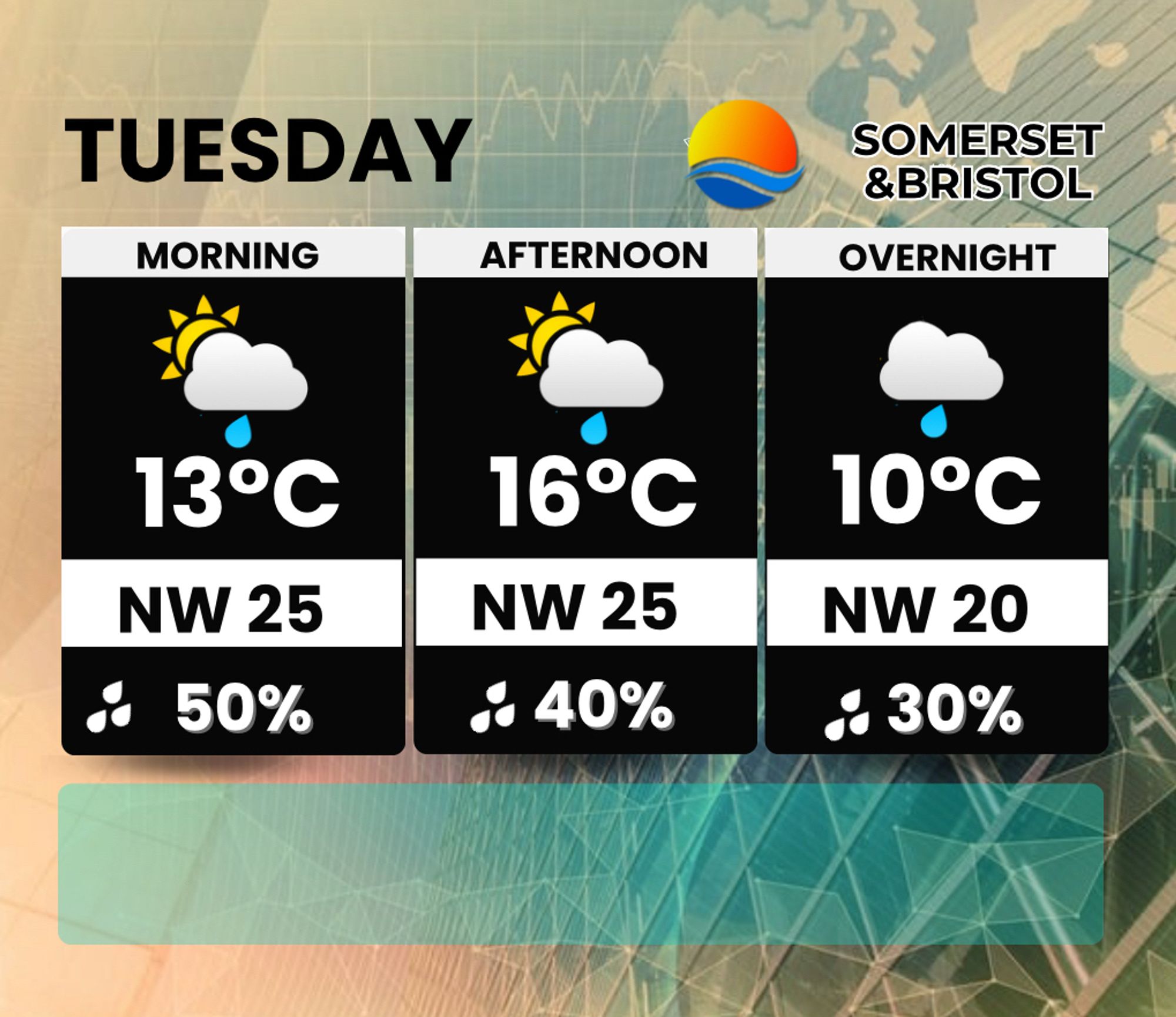
Tuesday The morning will have a mix of sunny spells and the risk of some showers. The afternoon Increasing cloud still with the risk of a shower in places max 15° or 16° windy. Overnight Cloudy with some light rain in places lows 10°

0
AFlax.nws-bot.us

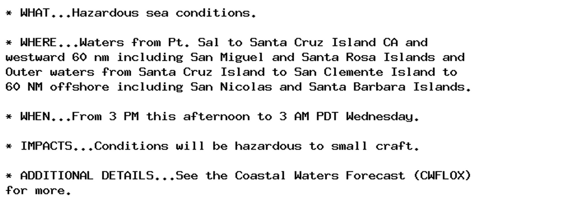
Small Craft Advisory issued October 1 at 2:29AM PDT until October 2 at 3:00AM PDT by NWS Los Angeles/Oxnard CA Additional Details Here.

* WHAT...Hazardous sea conditions.

* WHERE...Waters from Pt. Sal to Santa Cruz Island CA and
westward 60 nm including San Miguel and Santa Rosa Islands and
Outer waters from Santa Cruz Island to San Clemente Island to
60 NM offshore including San Nicolas and Santa Barbara Islands.

* WHEN...From 3 PM this afternoon to 3 AM PDT Wednesday.

* IMPACTS...Conditions will be hazardous to small craft.

* ADDITIONAL DETAILS...See the Coastal Waters Forecast (CWFLOX)
for more.
0
AFlax.nws-bot.us

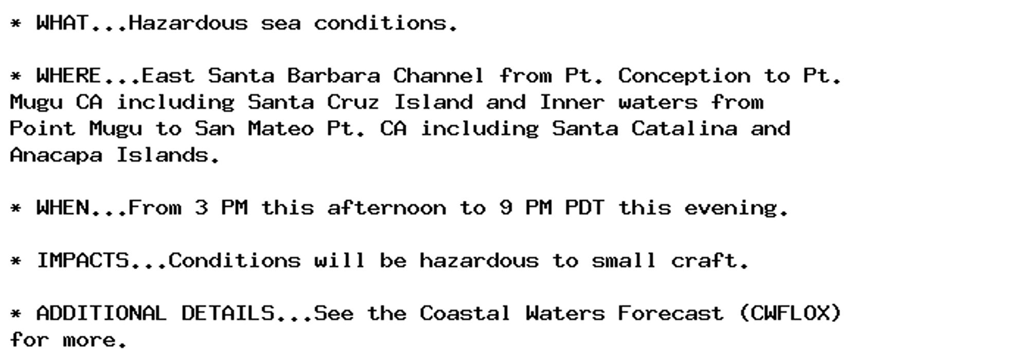
Small Craft Advisory issued October 1 at 2:29AM PDT until October 1 at 9:00PM PDT by NWS Los Angeles/Oxnard CA Additional Details Here.

* WHAT...Hazardous sea conditions.

* WHERE...East Santa Barbara Channel from Pt. Conception to Pt.
Mugu CA including Santa Cruz Island and Inner waters from
Point Mugu to San Mateo Pt. CA including Santa Catalina and
Anacapa Islands.

* WHEN...From 3 PM this afternoon to 9 PM PDT this evening.

* IMPACTS...Conditions will be hazardous to small craft.

* ADDITIONAL DETAILS...See the Coastal Waters Forecast (CWFLOX)
for more.
0
Gdrewdew.bsky.social

Late afternoon chilling.

0
AFrdu.nws-bot.us

🚨 Flood Warning issued October 1 at 5:04AM EDT by NWS Raleigh NC 🚨 Additional Details Here.

...The Flood Warning is extended for the following rivers in North
Carolina...

Neuse River Near Goldsboro affecting Wayne County.

...The Flood Warning continues for the following rivers in North
Carolina...

Neuse River At Smithfield affecting Johnston County.

* WHAT...Minor flooding is occurring and minor flooding is forecast.

* WHERE...Neuse River at Smithfield.

* WHEN...Until further notice.

* IMPACTS...At 15.0 feet, Minor flooding begins. Flooding begins
along the Neuse Riverwalk. Water nears the base of the holding
tank at the water treatment plant.
At 18.0 feet, Moderate flooding begins. The Smithfield town park
and the Neuse Riverwalk at the US70 bridge are flooded.

* ADDITIONAL DETAILS...
- At 4:15 AM EDT Tuesday the stage was 15.2 feet.
- Recent Activity...The maximum river stage in the 24 hours
ending at 4:15 AM EDT Tuesday was 15.2 feet.
- Forecast...The river is expected to rise to 16.0 feet early
Friday afternoon. Additional rises are possible thereafter.
- Flood stage is 15.0 feet.
- Flood History...This crest compares to a previous crest of
15.0 feet on 10/13/2018.
- http://www.weather.gov/safety/flood
0
AFrdu.nws-bot.us

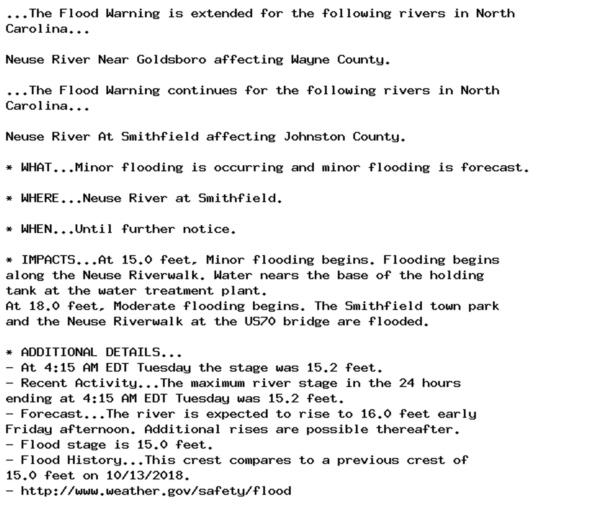
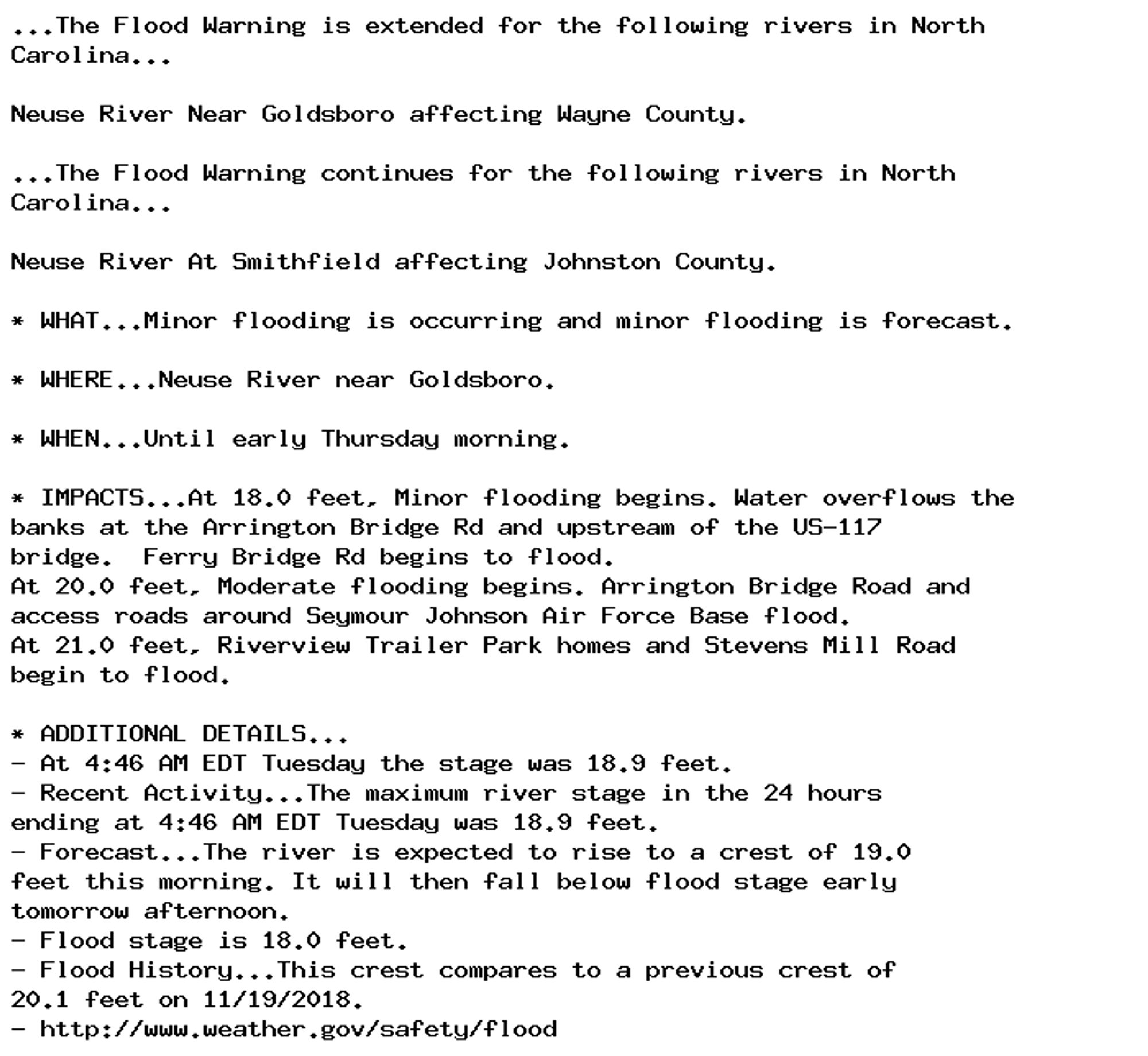
🚨 Flood Warning issued October 1 at 5:04AM EDT until October 3 at 2:00AM EDT by NWS Raleigh NC 🚨 Additional Details Here.

...The Flood Warning is extended for the following rivers in North
Carolina...

Neuse River Near Goldsboro affecting Wayne County.

...The Flood Warning continues for the following rivers in North
Carolina...

Neuse River At Smithfield affecting Johnston County.

* WHAT...Minor flooding is occurring and minor flooding is forecast.

* WHERE...Neuse River near Goldsboro.

* WHEN...Until early Thursday morning.

* IMPACTS...At 18.0 feet, Minor flooding begins. Water overflows the
banks at the Arrington Bridge Rd and upstream of the US-117
bridge.  Ferry Bridge Rd begins to flood.
At 20.0 feet, Moderate flooding begins. Arrington Bridge Road and
access roads around Seymour Johnson Air Force Base flood.
At 21.0 feet, Riverview Trailer Park homes and Stevens Mill Road
begin to flood.

* ADDITIONAL DETAILS...
- At 4:46 AM EDT Tuesday the stage was 18.9 feet.
- Recent Activity...The maximum river stage in the 24 hours
ending at 4:46 AM EDT Tuesday was 18.9 feet.
- Forecast...The river is expected to rise to a crest of 19.0
feet this morning. It will then fall below flood stage early
tomorrow afternoon.
- Flood stage is 18.0 feet.
- Flood History...This crest compares to a previous crest of
20.1 feet on 11/19/2018.
- http://www.weather.gov/safety/flood
0