BLUE

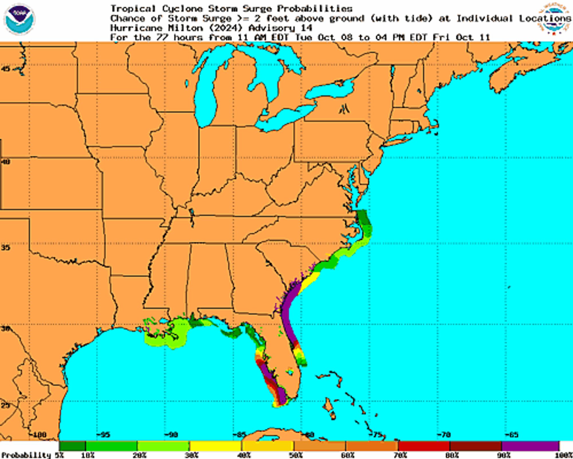
NEW WEATHER ADVISORY: Tropical Cyclone Statement HLSMFL This product covers South Florida **Major Hurricane Milton Continues to move through the Southern Gulf of Mexico** NEW INFORMATION --------------- * CHANGES TO WATCHES AND WARNINGS: - None *... See more: watchedsky.social/app/alerts/...

0

NEW WEATHER ADVISORY: Tropical Cyclone Statement HLSJAX This product covers Northeast Florida and Southeast Georgia **MILTON FORECAST TO RETAIN MAJOR HURRICANE STATUS AND EXPAND IN SIZE WHILE IT APPROACHES THE WEST COAST OF FLORIDA ON WEDNESDAY** NEW... See more: watchedsky.social/app/alerts/...

0

NEW WEATHER ADVISORY: Tropical Cyclone Statement HLSTAE This product covers eastern Florida panhandle, Florida Big Bend, southeastern Alabama and southwestern Georgia **PERIPHERAL RAIN AND WIND IMPACTS ACROSS THE EASTERN FLORIDA BIG BEND FROM MAJOR... See more: watchedsky.social/app/alerts/...

0

it took some time but something clicked with me and i really love getting to draw isometric rooms, i really jumped in at the deepend with doing the pizza place but i it was really fun

an isometric pixel art rendition of the freddy fazbears pizza place arcade, from middle to right there are stairs leading down into the arcade from the main diner, two upright arcade machines, midnight motorist and asteriods, two cyclone machines, three basketball shooting games and four pinball games, there is a door leading out indented into the wall and a claw machine, on the middle to the right there is a small merry go round with bear, chicken and rabbit rides, a chance machine and a DDR machine, three arcade cabnets, princess quest, "puck" man and polybius, there is another door and two more arcade cabnets, in the bottom left of center of the image is the ballpit that is indented down and has a yellow rabbit animatronic peeking out of it, the balls of the ballpit are spread out below the main space of the image and scatter as they get further down, the space is littered with cups, party hats, snacks, and plushies
isometric pixel art image of backstage at freddy fazbears pizza place, there is a workbench with party hats and foxys head ontop of it, a paper garland cut to resemble people that is bloodstained, a mountain of presents, there is a pizza with plates, a cake under a small lightbulb spotlight, chica the chicken and bonnie the bunny are facing away from the camera they are in a broken down state, chica is missing atleast one of her arms and bonnie does not have the front of his face, he is holding his guitar, from behind a purple starry curtain glitchtrap is peaking out
isometric pixel art of the main diner of freddy fazbears pizza place, from left to right there is the main enterance, a ticket counter, a gumball and a gashapon machine, four boothe style seating spaces with character art of bonnie, chica, foxy and freddy decorating the partition walls with glass, a service counter and resturant menu, a jukebox, six party tables in various states of use, a side stage for foxy, a main stage for bonnie freddy and chica and three pinball machines, there are some stairs and a neon sign pointing to the arcade
0
NHnhc-atlc.nws-bot.us

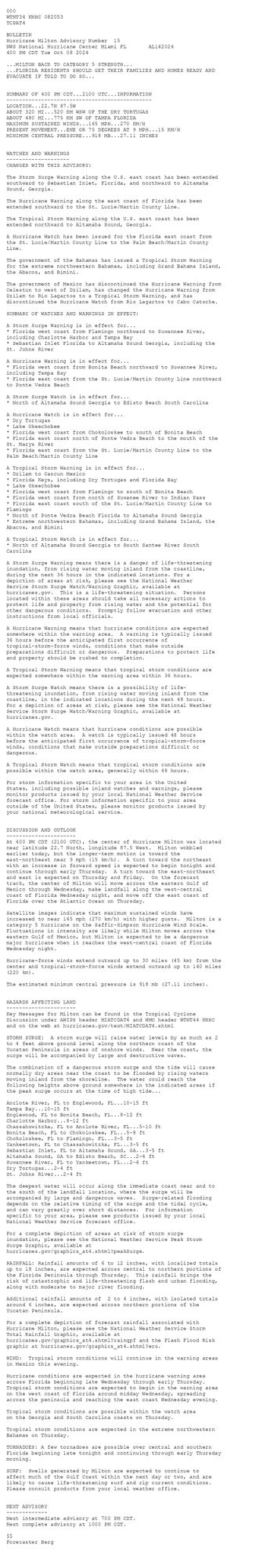
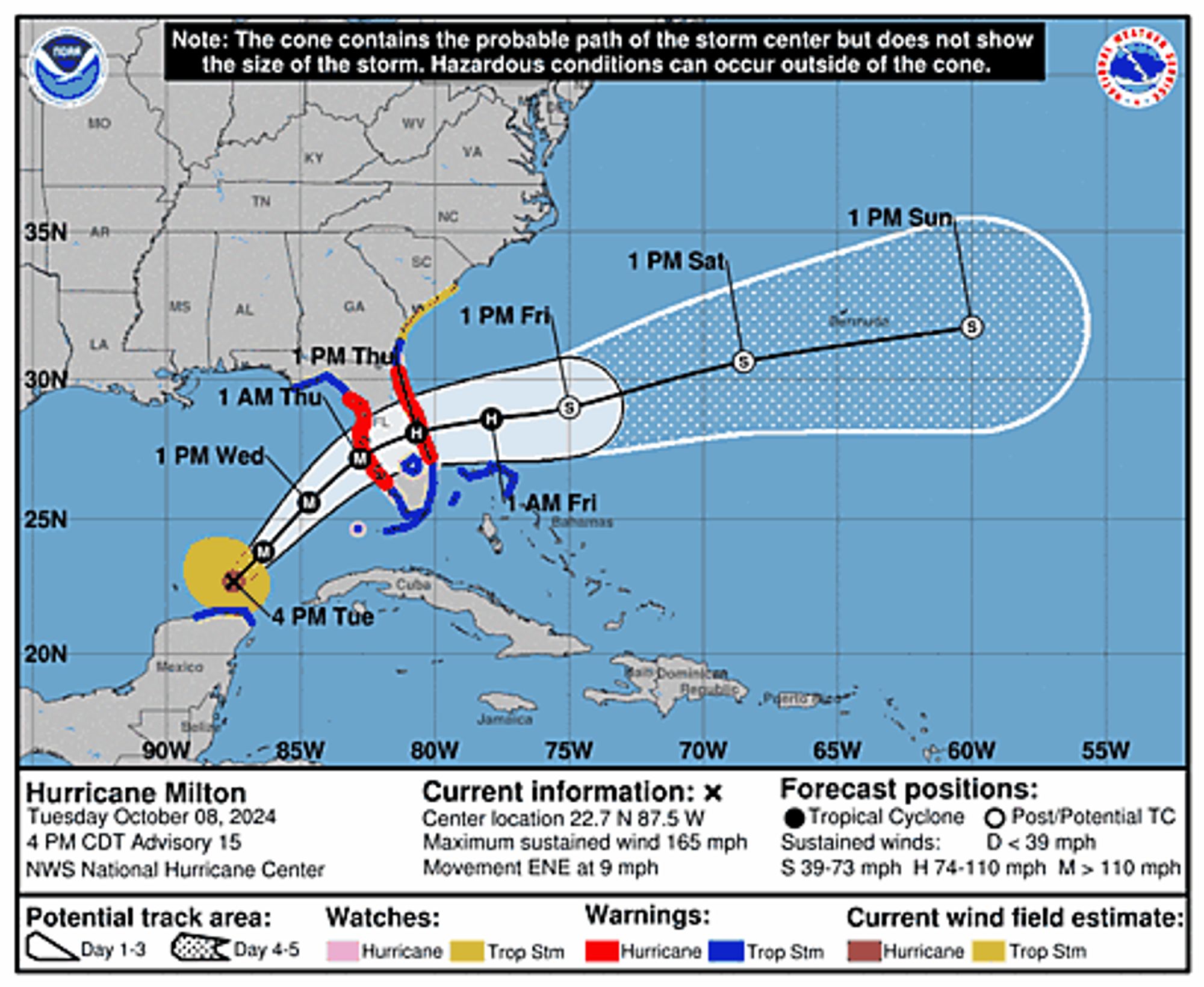
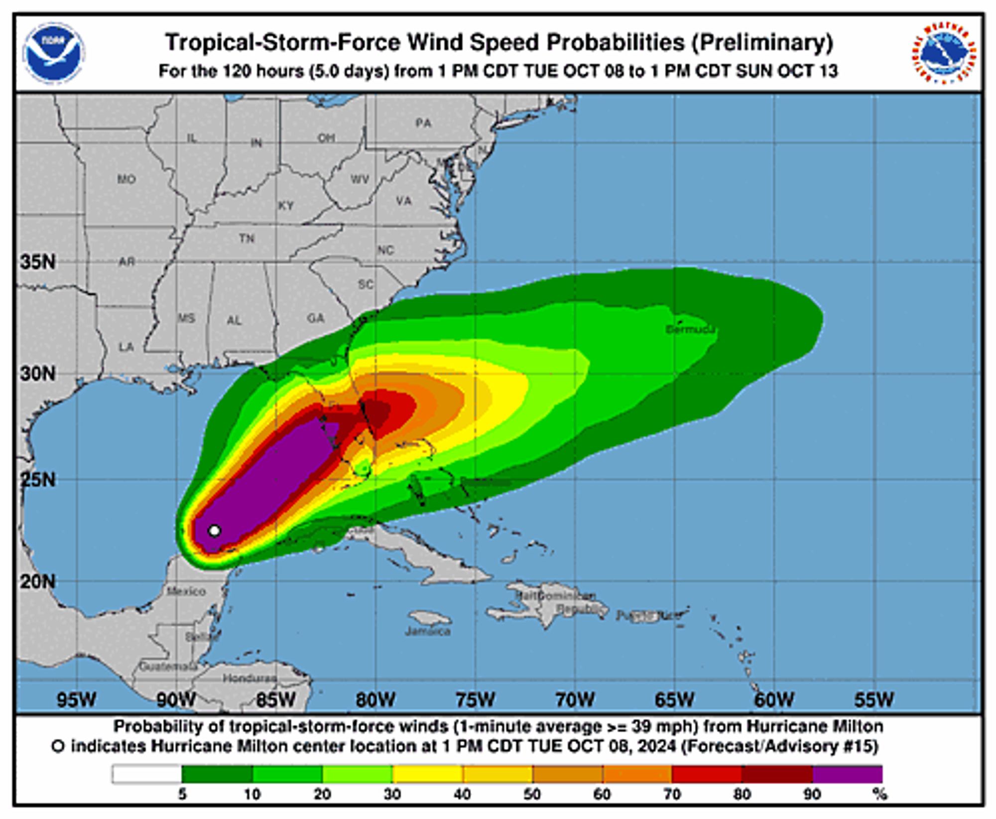
Atlantic Hurricane Milton Advisory Number 15 issued at Tue, 08 Oct 2024 20:53:48 +0000 ...MILTON BACK TO CATEGORY 5 STRENGTH... ...FLORIDA RESIDENTS SHOULD GET THEIR FAMILIES AND HOMES READY AND EVACUATE IF TOLD TO DO SO... Additional Details Here.


 <br />
 000<br />
 WTNT34 KNHC 082053<br />
 TCPAT4<br />
  <br />
 BULLETIN<br />
 Hurricane Milton Advisory Number  15<br />
 NWS National Hurricane Center Miami FL       AL142024<br />
 400 PM CDT Tue Oct 08 2024<br />
  <br />
 ...MILTON BACK TO CATEGORY 5 STRENGTH...<br />
 ...FLORIDA RESIDENTS SHOULD GET THEIR FAMILIES AND HOMES READY AND<br />
 EVACUATE IF TOLD TO DO SO...<br />
  <br />
  <br />
 SUMMARY OF 400 PM CDT...2100 UTC...INFORMATION<br />
 ----------------------------------------------<br />
 LOCATION...22.7N 87.5W<br />
 ABOUT 320 MI...520 KM WSW OF THE DRY TORTUGAS<br />
 ABOUT 480 MI...775 KM SW OF TAMPA FLORIDA<br />
 MAXIMUM SUSTAINED WINDS...165 MPH...270 KM/H<br />
 PRESENT MOVEMENT...ENE OR 75 DEGREES AT 9 MPH...15 KM/H<br />
 MINIMUM CENTRAL PRESSURE...918 MB...27.11 INCHES<br />
  <br />
  <br />
 WATCHES AND WARNINGS<br />
 --------------------<br />
 CHANGES WITH THIS ADVISORY:<br />
  <br />
 The Storm Surge Warning along the U.S. east coast has been extended<br />
 southward to Sebastian Inlet, Florida, and northward to Altamaha<br />
 Sound, Georgia.<br />
  <br />
 The Hurricane Warning along the east coast of Florida has been<br />
 extended southward to the St. Lucie/Martin County Line.<br />
  <br />
 The Tropical Storm Warning along the U.S. east coast has been<br />
 extended northward to Altamaha Sound, Georgia.<br />
  <br />
 A Hurricane Watch has been issued for the Florida east coast from<br />
 the St. Lucie/Martin County Line to the Palm Beach/Martin County<br />
 Line.<br />
  <br />
 The government of the Bahamas has issued a Tropical Storm Warning<br />
 for the extreme northwestern Bahamas, including Grand Bahama Island,<br />
 the Abacos, and Bimini.<br />
  <br />
 The government of Mexico has discontinued the Hurricane Warning from<br />
 Celestun to west of Dzilam, has changed the Hurricane Warning from<br />
 Dzilam to Rio Lagartos to a Tropical Storm Warning, and has<br />
 discontinued the Hurricane Watch from Rio Lagartos to Cabo Catoche.<br />
  <br />
 SUMMARY OF WATCHES AND WARNINGS IN EFFECT:<br />
  <br />
 A Storm Surge Warning is in effect for...<br />
 * Florida west coast from Flamingo northward to Suwannee River,<br />
 including Charlotte Harbor and Tampa Bay<br />
 * Sebastian Inlet Florida to Altamaha Sound Georgia, including the<br />
 St. Johns River<br />
  <br />
 A Hurricane Warning is in effect for...<br />
 * Florida west coast from Bonita Beach northward to Suwannee River,<br />
 including Tampa Bay<br />
 * Florida east coast from the St. Lucie/Martin County Line northward<br />
 to Ponte Vedra Beach<br />
  <br />
 A Storm Surge Watch is in effect for...<br />
 * North of Altamaha Sound Georgia to Edisto Beach South Carolina<br />
  <br />
 A Hurricane Watch is in effect for...<br />
 * Dry Tortugas<br />
 * Lake Okeechobee<br />
 * Florida west coast from Chokoloskee to south of Bonita Beach<br />
 * Florida east coast north of Ponte Vedra Beach to the mouth of the<br />
 St. Marys River<br />
 * Florida east coast from the St. Lucie/Martin County Line to the<br />
 Palm Beach/Martin County Line<br />
  <br />
 A Tropical Storm Warning is in effect for...<br />
 * Dzilam to Cancun Mexico<br />
 * Florida Keys, including Dry Tortugas and Florida Bay<br />
 * Lake Okeechobee<br />
 * Florida west coast from Flamingo to south of Bonita Beach<br />
 * Florida west coast from north of Suwanee River to Indian Pass<br />
 * Florida east coast south of the St. Lucie/Martin County Line to<br />
 Flamingo<br />
 * North of Ponte Vedra Beach Florida to Altamaha Sound Georgia<br />
 * Extreme northwestern Bahamas, including Grand Bahama Island, the<br />
 Abacos, and Bimini<br />
  <br />
 A Tropical Storm Watch is in effect for...<br />
 * North of Altamaha Sound Georgia to South Santee River South<br />
 Carolina<br />
  <br />
 A Storm Surge Warning means there is a danger of life-threatening<br />
 inundation, from rising water moving inland from the coastline,<br />
 during the next 36 hours in the indicated locations. For a<br />
 depiction of areas at risk, please see the National Weather<br />
 Service Storm Surge Watch/Warning Graphic, available at<br />
 hurricanes.gov.  This is a life-threatening situation.  Persons<br />
 located within these areas should take all necessary actions to<br />
 protect life and property from rising water and the potential for<br />
 other dangerous conditions.  Promptly follow evacuation and other<br />
 instructions from local officials.<br />
  <br />
 A Hurricane Warning means that hurricane conditions are expected<br />
 somewhere within the warning area.  A warning is typically issued<br />
 36 hours before the anticipated first occurrence of<br />
 tropical-storm-force winds, conditions that make outside<br />
 preparations difficult or dangerous.  Preparations to protect life<br />
 and property should be rushed to completion.<br />
  <br />
 A Tropical Storm Warning means that tropical storm conditions are<br />
 expected somewhere within the warning area within 36 hours.<br />
  <br />
 A Storm Surge Watch means there is a possibility of life-<br />
 threatening inundation, from rising water moving inland from the<br />
 coastline, in the indicated locations during the next 48 hours.<br />
 For a depiction of areas at risk, please see the National Weather<br />
 Service Storm Surge Watch/Warning Graphic, available at<br />
 hurricanes.gov.<br />
  <br />
 A Hurricane Watch means that hurricane conditions are possible<br />
 within the watch area.  A watch is typically issued 48 hours<br />
 before the anticipated first occurrence of tropical-storm-force<br />
 winds, conditions that make outside preparations difficult or<br />
 dangerous.<br />
  <br />
 A Tropical Storm Watch means that tropical storm conditions are<br />
 possible within the watch area, generally within 48 hours.<br />
  <br />
 For storm information specific to your area in the United<br />
 States, including possible inland watches and warnings, please<br />
 monitor products issued by your local National Weather Service<br />
 forecast office. For storm information specific to your area<br />
 outside of the United States, please monitor products issued by<br />
 your national meteorological service.<br />
  <br />
  <br />
 DISCUSSION AND OUTLOOK<br />
 ----------------------<br />
 At 400 PM CDT (2100 UTC), the center of Hurricane Milton was located<br />
 near latitude 22.7 North, longitude 87.5 West.  Milton wobbled<br />
 earlier today, but the longer-term motion is toward the<br />
 east-northeast near 9 mph (15 km/h).  A turn toward the northeast<br />
 with an increase in forward speed is expected to begin tonight and<br />
 continue through early Thursday.  A turn toward the east-northeast<br />
 and east is expected on Thursday and Friday.  On the forecast<br />
 track, the center of Milton will move across the eastern Gulf of<br />
 Mexico through Wednesday, make landfall along the west-central<br />
 coast of Florida Wednesday night, and move off the east coast of<br />
 Florida over the Atlantic Ocean on Thursday.<br />
  <br />
 Satellite images indicate that maximum sustained winds have<br />
 increased to near 165 mph (270 km/h) with higher gusts.  Milton is a<br />
 category 5 hurricane on the Saffir-Simpson Hurricane Wind Scale.<br />
 Fluctuations in intensity are likely while Milton moves across the<br />
 eastern Gulf of Mexico, but Milton is expected to be a dangerous<br />
 major hurricane when it reaches the west-central coast of Florida<br />
 Wednesday night.<br />
  <br />
 Hurricane-force winds extend outward up to 30 miles (45 km) from the<br />
 center and tropical-storm-force winds extend outward up to 140 miles<br />
 (220 km).<br />
  <br />
 The estimated minimum central pressure is 918 mb (27.11 inches).<br />
  <br />
  <br />
 HAZARDS AFFECTING LAND<br />
 ----------------------<br />
 Key Messages for Milton can be found in the Tropical Cyclone<br />
 Discussion under AWIPS header MIATCDAT4 and WMO header WTNT44 KNHC<br />
 and on the web at hurricanes.gov/text/MIATCDAT4.shtml<br />
  <br />
 STORM SURGE:  A storm surge will raise water levels by as much as 2<br />
 to 4 feet above ground level along the northern coast of the<br />
 Yucatan Peninsula in areas of onshore winds.  Near the coast, the<br />
 surge will be accompanied by large and destructive waves.<br />
  <br />
 The combination of a dangerous storm surge and the tide will cause<br />
 normally dry areas near the coast to be flooded by rising waters<br />
 moving inland from the shoreline.  The water could reach the<br />
 following heights above ground somewhere in the indicated areas if<br />
 the peak surge occurs at the time of high tide...<br />
  <br />
 Anclote River, FL to Englewood, FL...10-15 ft<br />
 Tampa Bay...10-15 ft<br />
 Englewood, FL to Bonita Beach, FL...8-12 ft<br />
 Charlotte Harbor...8-12 ft<br />
 Chassahowitzka, FL to Anclote River, FL...5-10 ft<br />
 Bonita Beach, FL to Chokoloskee, FL...5-8 ft<br />
 Chokoloskee, FL to Flamingo, FL...3-5 ft<br />
 Yankeetown, FL to Chassahowitzka, FL...3-5 ft<br />
 Sebastian Inlet, FL to Altamaha Sound, GA...3-5 ft<br />
 Altamaha Sound, GA to Edisto Beach, SC...2-4 ft<br />
 Suwannee River, FL to Yankeetown, FL...2-4 ft<br />
 Dry Tortugas...2-4 ft<br />
 St. Johns River...2-4 ft<br />
  <br />
 The deepest water will occur along the immediate coast near and to<br />
 the south of the landfall location, where the surge will be<br />
 accompanied by large and dangerous waves.  Surge-related flooding<br />
 depends on the relative timing of the surge and the tidal cycle,<br />
 and can vary greatly over short distances.  For information<br />
 specific to your area, please see products issued by your local<br />
 National Weather Service forecast office.<br />
  <br />
 For a complete depiction of areas at risk of storm surge<br />
 inundation, please see the National Weather Service Peak Storm<br />
 Surge Graphic, available at<br />
 hurricanes.gov/graphics_at4.shtml?peakSurge.<br />
  <br />
 RAINFALL: Rainfall amounts of 6 to 12 inches, with localized totals<br />
 up to 18 inches, are expected across central to northern portions of<br />
 the Florida Peninsula through Thursday.  This rainfall brings the<br />
 risk of catastrophic and life-threatening flash and urban flooding,<br />
 along with moderate to major river flooding.<br />
  <br />
 Additional rainfall amounts of  2 to 4 inches, with isolated totals<br />
 around 6 inches, are expected across northern portions of the<br />
 Yucatan Peninsula.<br />
  <br />
 For a complete depiction of forecast rainfall associated with<br />
 Hurricane Milton, please see the National Weather Service Storm<br />
 Total Rainfall Graphic, available at<br />
 hurricanes.gov/graphics_at4.shtml?rainqpf and the Flash Flood Risk<br />
 graphic at hurricanes.gov/graphics_at4.shtml?ero.<br />
  <br />
 WIND:  Tropical storm conditions will continue in the warning areas<br />
 in Mexico this evening.<br />
  <br />
 Hurricane conditions are expected in the hurricane warning area<br />
 across Florida beginning late Wednesday through early Thursday.<br />
 Tropical storm conditions are expected to begin in the warning area<br />
 on the west coast of Florida around midday Wednesday, spreading<br />
 across the peninsula and reaching the east coast Wednesday evening.<br />
  <br />
 Tropical storm conditions are possible within the watch area<br />
 on the Georgia and South Carolina coasts on Thursday.<br />
  <br />
 Tropical storm conditions are expected in the extreme northwestern<br />
 Bahamas on Thursday.<br />
  <br />
 TORNADOES: A few tornadoes are possible over central and southern<br />
 Florida beginning late tonight and continuing through early Thursday<br />
 morning.<br />
  <br />
 SURF:  Swells generated by Milton are expected to continue to<br />
 affect much of the Gulf Coast within the next day or two, and are<br />
 likely to cause life-threatening surf and rip current conditions.<br />
 Please consult products from your local weather office.<br />
  <br />
  <br />
 NEXT ADVISORY<br />
 -------------<br />
 Next intermediate advisory at 700 PM CDT.<br />
 Next complete advisory at 1000 PM CDT.<br />
  <br />
 $$<br />
 Forecaster Berg<br />
  <br />
Hurricane Milton 5-Day Uncertainty Track Image
Hurricane Milton 34-Knot Wind Speed Probabilities
Hurricane Milton Probabilistic Storm Surge Graphics Image
1
DSprofgoldberg.bsky.social

We made the same calculation (eventually). But we lived in a high-rise, 160 ft up, which is always more dangerous in a big tropical cyclone.

1
SPdavidorlo.bsky.social

I wonder if these troglodytes got the idea of nuking hurricanes from the term "bomb cyclone." en.wikipedia.org/wiki/Explosi...

Explosive cyclogenesis - Wikipedia

0
Ssunsing.bsky.social

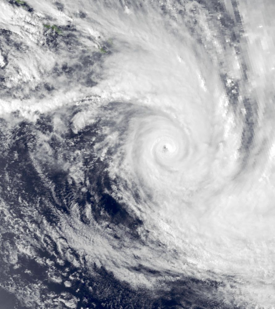
Hurricanes are just God going bowling. He lays one down and that cyclone travels across the ocean right up that bowling alley through the Caribbean and smack dab right into MagaLago but he keeps missing because he's just old so he's gotta try again and hopefully, he'll get it right. Bye bye MagaLago

0
ILianlivingston.bsky.social

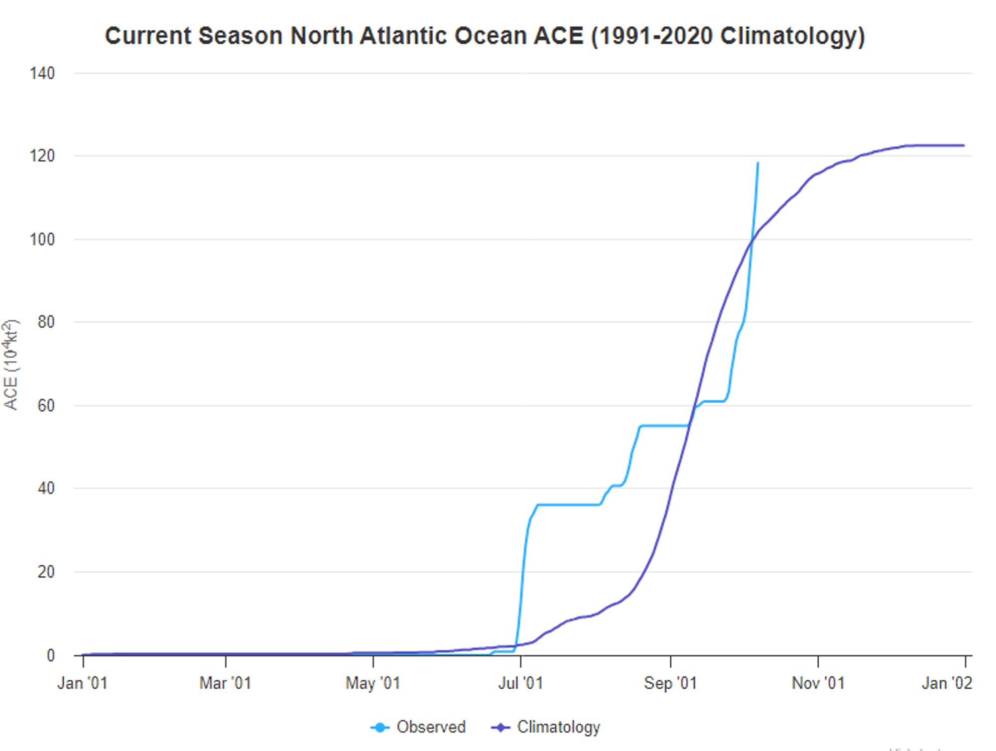
Today could be "hurricane season cancel" cancel day. Accumulated Cyclone Energy about to surpass annual average as of yesterday.

ACE is fun for you and me. There are two lines. Both go up. One is more jagged up that's this year which is currently all up.
1