BLUE

Good evening

0
AFilm.nws-bot.us

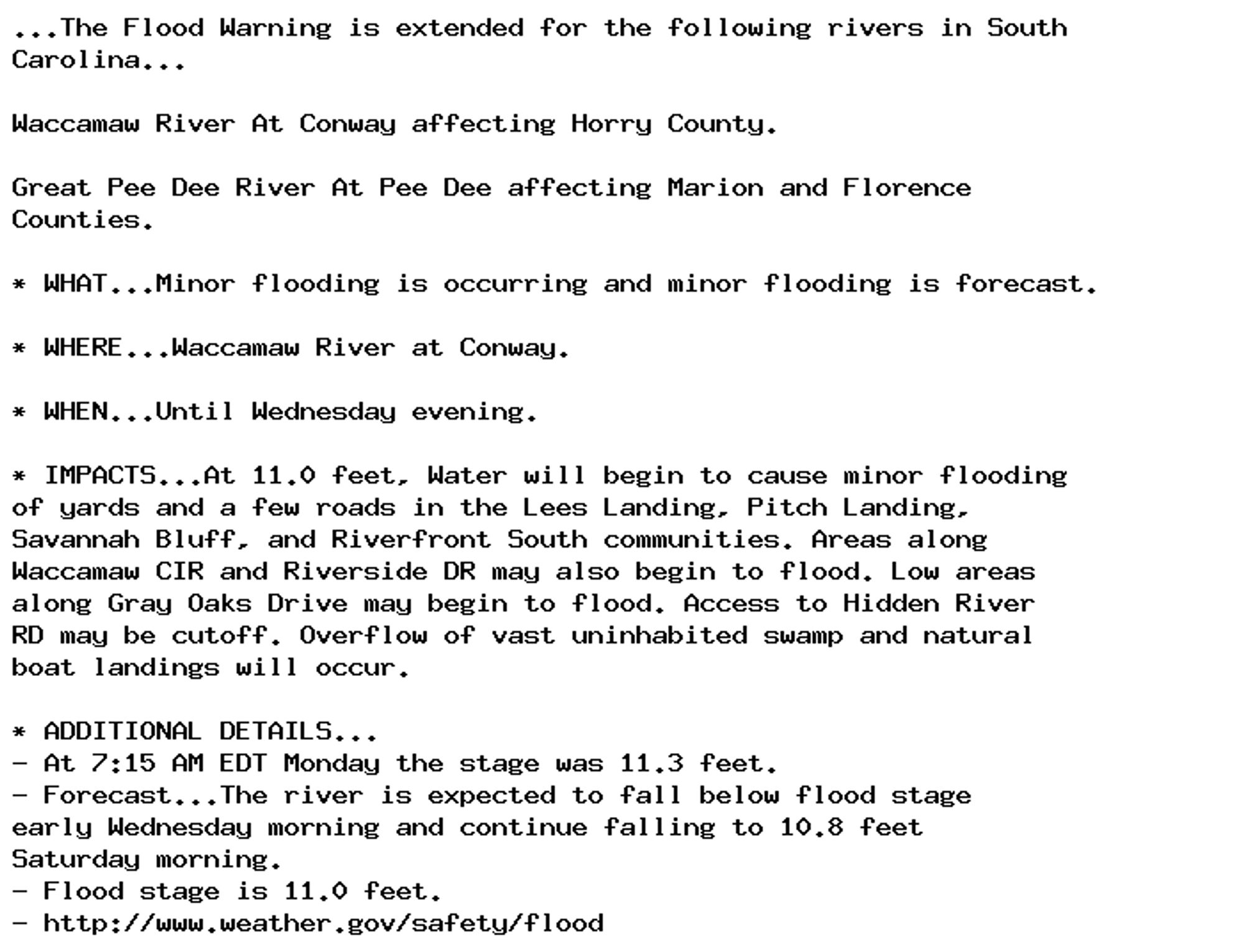
🚨 Flood Warning issued October 7 at 9:16AM EDT until October 10 at 4:00PM EDT by NWS Wilmington NC 🚨 Additional Details Here.

...The Flood Warning is extended for the following rivers in South
Carolina...

Waccamaw River At Conway affecting Horry County.

Great Pee Dee River At Pee Dee affecting Marion and Florence
Counties.

* WHAT...Minor flooding is occurring and minor flooding is forecast.

* WHERE...Great Pee Dee River at Pee Dee.

* WHEN...Until Thursday afternoon.

* IMPACTS...At 20.0 feet, Flood waters will affect swamplands and
logging interests. Flood waters will affect timberland as far
downstream as Yauhannah two weeks after the crest passes Pee Dee.
Logging equipment needs to be moved.

* ADDITIONAL DETAILS...
- At 9:00 AM EDT Monday the stage was 20.9 feet.
- Forecast...The river is expected to fall below flood stage
late Wednesday evening and continue falling to 16.8 feet
Saturday morning.
- Flood stage is 19.0 feet.
- http://www.weather.gov/safety/flood
0
AFilm.nws-bot.us

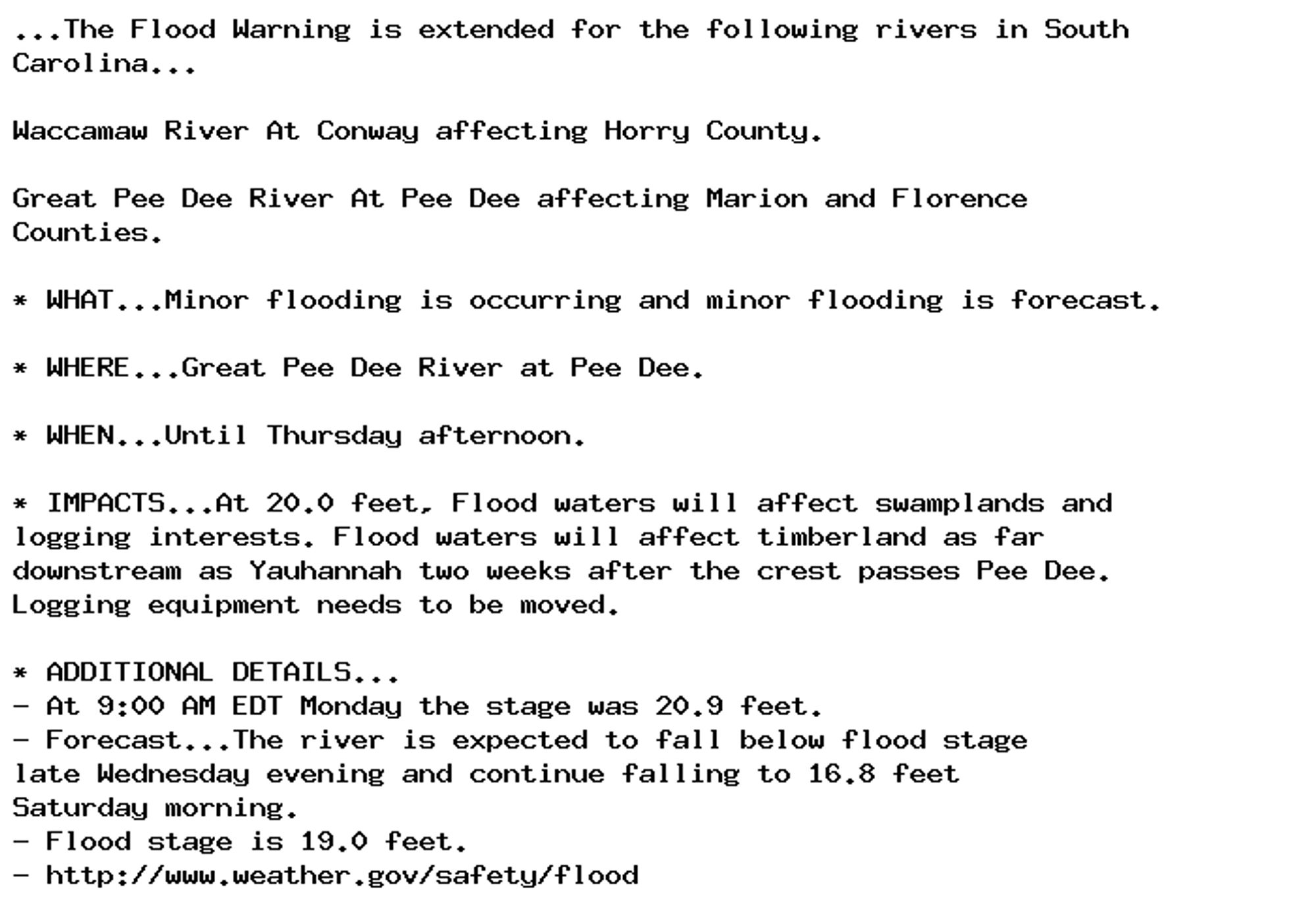
🚨 Flood Warning issued October 7 at 9:16AM EDT until October 9 at 8:00PM EDT by NWS Wilmington NC 🚨 Additional Details Here.

...The Flood Warning is extended for the following rivers in South
Carolina...

Waccamaw River At Conway affecting Horry County.

Great Pee Dee River At Pee Dee affecting Marion and Florence
Counties.

* WHAT...Minor flooding is occurring and minor flooding is forecast.

* WHERE...Waccamaw River at Conway.

* WHEN...Until Wednesday evening.

* IMPACTS...At 11.0 feet, Water will begin to cause minor flooding
of yards and a few roads in the Lees Landing, Pitch Landing,
Savannah Bluff, and Riverfront South communities. Areas along
Waccamaw CIR and Riverside DR may also begin to flood. Low areas
along Gray Oaks Drive may begin to flood. Access to Hidden River
RD may be cutoff. Overflow of vast uninhabited swamp and natural
boat landings will occur.

* ADDITIONAL DETAILS...
- At 7:15 AM EDT Monday the stage was 11.3 feet.
- Forecast...The river is expected to fall below flood stage
early Wednesday morning and continue falling to 10.8 feet
Saturday morning.
- Flood stage is 11.0 feet.
- http://www.weather.gov/safety/flood
0
ETevansthecrime.bsky.social

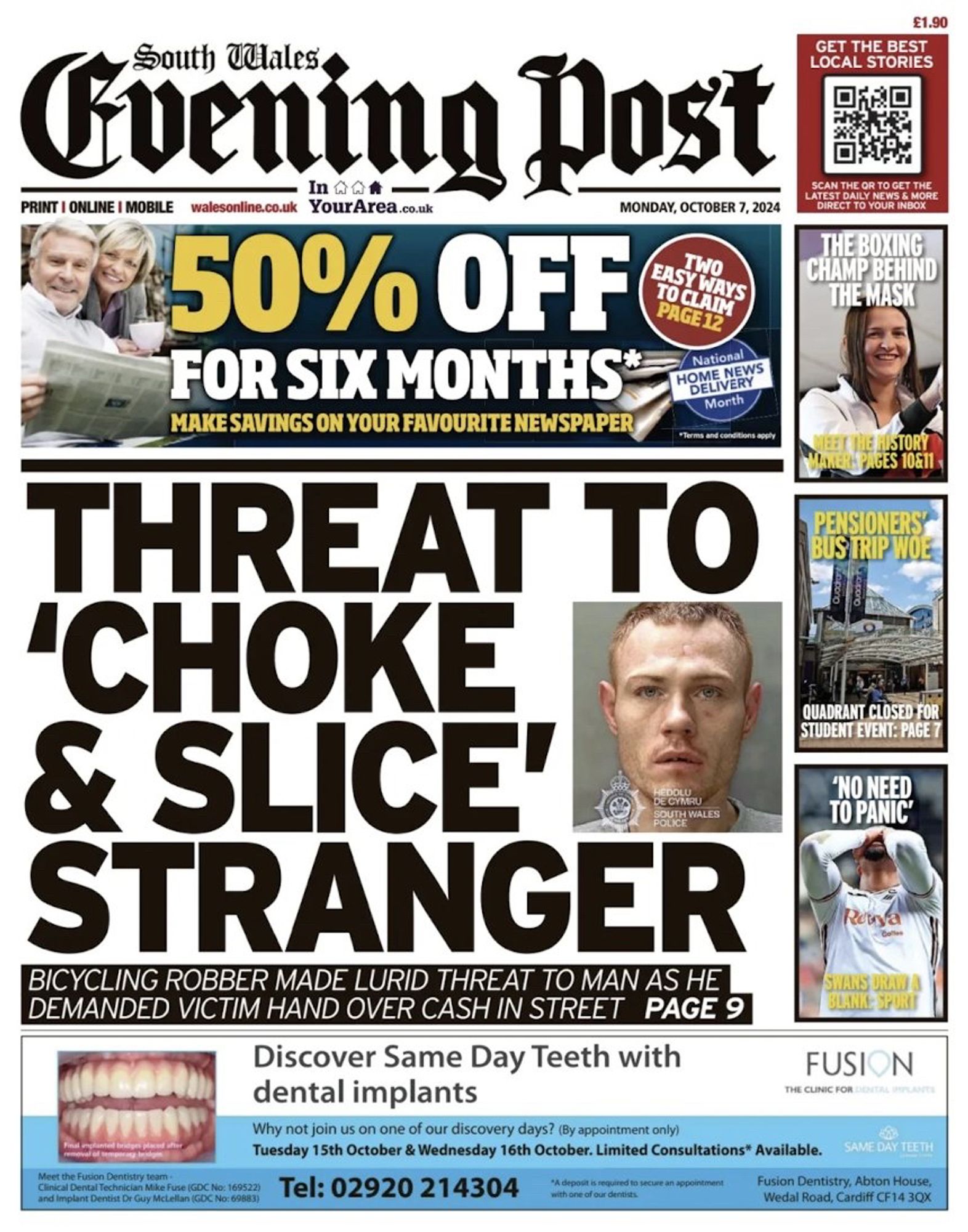
Monday’s South Wales Evening Post - A robber grabbed a man around the neck near Swansea / Abertawe railway station and threatened to “choke and slice” him unless he handed over his cash.

Front page of the South Wales Evening Post newspaper. Headline reads “Threat to ‘choke and slice’ stranger”
0
AForf.nws-bot.us

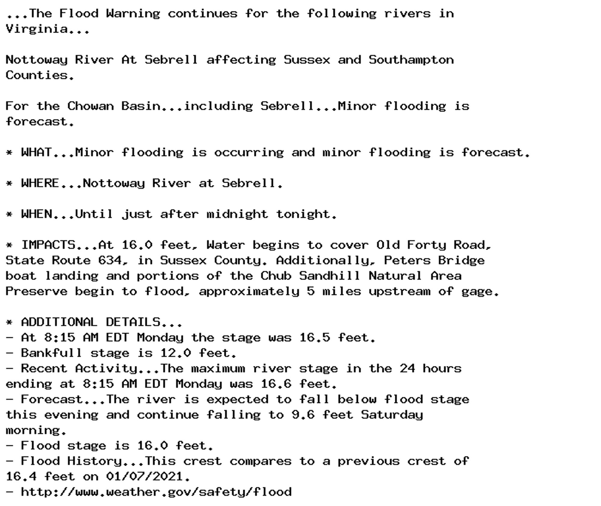
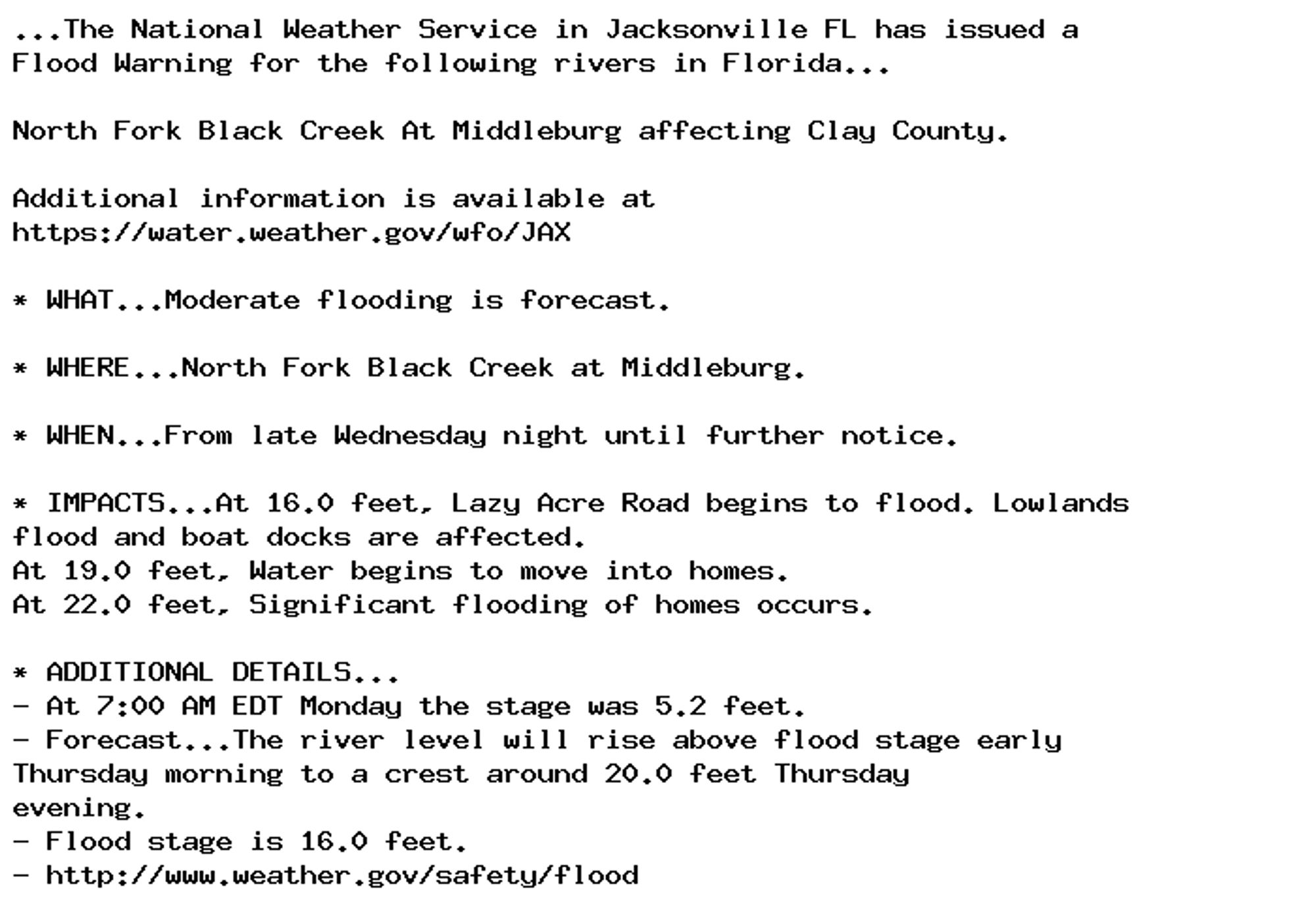
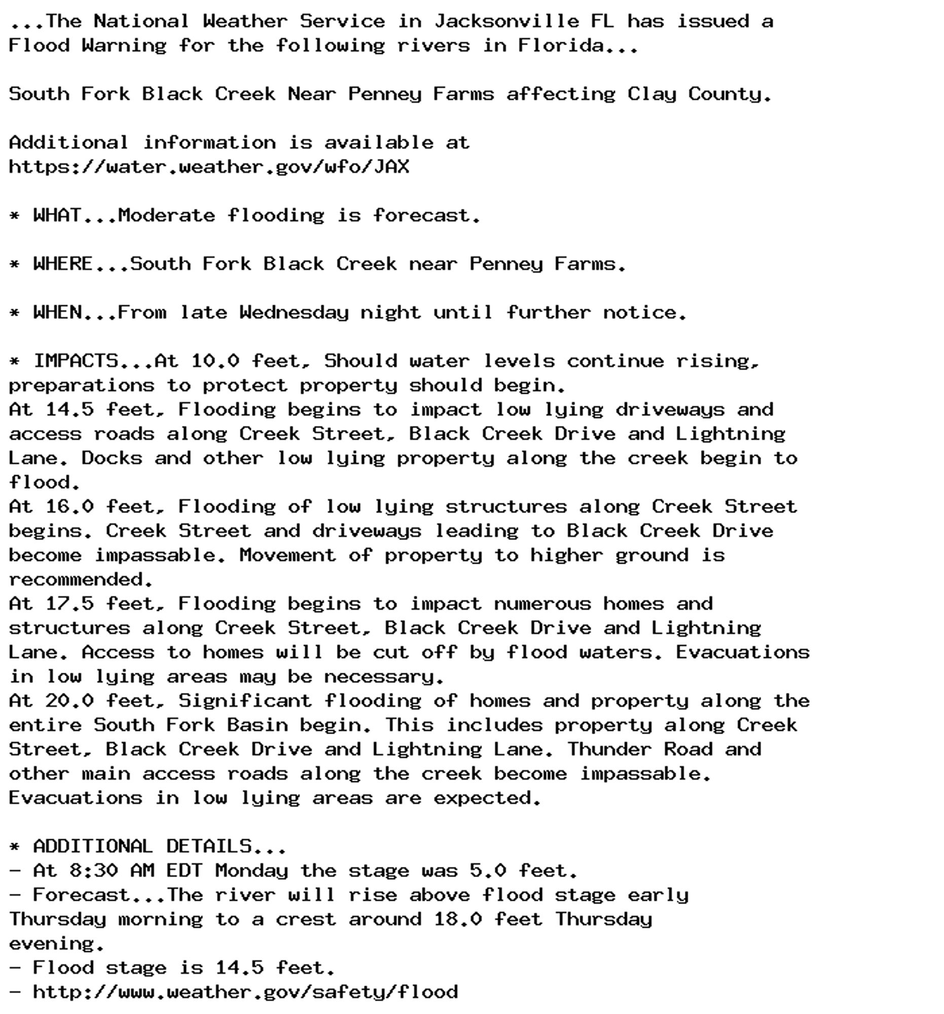
🚨 Flood Warning issued October 7 at 9:25AM EDT until October 8 at 12:30AM EDT by NWS Wakefield VA 🚨 Additional Details Here.

...The Flood Warning continues for the following rivers in
Virginia...

Nottoway River At Sebrell affecting Sussex and Southampton
Counties.

For the Chowan Basin...including Sebrell...Minor flooding is
forecast.

* WHAT...Minor flooding is occurring and minor flooding is forecast.

* WHERE...Nottoway River at Sebrell.

* WHEN...Until just after midnight tonight.

* IMPACTS...At 16.0 feet, Water begins to cover Old Forty Road,
State Route 634, in Sussex County. Additionally, Peters Bridge
boat landing and portions of the Chub Sandhill Natural Area
Preserve begin to flood, approximately 5 miles upstream of gage.

* ADDITIONAL DETAILS...
- At 8:15 AM EDT Monday the stage was 16.5 feet.
- Bankfull stage is 12.0 feet.
- Recent Activity...The maximum river stage in the 24 hours
ending at 8:15 AM EDT Monday was 16.6 feet.
- Forecast...The river is expected to fall below flood stage
this evening and continue falling to 9.6 feet Saturday
morning.
- Flood stage is 16.0 feet.
- Flood History...This crest compares to a previous crest of
16.4 feet on 01/07/2021.
- http://www.weather.gov/safety/flood
0
rednaxelaateir.bsky.social

Good Evening World. Wishing you all a wonderful night....

0
AFjax.nws-bot.us

🚨 Flood Warning issued October 7 at 9:09AM EDT by NWS Jacksonville FL 🚨 Additional Details Here.

...The National Weather Service in Jacksonville FL has issued a
Flood Warning for the following rivers in Florida...

North Fork Black Creek At Middleburg affecting Clay County.

Additional information is available at
https://water.weather.gov/wfo/JAX

* WHAT...Moderate flooding is forecast.

* WHERE...North Fork Black Creek at Middleburg.

* WHEN...From late Wednesday night until further notice.

* IMPACTS...At 16.0 feet, Lazy Acre Road begins to flood. Lowlands
flood and boat docks are affected.
At 19.0 feet, Water begins to move into homes.
At 22.0 feet, Significant flooding of homes occurs.

* ADDITIONAL DETAILS...
- At 7:00 AM EDT Monday the stage was 5.2 feet.
- Forecast...The river level will rise above flood stage early
Thursday morning to a crest around 20.0 feet Thursday
evening.
- Flood stage is 16.0 feet.
- http://www.weather.gov/safety/flood
0
AFjax.nws-bot.us

🚨 Flood Warning issued October 7 at 9:12AM EDT by NWS Jacksonville FL 🚨 Additional Details Here.

...The National Weather Service in Jacksonville FL has issued a
Flood Warning for the following rivers in Florida...

South Fork Black Creek Near Penney Farms affecting Clay County.

Additional information is available at
https://water.weather.gov/wfo/JAX

* WHAT...Moderate flooding is forecast.

* WHERE...South Fork Black Creek near Penney Farms.

* WHEN...From late Wednesday night until further notice.

* IMPACTS...At 10.0 feet, Should water levels continue rising,
preparations to protect property should begin.
At 14.5 feet, Flooding begins to impact low lying driveways and
access roads along Creek Street, Black Creek Drive and Lightning
Lane. Docks and other low lying property along the creek begin to
flood.
At 16.0 feet, Flooding of low lying structures along Creek Street
begins. Creek Street and driveways leading to Black Creek Drive
become impassable. Movement of property to higher ground is
recommended.
At 17.5 feet, Flooding begins to impact numerous homes and
structures along Creek Street, Black Creek Drive and Lightning
Lane. Access to homes will be cut off by flood waters. Evacuations
in low lying areas may be necessary.
At 20.0 feet, Significant flooding of homes and property along the
entire South Fork Basin begin. This includes property along Creek
Street, Black Creek Drive and Lightning Lane. Thunder Road and
other main access roads along the creek become impassable.
Evacuations in low lying areas are expected.

* ADDITIONAL DETAILS...
- At 8:30 AM EDT Monday the stage was 5.0 feet.
- Forecast...The river will rise above flood stage early
Thursday morning to a crest around 18.0 feet Thursday
evening.
- Flood stage is 14.5 feet.
- http://www.weather.gov/safety/flood
0
abbackyne.bsky.social

ニュース配信をご覧頂きありがとうございました。アーカイブはこちら(*´ω`*) #CNN#BreakingNews#EveningNews#まぐ船員日誌#まぐ兄弟www.youtube.com/live/qRDNx7K... @YouTubeより

0