BLUE
Ccinepre.com

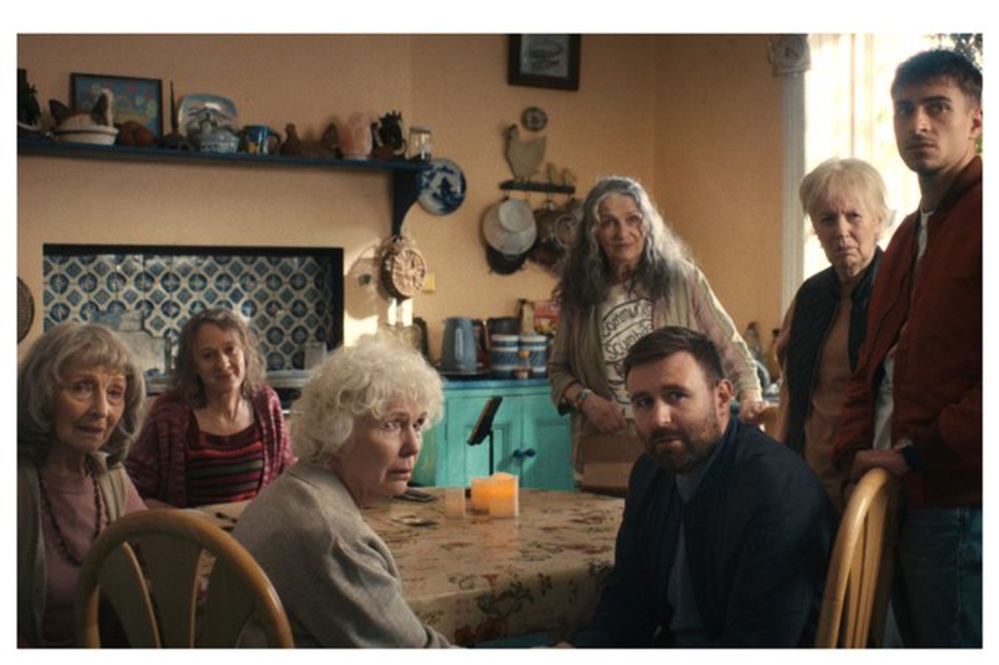
Darren Thornton監督、James McArdle、Fionnula Flanagan、Dearbhla Molloy、Paddy Glynn、Stella McCusker共演"Four Mothers"の映像が公開されたようだ。 deadline.com/video/four-m... (Deadline)

0
MFmerseymal.com

The Playbirds next, featuring Mary Millington, Dudley Sutton, Glynn Edwards, Windsor Davies and....Gavin "That's Life" Campbell?

0
DKdkeefe.bsky.social

Looking to add another resource to your OSINT toolbox? Griffin Glynn wrote a great post on using the social media platform "Threads". Learn how it can help you when Instagram can't. ---> hatless1der.com/threads-net-...#OSINT#SOCMINT#PIVOT

0
Lfvspencelle.bsky.social

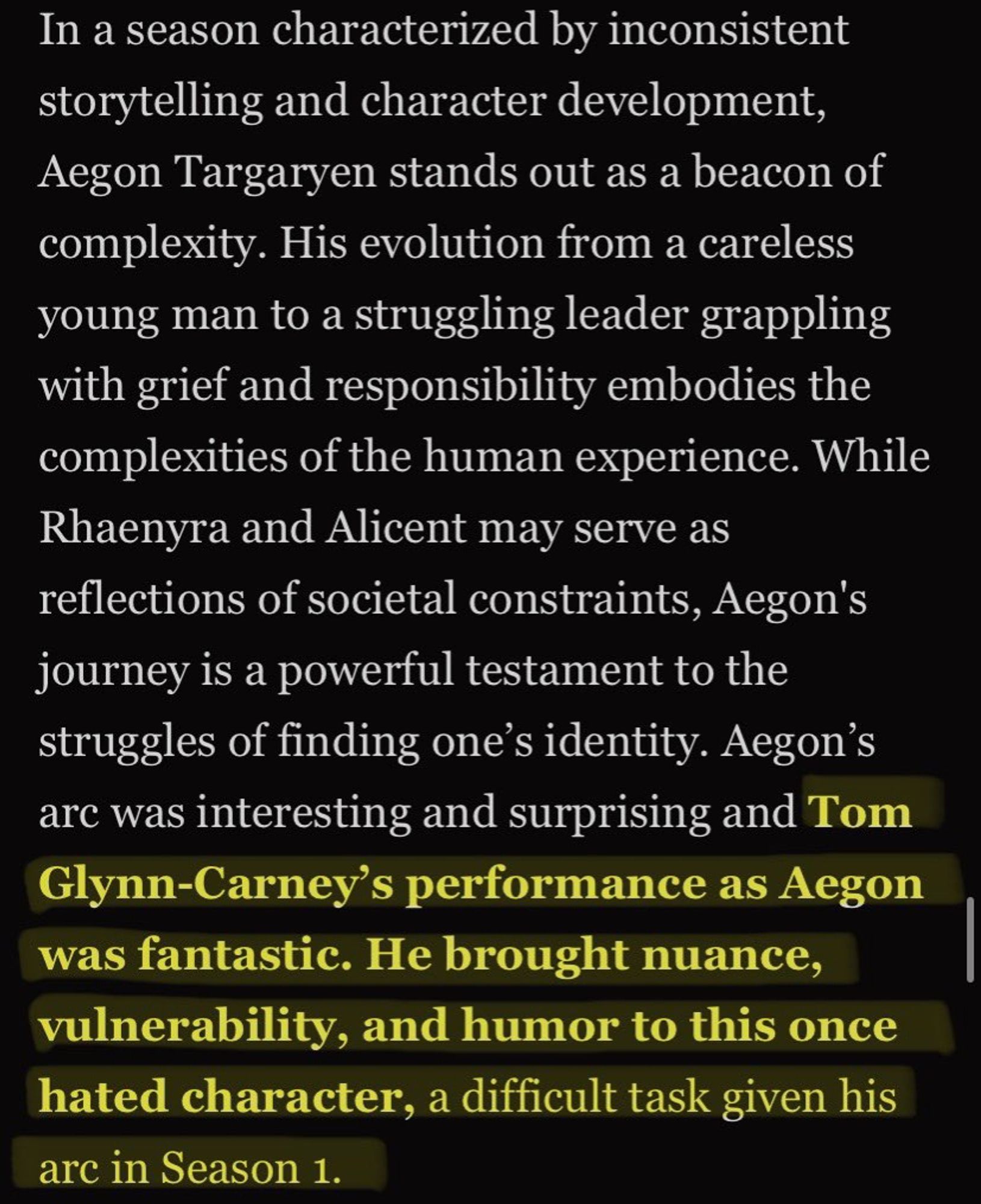
a s2 acabou tem dois meses e tom glynn carney continua sendo elogiado podem continuar espumando a vontadekkkkk

0
AFjax.nws-bot.us

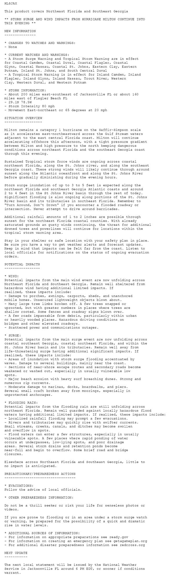
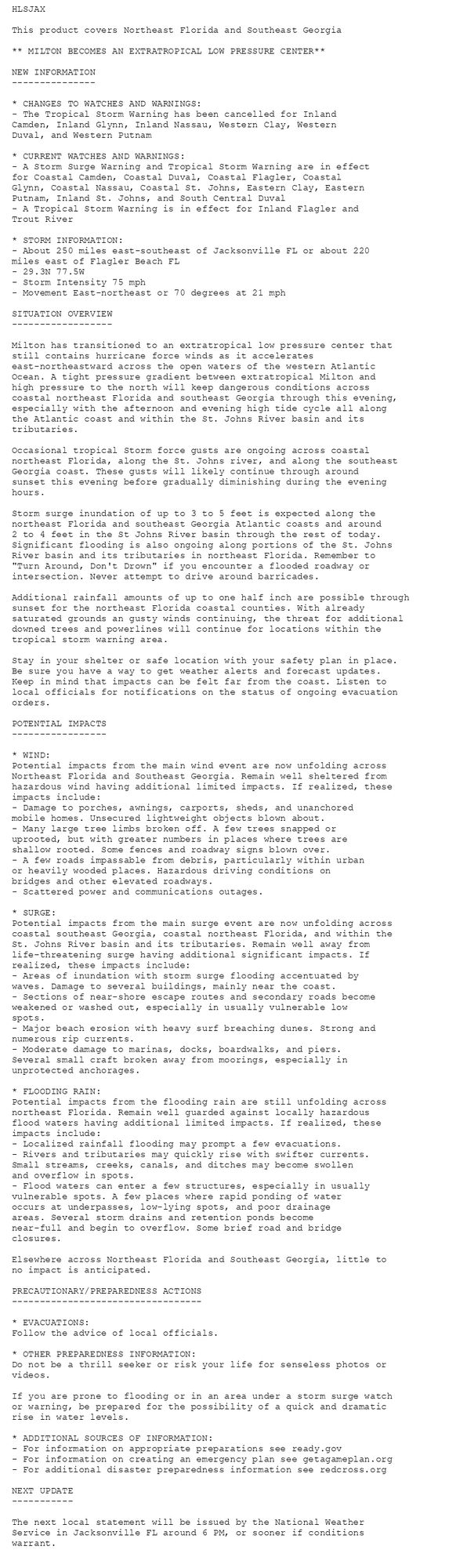
Tropical Cyclone Statement issued October 10 at 2:11PM EDT by NWS Jacksonville FL Additional Details Here.

HLSJAX

This product covers Northeast Florida and Southeast Georgia

** MILTON BECOMES AN EXTRATROPICAL LOW PRESSURE CENTER**

NEW INFORMATION
---------------

* CHANGES TO WATCHES AND WARNINGS:
- The Tropical Storm Warning has been cancelled for Inland
Camden, Inland Glynn, Inland Nassau, Western Clay, Western
Duval, and Western Putnam

* CURRENT WATCHES AND WARNINGS:
- A Storm Surge Warning and Tropical Storm Warning are in effect
for Coastal Camden, Coastal Duval, Coastal Flagler, Coastal
Glynn, Coastal Nassau, Coastal St. Johns, Eastern Clay, Eastern
Putnam, Inland St. Johns, and South Central Duval
- A Tropical Storm Warning is in effect for Inland Flagler and
Trout River

* STORM INFORMATION:
- About 250 miles east-southeast of Jacksonville FL or about 220
miles east of Flagler Beach FL
- 29.3N 77.5W
- Storm Intensity 75 mph
- Movement East-northeast or 70 degrees at 21 mph

SITUATION OVERVIEW
------------------

Milton has transitioned to an extratropical low pressure center that
still contains hurricane force winds as it accelerates
east-northeastward across the open waters of the western Atlantic
Ocean. A tight pressure gradient between extratropical Milton and
high pressure to the north will keep dangerous conditions across
coastal northeast Florida and southeast Georgia through this evening,
especially with the afternoon and evening high tide cycle all along
the Atlantic coast and within the St. Johns River basin and its
tributaries.

Occasional tropical Storm force gusts are ongoing across coastal
northeast Florida, along the St. Johns river, and along the southeast
Georgia coast. These gusts will likely continue through around
sunset this evening before gradually diminishing during the evening
hours.

Storm surge inundation of up to 3 to 5 feet is expected along the
northeast Florida and southeast Georgia Atlantic coasts and around
2 to 4 feet in the St Johns River basin through the rest of today.
Significant flooding is also ongoing along portions of the St. Johns
River basin and its tributaries in northeast Florida. Remember to
"Turn Around, Don't Drown" if you encounter a flooded roadway or
intersection. Never attempt to drive around barricades.

Additional rainfall amounts of up to one half inch are possible through
sunset for the northeast Florida coastal counties. With already
saturated grounds an gusty winds continuing, the threat for additional
downed trees and powerlines will continue for locations within the
tropical storm warning area.

Stay in your shelter or safe location with your safety plan in place.
Be sure you have a way to get weather alerts and forecast updates.
Keep in mind that impacts can be felt far from the coast. Listen to
local officials for notifications on the status of ongoing evacuation
orders.

POTENTIAL IMPACTS
-----------------

* WIND:
Potential impacts from the main wind event are now unfolding across
Northeast Florida and Southeast Georgia. Remain well sheltered from
hazardous wind having additional limited impacts. If realized, these
impacts include:
- Damage to porches, awnings, carports, sheds, and unanchored
mobile homes. Unsecured lightweight objects blown about.
- Many large tree limbs broken off. A few trees snapped or
uprooted, but with greater numbers in places where trees are
shallow rooted. Some fences and roadway signs blown over.
- A few roads impassable from debris, particularly within urban
or heavily wooded places. Hazardous driving conditions on
bridges and other elevated roadways.
- Scattered power and communications outages.

* SURGE:
Potential impacts from the main surge event are now unfolding across
coastal southeast Georgia, coastal northeast Florida, and within the
St. Johns River basin and its tributaries. Remain well away from
life-threatening surge having additional significant impacts. If
realized, these impacts include:
- Areas of inundation with storm surge flooding accentuated by
waves. Damage to several buildings, mainly near the coast.
- Sections of near-shore escape routes and secondary roads become
weakened or washed out, especially in usually vulnerable low
spots.
- Major beach erosion with heavy surf breaching dunes. Strong and
numerous rip currents.
- Moderate damage to marinas, docks, boardwalks, and piers.
Several small craft broken away from moorings, especially in
unprotected anchorages.

* FLOODING RAIN:
Potential impacts from the flooding rain are still unfolding across
northeast Florida. Remain well guarded against locally hazardous
flood waters having additional limited impacts. If realized, these
impacts include:
- Localized rainfall flooding may prompt a few evacuations.
- Rivers and tributaries may quickly rise with swifter currents.
Small streams, creeks, canals, and ditches may become swollen
and overflow in spots.
- Flood waters can enter a few structures, especially in usually
vulnerable spots. A few places where rapid ponding of water
occurs at underpasses, low-lying spots, and poor drainage
areas. Several storm drains and retention ponds become
near-full and begin to overflow. Some brief road and bridge
closures.

Elsewhere across Northeast Florida and Southeast Georgia, little to
no impact is anticipated.

PRECAUTIONARY/PREPAREDNESS ACTIONS
----------------------------------

* EVACUATIONS:
Follow the advice of local officials.

* OTHER PREPAREDNESS INFORMATION:
Do not be a thrill seeker or risk your life for senseless photos or
videos.

If you are prone to flooding or in an area under a storm surge watch
or warning, be prepared for the possibility of a quick and dramatic
rise in water levels.

* ADDITIONAL SOURCES OF INFORMATION:
- For information on appropriate preparations see ready.gov
- For information on creating an emergency plan see getagameplan.org
- For additional disaster preparedness information see redcross.org

NEXT UPDATE
-----------

The next local statement will be issued by the National Weather
Service in Jacksonville FL around 6 PM, or sooner if conditions
warrant.
0
AFjax.nws-bot.us

🚨🚨🚨 Storm Surge Warning issued October 10 at 1:56PM EDT by NWS Jacksonville FL 🚨🚨🚨 Additional Details Here.(6/6)

* LOCATIONS AFFECTED
- Jekyll Island
- Glynn Haven
- Sea Island
- St. Simons
- Country Club Estate
- Dock Junction

* WIND
- LATEST LOCAL FORECAST: Below tropical storm force wind
- Peak Wind Forecast: 20-30 mph with gusts to 40 mph

- THREAT TO LIFE AND PROPERTY THAT INCLUDES TYPICAL FORECAST
UNCERTAINTY IN TRACK, SIZE AND INTENSITY: Potential for wind 39
to 57 mph
- The wind threat has remained nearly steady from the
previous assessment.
- PLAN: The sustained wind should remain less than tropical
storm force. Conditions may still be gusty.
- PREPARE: Listen for any instructions from local officials.
- ACT: Ensure emergency readiness should the forecast change.

- REALIZED IMPACTS: Being Assessed
- Little to no additional wind impacts expected. Community
officials are now assessing the extent of actual wind
impacts accordingly.

* STORM SURGE
- LATEST LOCAL FORECAST: Life-threatening storm surge possible
- Peak Storm Surge Inundation: The potential for 3-5 feet
above ground somewhere within surge prone areas
- Window of concern: through Friday morning

- THREAT TO LIFE AND PROPERTY THAT INCLUDES TYPICAL FORECAST
UNCERTAINTY IN TRACK, SIZE AND INTENSITY: Potential for storm
surge flooding greater than 3 feet above ground
- The storm surge threat has remained nearly steady from the
previous assessment.
- PLAN: Shelter against life-threatening storm surge of
greater than 3 feet above ground.
- PREPARE: Flood preparations and ordered evacuations should
be complete. Evacuees should be in shelters well away from
storm surge flooding.
- ACT: Remain sheltered in a safe location. Do not venture
outside.

- POTENTIAL IMPACTS: Unfolding
- Potential impacts from the main surge event are unfolding.

* FLOODING RAIN
- LATEST LOCAL FORECAST:
- Peak Rainfall Amounts: No additional significant rainfall
forecast

- THREAT TO LIFE AND PROPERTY THAT INCLUDES TYPICAL FORECAST
UNCERTAINTY IN TRACK, SIZE AND INTENSITY: Little or no
potential for flooding rain
- The flooding rain threat has remained nearly steady from
the previous assessment.
- PLAN: There is little or no potential for flooding rain.
- PREPARE: Little to no preparations are needed to protect
against flooding rain at this time.
- ACT: Monitor for changes to the forecast.

- POTENTIAL IMPACTS: Little to None
- Little to no potential impacts from flooding rain.

* TORNADO
- LATEST LOCAL FORECAST:
- Situation is unfavorable for tornadoes

- THREAT TO LIFE AND PROPERTY THAT INCLUDES TYPICAL FORECAST
UNCERTAINTY IN TRACK, SIZE AND INTENSITY: Tornadoes not expected
- The tornado threat has remained nearly steady from the
previous assessment.
- PLAN: Tornadoes are not expected. Showers and thunderstorms
with gusty winds may still occur.
- PREPARE: Little to no preparations needed to protect
against tornadoes at this time. Keep informed of the latest
tornado situation.
- ACT: Listen for changes in the forecast.

- POTENTIAL IMPACTS: Little to None
- Little to no potential impacts from tornadoes.

* FOR MORE INFORMATION:
- Family Emergency Plans (FEMA): http://ready.gov/hurricanes
- Local weather conditions and forecasts: http://www.weather.gov/jax/
0
NWskeetbot.watchedsky.social

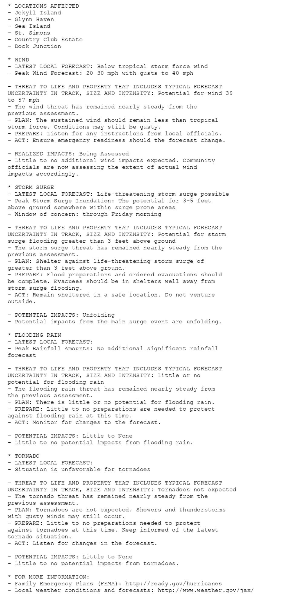
NEW WEATHER ADVISORY: Storm Surge Warning * LOCATIONS AFFECTED - Jekyll Island - Glynn Haven - Sea Island - St. Simons - Country Club Estate - Dock Junction * WIND - LATEST LOCAL FORECAST: Below tropical storm force wind - Peak Wind Forecast: 20-30... See more: watchedsky.social/app/alerts/...

0
NWskeetbot.watchedsky.social

NEW WEATHER ADVISORY: Tropical Storm Warning * LOCATIONS AFFECTED - Jekyll Island - Glynn Haven - Sea Island - St. Simons - Country Club Estate - Dock Junction * WIND - LATEST LOCAL FORECAST: Below tropical storm force wind - Peak Wind Forecast:... See more: watchedsky.social/app/alerts/...

0
NWskeetbot.watchedsky.social

NEW WEATHER ADVISORY: Wind Advisory * WHAT...North winds 15 to 25 mph with gusts up to 40 mph. * WHERE...In Florida, Inland Nassau, Western Clay, Western Duval, and Western Putnam Counties. In Georgia, Inland Camden and Inland Glynn Counties. *... See more: watchedsky.social/app/alerts/...

0
AFjax.nws-bot.us

Tropical Cyclone Statement issued October 10 at 11:04AM EDT by NWS Jacksonville FL Additional Details Here.

HLSJAX

This product covers Northeast Florida and Southeast Georgia

** STORM SURGE AND WIND IMPACTS FROM HURRICANE MILTON CONTINUE INTO
THIS EVENING **

NEW INFORMATION
---------------

* CHANGES TO WATCHES AND WARNINGS:
- None

* CURRENT WATCHES AND WARNINGS:
- A Storm Surge Warning and Tropical Storm Warning are in effect
for Coastal Camden, Coastal Duval, Coastal Flagler, Coastal
Glynn, Coastal Nassau, Coastal St. Johns, Eastern Clay, Eastern
Putnam, Inland St. Johns, and South Central Duval
- A Tropical Storm Warning is in effect for Inland Camden, Inland
Flagler, Inland Glynn, Inland Nassau, Trout River, Western
Clay, Western Duval, and Western Putnam

* STORM INFORMATION:
- About 200 miles east-southeast of Jacksonville FL or about 160
miles east of Flagler Beach FL
- 29.1N 78.5W
- Storm Intensity 80 mph
- Movement East-northeast or 65 degrees at 20 mph

SITUATION OVERVIEW
------------------

Milton remains a category 1 hurricane on the Saffir-Simpson scale
as it accelerates east-northeastward across the Gulf Stream waters
adjacent to the east central Florida coast. Milton will continue
accelerating offshore this afternoon, with a tight pressure gradient
between Milton and high pressure to the north keeping dangerous
conditions across northeast Florida and the southeast Georgia coast
through this evening.

Sustained Tropical storm force winds are ongoing across coastal
northeast Florida, along the St. Johns river, and along the southeast
Georgia coast. These strong winds will likely continue through around
sunset along the Atlantic oceanfront and along the St. Johns River
before gradually diminishing during the evening hours.

Storm surge inundation of up to 3 to 5 feet is expected along the
northeast Florida and southeast Georgia Atlantic coasts and around
2 to 4 feet in the St Johns River basin through the rest of today.
Significant flooding is also ongoing along portions of the St. Johns
River basin and its tributaries in northeast Florida. Remember to
"Turn Around, Don't Drown" if you encounter a flooded roadway or
intersection. Never attempt to drive around barricades.

Additional rainfall amounts of 1 to 2 inches are possible through
sunset for the northeast Florida coastal counties. With already
saturated grounds an gusty winds continuing, the threat for additional
downed trees and powerlines will continue for locations within the
tropical storm warning area.

Stay in your shelter or safe location with your safety plan in place.
Be sure you have a way to get weather alerts and forecast updates.
Keep in mind that impacts can be felt far from the coast. Listen to
local officials for notifications on the status of ongoing evacuation
orders.

POTENTIAL IMPACTS
-----------------

* WIND:
Potential impacts from the main wind event are now unfolding across
Northeast Florida and Southeast Georgia. Remain well sheltered from
hazardous wind having additional limited impacts. If
realized, these impacts include:
- Damage to porches, awnings, carports, sheds, and unanchored
mobile homes. Unsecured lightweight objects blown about.
- Many large tree limbs broken off. A few trees snapped or
uprooted, but with greater numbers in places where trees are
shallow rooted. Some fences and roadway signs blown over.
- A few roads impassable from debris, particularly within urban
or heavily wooded places. Hazardous driving conditions on
bridges and other elevated roadways.
- Scattered power and communications outages.

* SURGE:
Potential impacts from the main surge event are now unfolding across
coastal southeast Georgia, coastal northeast Florida, and within the
St. Johns River basin and its tributaries. Remain well away from
life-threatening surge having additional significant impacts. If
realized, these impacts include:
- Areas of inundation with storm surge flooding accentuated by
waves. Damage to several buildings, mainly near the coast.
- Sections of near-shore escape routes and secondary roads become
weakened or washed out, especially in usually vulnerable low
spots.
- Major beach erosion with heavy surf breaching dunes. Strong and
numerous rip currents.
- Moderate damage to marinas, docks, boardwalks, and piers.
Several small craft broken away from moorings, especially in
unprotected anchorages.

* FLOODING RAIN:
Potential impacts from the flooding rain are still unfolding across
northeast Florida. Remain well guarded against locally hazardous flood
waters having additional limited impacts. If realized, these impacts include:
- Localized rainfall flooding may prompt a few evacuations.
- Rivers and tributaries may quickly rise with swifter currents.
Small streams, creeks, canals, and ditches may become swollen
and overflow in spots.
- Flood waters can enter a few structures, especially in usually
vulnerable spots. A few places where rapid ponding of water
occurs at underpasses, low-lying spots, and poor drainage
areas. Several storm drains and retention ponds become
near-full and begin to overflow. Some brief road and bridge
closures.

Elsewhere across Northeast Florida and Southeast Georgia, little to
no impact is anticipated.

PRECAUTIONARY/PREPAREDNESS ACTIONS
----------------------------------

* EVACUATIONS:
Follow the advice of local officials.

* OTHER PREPAREDNESS INFORMATION:

Do not be a thrill seeker or risk your life for senseless photos or
videos.

If you are prone to flooding or in an area under a storm surge watch
or warning, be prepared for the possibility of a quick and dramatic
rise in water levels.

* ADDITIONAL SOURCES OF INFORMATION:
- For information on appropriate preparations see ready.gov
- For information on creating an emergency plan see getagameplan.org
- For additional disaster preparedness information see redcross.org

NEXT UPDATE
-----------

The next local statement will be issued by the National Weather
Service in Jacksonville FL around 6 PM EDT, or sooner if conditions
warrant.
0