BLUE
BRbbcradio3bot.bsky.social

BBC Radio 3 Essential Classics Now Playing Eric Whitacre, Polyphony & Stephen Layton Sleep

0
AFeyw.nws-bot.us

🚨 Tropical Storm Watch issued October 7 at 5:03AM EDT by NWS Key West FL 🚨 Additional Details Here.

A Tropical Storm Watch means tropical storm-force winds are possible
somewhere within this area within the next 48 hours

* LOCATIONS AFFECTED
- Marathon
- Key Colony Beach
- Layton

* WIND
- LATEST LOCAL FORECAST: Below tropical storm force wind
- Peak Wind Forecast: 15-25 mph with gusts to 30 mph

- THREAT TO LIFE AND PROPERTY THAT INCLUDES TYPICAL FORECAST
UNCERTAINTY IN TRACK, SIZE AND INTENSITY: Potential for wind 39
to 57 mph
- PLAN: Plan for hazardous wind of equivalent tropical storm
force.
- PREPARE: Efforts to protect property should now be
underway. Prepare for limited wind damage.
- ACT: Act now to complete preparations before the wind
becomes hazardous.

- POTENTIAL IMPACTS: Limited
- Damage to porches, awnings, carports, sheds, and unanchored
mobile homes. Unsecured lightweight objects blown about.
- Many large tree limbs broken off. A few trees snapped or
uprooted, but with greater numbers in places where trees
are shallow rooted. Some fences and roadway signs blown
over.
- A few roads impassable from debris, particularly within
urban or heavily wooded places. Hazardous driving
conditions on bridges and other elevated roadways.
- Scattered power and communications outages.

* STORM SURGE
- LATEST LOCAL FORECAST: Localized storm surge possible
- Peak Storm Surge Inundation: The potential for 1-3 feet
above ground somewhere within surge prone areas
- Window of concern: Wednesday morning until Thursday evening

- THREAT TO LIFE AND PROPERTY THAT INCLUDES TYPICAL FORECAST
UNCERTAINTY IN TRACK, SIZE AND INTENSITY: Potential for storm
surge flooding greater than 1 foot above ground
- PLAN: Plan for storm surge flooding greater than 1 foot
above ground.
- PREPARE: Efforts should now be underway to prepare for
storm surge flooding, especially in low-lying vulnerable
areas.
- ACT: Take actions to protect life and property. Prepare to
leave if evacuation orders are given for your area.

- POTENTIAL IMPACTS: Limited
- Localized inundation with storm surge flooding mainly along
immediate shorelines and in low-lying spots, or in areas
farther inland near where higher surge waters move ashore.
- Sections of roads and parking lots inundated by surge
water. Driving conditions dangerous in places where surge
water covers the road.
- Moderate beach erosion.
- Minor to locally moderate damage to marinas, docks,
boardwalks, and piers. A few small craft broken away from
moorings.

* FLOODING RAIN
- LATEST LOCAL FORECAST:
- Peak Rainfall Amounts: Additional 3-6 inches, with locally
higher amounts

- THREAT TO LIFE AND PROPERTY THAT INCLUDES TYPICAL FORECAST
UNCERTAINTY IN TRACK, SIZE AND INTENSITY: Potential for
moderate flooding rain
- PLAN: Emergency plans should include the potential for
moderate flooding from heavy rain. Evacuations and rescues
are possible.
- PREPARE: Consider protective actions if you are in an area
vulnerable to flooding.
- ACT: Heed any flood watches and warnings. Failure to take
action may result in serious injury or loss of life.

- POTENTIAL IMPACTS: Significant
- Moderate rainfall flooding may prompt several evacuations
and rescues.
- Flood waters can enter some structures or weaken
foundations. Several places may experience expanded areas
of rapid inundation at underpasses, low-lying spots, and
poor drainage areas. Some streets and parking lots take on
moving water as storm drains and retention ponds overflow.
Driving conditions become hazardous. Some road and bridge
closures.

* TORNADO
- LATEST LOCAL FORECAST:
- Situation is somewhat favorable for tornadoes

- THREAT TO LIFE AND PROPERTY THAT INCLUDES TYPICAL FORECAST
UNCERTAINTY IN TRACK, SIZE AND INTENSITY: Potential for a few
tornadoes
- PLAN: Emergency plans should include the potential for a
few tornadoes.
- PREPARE: If your shelter is particularly vulnerable to
tornadoes, prepare to relocate to safe shelter before
hazardous weather arrives.
- ACT: If a tornado warning is issued, be ready to shelter
quickly.

- POTENTIAL IMPACTS: Limited
- The occurrence of isolated tornadoes can hinder the
execution of emergency plans during tropical events.
- A few places may experience tornado damage, along with
power and communications disruptions.
- Locations could realize roofs peeled off buildings,
chimneys toppled, mobile homes pushed off foundations or
overturned, large tree tops and branches snapped off,
shallow-rooted trees knocked over, moving vehicles blown
off roads, and small boats pulled from moorings.

* FOR MORE INFORMATION:
- Family emergency plans: Federal Emergency Management Agency
- http://ready.gov/
- Local weather conditions and forecasts: NOAA/Florida Keys National Weather Service
- http://www.weather.gov/key/
0

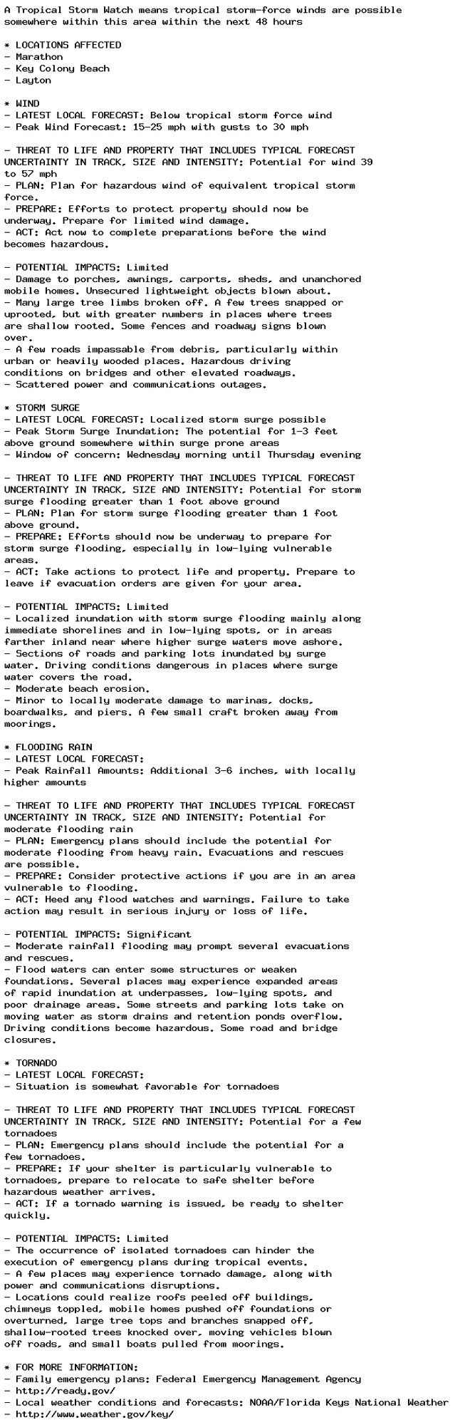
NEW WEATHER ADVISORY: Tropical Storm Watch A Tropical Storm Watch means tropical storm-force winds are possible somewhere within this area within the next 48 hours * LOCATIONS AFFECTED - Marathon - Key Colony Beach - Layton * WIND - LATEST LOCAL... See more: watchedsky.social/app/alerts/...

0
Mdrgoombatower.bsky.social

And i finished watching kat's mistery solving files It was a lot better than i thought it would be It made me cry twice!!!!!!(when kat and layton finally back and in the credits of the last episode)

0
Eenigmaobscurius.bsky.social

Luke in my own style, because why not?? I usualy like to draw Layton characters more closely to the OG style, but I wanted to see how Luke would look like in my own #ProfessorLayton#ProfessorLaytonFanArt

0
Jjulesbilee.bsky.social

got a bunch of professor layton retrospectives suggested on youtube and now I want to replay the games alfkskfksjfjdkl

0
LTprofsmash.bsky.social

Bought a used copy of Professor Layton and the Last Specter. Took a look at the save data. The previous owners name? Satan. Pretty sure this is how creepypastas start.

0
APproplaystowin.bsky.social

Finally finished the first piece genderbent professor layton fanart

0
Sschematikart.bsky.social

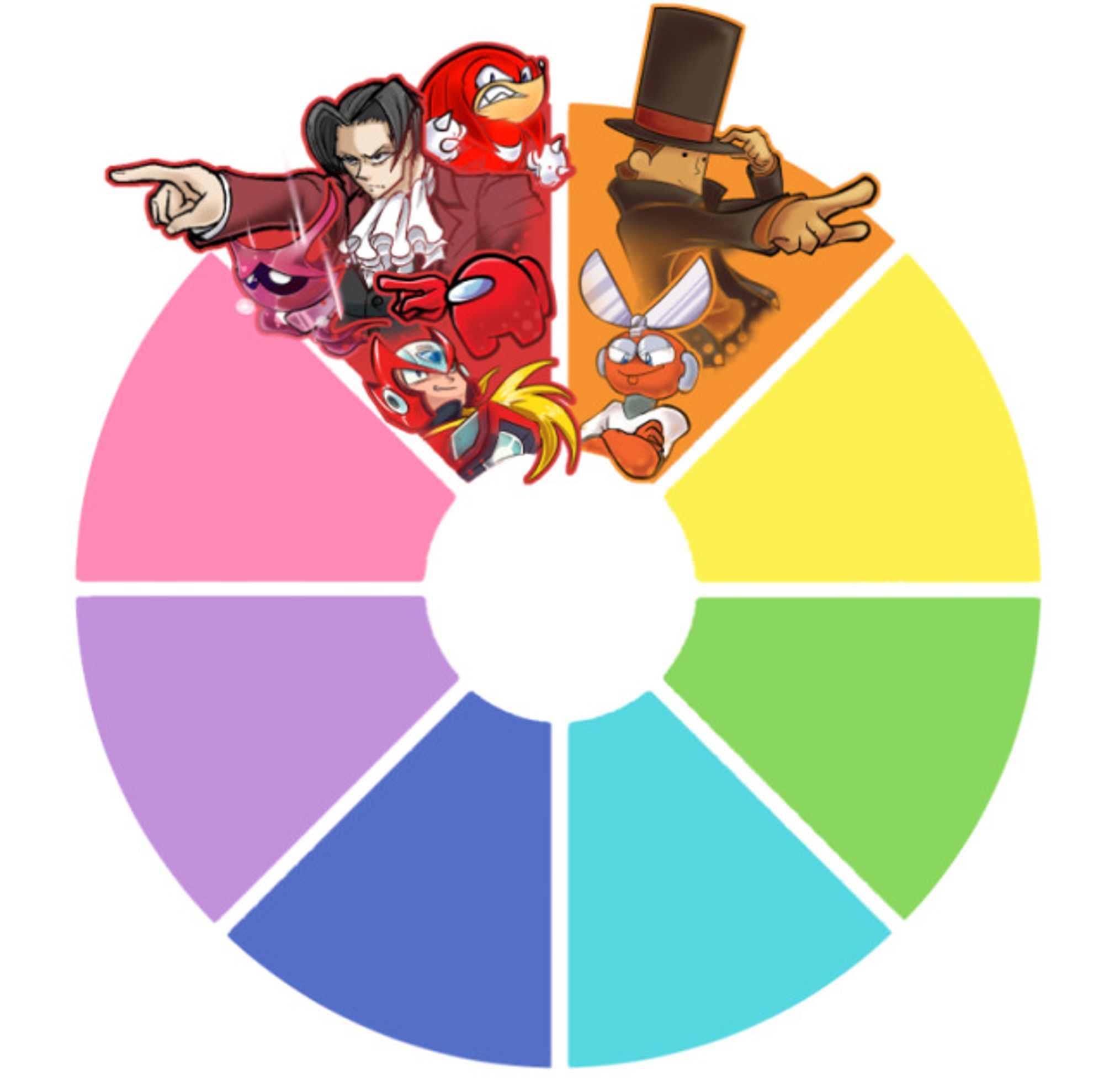
Started a color wheel character challenge and I forgot to share here :P Who else do you wanna see join orange? Lemme know!! #colorwheelchallenge#aceattorney#hollowknight#amongus#sonicthehedgehog#megaman#professorlayton#art#artistonbluesky

Color Wheel Character Art Challenge: A graph divided in 8 different colors, Red, Orange, Yellow, Green, Cyan, Blue, Purple and Pink, with the red slice hosting Miles Edgeworth (Ace Attorney Series), Red Crewmate (Among Us), Xero (Hollow Knight), Knuckles (Sonic the Hedgehog series), and Zero (Megaman X Series), and the orange slice hosting Professor Layton (Professor Layton Series) and Cut Man (Megaman Classic series)
3