BLUE
fish.posting.lol

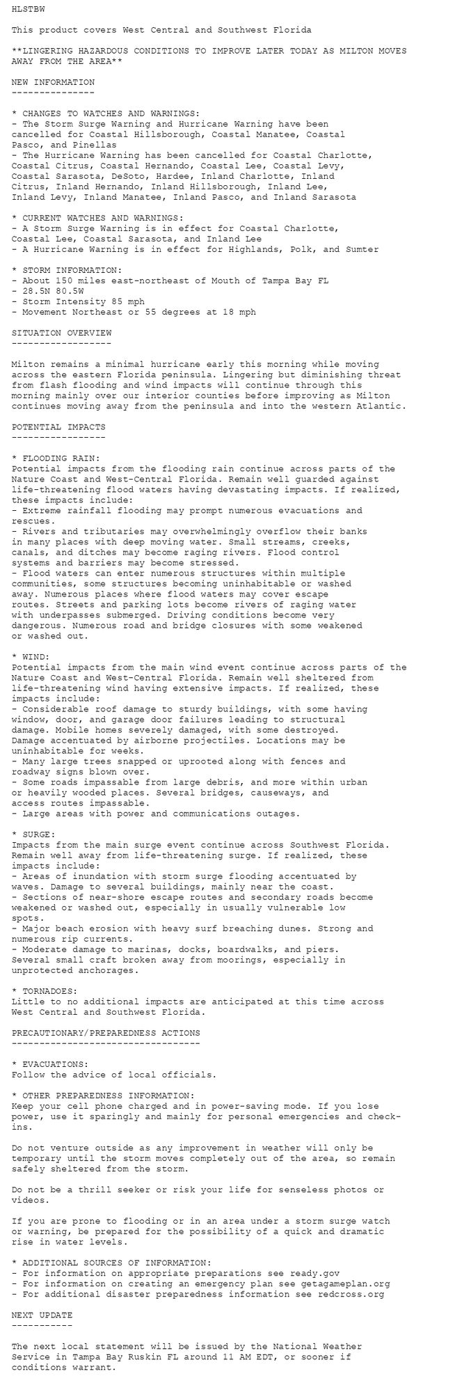
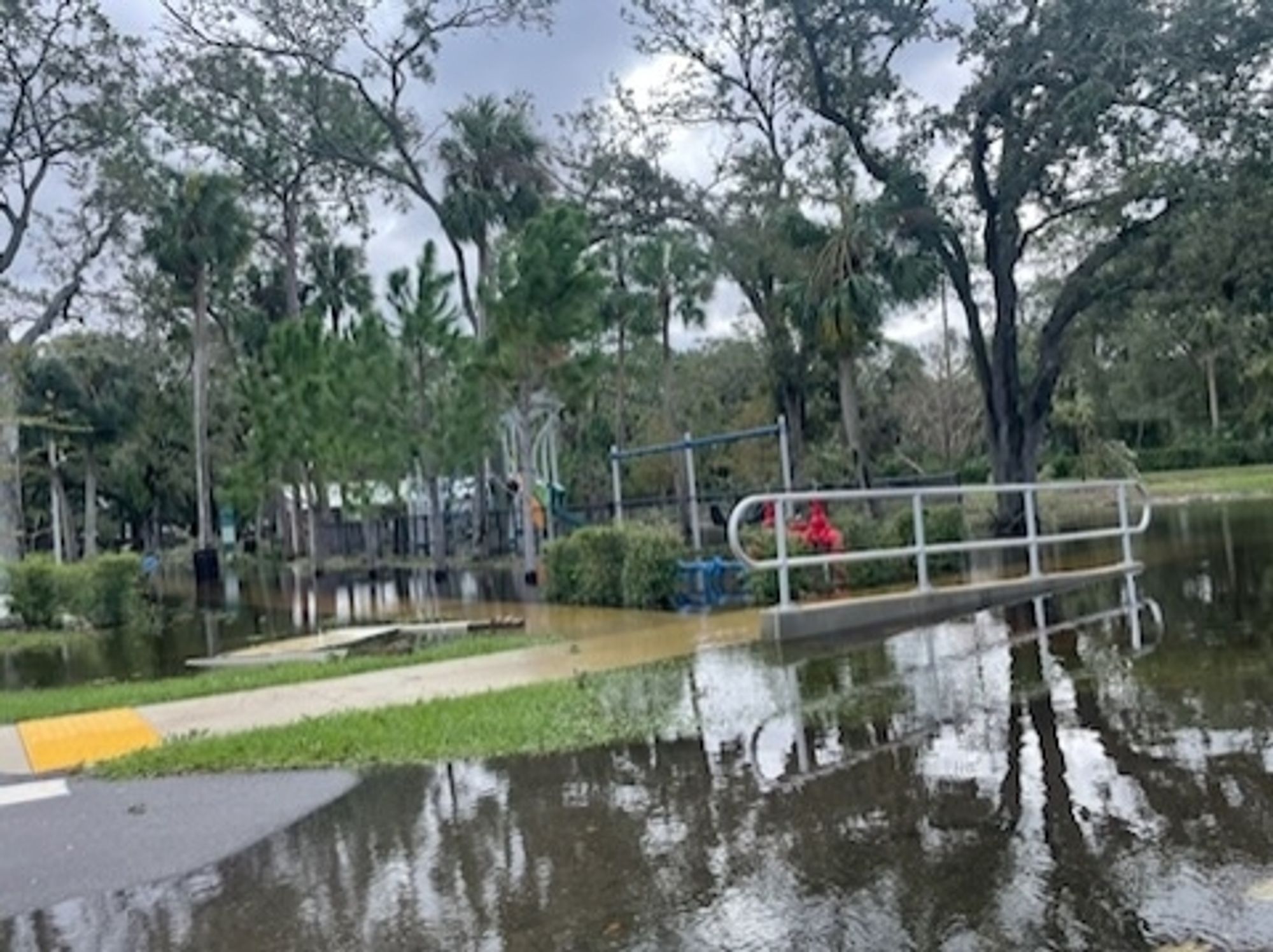
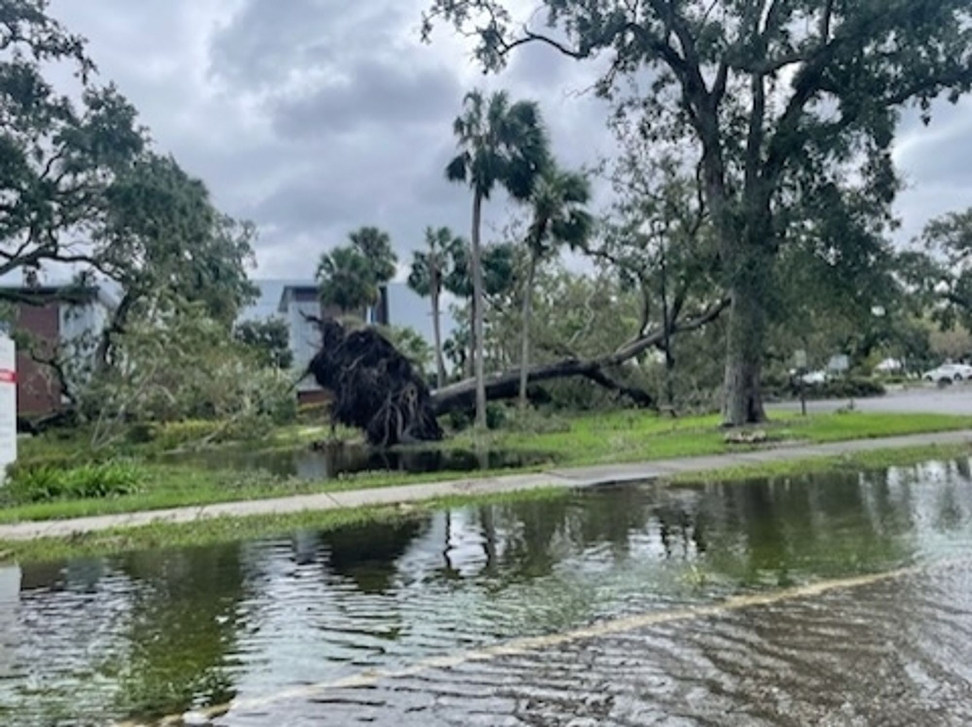
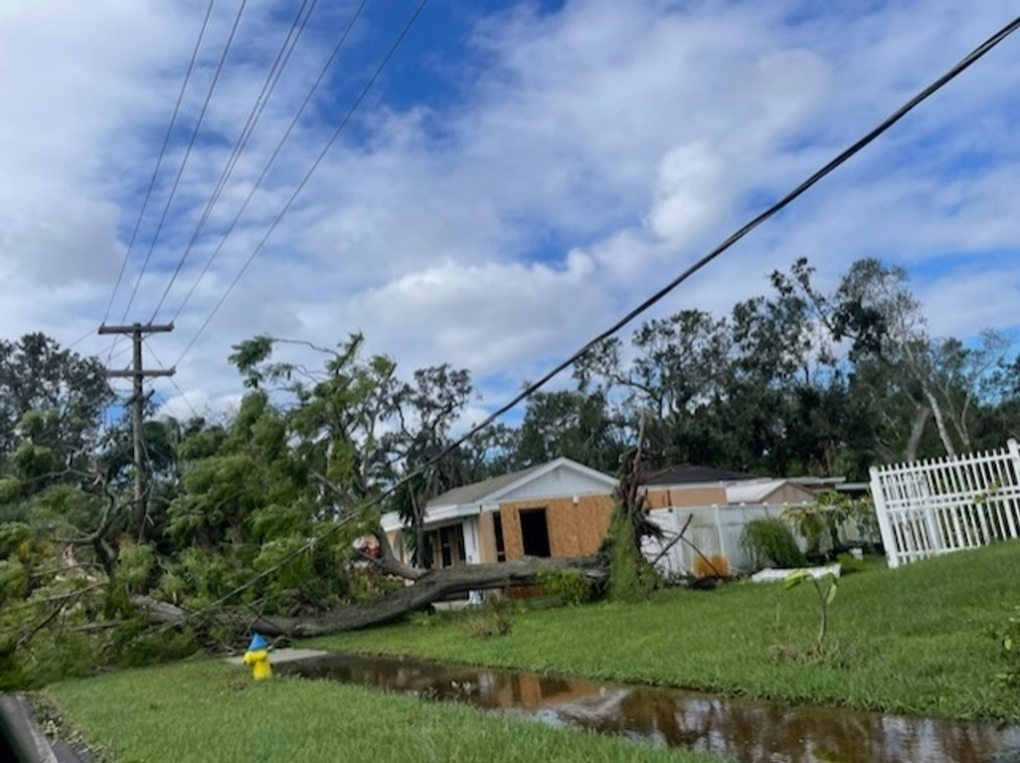
some post milton photos my sister sent me from the town 'n' country area of tampa. her home in the next county over (pinellas) only received minor damage to a fence. she still has power, even. her dental practice here in tampa was also spared from any major damage.

flooded park
downed large trees and a road flooded over the curb
tall trees and a utility pole in a deep puddle of flood water
huge tree fallen on to a power line. the sidewalk is flooded but grass is still visible in the adjacent yard
1
NSnickstarr.com

Still over 400,000 without power in Pinellas County, Florida where I am at 🌀 #HurricaneMiltom#HurricaneMilton#Pinellas#Tampa#Clearwater#Milton#Hurricane#TampaBay#TampaBay

0
NSnickstarr.com

Using generator to keep the fridges and freezers running but still no power in Clearwater. Over 400k in the county still without it. 🌀 #HurricaneMiltom#HurricaneMilton#Pinellas#Tampa#Clearwater#Milton#Hurricane#TampaBay#TampaBay

0
TAaflightybroad.bsky.social

still ended up with 10’ surge in sarasota but pinellas and tampa getting spared is something

0
AFfresnel.bsky.social

Waiting to hear an update from my family in Pinellas county Florida, how are you?

0
AFtpa.nws-bot.us

High Surf Advisory issued October 10 at 8:06AM EDT until October 10 at 11:00PM EDT by NWS Tampa Bay Ruskin FL Additional Details Here.

* WHAT...Dangerous rip currents.

* WHERE...Pinellas, Coastal Hillsborough, Coastal Manatee,
Coastal Sarasota, Coastal Charlotte and Coastal Lee Counties.

* WHEN...Through Friday morning.

* IMPACTS...Rip currents can sweep even the best swimmers away
from shore into deeper water.
* WHAT...Dangerous rip currents.

* WHERE...Pinellas, Coastal Hillsborough, Coastal Manatee,
Coastal Sarasota, Coastal Charlotte and Coastal Lee Counties.

* WHEN...Through Friday morning.

* IMPACTS...Rip currents can sweep even the best swimmers away
from shore into deeper water.
0
BJclimatebrad.hillheat.com

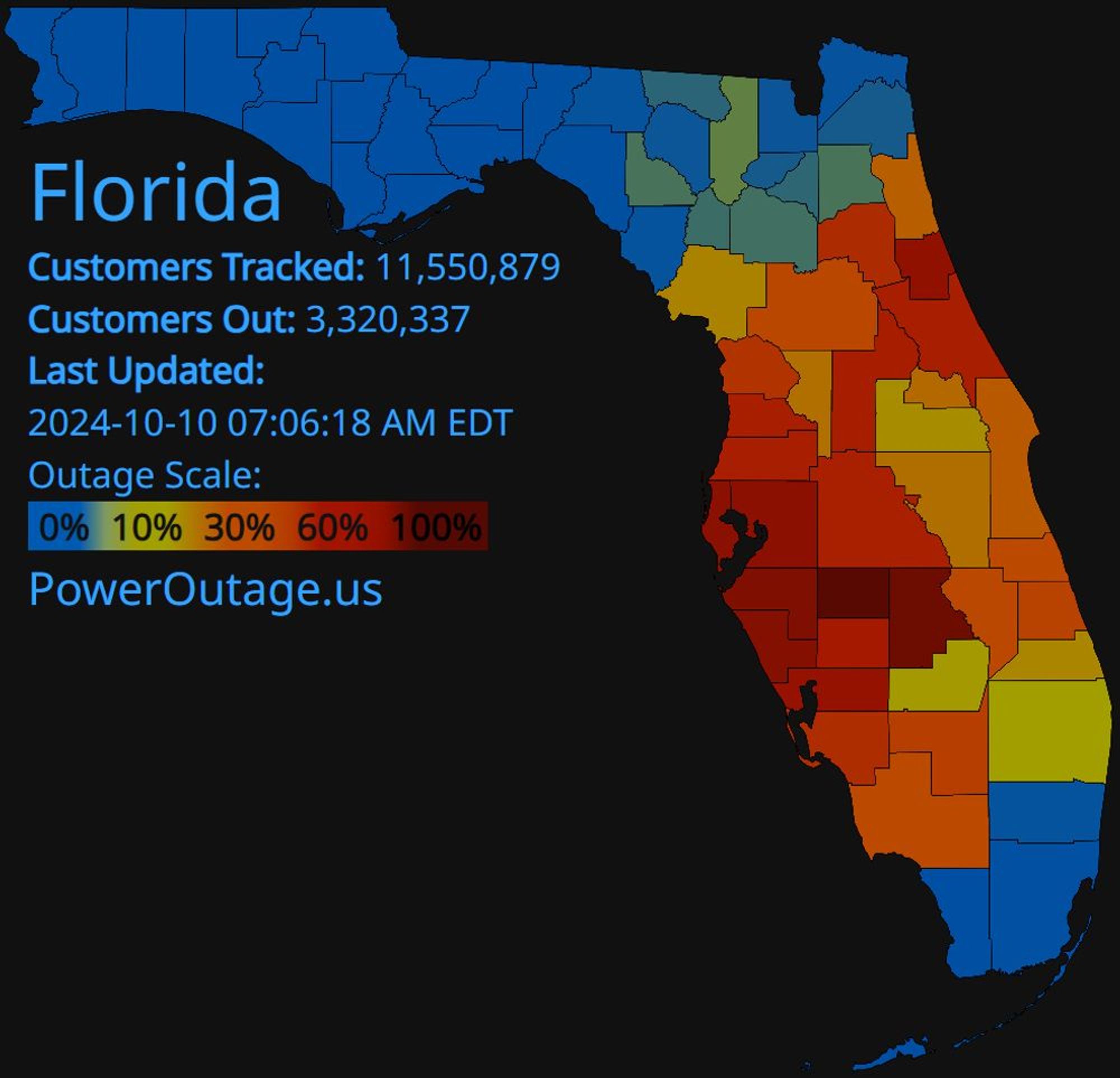
UPDATE 7 AM: Over 3.3 million electric customers are without power in Florida due to #Milton@poweroutage.us 87% of Highlands (Sebring), 78% of Manatee, 75% of Sarasota, 73% of Pinellas, 72% of Hillsborough, 67% of Charlotte, 54% of Volusia, 54% of Lake (Clermont), 53% of Polk (Lakeland)

PowerOutage.us Florida 7:06 AM
1
AFtpa.nws-bot.us

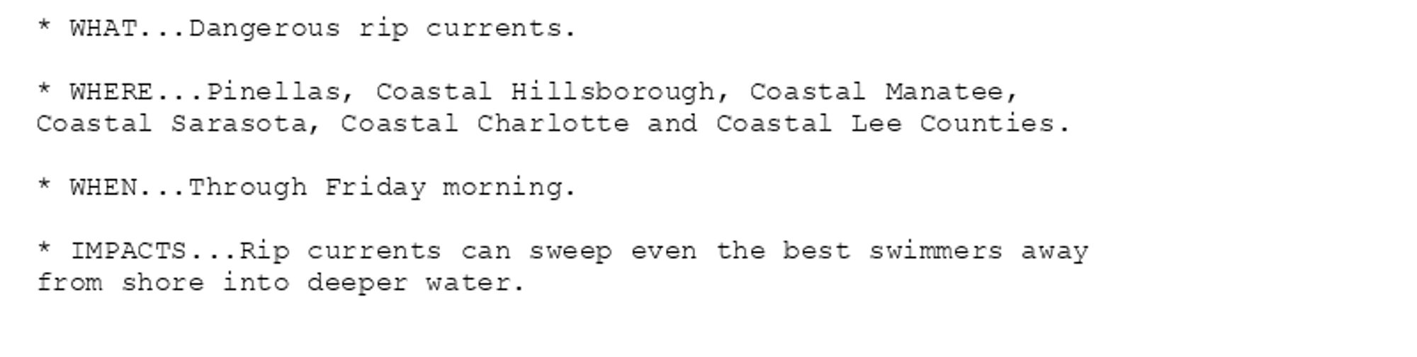
Rip Current Statement issued October 10 at 5:45AM EDT until October 11 at 8:00AM EDT by NWS Tampa Bay Ruskin FL Additional Details Here.

* WHAT...Dangerous rip currents.

* WHERE...Pinellas, Coastal Hillsborough, Coastal Manatee,
Coastal Sarasota, Coastal Charlotte and Coastal Lee Counties.

* WHEN...Through Friday morning.

* IMPACTS...Rip currents can sweep even the best swimmers away
from shore into deeper water.
0

actual hurricane force winds missed pinellas almost entirely this storm was a very stern warning compared to what it could have been #milton#FLwx

the wind history from the nhc for hurricane milton

he was a mean motherfucker but the hurricane force winds were almost entirely between both the major metros of the west coast of florida, on the tampa bay and the gasparilla sound (where ian made landfall) 

the VERY tip of pinellas was in major hurricane force winds but basically nothing else on the north side of the bay

it did continue across the whole peninsula and out into the atlantic at hurricane (but not major hurricane) strength though 

it's a bad one that could have been unimaginably worse
0
AFtpa.nws-bot.us

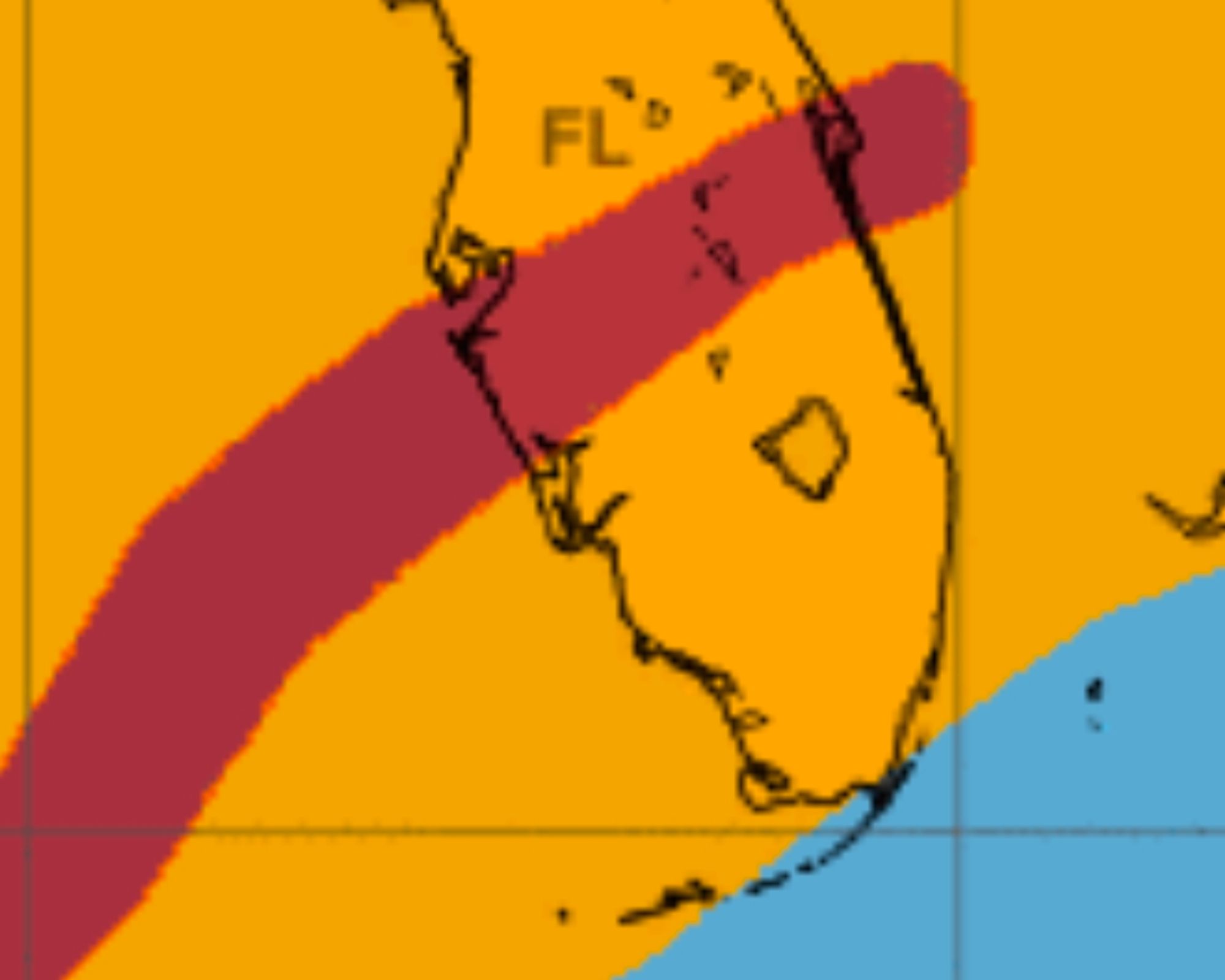
Tropical Cyclone Statement issued October 10 at 5:15AM EDT by NWS Tampa Bay Ruskin FL Additional Details Here.

HLSTBW

This product covers West Central and Southwest Florida

**LINGERING HAZARDOUS CONDITIONS TO IMPROVE LATER TODAY AS MILTON MOVES
AWAY FROM THE AREA**

NEW INFORMATION
---------------

* CHANGES TO WATCHES AND WARNINGS:
- The Storm Surge Warning and Hurricane Warning have been
cancelled for Coastal Hillsborough, Coastal Manatee, Coastal
Pasco, and Pinellas
- The Hurricane Warning has been cancelled for Coastal Charlotte,
Coastal Citrus, Coastal Hernando, Coastal Lee, Coastal Levy,
Coastal Sarasota, DeSoto, Hardee, Inland Charlotte, Inland
Citrus, Inland Hernando, Inland Hillsborough, Inland Lee,
Inland Levy, Inland Manatee, Inland Pasco, and Inland Sarasota

* CURRENT WATCHES AND WARNINGS:
- A Storm Surge Warning is in effect for Coastal Charlotte,
Coastal Lee, Coastal Sarasota, and Inland Lee
- A Hurricane Warning is in effect for Highlands, Polk, and Sumter

* STORM INFORMATION:
- About 150 miles east-northeast of Mouth of Tampa Bay FL
- 28.5N 80.5W
- Storm Intensity 85 mph
- Movement Northeast or 55 degrees at 18 mph

SITUATION OVERVIEW
------------------

Milton remains a minimal hurricane early this morning while moving
across the eastern Florida peninsula. Lingering but diminishing threat
from flash flooding and wind impacts will continue through this
morning mainly over our interior counties before improving as Milton
continues moving away from the peninsula and into the western Atlantic.

POTENTIAL IMPACTS
-----------------

* FLOODING RAIN:
Potential impacts from the flooding rain continue across parts of the
Nature Coast and West-Central Florida. Remain well guarded against
life-threatening flood waters having devastating impacts. If realized,
these impacts include:
- Extreme rainfall flooding may prompt numerous evacuations and
rescues.
- Rivers and tributaries may overwhelmingly overflow their banks
in many places with deep moving water. Small streams, creeks,
canals, and ditches may become raging rivers. Flood control
systems and barriers may become stressed.
- Flood waters can enter numerous structures within multiple
communities, some structures becoming uninhabitable or washed
away. Numerous places where flood waters may cover escape
routes. Streets and parking lots become rivers of raging water
with underpasses submerged. Driving conditions become very
dangerous. Numerous road and bridge closures with some weakened
or washed out.

* WIND:
Potential impacts from the main wind event continue across parts of the
Nature Coast and West-Central Florida. Remain well sheltered from
life-threatening wind having extensive impacts. If realized, these
impacts include:
- Considerable roof damage to sturdy buildings, with some having
window, door, and garage door failures leading to structural
damage. Mobile homes severely damaged, with some destroyed.
Damage accentuated by airborne projectiles. Locations may be
uninhabitable for weeks.
- Many large trees snapped or uprooted along with fences and
roadway signs blown over.
- Some roads impassable from large debris, and more within urban
or heavily wooded places. Several bridges, causeways, and
access routes impassable.
- Large areas with power and communications outages.

* SURGE:
Impacts from the main surge event continue across Southwest Florida.
Remain well away from life-threatening surge. If realized, these
impacts include:
- Areas of inundation with storm surge flooding accentuated by
waves. Damage to several buildings, mainly near the coast.
- Sections of near-shore escape routes and secondary roads become
weakened or washed out, especially in usually vulnerable low
spots.
- Major beach erosion with heavy surf breaching dunes. Strong and
numerous rip currents.
- Moderate damage to marinas, docks, boardwalks, and piers.
Several small craft broken away from moorings, especially in
unprotected anchorages.

* TORNADOES:
Little to no additional impacts are anticipated at this time across
West Central and Southwest Florida.

PRECAUTIONARY/PREPAREDNESS ACTIONS
----------------------------------

* EVACUATIONS:
Follow the advice of local officials.

* OTHER PREPAREDNESS INFORMATION:
Keep your cell phone charged and in power-saving mode. If you lose
power, use it sparingly and mainly for personal emergencies and check-
ins.

Do not venture outside as any improvement in weather will only be
temporary until the storm moves completely out of the area, so remain
safely sheltered from the storm.

Do not be a thrill seeker or risk your life for senseless photos or
videos.

If you are prone to flooding or in an area under a storm surge watch
or warning, be prepared for the possibility of a quick and dramatic
rise in water levels.

* ADDITIONAL SOURCES OF INFORMATION:
- For information on appropriate preparations see ready.gov
- For information on creating an emergency plan see getagameplan.org
- For additional disaster preparedness information see redcross.org

NEXT UPDATE
-----------

The next local statement will be issued by the National Weather
Service in Tampa Bay Ruskin FL around 11 AM EDT, or sooner if
conditions warrant.
0