BLUE
Llucaslimaq.bsky.social

pois ja deixe avisado mamãe que sexta vamos bebemorar d+ logo 📍ali e a felicidade dentro de nós será como uma xícara de copão tropical❤️

0
Aalisonborealis.bsky.social

There are uhhhh 3 hurricanes/typhoons/tropical storms in this image.

Surface air pressure map of the northern hemisphere (focused on north america) for 6pm UTC Oct 2 2024

Remnants of typhoon Jebi are labelled in the upper left near kamchatka.

Two new unnamed storms are labelled "new" in the bottom right off the coast of Florida.

A massive low over Hudson Bay is influencing warm fronts across eastern north america.
A high pressure system is blowing into the Cascadian coast (west coast of northern usa) from across the pacific.
0
NHnhc-epac.nws-bot.us

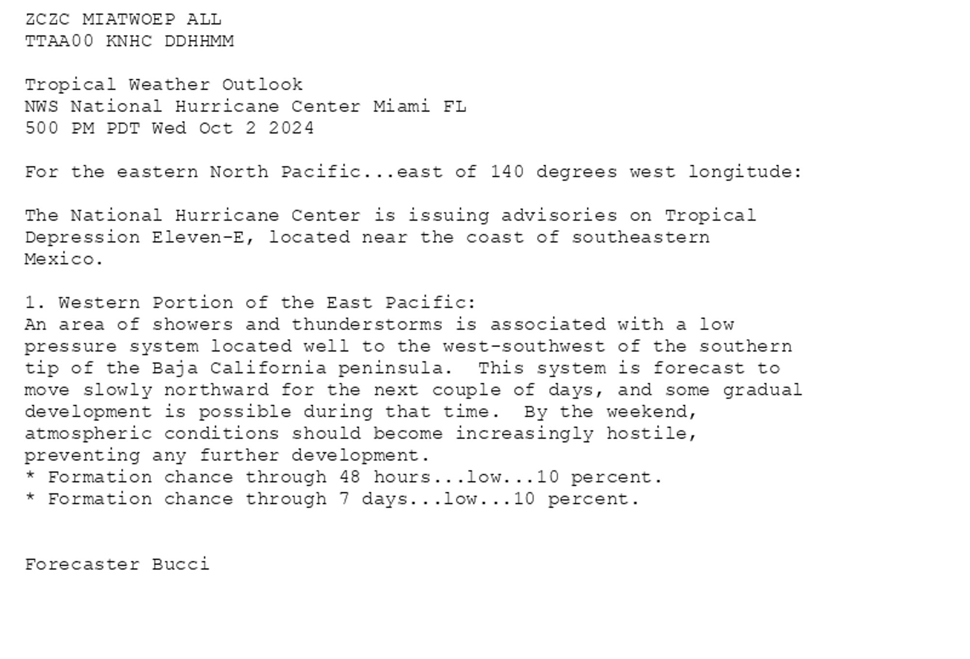
NHC Eastern North Pacific Outlook update for Thu, 03 Oct 2024 00:10:37 GMT Additional Details Here.


ZCZC MIATWOEP ALL<br>TTAA00 KNHC DDHHMM<br><br>Tropical Weather Outlook<br>NWS National Hurricane Center Miami FL<br>500 PM PDT Wed Oct 2 2024<br><br>For the eastern North Pacific...east of 140 degrees west longitude:<br><br>The National Hurricane Center is issuing advisories on Tropical <br>Depression Eleven-E, located near the coast of southeastern <br>Mexico.<br><br>1. Western Portion of the East Pacific:<br>An area of showers and thunderstorms is associated with a low <br>pressure system located well to the west-southwest of the southern <br>tip of the Baja California peninsula.  This system is forecast to  <br>move slowly northward for the next couple of days, and some gradual <br>development is possible during that time.  By the weekend, <br>atmospheric conditions should become increasingly hostile, <br>preventing any further development.<br>* Formation chance through 48 hours...low...10 percent. <br>* Formation chance through 7 days...low...10 percent.<br><br>
<br>Forecaster Bucci<br><br>
Eastern North Pacific 2-Day Graphical Outlook Image
Eastern North Pacific 7-Day Graphical Outlook Image
0
BCbronocosta.bsky.social

Magina que loucura a fervo trazer a liniker pra uma roda de samba ali no pier do tropical, todo mundo na areia só curtindo o sambinha gostoso no por do sol?

0
CAgaryazevedo.bsky.social

Anota a dica aí para o feriadão de nossinhora. Cervejas e drinks para refrescar nesse inferno tropical, dia 12/10 no pingaiada & marineco

0
NHnhc-epac.nws-bot.us

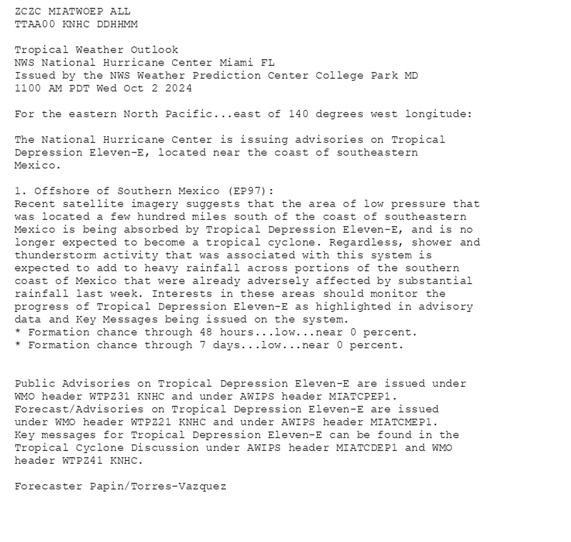
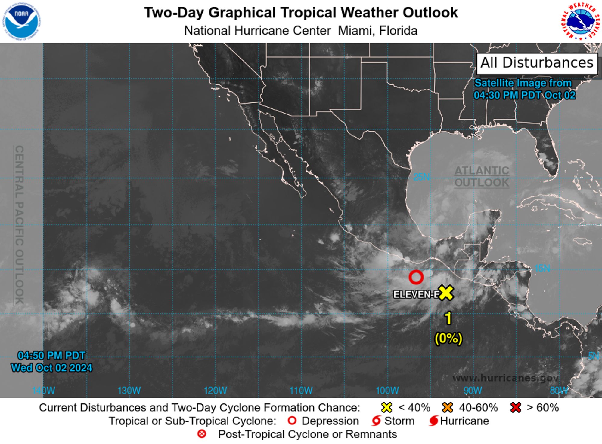
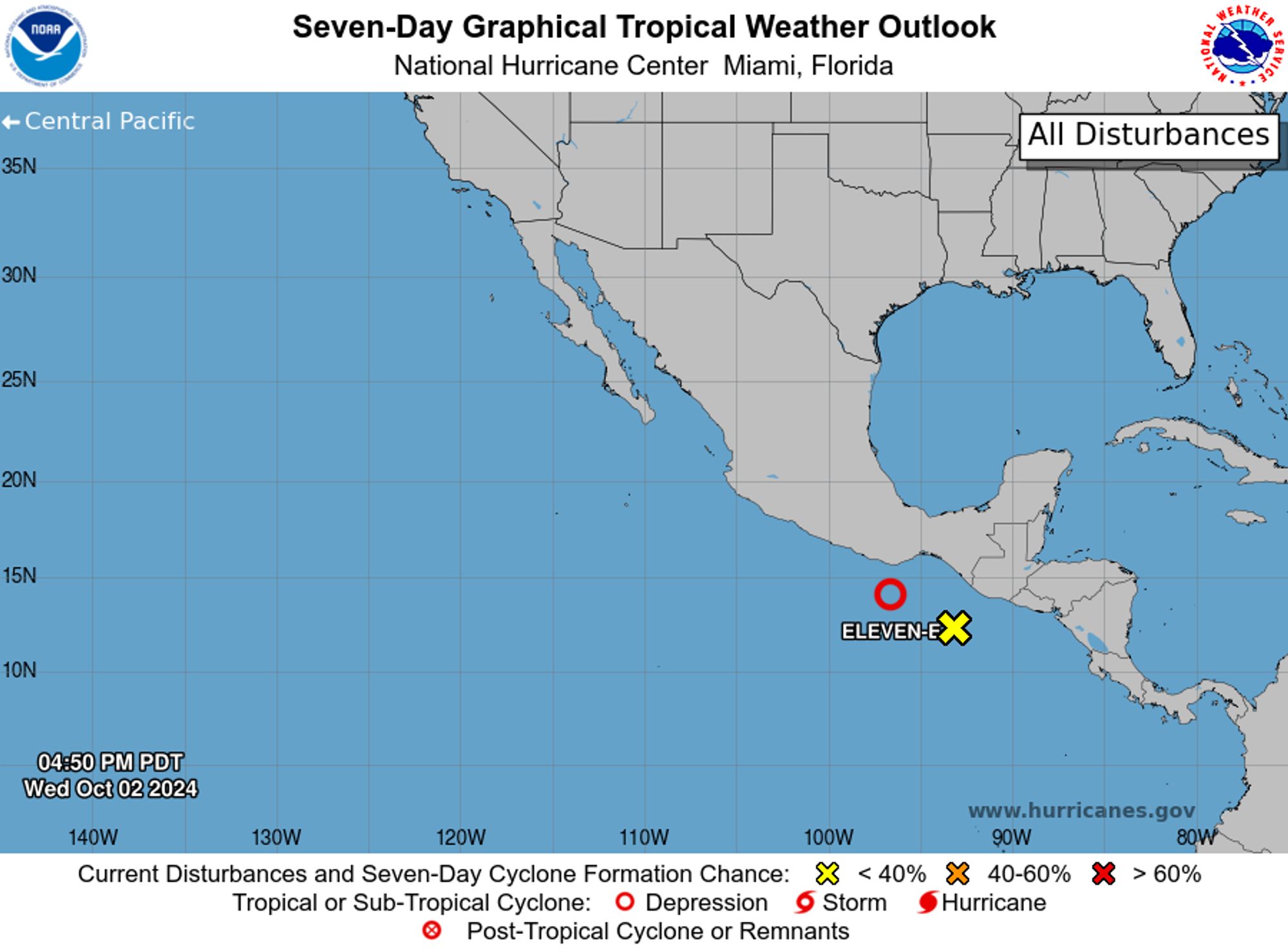
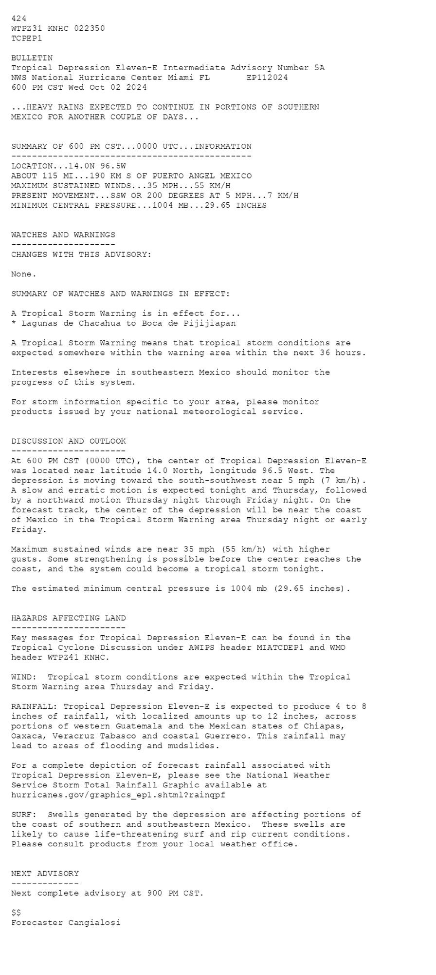
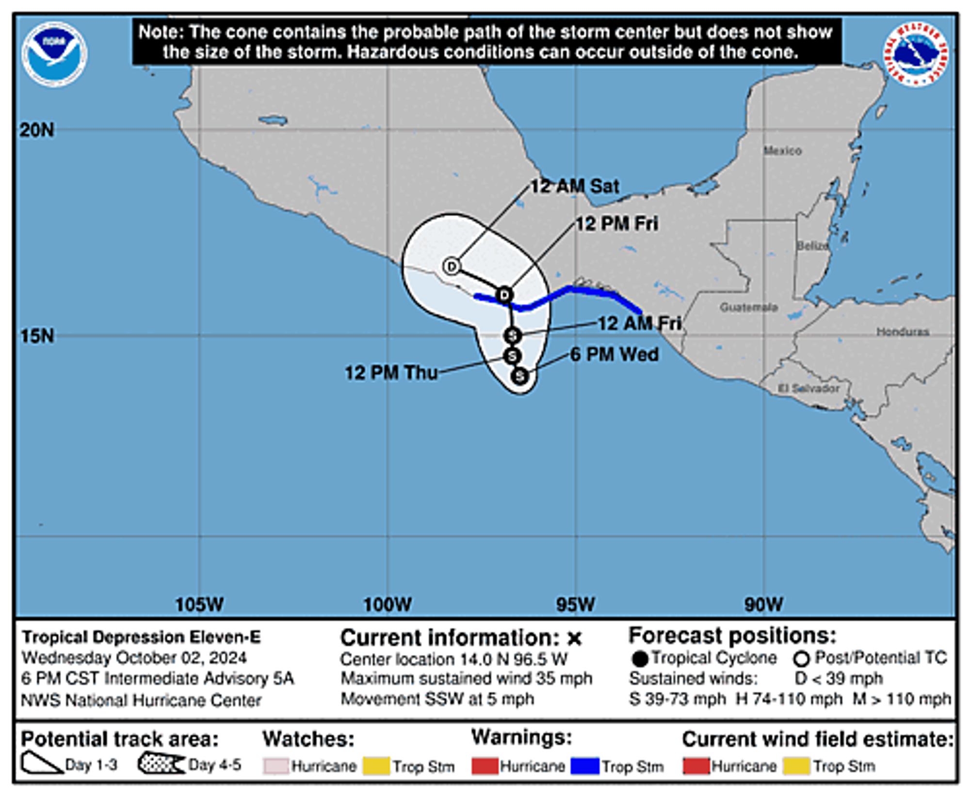
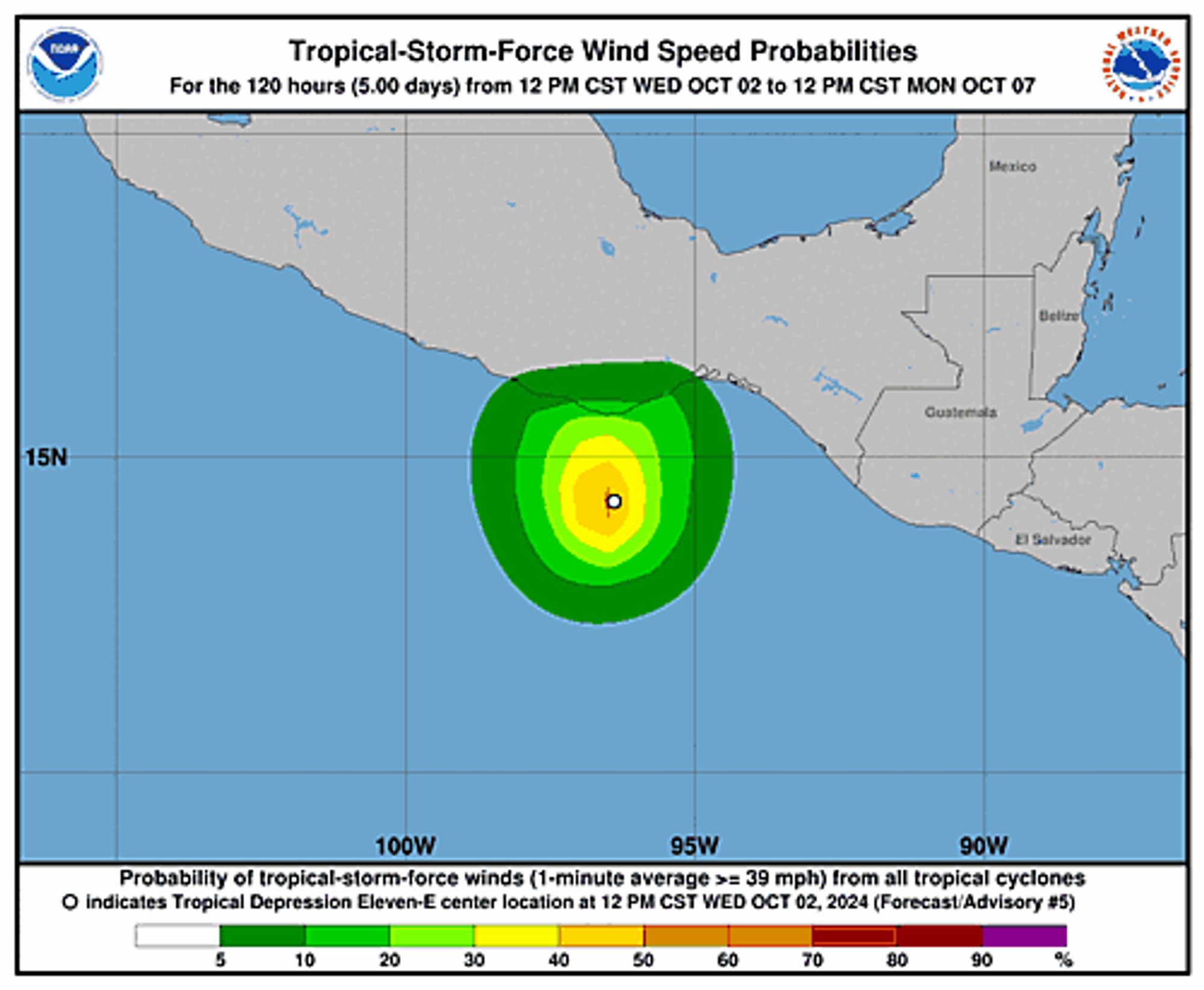
Eastern Pacific Tropical Depression Eleven-E Intermediate Advisory Number 5A issued at Wed, 02 Oct 2024 23:50:08 +0000 ...HEAVY RAINS EXPECTED TO CONTINUE IN PORTIONS OF SOUTHERN MEXICO FOR ANOTHER COUPLE OF DAYS... Additional Details Here.


 <br />
 424 <br />
 WTPZ31 KNHC 022350<br />
 TCPEP1<br />
  <br />
 BULLETIN<br />
 Tropical Depression Eleven-E Intermediate Advisory Number 5A<br />
 NWS National Hurricane Center Miami FL       EP112024<br />
 600 PM CST Wed Oct 02 2024<br />
  <br />
 ...HEAVY RAINS EXPECTED TO CONTINUE IN PORTIONS OF SOUTHERN <br />
 MEXICO FOR ANOTHER COUPLE OF DAYS...<br />
  <br />
  <br />
 SUMMARY OF 600 PM CST...0000 UTC...INFORMATION<br />
 ----------------------------------------------<br />
 LOCATION...14.0N 96.5W<br />
 ABOUT 115 MI...190 KM S OF PUERTO ANGEL MEXICO<br />
 MAXIMUM SUSTAINED WINDS...35 MPH...55 KM/H<br />
 PRESENT MOVEMENT...SSW OR 200 DEGREES AT 5 MPH...7 KM/H<br />
 MINIMUM CENTRAL PRESSURE...1004 MB...29.65 INCHES<br />
  <br />
  <br />
 WATCHES AND WARNINGS<br />
 --------------------<br />
 CHANGES WITH THIS ADVISORY:<br />
  <br />
 None.<br />
  <br />
 SUMMARY OF WATCHES AND WARNINGS IN EFFECT:<br />
  <br />
 A Tropical Storm Warning is in effect for...<br />
 * Lagunas de Chacahua to Boca de Pijijiapan<br />
  <br />
 A Tropical Storm Warning means that tropical storm conditions are<br />
 expected somewhere within the warning area within the next 36 hours.<br />
  <br />
 Interests elsewhere in southeastern Mexico should monitor the<br />
 progress of this system.<br />
  <br />
 For storm information specific to your area, please monitor<br />
 products issued by your national meteorological service.<br />
  <br />
  <br />
 DISCUSSION AND OUTLOOK<br />
 ----------------------<br />
 At 600 PM CST (0000 UTC), the center of Tropical Depression Eleven-E<br />
 was located near latitude 14.0 North, longitude 96.5 West. The<br />
 depression is moving toward the south-southwest near 5 mph (7 km/h).<br />
 A slow and erratic motion is expected tonight and Thursday, followed<br />
 by a northward motion Thursday night through Friday night. On the<br />
 forecast track, the center of the depression will be near the coast<br />
 of Mexico in the Tropical Storm Warning area Thursday night or early<br />
 Friday.<br />
  <br />
 Maximum sustained winds are near 35 mph (55 km/h) with higher<br />
 gusts. Some strengthening is possible before the center reaches the<br />
 coast, and the system could become a tropical storm tonight.<br />
  <br />
 The estimated minimum central pressure is 1004 mb (29.65 inches).<br />
  <br />
  <br />
 HAZARDS AFFECTING LAND<br />
 ----------------------<br />
 Key messages for Tropical Depression Eleven-E can be found in the<br />
 Tropical Cyclone Discussion under AWIPS header MIATCDEP1 and WMO<br />
 header WTPZ41 KNHC.<br />
  <br />
 WIND:  Tropical storm conditions are expected within the Tropical<br />
 Storm Warning area Thursday and Friday.<br />
  <br />
 RAINFALL: Tropical Depression Eleven-E is expected to produce 4 to 8<br />
 inches of rainfall, with localized amounts up to 12 inches, across<br />
 portions of western Guatemala and the Mexican states of Chiapas,<br />
 Oaxaca, Veracruz Tabasco and coastal Guerrero. This rainfall may<br />
 lead to areas of flooding and mudslides.<br />
  <br />
 For a complete depiction of forecast rainfall associated with<br />
 Tropical Depression Eleven-E, please see the National Weather<br />
 Service Storm Total Rainfall Graphic available at<br />
 hurricanes.gov/graphics_ep1.shtml?rainqpf<br />
  <br />
 SURF:  Swells generated by the depression are affecting portions of<br />
 the coast of southern and southeastern Mexico.  These swells are<br />
 likely to cause life-threatening surf and rip current conditions.<br />
 Please consult products from your local weather office.<br />
  <br />
  <br />
 NEXT ADVISORY<br />
 -------------<br />
 Next complete advisory at 900 PM CST.<br />
  <br />
 $$<br />
 Forecaster Cangialosi<br />
  <br />
 <br />
Tropical Depression Eleven-E 5-Day Uncertainty Track Image
Tropical Depression Eleven-E 34-Knot Wind Speed Probabilities
0
NHnhc-cpac.nws-bot.us

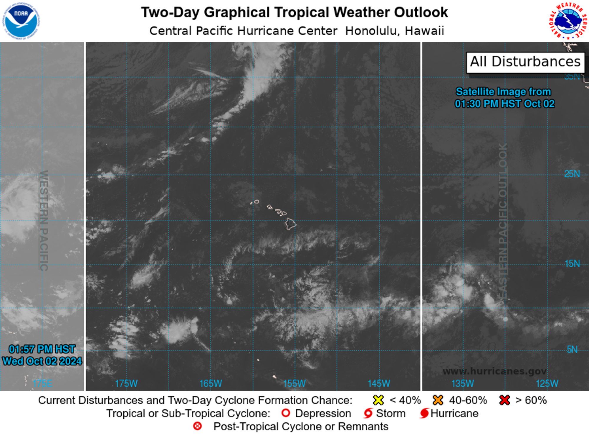
CPHC Central North Pacific Outlook update for Wed, 02 Oct 2024 21:43:18 GMT Additional Details Here.


ZCZC HFOTWOCP ALL<br>TTAA00 PHFO DDHHMM<br><br>Tropical Weather Outlook<br>NWS Central Pacific Hurricane Center Honolulu HI<br>800 AM HST Wed Oct 2 2024<br><br>For the central North Pacific...between 140W and 180W:<br><br>No tropical cyclones are expected during the next 7 days.<br><br>$$<br>Forecaster Kino<br>NNNN<br><br><br>
Central North Pacific 2-Day Graphical Outlook Image
Central North Pacific 7-Day Graphical Outlook Image
0
NHnhc-epac.nws-bot.us

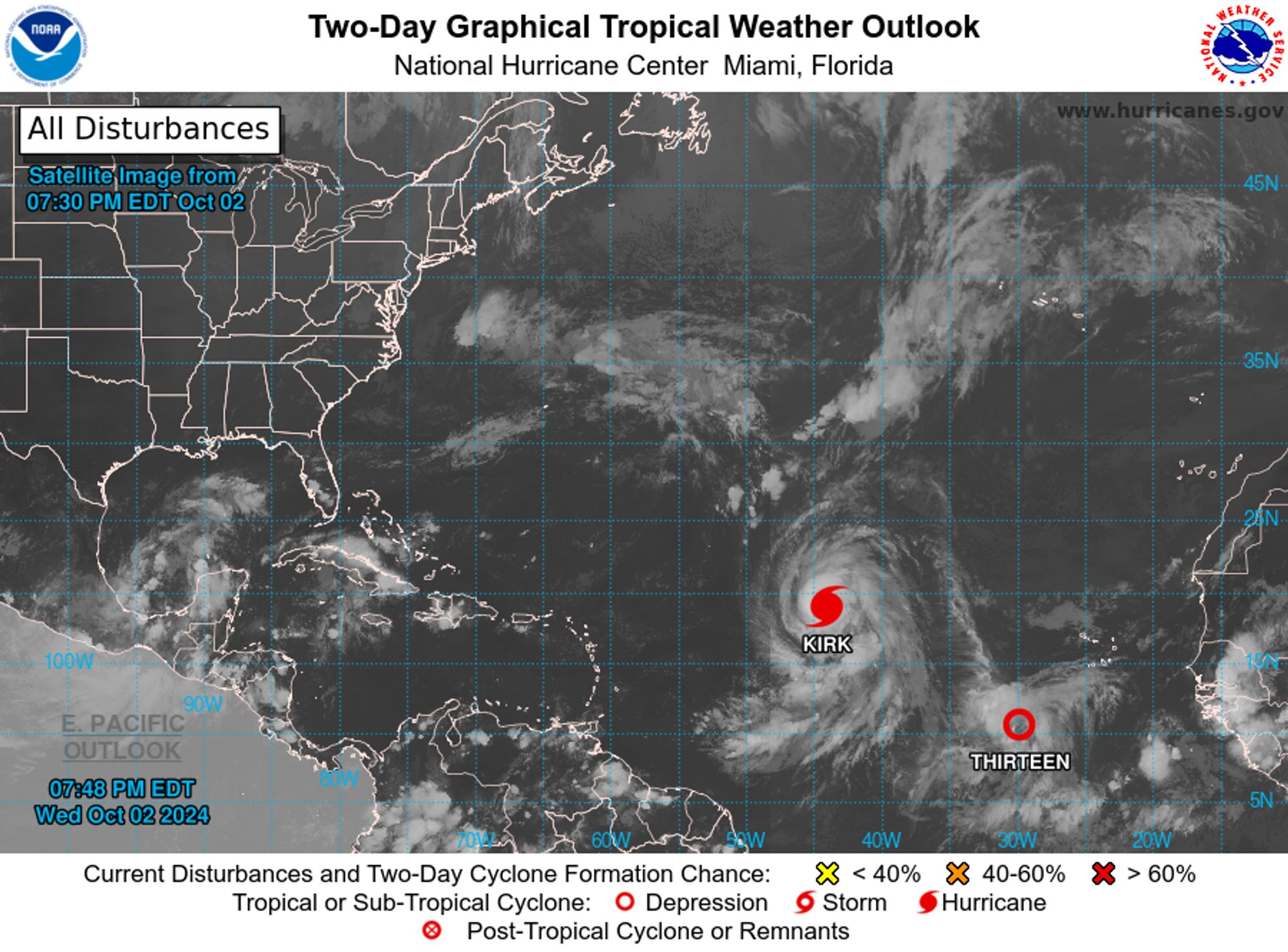
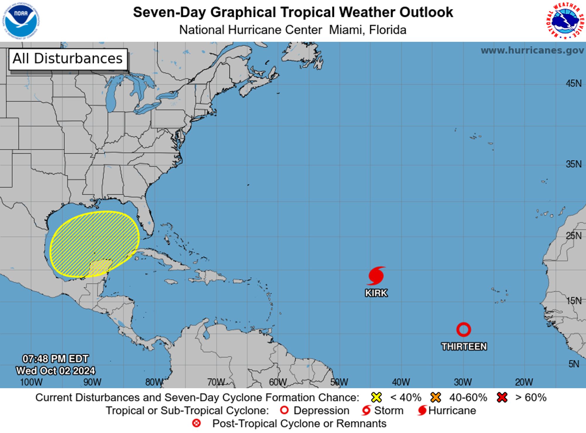
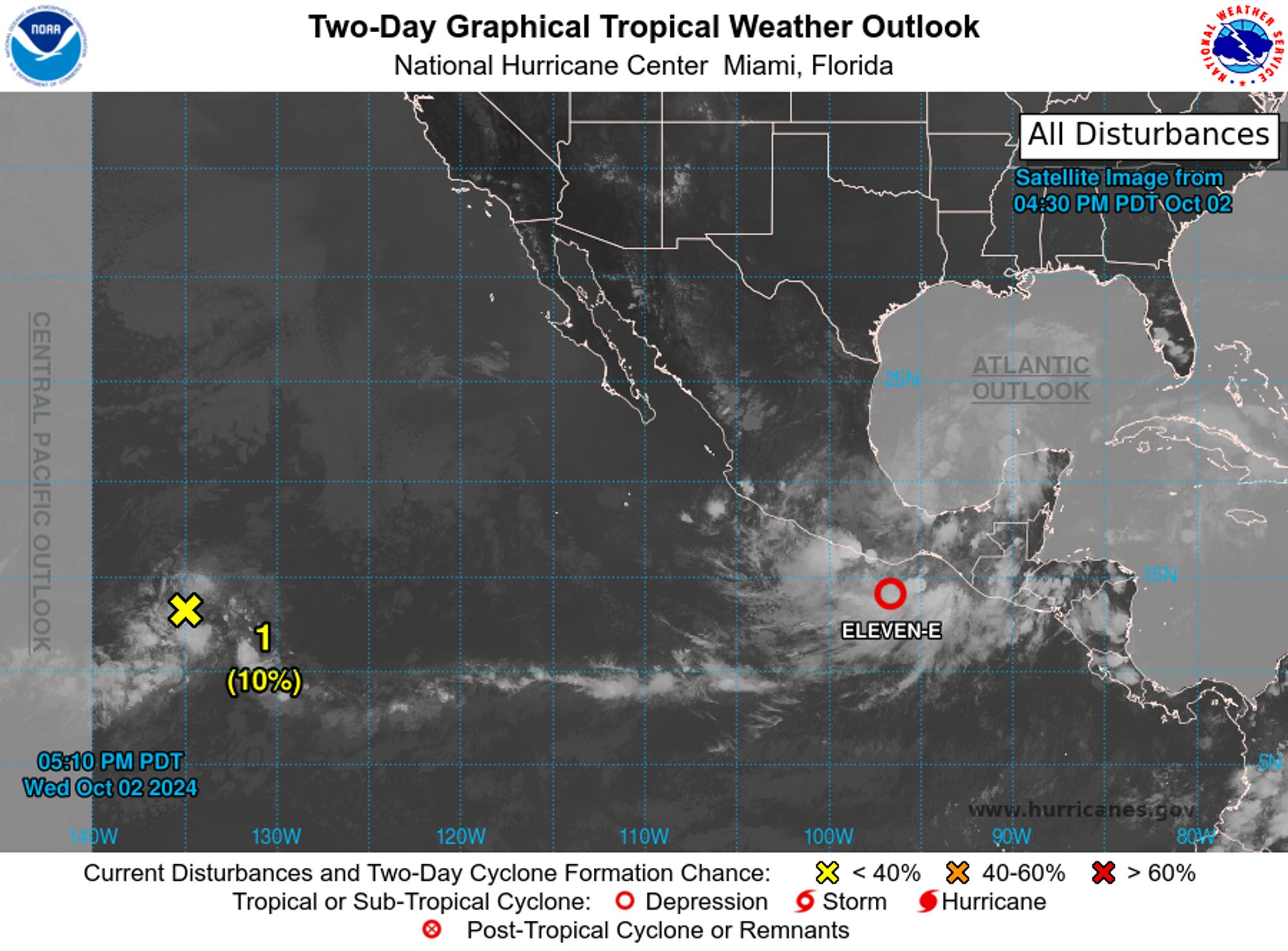
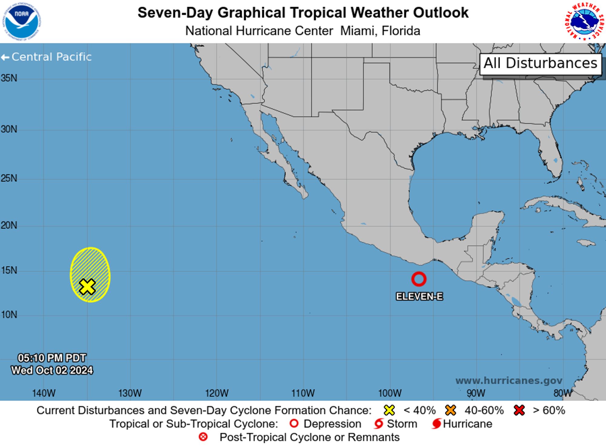
NHC Eastern North Pacific Outlook update for Wed, 02 Oct 2024 23:50:15 GMT Additional Details Here.


ZCZC MIATWOEP ALL<br>TTAA00 KNHC DDHHMM<br><br>Tropical Weather Outlook<br>NWS National Hurricane Center Miami FL<br>Issued by the NWS Weather Prediction Center College Park MD<br>1100 AM PDT Wed Oct 2 2024<br><br>For the eastern North Pacific...east of 140 degrees west longitude:<br><br>The National Hurricane Center is issuing advisories on Tropical <br>Depression Eleven-E, located near the coast of southeastern <br>Mexico.<br><br>1. Offshore of Southern Mexico (EP97):<br>Recent satellite imagery suggests that the area of low pressure that <br>was located a few hundred miles south of the coast of southeastern <br>Mexico is being absorbed by Tropical Depression Eleven-E, and is no <br>longer expected to become a tropical cyclone. Regardless, shower and <br>thunderstorm activity that was associated with this system is <br>expected to add to heavy rainfall across portions of the southern <br>coast of Mexico that were already adversely affected by substantial <br>rainfall last week. Interests in these areas should monitor the <br>progress of Tropical Depression Eleven-E as highlighted in advisory <br>data and Key Messages being issued on the system.<br>* Formation chance through 48 hours...low...near 0 percent. <br>* Formation chance through 7 days...low...near 0 percent.<br><br>
<br>Public Advisories on Tropical Depression Eleven-E are issued under <br>WMO header WTPZ31 KNHC and under AWIPS header MIATCPEP1. <br>Forecast/Advisories on Tropical Depression Eleven-E are issued <br>under WMO header WTPZ21 KNHC and under AWIPS header MIATCMEP1.<br>Key messages for Tropical Depression Eleven-E can be found in the<br>Tropical Cyclone Discussion under AWIPS header MIATCDEP1 and WMO<br>header WTPZ41 KNHC.<br><br>Forecaster Papin/Torres-Vazquez<br><br>
Eastern North Pacific 2-Day Graphical Outlook Image
Eastern North Pacific 7-Day Graphical Outlook Image
0
NHnhc-atlc.nws-bot.us

NHC Atlantic Outlook update for Wed, 02 Oct 2024 23:49:09 GMT Additional Details Here.


ZCZC MIATWOAT ALL<br>TTAA00 KNHC DDHHMM<br><br>Tropical Weather Outlook<br>NWS National Hurricane Center Miami FL<br>800 PM EDT Wed Oct 2 2024<br><br>For the North Atlantic...Caribbean Sea and the Gulf of Mexico:<br><br>Active Systems:<br>The National Hurricane Center is issuing advisories on Hurricane <br>Kirk, located over the central tropical Atlantic Ocean, and on <br>Tropical Depression Thirteen, located over the eastern tropical <br>Atlantic Ocean.<br><br>1. Northwestern Caribbean Sea and Gulf of Mexico:<br>Disorganized showers and thunderstorms over portions of the <br>northwestern Caribbean Sea and the Gulf of Mexico are associated <br>with a trough of low pressure. Environmental conditions could <br>support some gradual development of this system over the Gulf of <br>Mexico this weekend while the system drifts eastward.  Regardless of <br>development, locally heavy rains could occur over portions of Mexico <br>during the next few days and over portions of the Florida Peninsula <br>by the weekend.<br>* Formation chance through 48 hours...low...near 0 percent. <br>* Formation chance through 7 days...low...30 percent.<br><br>
<br>Public Advisories on Tropical Depression Thirteen are issued under <br>WMO header WTNT33 KNHC and under AWIPS header MIATCPAT3.<br>Forecast/Advisories on Tropical Depression Thirteen are issued under <br>WMO header WTNT23 KNHC and under AWIPS header MIATCMAT3.<br><br>Forecaster Cangialosi<br><br>
Atlantic 2-Day Graphical Outlook Image
Atlantic 7-Day Graphical Outlook Image
0