BLUE
AFsju.nws-bot.us

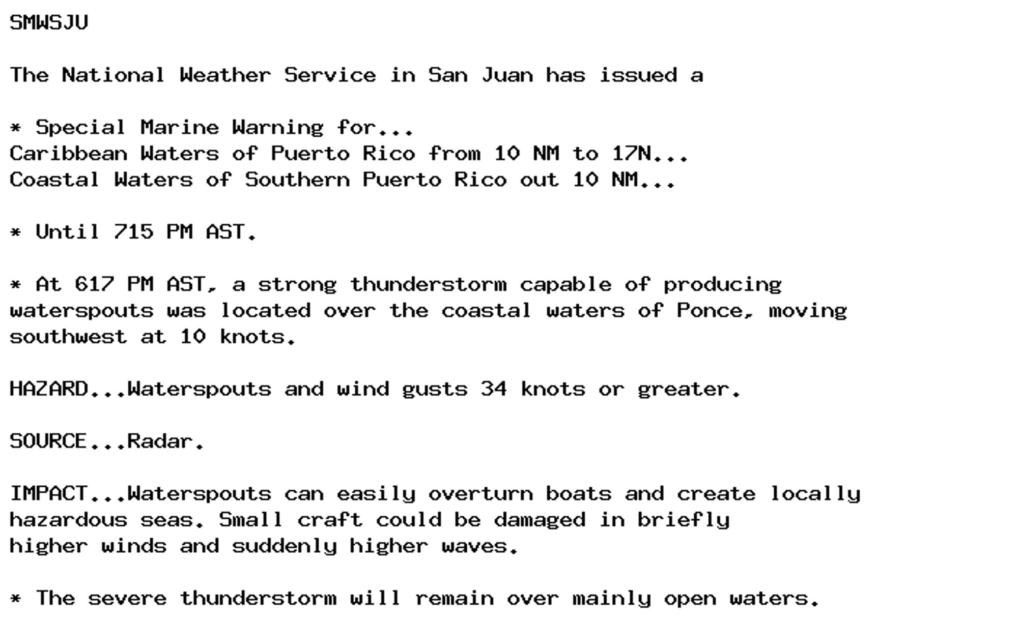
🚨 Special Marine Warning issued October 3 at 6:18PM AST until October 3 at 7:15PM AST by NWS San Juan PR 🚨 Additional Details Here.

SMWSJU

The National Weather Service in San Juan has issued a

* Special Marine Warning for...
Caribbean Waters of Puerto Rico from 10 NM to 17N...
Coastal Waters of Southern Puerto Rico out 10 NM...

* Until 715 PM AST.

* At 617 PM AST, a strong thunderstorm capable of producing
waterspouts was located over the coastal waters of Ponce, moving
southwest at 10 knots.

HAZARD...Waterspouts and wind gusts 34 knots or greater.

SOURCE...Radar.

IMPACT...Waterspouts can easily overturn boats and create locally
hazardous seas. Small craft could be damaged in briefly
higher winds and suddenly higher waves.

* The severe thunderstorm will remain over mainly open waters.
0
AFtlh.nws-bot.us

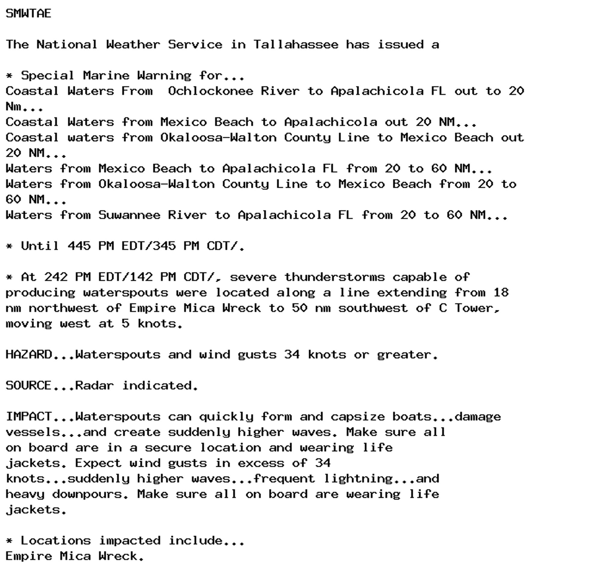
🚨 Special Marine Warning issued October 3 at 2:42PM EDT until October 3 at 4:45PM EDT by NWS Tallahassee FL 🚨 Additional Details Here.

SMWTAE

The National Weather Service in Tallahassee has issued a

* Special Marine Warning for...
Coastal Waters From  Ochlockonee River to Apalachicola FL out to 20
Nm...
Coastal Waters from Mexico Beach to Apalachicola out 20 NM...
Coastal waters from Okaloosa-Walton County Line to Mexico Beach out
20 NM...
Waters from Mexico Beach to Apalachicola FL from 20 to 60 NM...
Waters from Okaloosa-Walton County Line to Mexico Beach from 20 to
60 NM...
Waters from Suwannee River to Apalachicola FL from 20 to 60 NM...

* Until 445 PM EDT/345 PM CDT/.

* At 242 PM EDT/142 PM CDT/, severe thunderstorms capable of
producing waterspouts were located along a line extending from 18
nm northwest of Empire Mica Wreck to 50 nm southwest of C Tower,
moving west at 5 knots.

HAZARD...Waterspouts and wind gusts 34 knots or greater.

SOURCE...Radar indicated.

IMPACT...Waterspouts can quickly form and capsize boats...damage
vessels...and create suddenly higher waves. Make sure all
on board are in a secure location and wearing life
jackets. Expect wind gusts in excess of 34
knots...suddenly higher waves...frequent lightning...and
heavy downpours. Make sure all on board are wearing life
jackets.

* Locations impacted include...
Empire Mica Wreck.
0
AFtlh.nws-bot.us

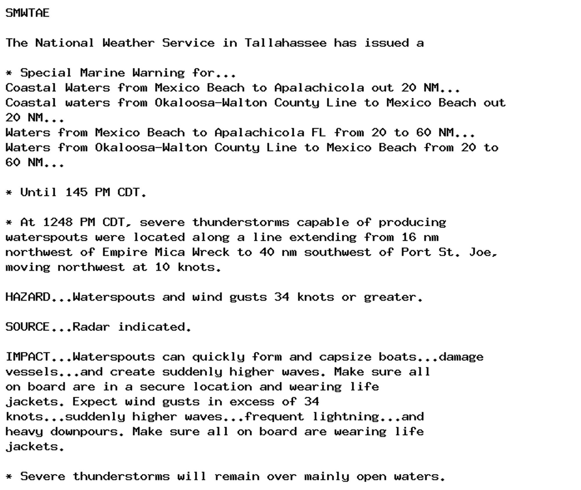
🚨 Special Marine Warning issued October 3 at 12:48PM CDT until October 3 at 1:45PM CDT by NWS Tallahassee FL 🚨 Additional Details Here.

SMWTAE

The National Weather Service in Tallahassee has issued a

* Special Marine Warning for...
Coastal Waters from Mexico Beach to Apalachicola out 20 NM...
Coastal waters from Okaloosa-Walton County Line to Mexico Beach out
20 NM...
Waters from Mexico Beach to Apalachicola FL from 20 to 60 NM...
Waters from Okaloosa-Walton County Line to Mexico Beach from 20 to
60 NM...

* Until 145 PM CDT.

* At 1248 PM CDT, severe thunderstorms capable of producing
waterspouts were located along a line extending from 16 nm
northwest of Empire Mica Wreck to 40 nm southwest of Port St. Joe,
moving northwest at 10 knots.

HAZARD...Waterspouts and wind gusts 34 knots or greater.

SOURCE...Radar indicated.

IMPACT...Waterspouts can quickly form and capsize boats...damage
vessels...and create suddenly higher waves. Make sure all
on board are in a secure location and wearing life
jackets. Expect wind gusts in excess of 34
knots...suddenly higher waves...frequent lightning...and
heavy downpours. Make sure all on board are wearing life
jackets.

* Severe thunderstorms will remain over mainly open waters.
0
AFjax.nws-bot.us

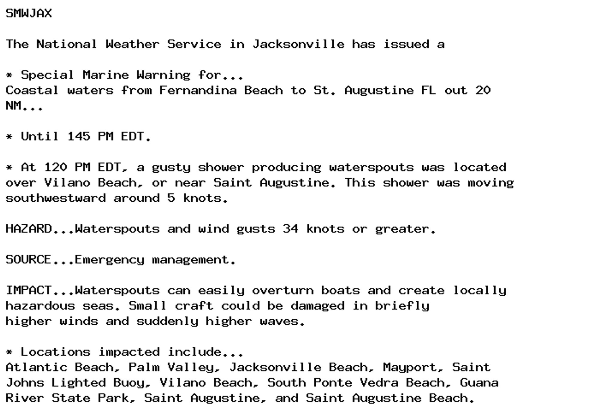
🚨 Special Marine Warning issued October 3 at 1:21PM EDT until October 3 at 1:45PM EDT by NWS Jacksonville FL 🚨 Additional Details Here.

SMWJAX

The National Weather Service in Jacksonville has issued a

* Special Marine Warning for...
Coastal waters from Fernandina Beach to St. Augustine FL out 20
NM...

* Until 145 PM EDT.

* At 120 PM EDT, a gusty shower producing waterspouts was located
over Vilano Beach, or near Saint Augustine. This shower was moving
southwestward around 5 knots.

HAZARD...Waterspouts and wind gusts 34 knots or greater.

SOURCE...Emergency management.

IMPACT...Waterspouts can easily overturn boats and create locally
hazardous seas. Small craft could be damaged in briefly
higher winds and suddenly higher waves.

* Locations impacted include...
Atlantic Beach, Palm Valley, Jacksonville Beach, Mayport, Saint
Johns Lighted Buoy, Vilano Beach, South Ponte Vedra Beach, Guana
River State Park, Saint Augustine, and Saint Augustine Beach.
0
AFtlh.nws-bot.us

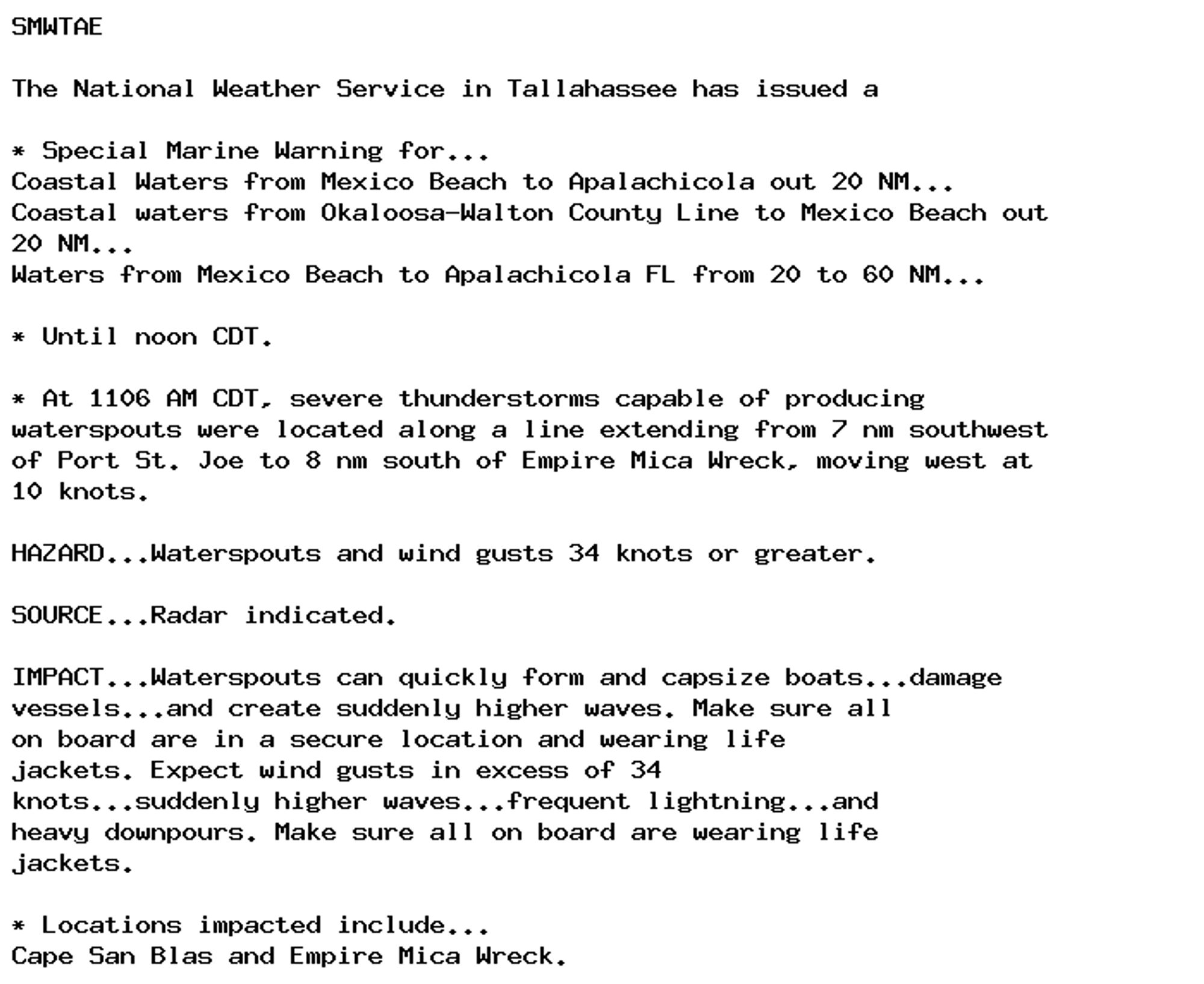
🚨 Special Marine Warning issued October 3 at 11:07AM CDT until October 3 at 12:00PM CDT by NWS Tallahassee FL 🚨 Additional Details Here.

SMWTAE

The National Weather Service in Tallahassee has issued a

* Special Marine Warning for...
Coastal Waters from Mexico Beach to Apalachicola out 20 NM...
Coastal waters from Okaloosa-Walton County Line to Mexico Beach out
20 NM...
Waters from Mexico Beach to Apalachicola FL from 20 to 60 NM...

* Until noon CDT.

* At 1106 AM CDT, severe thunderstorms capable of producing
waterspouts were located along a line extending from 7 nm southwest
of Port St. Joe to 8 nm south of Empire Mica Wreck, moving west at
10 knots.

HAZARD...Waterspouts and wind gusts 34 knots or greater.

SOURCE...Radar indicated.

IMPACT...Waterspouts can quickly form and capsize boats...damage
vessels...and create suddenly higher waves. Make sure all
on board are in a secure location and wearing life
jackets. Expect wind gusts in excess of 34
knots...suddenly higher waves...frequent lightning...and
heavy downpours. Make sure all on board are wearing life
jackets.

* Locations impacted include...
Cape San Blas and Empire Mica Wreck.
0
AFmhx.nws-bot.us

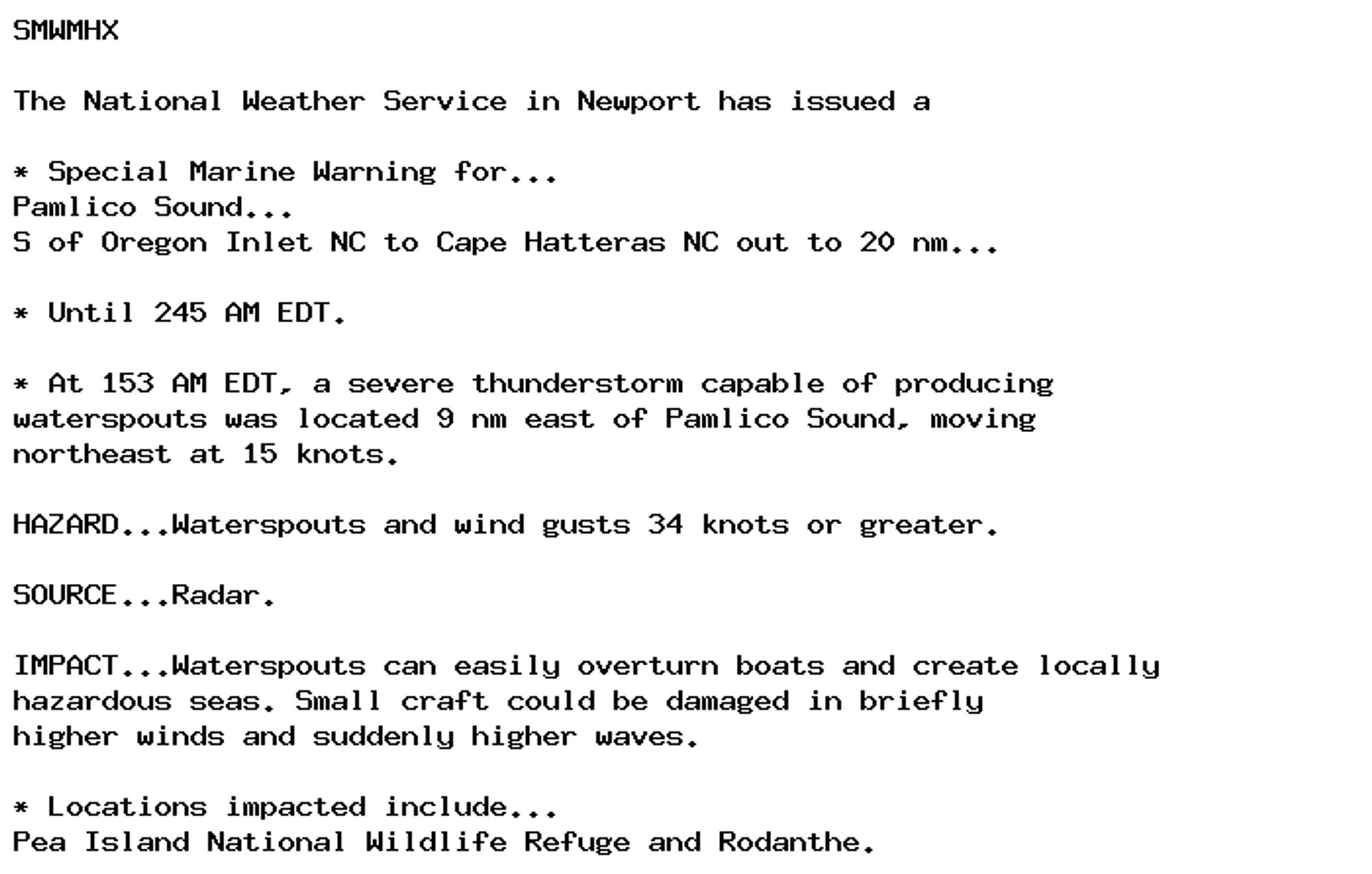
🚨 Special Marine Warning issued October 1 at 1:53AM EDT until October 1 at 2:45AM EDT by NWS Newport/Morehead City NC 🚨 Additional Details Here.

SMWMHX

The National Weather Service in Newport has issued a

* Special Marine Warning for...
Pamlico Sound...
S of Oregon Inlet NC to Cape Hatteras NC out to 20 nm...

* Until 245 AM EDT.

* At 153 AM EDT, a severe thunderstorm capable of producing
waterspouts was located 9 nm east of Pamlico Sound, moving
northeast at 15 knots.

HAZARD...Waterspouts and wind gusts 34 knots or greater.

SOURCE...Radar.

IMPACT...Waterspouts can easily overturn boats and create locally
hazardous seas. Small craft could be damaged in briefly
higher winds and suddenly higher waves.

* Locations impacted include...
Pea Island National Wildlife Refuge and Rodanthe.
0
AFmhx.nws-bot.us

🚨 Special Marine Warning issued October 1 at 12:13AM EDT until October 1 at 12:30AM EDT by NWS Newport/Morehead City NC 🚨 Additional Details Here.

For the following areas...
Pamlico Sound...

At 1212 AM EDT, a severe thunderstorm capable of producing
waterspouts was located near Swanquarter, moving east at 15 knots.

HAZARD...Waterspouts and wind gusts to 40 knots.

SOURCE...Radar indicated.

IMPACT...Waterspouts can easily overturn boats and create locally
hazardous seas. Small craft could be damaged in briefly
higher winds and suddenly higher waves.

The severe thunderstorm will remain over mainly open waters.
0

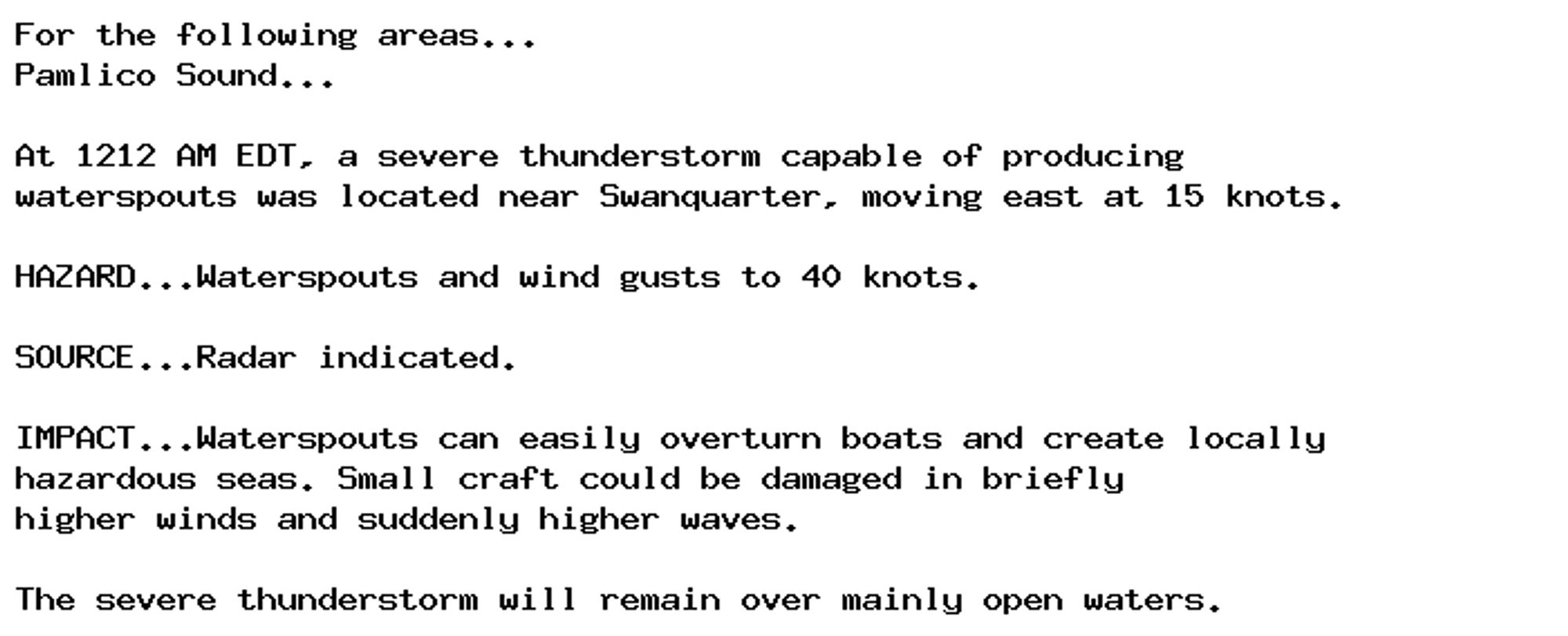
NEW WEATHER ADVISORY: Special Marine Warning For the following areas... Pamlico Sound... At 1212 AM EDT, a severe thunderstorm capable of producing waterspouts was located near Swanquarter, moving east at 15 knots. HAZARD...Waterspouts and wind gusts... See more: watchedsky.social/app/alerts/...

0
AFmhx.nws-bot.us

🚨 Special Marine Warning issued September 30 at 11:57PM EDT until October 1 at 12:30AM EDT by NWS Newport/Morehead City NC 🚨 Additional Details Here.

SMWMHX

The National Weather Service in Newport has issued a

* Special Marine Warning for...
Pamlico Sound...

* Until 1230 AM EDT.

* At 1157 PM EDT, a severe thunderstorm capable of producing
waterspouts was located near The Mouth Of The Pamlico River, moving
east at 15 knots.

HAZARD...Waterspouts and wind gusts to 40 knots.

SOURCE...Radar.

IMPACT...Waterspouts can easily overturn boats and create locally
hazardous seas. Small craft could be damaged in briefly
higher winds and suddenly higher waves.

* Locations impacted include...
Swanquarter.
0

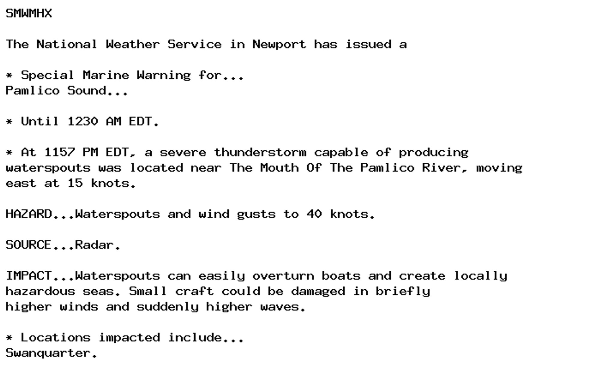
NEW WEATHER ADVISORY: Special Marine Warning SMWMHX The National Weather Service in Newport has issued a * Special Marine Warning for... Pamlico Sound... * Until 1230 AM EDT. * At 1157 PM EDT, a severe thunderstorm capable of producing waterspouts... See more: watchedsky.social/app/alerts/...

2