BLUE
AFcae.nws-bot.us

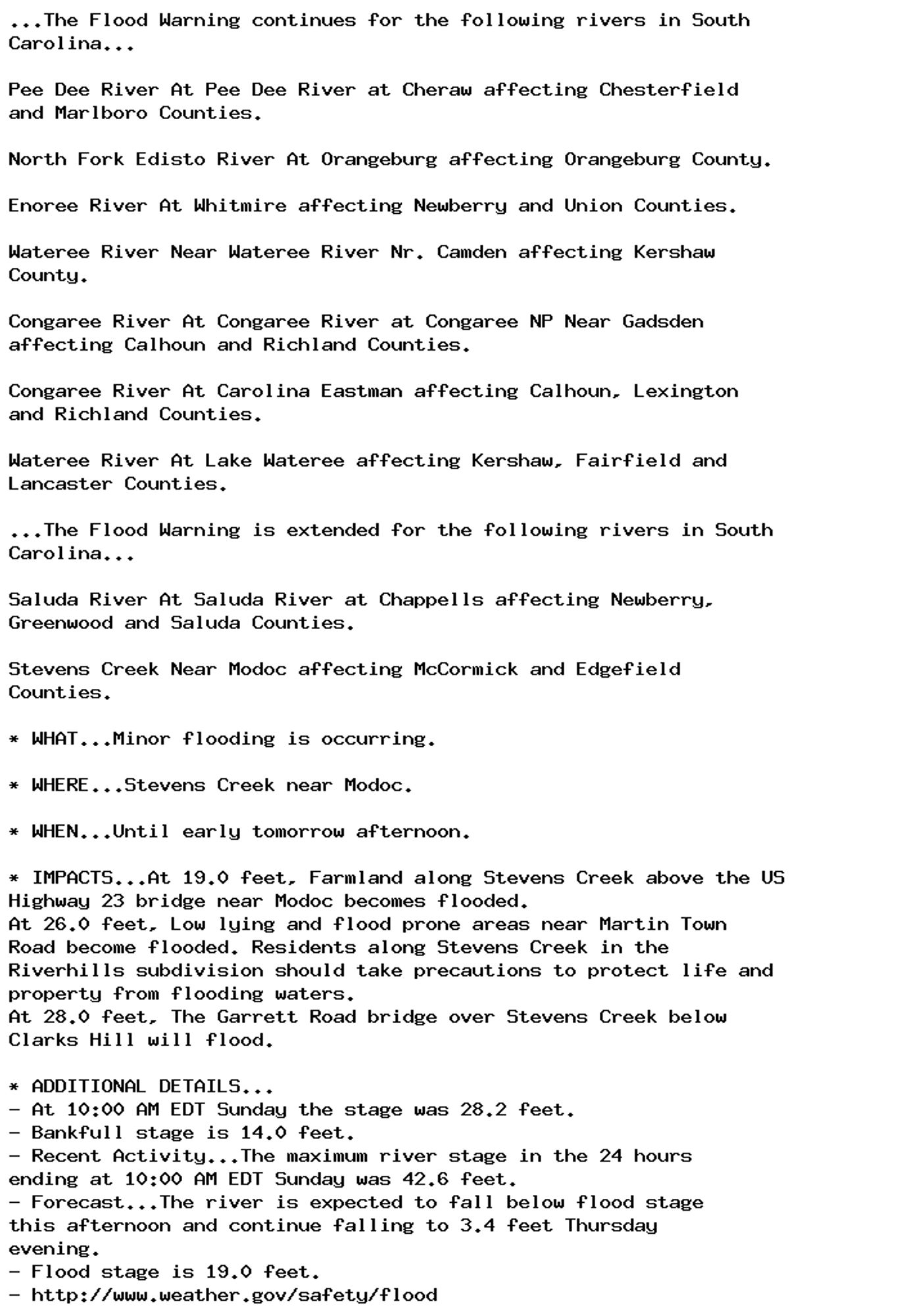
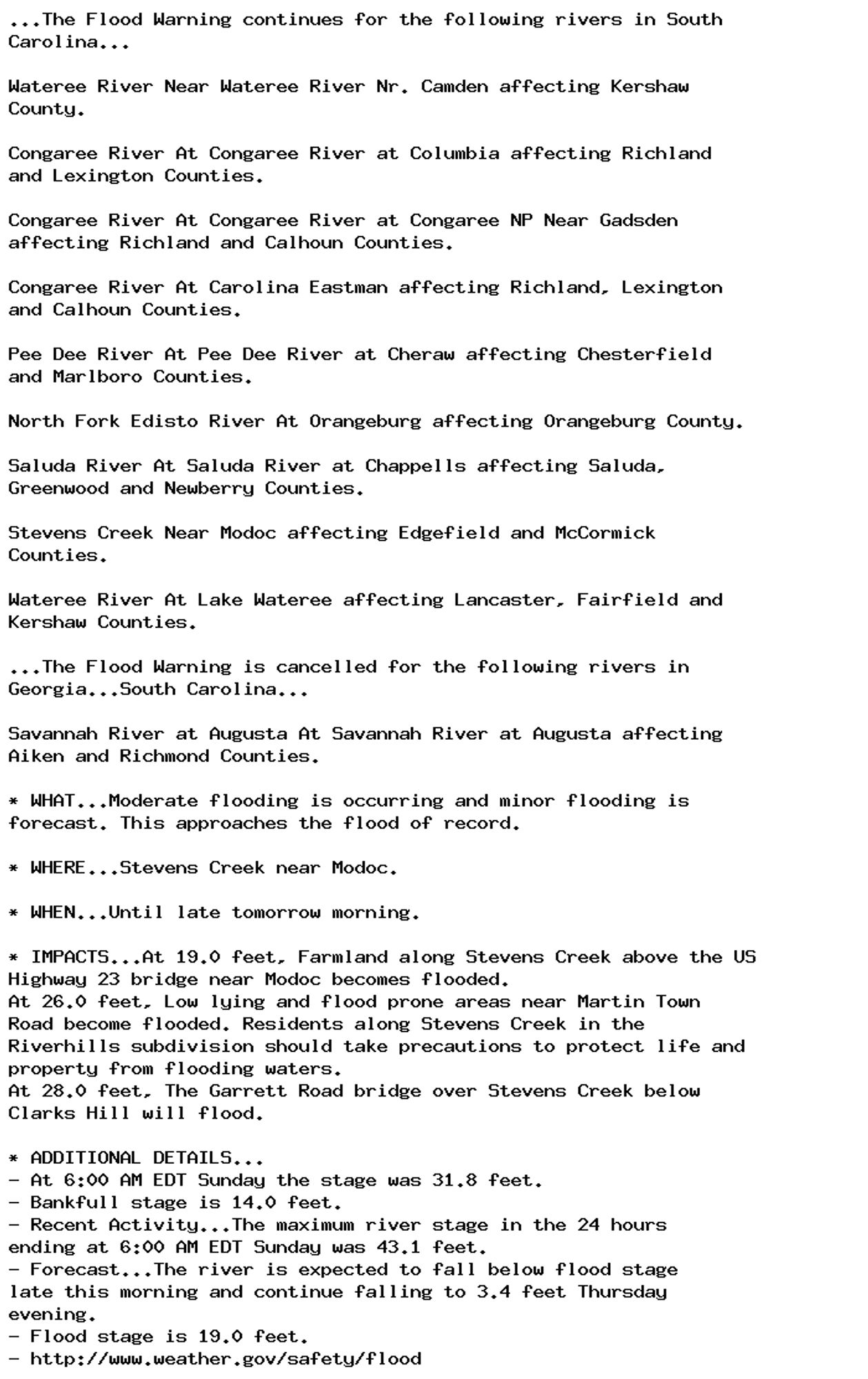
Flood Warning issued September 29 at 11:03AM EDT until September 30 at 12:47PM EDT by NWS Columbia SC Additional Details Here.

...The Flood Warning continues for the following rivers in South
Carolina...

Pee Dee River At Pee Dee River at Cheraw affecting Chesterfield
and Marlboro Counties.

North Fork Edisto River At Orangeburg affecting Orangeburg County.

Enoree River At Whitmire affecting Newberry and Union Counties.

Wateree River Near Wateree River Nr. Camden affecting Kershaw
County.

Congaree River At Congaree River at Congaree NP Near Gadsden
affecting Calhoun and Richland Counties.

Congaree River At Carolina Eastman affecting Calhoun, Lexington
and Richland Counties.

Wateree River At Lake Wateree affecting Kershaw, Fairfield and
Lancaster Counties.

...The Flood Warning is extended for the following rivers in South
Carolina...

Saluda River At Saluda River at Chappells affecting Newberry,
Greenwood and Saluda Counties.

Stevens Creek Near Modoc affecting McCormick and Edgefield
Counties.

* WHAT...Minor flooding is occurring.

* WHERE...Stevens Creek near Modoc.

* WHEN...Until early tomorrow afternoon.

* IMPACTS...At 19.0 feet, Farmland along Stevens Creek above the US
Highway 23 bridge near Modoc becomes flooded.
At 26.0 feet, Low lying and flood prone areas near Martin Town
Road become flooded. Residents along Stevens Creek in the
Riverhills subdivision should take precautions to protect life and
property from flooding waters.
At 28.0 feet, The Garrett Road bridge over Stevens Creek below
Clarks Hill will flood.

* ADDITIONAL DETAILS...
- At 10:00 AM EDT Sunday the stage was 28.2 feet.
- Bankfull stage is 14.0 feet.
- Recent Activity...The maximum river stage in the 24 hours
ending at 10:00 AM EDT Sunday was 42.6 feet.
- Forecast...The river is expected to fall below flood stage
this afternoon and continue falling to 3.4 feet Thursday
evening.
- Flood stage is 19.0 feet.
- http://www.weather.gov/safety/flood
0
Tsveva-1506.bsky.social

Beh, noi guai a non avere il loden e le Clarks …

1
AFcae.nws-bot.us

Flood Warning issued September 29 at 6:51AM EDT until September 30 at 9:51AM EDT by NWS Columbia SC Additional Details Here.

...The Flood Warning continues for the following rivers in South
Carolina...

Wateree River Near Wateree River Nr. Camden affecting Kershaw
County.

Congaree River At Congaree River at Columbia affecting Richland
and Lexington Counties.

Congaree River At Congaree River at Congaree NP Near Gadsden
affecting Richland and Calhoun Counties.

Congaree River At Carolina Eastman affecting Richland, Lexington
and Calhoun Counties.

Pee Dee River At Pee Dee River at Cheraw affecting Chesterfield
and Marlboro Counties.

North Fork Edisto River At Orangeburg affecting Orangeburg County.

Saluda River At Saluda River at Chappells affecting Saluda,
Greenwood and Newberry Counties.

Stevens Creek Near Modoc affecting Edgefield and McCormick
Counties.

Wateree River At Lake Wateree affecting Lancaster, Fairfield and
Kershaw Counties.

...The Flood Warning is cancelled for the following rivers in
Georgia...South Carolina...

Savannah River at Augusta At Savannah River at Augusta affecting
Aiken and Richmond Counties.

* WHAT...Moderate flooding is occurring and minor flooding is
forecast. This approaches the flood of record.

* WHERE...Stevens Creek near Modoc.

* WHEN...Until late tomorrow morning.

* IMPACTS...At 19.0 feet, Farmland along Stevens Creek above the US
Highway 23 bridge near Modoc becomes flooded.
At 26.0 feet, Low lying and flood prone areas near Martin Town
Road become flooded. Residents along Stevens Creek in the
Riverhills subdivision should take precautions to protect life and
property from flooding waters.
At 28.0 feet, The Garrett Road bridge over Stevens Creek below
Clarks Hill will flood.

* ADDITIONAL DETAILS...
- At 6:00 AM EDT Sunday the stage was 31.8 feet.
- Bankfull stage is 14.0 feet.
- Recent Activity...The maximum river stage in the 24 hours
ending at 6:00 AM EDT Sunday was 43.1 feet.
- Forecast...The river is expected to fall below flood stage
late this morning and continue falling to 3.4 feet Thursday
evening.
- Flood stage is 19.0 feet.
- http://www.weather.gov/safety/flood
0
AFrnk.nws-bot.us

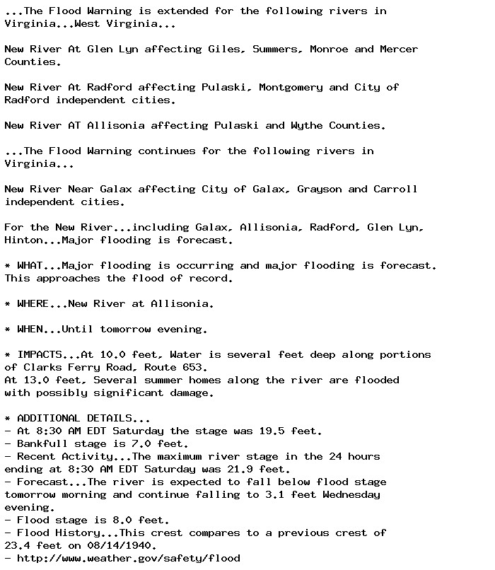
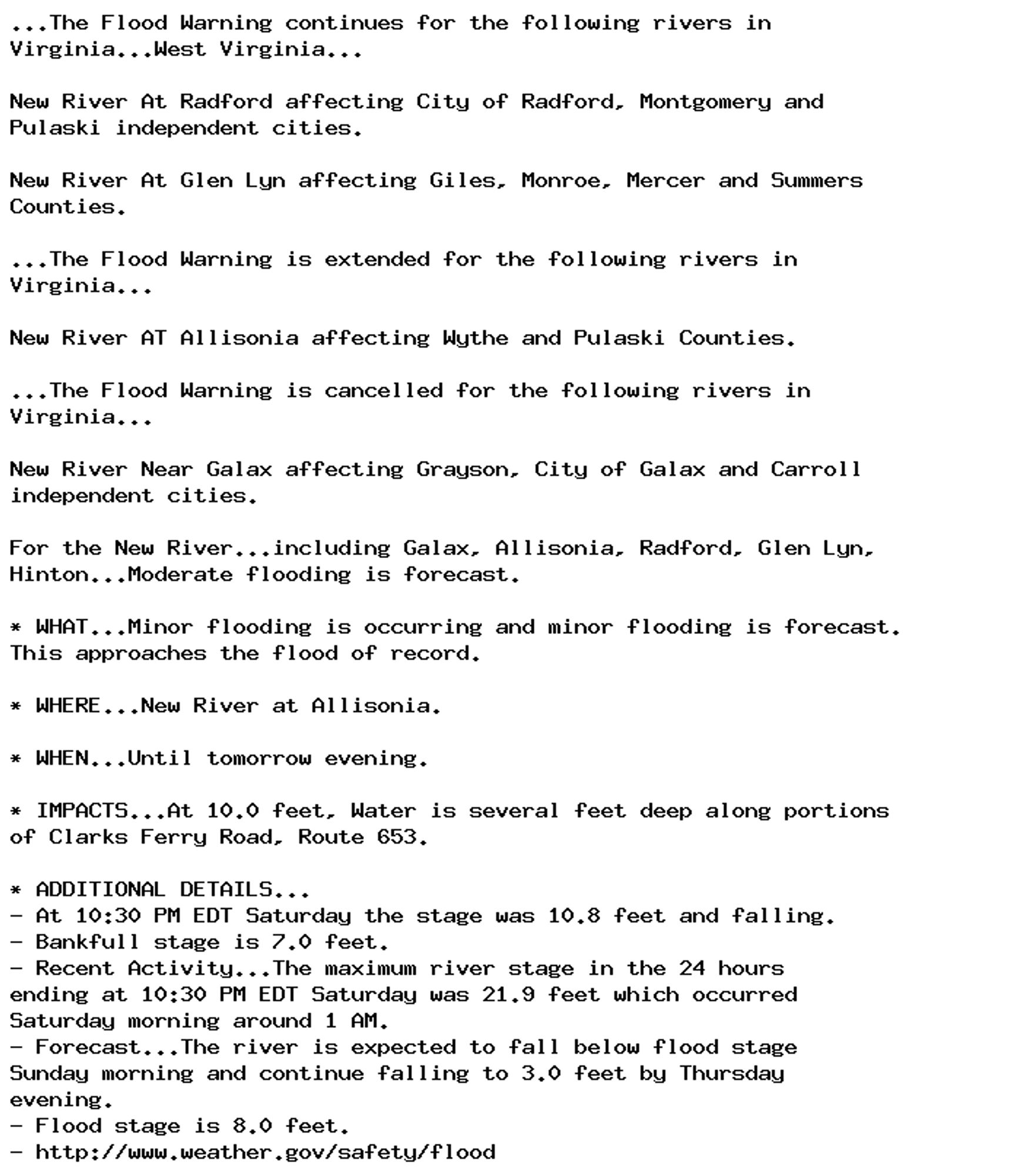
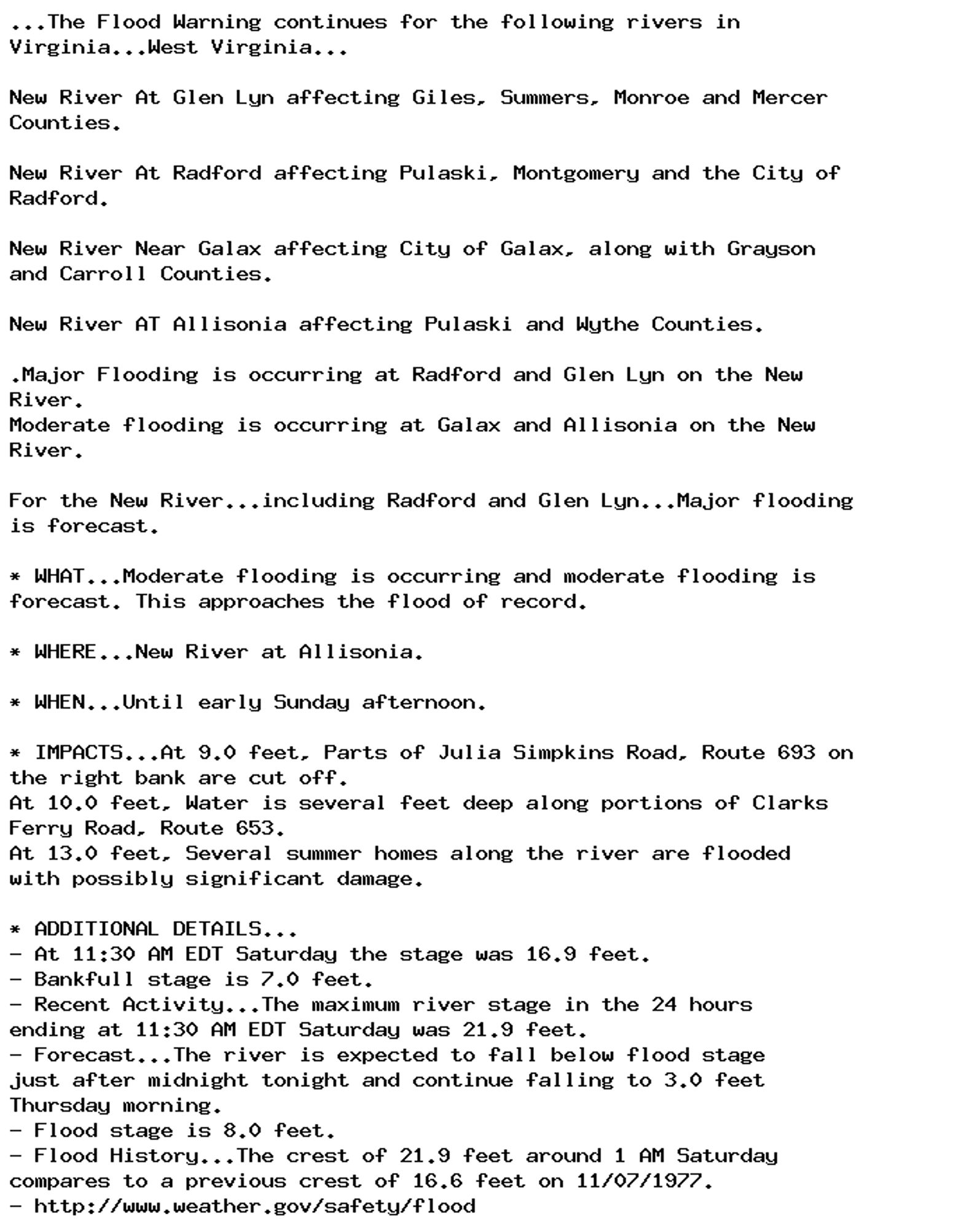
Flood Warning issued September 28 at 11:29PM EDT until September 29 at 7:38PM EDT by NWS Blacksburg VA Additional Details Here.

...The Flood Warning continues for the following rivers in
Virginia...West Virginia...

New River At Radford affecting City of Radford, Montgomery and
Pulaski independent cities.

New River At Glen Lyn affecting Giles, Monroe, Mercer and Summers
Counties.

...The Flood Warning is extended for the following rivers in
Virginia...

New River AT Allisonia affecting Wythe and Pulaski Counties.

...The Flood Warning is cancelled for the following rivers in
Virginia...

New River Near Galax affecting Grayson, City of Galax and Carroll
independent cities.

For the New River...including Galax, Allisonia, Radford, Glen Lyn,
Hinton...Moderate flooding is forecast.

* WHAT...Minor flooding is occurring and minor flooding is forecast.
This approaches the flood of record.

* WHERE...New River at Allisonia.

* WHEN...Until tomorrow evening.

* IMPACTS...At 10.0 feet, Water is several feet deep along portions
of Clarks Ferry Road, Route 653.

* ADDITIONAL DETAILS...
- At 10:30 PM EDT Saturday the stage was 10.8 feet and falling.
- Bankfull stage is 7.0 feet.
- Recent Activity...The maximum river stage in the 24 hours
ending at 10:30 PM EDT Saturday was 21.9 feet which occurred
Saturday morning around 1 AM.
- Forecast...The river is expected to fall below flood stage
Sunday morning and continue falling to 3.0 feet by Thursday
evening.
- Flood stage is 8.0 feet.
- http://www.weather.gov/safety/flood
0
AFcae.nws-bot.us

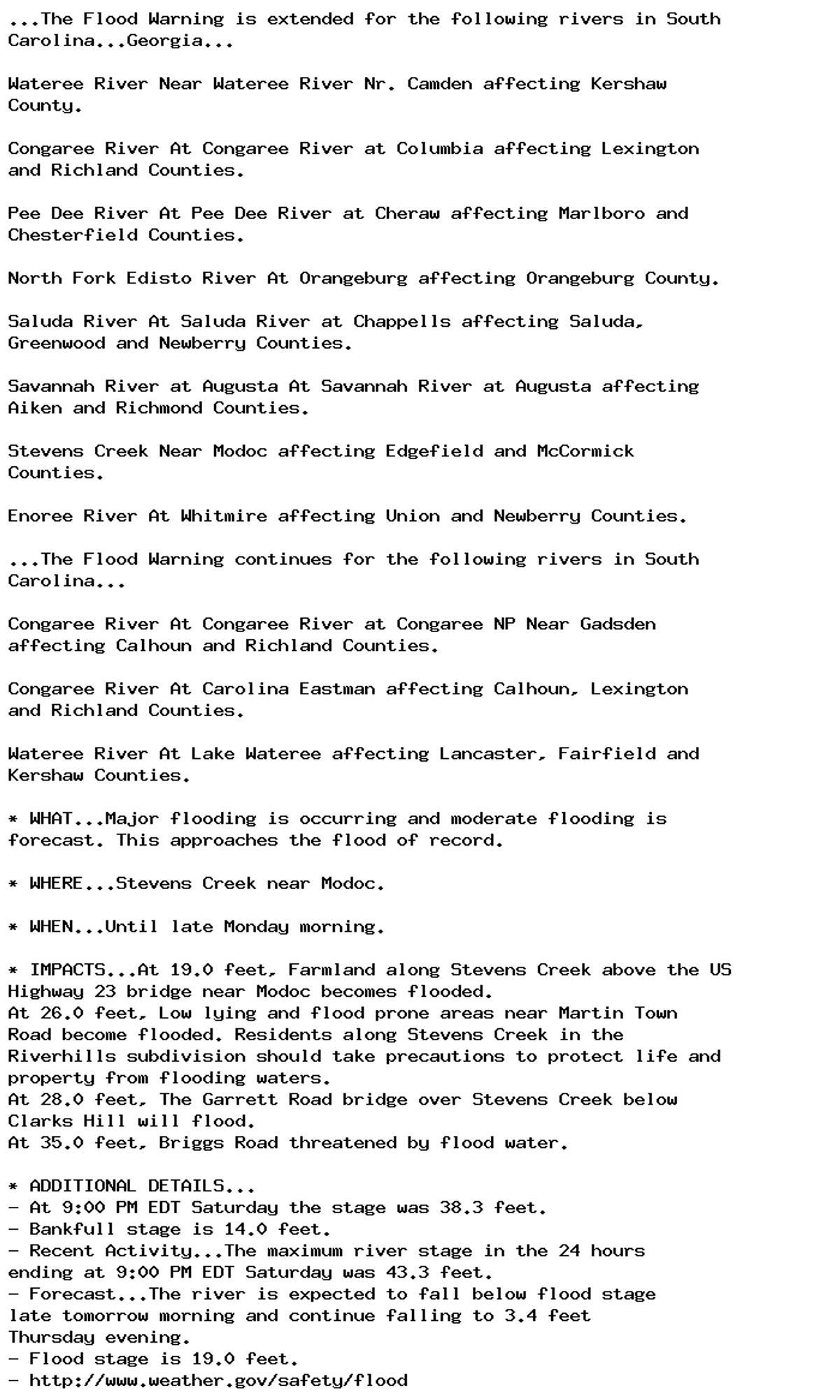
Flood Warning issued September 28 at 9:40PM EDT until September 30 at 9:51AM EDT by NWS Columbia SC Additional Details Here.

...The Flood Warning is extended for the following rivers in South
Carolina...Georgia...

Wateree River Near Wateree River Nr. Camden affecting Kershaw
County.

Congaree River At Congaree River at Columbia affecting Lexington
and Richland Counties.

Pee Dee River At Pee Dee River at Cheraw affecting Marlboro and
Chesterfield Counties.

North Fork Edisto River At Orangeburg affecting Orangeburg County.

Saluda River At Saluda River at Chappells affecting Saluda,
Greenwood and Newberry Counties.

Savannah River at Augusta At Savannah River at Augusta affecting
Aiken and Richmond Counties.

Stevens Creek Near Modoc affecting Edgefield and McCormick
Counties.

Enoree River At Whitmire affecting Union and Newberry Counties.

...The Flood Warning continues for the following rivers in South
Carolina...

Congaree River At Congaree River at Congaree NP Near Gadsden
affecting Calhoun and Richland Counties.

Congaree River At Carolina Eastman affecting Calhoun, Lexington
and Richland Counties.

Wateree River At Lake Wateree affecting Lancaster, Fairfield and
Kershaw Counties.

* WHAT...Major flooding is occurring and moderate flooding is
forecast. This approaches the flood of record.

* WHERE...Stevens Creek near Modoc.

* WHEN...Until late Monday morning.

* IMPACTS...At 19.0 feet, Farmland along Stevens Creek above the US
Highway 23 bridge near Modoc becomes flooded.
At 26.0 feet, Low lying and flood prone areas near Martin Town
Road become flooded. Residents along Stevens Creek in the
Riverhills subdivision should take precautions to protect life and
property from flooding waters.
At 28.0 feet, The Garrett Road bridge over Stevens Creek below
Clarks Hill will flood.
At 35.0 feet, Briggs Road threatened by flood water.

* ADDITIONAL DETAILS...
- At 9:00 PM EDT Saturday the stage was 38.3 feet.
- Bankfull stage is 14.0 feet.
- Recent Activity...The maximum river stage in the 24 hours
ending at 9:00 PM EDT Saturday was 43.3 feet.
- Forecast...The river is expected to fall below flood stage
late tomorrow morning and continue falling to 3.4 feet
Thursday evening.
- Flood stage is 19.0 feet.
- http://www.weather.gov/safety/flood
0
AFind.nws-bot.us

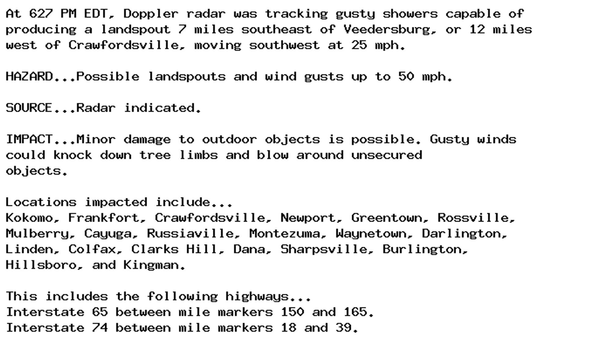
Special Weather Statement issued September 28 at 6:27PM EDT by NWS Indianapolis IN Additional Details Here.

At 627 PM EDT, Doppler radar was tracking gusty showers capable of
producing a landspout 7 miles southeast of Veedersburg, or 12 miles
west of Crawfordsville, moving southwest at 25 mph.

HAZARD...Possible landspouts and wind gusts up to 50 mph.

SOURCE...Radar indicated.

IMPACT...Minor damage to outdoor objects is possible. Gusty winds
could knock down tree limbs and blow around unsecured
objects.

Locations impacted include...
Kokomo, Frankfort, Crawfordsville, Newport, Greentown, Rossville,
Mulberry, Cayuga, Russiaville, Montezuma, Waynetown, Darlington,
Linden, Colfax, Clarks Hill, Dana, Sharpsville, Burlington,
Hillsboro, and Kingman.

This includes the following highways...
Interstate 65 between mile markers 150 and 165.
Interstate 74 between mile markers 18 and 39.
0
AFind.nws-bot.us

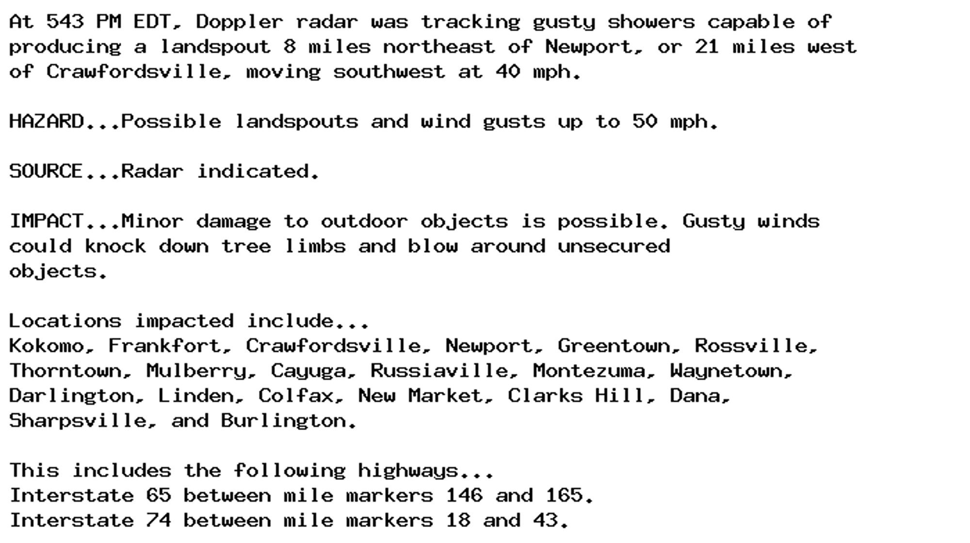
Special Weather Statement issued September 28 at 5:43PM EDT by NWS Indianapolis IN Additional Details Here.

At 543 PM EDT, Doppler radar was tracking gusty showers capable of
producing a landspout 8 miles northeast of Newport, or 21 miles west
of Crawfordsville, moving southwest at 40 mph.

HAZARD...Possible landspouts and wind gusts up to 50 mph.

SOURCE...Radar indicated.

IMPACT...Minor damage to outdoor objects is possible. Gusty winds
could knock down tree limbs and blow around unsecured
objects.

Locations impacted include...
Kokomo, Frankfort, Crawfordsville, Newport, Greentown, Rossville,
Thorntown, Mulberry, Cayuga, Russiaville, Montezuma, Waynetown,
Darlington, Linden, Colfax, New Market, Clarks Hill, Dana,
Sharpsville, and Burlington.

This includes the following highways...
Interstate 65 between mile markers 146 and 165.
Interstate 74 between mile markers 18 and 43.
0
AFrnk.nws-bot.us

🚨 Flood Warning issued September 28 at 1:02PM EDT until September 29 at 12:46PM EDT by NWS Blacksburg VA 🚨 Additional Details Here.

...The Flood Warning continues for the following rivers in
Virginia...West Virginia...

New River At Glen Lyn affecting Giles, Summers, Monroe and Mercer
Counties.

New River At Radford affecting Pulaski, Montgomery and the City of
Radford.

New River Near Galax affecting City of Galax, along with Grayson
and Carroll Counties.

New River AT Allisonia affecting Pulaski and Wythe Counties.

.Major Flooding is occurring at Radford and Glen Lyn on the New
River.
Moderate flooding is occurring at Galax and Allisonia on the New
River.

For the New River...including Radford and Glen Lyn...Major flooding
is forecast.

* WHAT...Moderate flooding is occurring and moderate flooding is
forecast. This approaches the flood of record.

* WHERE...New River at Allisonia.

* WHEN...Until early Sunday afternoon.

* IMPACTS...At 9.0 feet, Parts of Julia Simpkins Road, Route 693 on
the right bank are cut off.
At 10.0 feet, Water is several feet deep along portions of Clarks
Ferry Road, Route 653.
At 13.0 feet, Several summer homes along the river are flooded
with possibly significant damage.

* ADDITIONAL DETAILS...
- At 11:30 AM EDT Saturday the stage was 16.9 feet.
- Bankfull stage is 7.0 feet.
- Recent Activity...The maximum river stage in the 24 hours
ending at 11:30 AM EDT Saturday was 21.9 feet.
- Forecast...The river is expected to fall below flood stage
just after midnight tonight and continue falling to 3.0 feet
Thursday morning.
- Flood stage is 8.0 feet.
- Flood History...The crest of 21.9 feet around 1 AM Saturday
compares to a previous crest of 16.6 feet on 11/07/1977.
- http://www.weather.gov/safety/flood
0
AFcae.nws-bot.us

🚨 Flood Warning issued September 28 at 11:36AM EDT until September 30 at 6:30AM EDT by NWS Columbia SC 🚨 Additional Details Here.

...The Flood Warning is extended for the following rivers in South
Carolina...

Wateree River Near Wateree River Nr. Camden affecting Kershaw
County.

Congaree River At Congaree River at Columbia affecting Lexington
and Richland Counties.

North Fork Edisto River At Orangeburg affecting Orangeburg County.

Saluda River At Saluda River at Chappells affecting Newberry,
Greenwood and Saluda Counties.

...The Flood Warning continues for the following rivers in South
Carolina...Georgia...

Pee Dee River At Pee Dee River at Cheraw affecting Chesterfield
and Marlboro Counties.

Savannah River at Augusta At Savannah River at Augusta affecting
Aiken and Richmond Counties.

Stevens Creek Near Modoc affecting Edgefield and McCormick
Counties.

Enoree River At Whitmire affecting Newberry and Union Counties.

Congaree River At Congaree River at Congaree NP Near Gadsden
affecting Richland and Calhoun Counties.

Congaree River At Carolina Eastman affecting Lexington, Richland
and Calhoun Counties.

Wateree River At Lake Wateree affecting Kershaw, Fairfield and
Lancaster Counties.

* WHAT...Major flooding is occurring and major flooding is forecast.
This approaches the flood of record.

* WHERE...Stevens Creek near Modoc.

* WHEN...Until Monday morning.

* IMPACTS...At 19.0 feet, Farmland along Stevens Creek above the US
Highway 23 bridge near Modoc becomes flooded.
At 26.0 feet, Low lying and flood prone areas near Martin Town
Road become flooded. Residents along Stevens Creek in the
Riverhills subdivision should take precautions to protect life and
property from flooding waters.
At 28.0 feet, The Garrett Road bridge over Stevens Creek below
Clarks Hill will flood.
At 35.0 feet, Briggs Road threatened by flood water.
At 41.0 feet, Extensive farmland and bottomland along Stevens
Creek near Modoc and Clarks Hill become flooded.

* ADDITIONAL DETAILS...
- At 10:00 AM EDT Saturday the stage was 42.8 feet.
- Bankfull stage is 14.0 feet.
- Recent Activity...The maximum river stage in the 24 hours
ending at 10:00 AM EDT Saturday was 43.3 feet.
- Forecast...The river has crested and will slowly fall this
afternoon before rapidly receding later tonight and expected
to fall below flood stage Sunday morning and continue falling
to around 6 feet Sunday night.
- Flood stage is 19.0 feet.
- http://www.weather.gov/safety/flood
0
AFrnk.nws-bot.us

🚨 Flood Warning issued September 28 at 9:25AM EDT until September 29 at 6:12PM EDT by NWS Blacksburg VA 🚨 Additional Details Here.

...The Flood Warning is extended for the following rivers in
Virginia...West Virginia...

New River At Glen Lyn affecting Giles, Summers, Monroe and Mercer
Counties.

New River At Radford affecting Pulaski, Montgomery and City of
Radford independent cities.

New River AT Allisonia affecting Pulaski and Wythe Counties.

...The Flood Warning continues for the following rivers in
Virginia...

New River Near Galax affecting City of Galax, Grayson and Carroll
independent cities.

For the New River...including Galax, Allisonia, Radford, Glen Lyn,
Hinton...Major flooding is forecast.

* WHAT...Major flooding is occurring and major flooding is forecast.
This approaches the flood of record.

* WHERE...New River at Allisonia.

* WHEN...Until tomorrow evening.

* IMPACTS...At 10.0 feet, Water is several feet deep along portions
of Clarks Ferry Road, Route 653.
At 13.0 feet, Several summer homes along the river are flooded
with possibly significant damage.

* ADDITIONAL DETAILS...
- At 8:30 AM EDT Saturday the stage was 19.5 feet.
- Bankfull stage is 7.0 feet.
- Recent Activity...The maximum river stage in the 24 hours
ending at 8:30 AM EDT Saturday was 21.9 feet.
- Forecast...The river is expected to fall below flood stage
tomorrow morning and continue falling to 3.1 feet Wednesday
evening.
- Flood stage is 8.0 feet.
- Flood History...This crest compares to a previous crest of
23.4 feet on 08/14/1940.
- http://www.weather.gov/safety/flood
0