BLUE
lazear.bsky.social

We definitely saw that with the Columbia office takeover. A lot of the response was over the top, but like any kid who thought they were walking away from breaking into an office with a light slap on the wrist were severely disappointed.

0
CAchris2fur1943.bsky.social

The Greens are the first of the three major parties to release their platform for British Columbia. It highlights the need for a shift to a “well-being framework”. thetyee.ca/News/2024/10...

Green Platform Proposes New Direction for BC | The Tyee

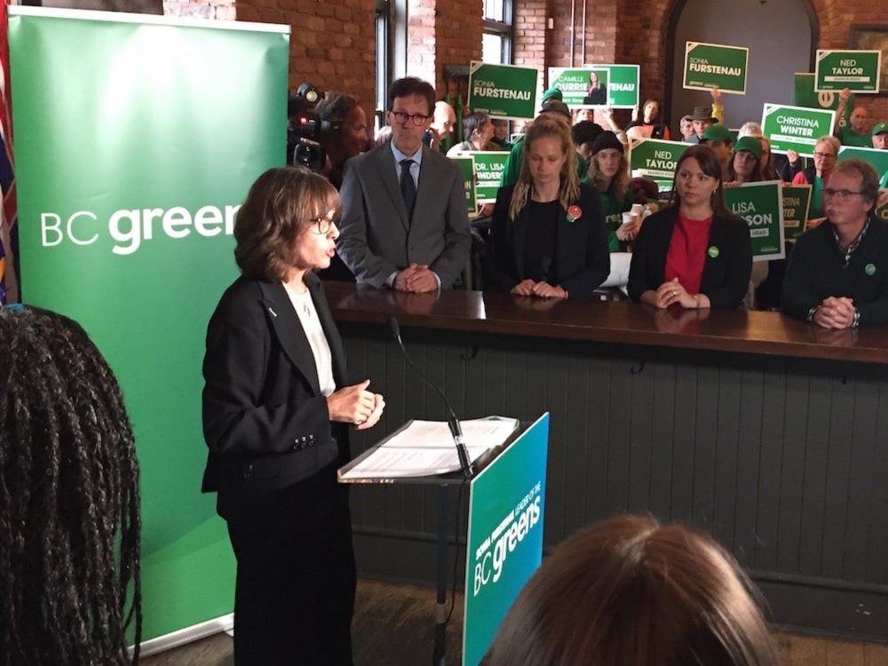
Party promises proportional representation, vacancy control, better health care and a new focus on well-being.

0
TJtrumpjet.grndcntrl.net

Vance's Charter Jet (N917XA) Took off from Washington, District of Columbia, United States.

Reg: N917XA On Ground: False Alt: -50 Last Contact: 0:00:00.100652 Trigger: no longer on ground
0
Vcokerant.bsky.social

por enquanto columbia e atlantic tem sido mães mas vamos ver as promoções pós-lançamento

0
AFcae.nws-bot.us

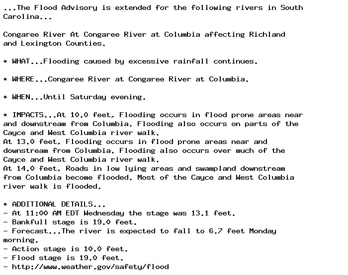
Flood Advisory issued October 2 at 11:49AM EDT until October 5 at 8:00PM EDT by NWS Columbia SC Additional Details Here.

...The Flood Advisory is extended for the following rivers in South
Carolina...

Congaree River At Congaree River at Columbia affecting Richland
and Lexington Counties.

* WHAT...Flooding caused by excessive rainfall continues.

* WHERE...Congaree River at Congaree River at Columbia.

* WHEN...Until Saturday evening.

* IMPACTS...At 10.0 feet, Flooding occurs in flood prone areas near
and downstream from Columbia. Flooding also occurs on parts of the
Cayce and West Columbia river walk.
At 13.0 feet, Flooding occurs in flood prone areas near and
downstream from Columbia. Flooding also occurs over much of the
Cayce and West Columbia river walk.
At 14.0 feet, Roads in low lying areas and swampland downstream
from Columbia become flooded. Most of the Cayce and West Columbia
river walk is flooded.

* ADDITIONAL DETAILS...
- At 11:00 AM EDT Wednesday the stage was 13.1 feet.
- Bankfull stage is 19.0 feet.
- Forecast...The river is expected to fall to 6.7 feet Monday
morning.
- Action stage is 10.0 feet.
- Flood stage is 19.0 feet.
- http://www.weather.gov/safety/flood
0
AFcae.nws-bot.us

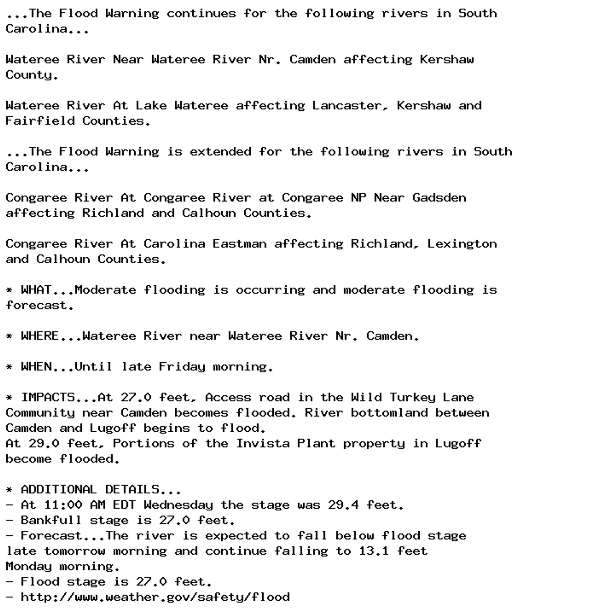
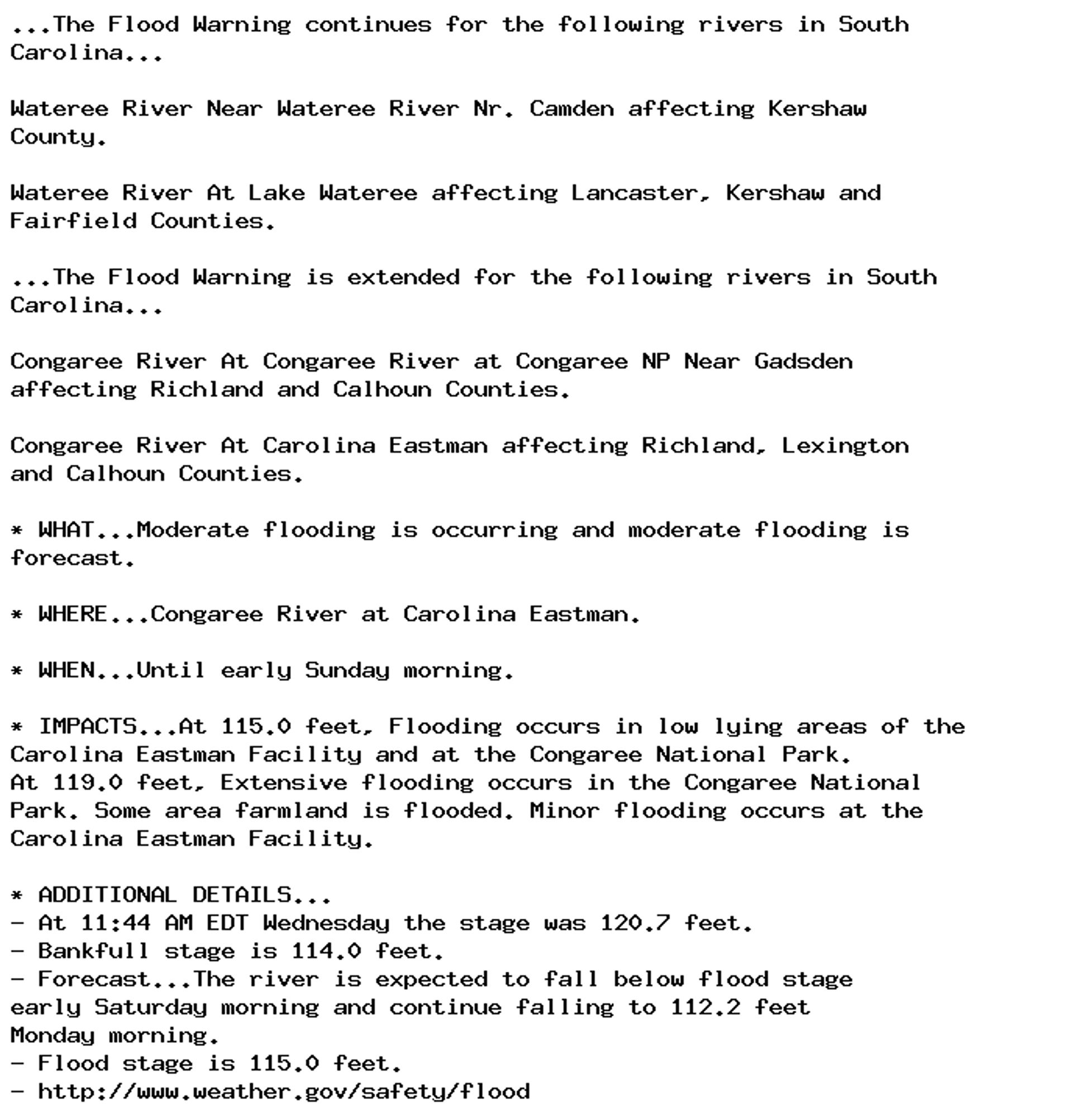
🚨 Flood Warning issued October 2 at 11:49AM EDT until October 4 at 11:36AM EDT by NWS Columbia SC 🚨 Additional Details Here.

...The Flood Warning continues for the following rivers in South
Carolina...

Wateree River Near Wateree River Nr. Camden affecting Kershaw
County.

Wateree River At Lake Wateree affecting Lancaster, Kershaw and
Fairfield Counties.

...The Flood Warning is extended for the following rivers in South
Carolina...

Congaree River At Congaree River at Congaree NP Near Gadsden
affecting Richland and Calhoun Counties.

Congaree River At Carolina Eastman affecting Richland, Lexington
and Calhoun Counties.

* WHAT...Moderate flooding is occurring and moderate flooding is
forecast.

* WHERE...Wateree River near Wateree River Nr. Camden.

* WHEN...Until late Friday morning.

* IMPACTS...At 27.0 feet, Access road in the Wild Turkey Lane
Community near Camden becomes flooded. River bottomland between
Camden and Lugoff begins to flood.
At 29.0 feet, Portions of the Invista Plant property in Lugoff
become flooded.

* ADDITIONAL DETAILS...
- At 11:00 AM EDT Wednesday the stage was 29.4 feet.
- Bankfull stage is 27.0 feet.
- Forecast...The river is expected to fall below flood stage
late tomorrow morning and continue falling to 13.1 feet
Monday morning.
- Flood stage is 27.0 feet.
- http://www.weather.gov/safety/flood
0
AFcae.nws-bot.us

🚨 Flood Warning issued October 2 at 11:49AM EDT until October 5 at 5:00PM EDT by NWS Columbia SC 🚨 Additional Details Here.

...The Flood Warning continues for the following rivers in South
Carolina...

Wateree River Near Wateree River Nr. Camden affecting Kershaw
County.

Wateree River At Lake Wateree affecting Lancaster, Kershaw and
Fairfield Counties.

...The Flood Warning is extended for the following rivers in South
Carolina...

Congaree River At Congaree River at Congaree NP Near Gadsden
affecting Richland and Calhoun Counties.

Congaree River At Carolina Eastman affecting Richland, Lexington
and Calhoun Counties.

* WHAT...Minor flooding is occurring and minor flooding is forecast.

* WHERE...Wateree River at Lake Wateree.

* WHEN...Until Saturday afternoon.

* IMPACTS...At 100.4 feet, The piers on the Wildlife Road bridge
over Singleton Creek become submerged.
At 102.5 feet, Roadways near Beaver Creek become flooded.


* ADDITIONAL DETAILS...
- At 10:00 AM EDT Wednesday the stage was 101.7 feet.
- Bankfull stage is 100.0 feet.
- Forecast...The river is expected to fall below flood stage
Friday afternoon and continue falling to 99.1 feet Monday
morning.
- Flood stage is 100.0 feet.
- http://www.weather.gov/safety/flood
0
AFcae.nws-bot.us

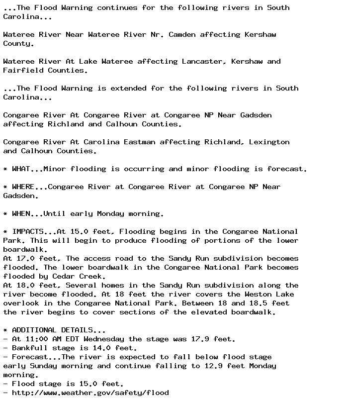
🚨 Flood Warning issued October 2 at 11:49AM EDT until October 6 at 5:31AM EDT by NWS Columbia SC 🚨 Additional Details Here.

...The Flood Warning continues for the following rivers in South
Carolina...

Wateree River Near Wateree River Nr. Camden affecting Kershaw
County.

Wateree River At Lake Wateree affecting Lancaster, Kershaw and
Fairfield Counties.

...The Flood Warning is extended for the following rivers in South
Carolina...

Congaree River At Congaree River at Congaree NP Near Gadsden
affecting Richland and Calhoun Counties.

Congaree River At Carolina Eastman affecting Richland, Lexington
and Calhoun Counties.

* WHAT...Moderate flooding is occurring and moderate flooding is
forecast.

* WHERE...Congaree River at Carolina Eastman.

* WHEN...Until early Sunday morning.

* IMPACTS...At 115.0 feet, Flooding occurs in low lying areas of the
Carolina Eastman Facility and at the Congaree National Park.
At 119.0 feet, Extensive flooding occurs in the Congaree National
Park. Some area farmland is flooded. Minor flooding occurs at the
Carolina Eastman Facility.

* ADDITIONAL DETAILS...
- At 11:44 AM EDT Wednesday the stage was 120.7 feet.
- Bankfull stage is 114.0 feet.
- Forecast...The river is expected to fall below flood stage
early Saturday morning and continue falling to 112.2 feet
Monday morning.
- Flood stage is 115.0 feet.
- http://www.weather.gov/safety/flood
0
AFcae.nws-bot.us

🚨 Flood Warning issued October 2 at 11:49AM EDT until October 7 at 1:15AM EDT by NWS Columbia SC 🚨 Additional Details Here.

...The Flood Warning continues for the following rivers in South
Carolina...

Wateree River Near Wateree River Nr. Camden affecting Kershaw
County.

Wateree River At Lake Wateree affecting Lancaster, Kershaw and
Fairfield Counties.

...The Flood Warning is extended for the following rivers in South
Carolina...

Congaree River At Congaree River at Congaree NP Near Gadsden
affecting Richland and Calhoun Counties.

Congaree River At Carolina Eastman affecting Richland, Lexington
and Calhoun Counties.

* WHAT...Minor flooding is occurring and minor flooding is forecast.

* WHERE...Congaree River at Congaree River at Congaree NP Near
Gadsden.

* WHEN...Until early Monday morning.

* IMPACTS...At 15.0 feet, Flooding begins in the Congaree National
Park. This will begin to produce flooding of portions of the lower
boardwalk.
At 17.0 feet, The access road to the Sandy Run subdivision becomes
flooded. The lower boardwalk in the Congaree National Park becomes
flooded by Cedar Creek.
At 18.0 feet, Several homes in the Sandy Run subdivision along the
river become flooded. At 18 feet the river covers the Weston Lake
overlook in the Congaree National Park. Between 18 and 18.5 feet
the river begins to cover sections of the elevated boardwalk.

* ADDITIONAL DETAILS...
- At 11:00 AM EDT Wednesday the stage was 17.9 feet.
- Bankfull stage is 14.0 feet.
- Forecast...The river is expected to fall below flood stage
early Sunday morning and continue falling to 12.9 feet Monday
morning.
- Flood stage is 15.0 feet.
- http://www.weather.gov/safety/flood
0
Jjackpfvr.bsky.social

continue columbia records

0