BLUE
NCnwschicago.bsky.social

Dry conditions will continue through the remainder of the week. There may be an opportunity for light showers or sprinkles this weekend, though meaningful rainfall is not expected. After unseasonable warmth on Friday, cooler temperatures will return over the weekend. #ilwx#inwx

This is a multiday forecast graphic for northern Illinois and northwest Indiana.  Headline: Five Day Forecast.  Sub Headline: Continued dry conditions into the weekend; unseasonably warm on Friday.  Visit weather.gov/Chicago for more forecast details for your location. Graphic Created: Tuesday, October 8, 2024 2:31 PM CDT
0
NCnwschicago.bsky.social

Abundant sunshine is expected through the week and into the weekend with near to above normal temperatures otherwise. The warmest day of the week is expected to be on Friday where temperatures are expected to top out in the 80s. #ILwx#INwx

This is a multiday forecast graphic for northern Illinois and northwest Indiana.  Headline: Five Day Forecast.  Sub Headline: Dry pattern to continue with near to above normal temperatures.  Visit weather.gov/Chicago for more forecast details for your location.    Graphic Created: Tuesday, October 8, 2024 4:26 AM CDT
0
NCnwschicago.bsky.social

Patchy frost may develop in some locations outside of the Chicago metro tonight. Dry weather and abundant sunshine will then continue through the week and into the weekend, accompanied by near to above normal temperatures that should peak on Friday. #ilwx#inwx

This is a multiday forecast graphic for northern Illinois and northwest Indiana.  Headline: Five Day Outlook.  Sub Headline: Dry pattern to continue with near to above normal temperatures.  Visit weather.gov/Chicago for more forecast details for your location. Graphic Created: Monday, October 7, 2024 2:08 PM CDT
0
NCnwschicago.bsky.social

Our stretch of dry weather will persist through the week and likely into next weekend as well. While temperatures will start off cooler today and Tuesday, above normal temperatures are expected to return towards weeks end. #ILwx#INwx

This is a multiday forecast graphic for northern Illinois and northwest Indiana.  Headline: Work Week Forecast.  Sub Headline: Cooler start to the week but temperatures warm above normal again mid-late week. Visit weather.gov/Chicago for more forecast details for your location.    Graphic Created: Monday, October 7, 2024 4:02 AM CDT
0
NCnwschicago.bsky.social

Dry weather will persist through the coming week, with temperatures briefly near normal Monday, then warming above average again mid and late week. #ILwx#INwx

This is a multi-day forecast graphic for northern Illinois and northwest Indiana.  Headline: Dry Pattern Continues This Week.  Sub Headline: Cooler start to the week but temperatures warm above normal again mid-late week. Visit weather.gov/Chicago for more forecast details for your location. Graphic Created: Sunday, October 6, 2024 3:20 PM CDT.
0
NCnwschicago.bsky.social

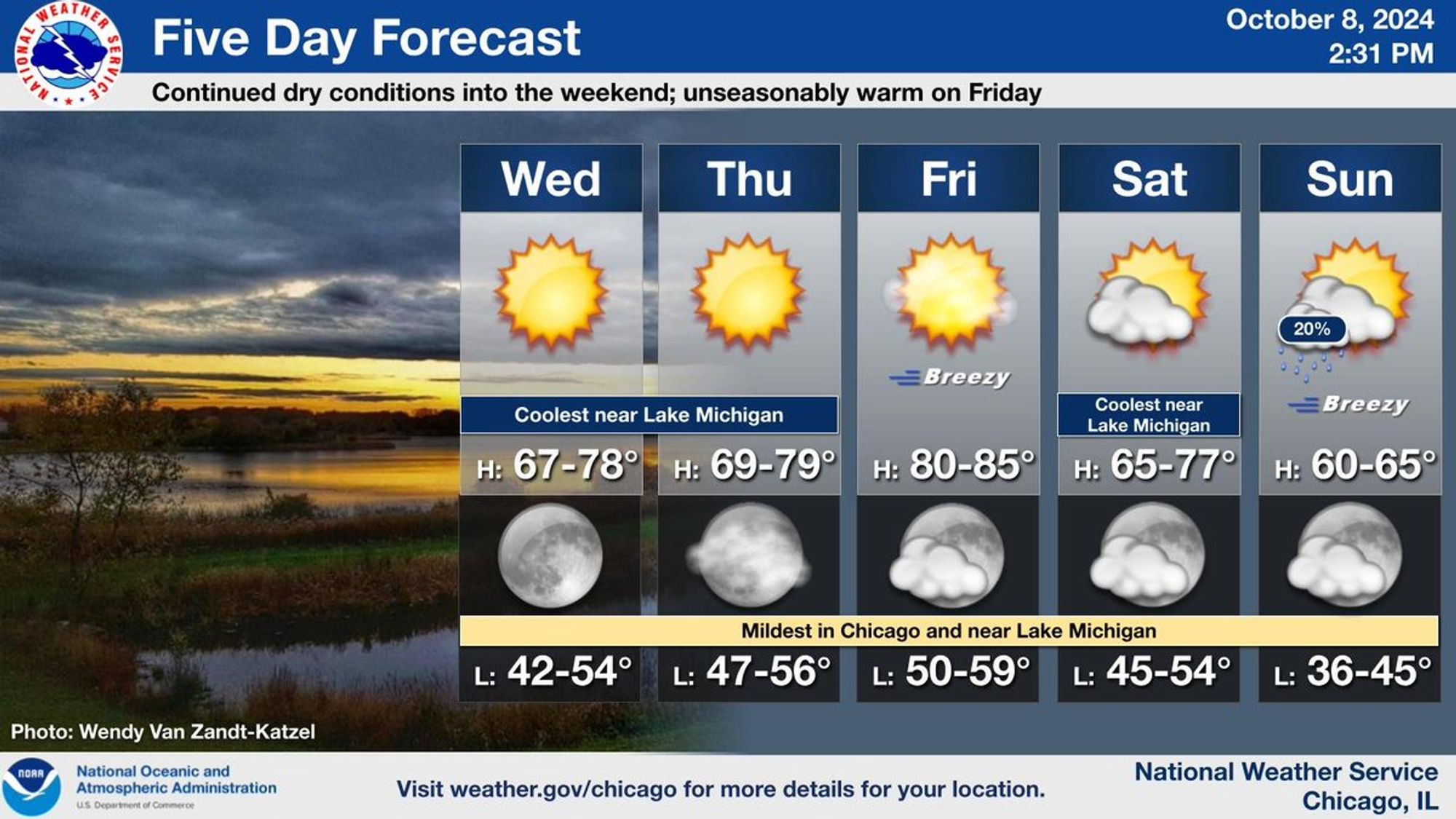
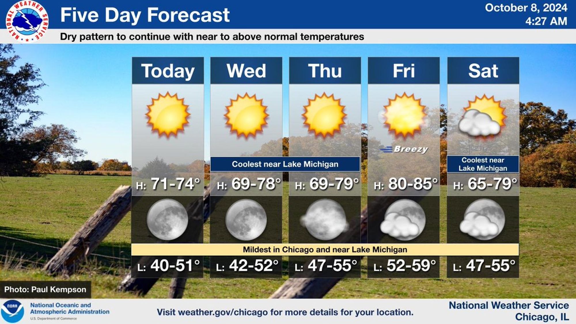
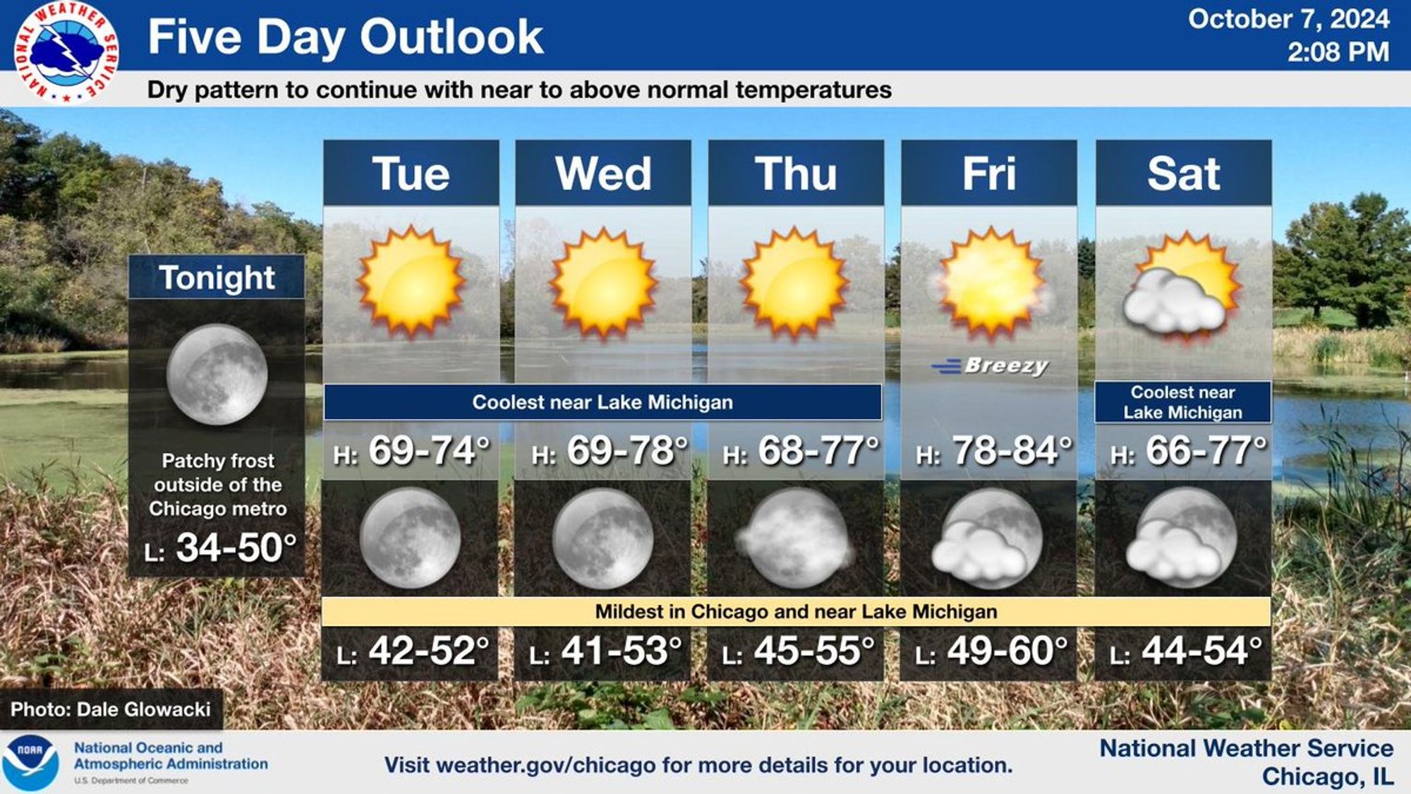
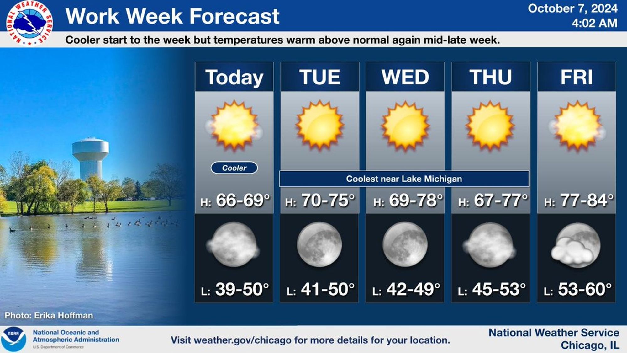
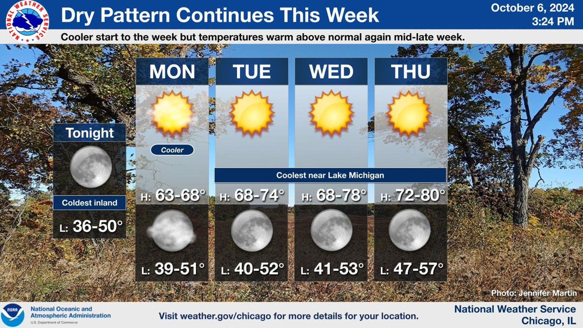
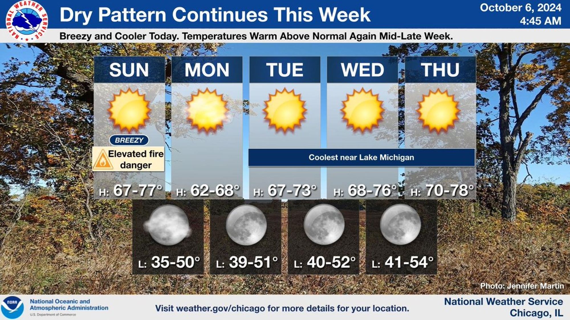
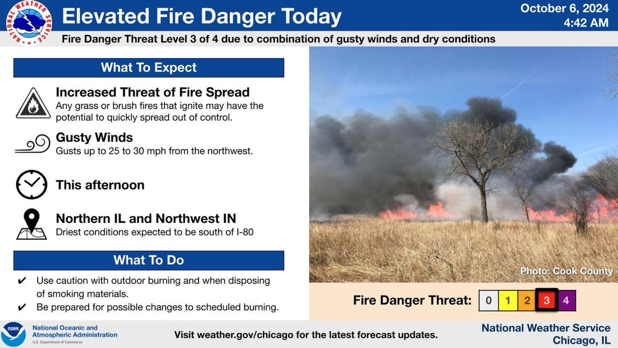
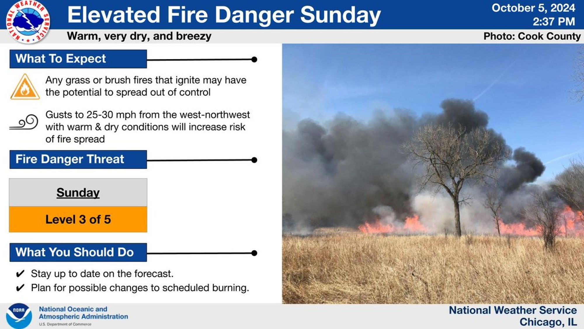
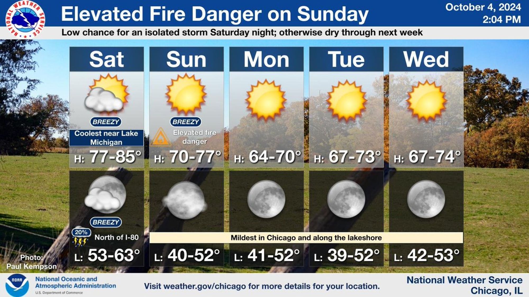
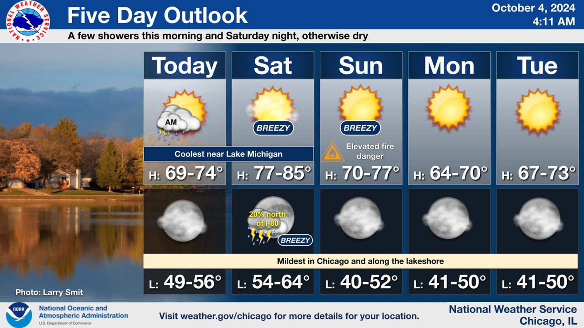
Breezy conditions, along with lower humidity levels, will bring an elevated threat for grass and brush fires to start and spread today. Dry weather will persist through the coming week, with temps briefly near normal Mon, then warming above average again late week. #ILwx#INwx

This is a multiday forecast graphic for northern Illinois and northwest Indiana.  Headline: Dry Pattern Continues This Week.  Sub Headline: Breezy and Cooler Today. Temperatures Warm Above Normal Again Mid-Late Week. Visit weather.gov/Chicago for more forecast details for your location.    Graphic Created: Sunday, October 6, 2024 4:34 AM CDT
0
NCnwschicago.bsky.social

The combination of dry conditions and gusty northwest winds to 30 mph will lead to an increased risk for grass and brush fire spread this afternoon. Be sure to use extra caution when disposing of smoking materials and avoid burning if possible. #ILwx#INwx

Headline: Elevated Fire Danger Today.  Sub Headline: Fire Danger Threat Level 3 of 4 due to combination of gusty winds and dry conditions. What To Expect: Increased Threat of Fire Spread.  Any grass or brush fires that ignite may have the potential to quickly spread out of control.  Gusty Winds. Gusts up to 25 to 30 mph from the northwest. When: This Afternoon. Where: Northern IL and Northwest IN.  Driest conditions expected to be south of I-80.  What To Do: Use caution with outdoor burning and when disposing of smoking materials. Be prepared for possible changes to scheduled burning.  Graphic Created: Sunday, October 6, 2024 4:34 AM CDT
0
NCnwschicago.bsky.social

Dry and warm conditions with southwest winds gusting to 30 mph Sunday afternoon will lead to a heightened risk of grass/brush fires igniting and rapidly spreading out of control. Take extra caution if burning on Sunday or, better yet, avoid it altogether! #ILwx#INwx

Headline: Elevated Fire Danger Sunday.  Sub Headline: Warm, very dry, and breezy.  What To Expect: Any grass or brush fires that ignite may have the potential to spread out of control.  Gusts to 25-30 mph from the west-northwest with warm and dry conditions will increase risk of fire spread.  Fire Danger Threat: level 3 out of 5.  What You Should Do.   Stay up to date on the forecast.  Plan for possible changes to scheduled burning.   Graphic Created: Saturday, October 5, 2024 2:29 PM CDT
0
NCnwschicago.bsky.social

Dry and breezy conditions will bring an elevated threat for fires to start and spread on Sunday. Outside of a low chance for an isolated thunderstorm north of I-80 Saturday night, no precipitation is expected in the foreseeable future. #ilwx#inwx

This is a multiday forecast graphic for northern Illinois and northwest Indiana.  Headline: Elevated Fire Danger on Sunday.  Sub Headline: Low chance for an isolated storm Saturday night; otherwise dry through next week. Visit weather.gov/Chicago for more forecast details for your location. Graphic Created: Friday, October 4, 2024 2:04 PM CDT
0
NCnwschicago.bsky.social

Aside from a few showers and isolated t-storms this morning and the chance for showers and t-storms Sat night, dry weather is expected with above normal temps. An elevated fire danger is likely on Sun due to the combination of gusty winds and dry conditions. #ILwx#INwx

This is a multiday forecast graphic for northern Illinois and northwest Indiana.  Headline: Five Day Outlook.  Sub Headline: A few showers this morning and Saturday night, otherwise dry.  Visit weather.gov/Chicago for more forecast details for your location.    Graphic Created: Friday, October 4, 2024 4:10 AM CDT
0