BLUE
Eedithraphaela.bsky.social

Vermelden Nr. 2: Ellie hat geschlafen, gesnackt + ist wohlauf, aber ich bin mir nochnich ganz sicher + behalt den Helikopter-Modus an. Notfalls nochmal Besuch bei der Tierärztin die Woche (Achtung Donnerstag ist Feiertag!), gleich ist die ganze Wäsche gewaschen + ein kl. neuer Kratzbaum is bestellt.

1
WNheikewhynot.bsky.social

#grüne#grünejugend Und Landesverband Nr. 6, diesmal Hamburg. Bei der Grünen Partei: Schweigen oder nachtreten. Erstaunlich. „Fast der ganze Hamburger Vorstand der Grünen Jugend kündigt den Austritt an. Damit tut er es dem Bundesvorstand der Organisation und den Spitzen in fünf Ländern gleich.“:

Bündnis 90/Die Grünen: Auch Vorstand der Grünen Jugend Hamburg will Partei verlassen

Fast der ganze Hamburger Vorstand der Grünen Jugend kündigt den Austritt an. Damit tut er es dem Bundesvorstand der Organisation und den Spitzen in fünf Ländern gleich.

0
AFcae.nws-bot.us

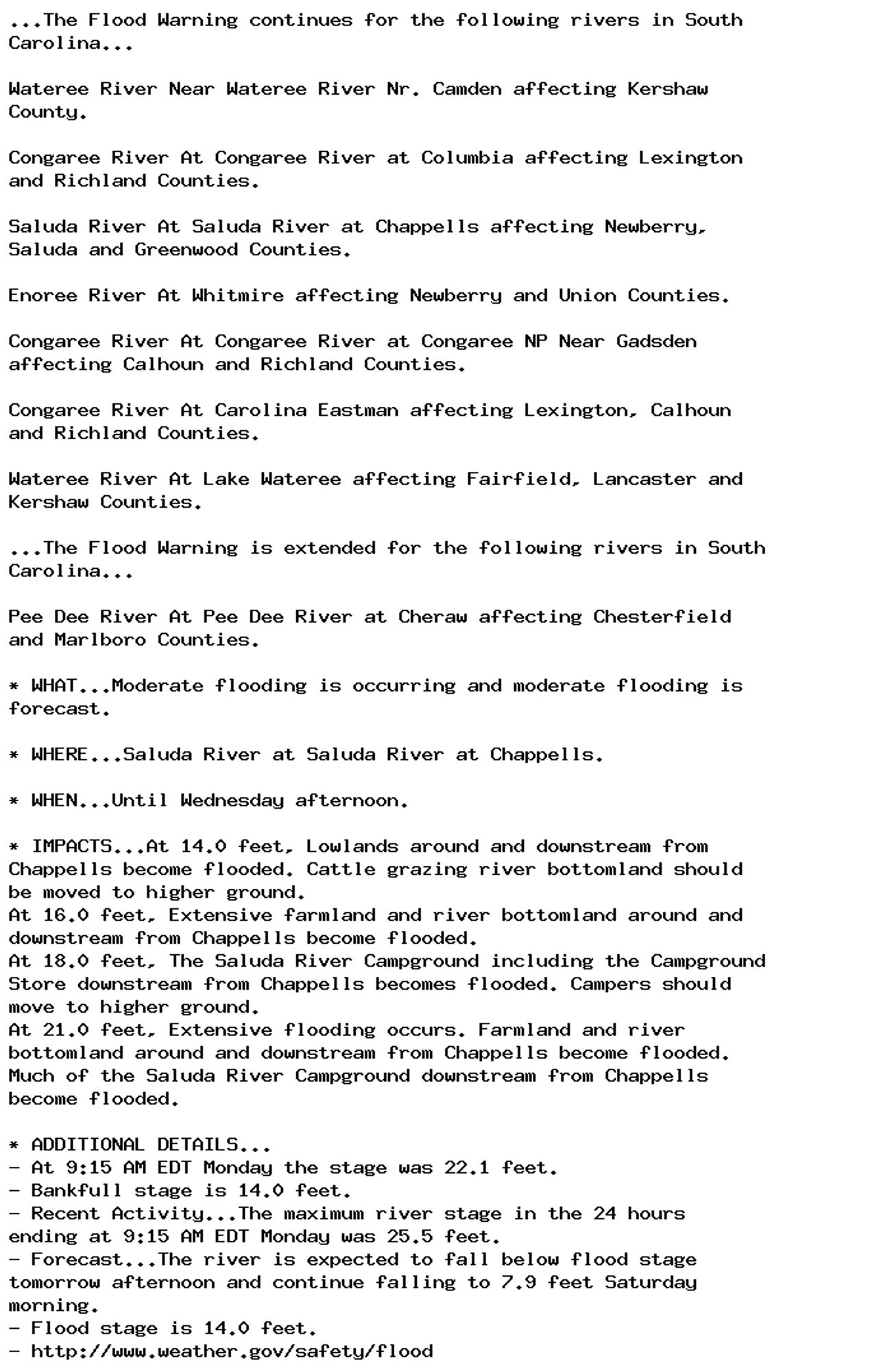
🚨 Flood Warning issued September 30 at 10:30AM EDT until October 2 at 10:15PM EDT by NWS Columbia SC 🚨 Additional Details Here.

...The Flood Warning continues for the following rivers in South
Carolina...

Wateree River Near Wateree River Nr. Camden affecting Kershaw
County.

Congaree River At Congaree River at Columbia affecting Lexington
and Richland Counties.

Saluda River At Saluda River at Chappells affecting Newberry,
Saluda and Greenwood Counties.

Enoree River At Whitmire affecting Newberry and Union Counties.

Congaree River At Congaree River at Congaree NP Near Gadsden
affecting Calhoun and Richland Counties.

Congaree River At Carolina Eastman affecting Lexington, Calhoun
and Richland Counties.

Wateree River At Lake Wateree affecting Fairfield, Lancaster and
Kershaw Counties.

...The Flood Warning is extended for the following rivers in South
Carolina...

Pee Dee River At Pee Dee River at Cheraw affecting Chesterfield
and Marlboro Counties.

* WHAT...Minor flooding is occurring and minor flooding is forecast.

* WHERE...Pee Dee River at Pee Dee River at Cheraw.

* WHEN...Until late Wednesday evening.

* IMPACTS...At 20.0 feet, River bottomland downstream from cheraw
will begin to flood.
At 30.0 feet, The higher bank begins to flood. Large areas of
farmland and river bottomland near Cheraw will be flooded.
Portions of Riverside Park become flooded.
At 33.0 feet, Southeast of Wallace, water spreads onto Old River
Road between Community Road and Highway 912.
At 35.0 feet, Southeast of Wallace, Old River Road between
Community Road and Highway 912 will become flooded and may need to
be closed.

* ADDITIONAL DETAILS...
- At 9:15 AM EDT Monday the stage was 33.2 feet.
- Bankfull stage is 20.0 feet.
- Recent Activity...The maximum river stage in the 24 hours
ending at 9:15 AM EDT Monday was 33.6 feet.
- Forecast...The river is expected to fall below flood stage
late tomorrow evening and continue falling to 12.5 feet
Saturday morning.
- Flood stage is 30.0 feet.
- http://www.weather.gov/safety/flood
0
AFcae.nws-bot.us

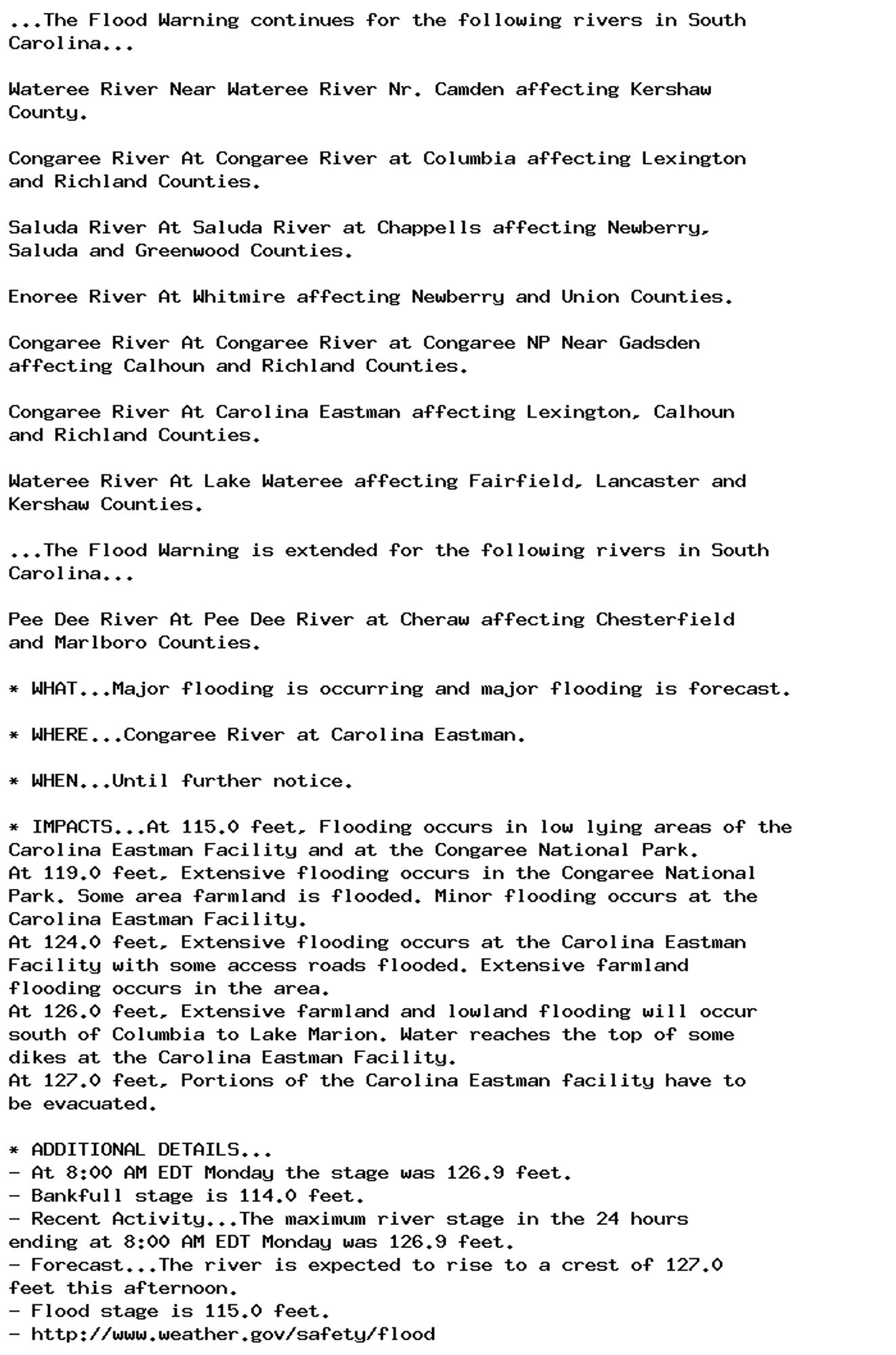
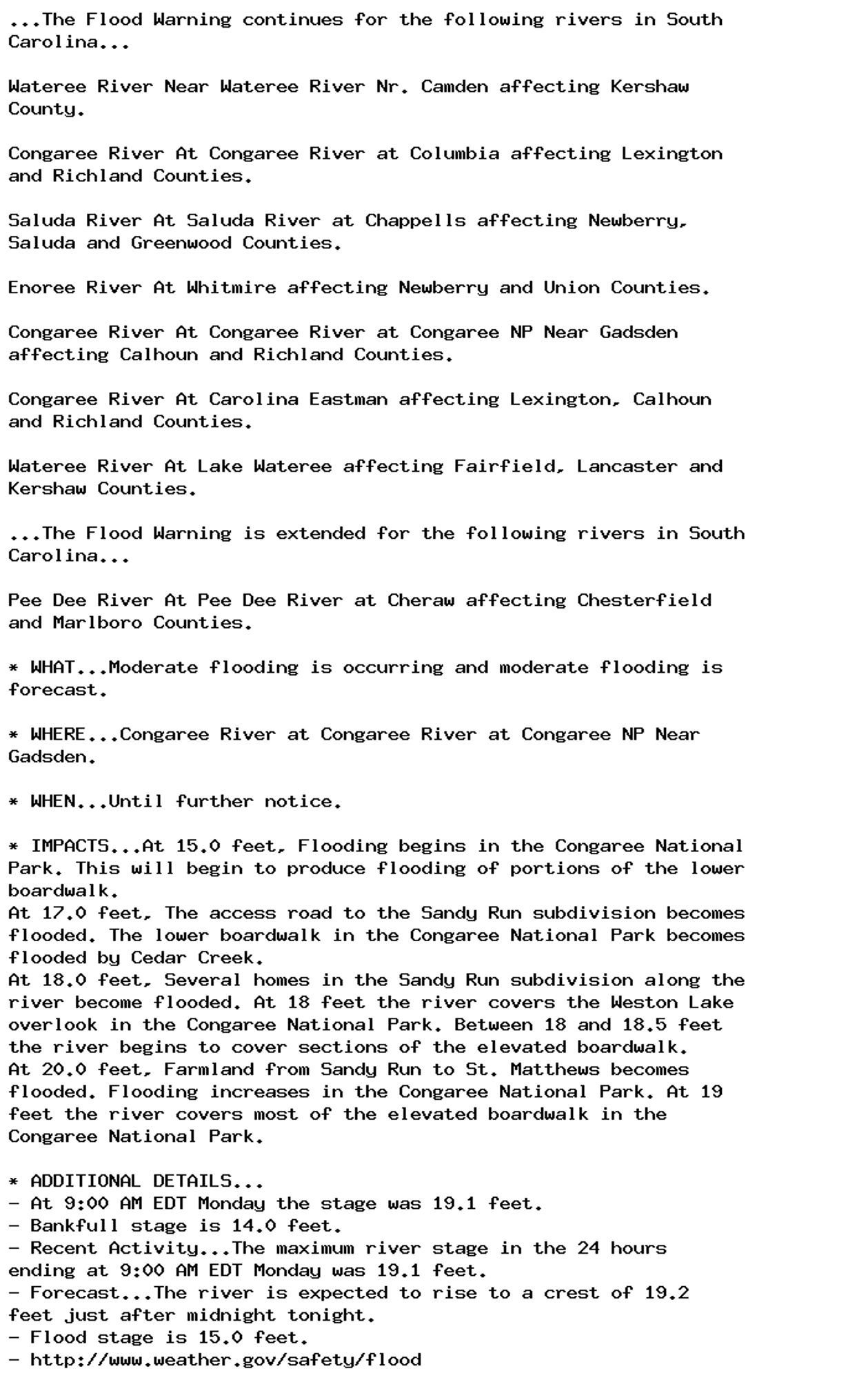
🚨 Flood Warning issued September 30 at 10:30AM EDT until October 2 at 4:05PM EDT by NWS Columbia SC 🚨 Additional Details Here.

...The Flood Warning continues for the following rivers in South
Carolina...

Wateree River Near Wateree River Nr. Camden affecting Kershaw
County.

Congaree River At Congaree River at Columbia affecting Lexington
and Richland Counties.

Saluda River At Saluda River at Chappells affecting Newberry,
Saluda and Greenwood Counties.

Enoree River At Whitmire affecting Newberry and Union Counties.

Congaree River At Congaree River at Congaree NP Near Gadsden
affecting Calhoun and Richland Counties.

Congaree River At Carolina Eastman affecting Lexington, Calhoun
and Richland Counties.

Wateree River At Lake Wateree affecting Fairfield, Lancaster and
Kershaw Counties.

...The Flood Warning is extended for the following rivers in South
Carolina...

Pee Dee River At Pee Dee River at Cheraw affecting Chesterfield
and Marlboro Counties.

* WHAT...Moderate flooding is occurring and moderate flooding is
forecast.

* WHERE...Saluda River at Saluda River at Chappells.

* WHEN...Until Wednesday afternoon.

* IMPACTS...At 14.0 feet, Lowlands around and downstream from
Chappells become flooded. Cattle grazing river bottomland should
be moved to higher ground.
At 16.0 feet, Extensive farmland and river bottomland around and
downstream from Chappells become flooded.
At 18.0 feet, The Saluda River Campground including the Campground
Store downstream from Chappells becomes flooded. Campers should
move to higher ground.
At 21.0 feet, Extensive flooding occurs. Farmland and river
bottomland around and downstream from Chappells become flooded.
Much of the Saluda River Campground downstream from Chappells
become flooded.

* ADDITIONAL DETAILS...
- At 9:15 AM EDT Monday the stage was 22.1 feet.
- Bankfull stage is 14.0 feet.
- Recent Activity...The maximum river stage in the 24 hours
ending at 9:15 AM EDT Monday was 25.5 feet.
- Forecast...The river is expected to fall below flood stage
tomorrow afternoon and continue falling to 7.9 feet Saturday
morning.
- Flood stage is 14.0 feet.
- http://www.weather.gov/safety/flood
0
AFcae.nws-bot.us

🚨 Flood Warning issued September 30 at 10:30AM EDT by NWS Columbia SC 🚨 Additional Details Here.

...The Flood Warning continues for the following rivers in South
Carolina...

Wateree River Near Wateree River Nr. Camden affecting Kershaw
County.

Congaree River At Congaree River at Columbia affecting Lexington
and Richland Counties.

Saluda River At Saluda River at Chappells affecting Newberry,
Saluda and Greenwood Counties.

Enoree River At Whitmire affecting Newberry and Union Counties.

Congaree River At Congaree River at Congaree NP Near Gadsden
affecting Calhoun and Richland Counties.

Congaree River At Carolina Eastman affecting Lexington, Calhoun
and Richland Counties.

Wateree River At Lake Wateree affecting Fairfield, Lancaster and
Kershaw Counties.

...The Flood Warning is extended for the following rivers in South
Carolina...

Pee Dee River At Pee Dee River at Cheraw affecting Chesterfield
and Marlboro Counties.

* WHAT...Moderate flooding is occurring and moderate flooding is
forecast.

* WHERE...Congaree River at Congaree River at Congaree NP Near
Gadsden.

* WHEN...Until further notice.

* IMPACTS...At 15.0 feet, Flooding begins in the Congaree National
Park. This will begin to produce flooding of portions of the lower
boardwalk.
At 17.0 feet, The access road to the Sandy Run subdivision becomes
flooded. The lower boardwalk in the Congaree National Park becomes
flooded by Cedar Creek.
At 18.0 feet, Several homes in the Sandy Run subdivision along the
river become flooded. At 18 feet the river covers the Weston Lake
overlook in the Congaree National Park. Between 18 and 18.5 feet
the river begins to cover sections of the elevated boardwalk.
At 20.0 feet, Farmland from Sandy Run to St. Matthews becomes
flooded. Flooding increases in the Congaree National Park. At 19
feet the river covers most of the elevated boardwalk in the
Congaree National Park.

* ADDITIONAL DETAILS...
- At 9:00 AM EDT Monday the stage was 19.1 feet.
- Bankfull stage is 14.0 feet.
- Recent Activity...The maximum river stage in the 24 hours
ending at 9:00 AM EDT Monday was 19.1 feet.
- Forecast...The river is expected to rise to a crest of 19.2
feet just after midnight tonight.
- Flood stage is 15.0 feet.
- http://www.weather.gov/safety/flood
0
AFcae.nws-bot.us

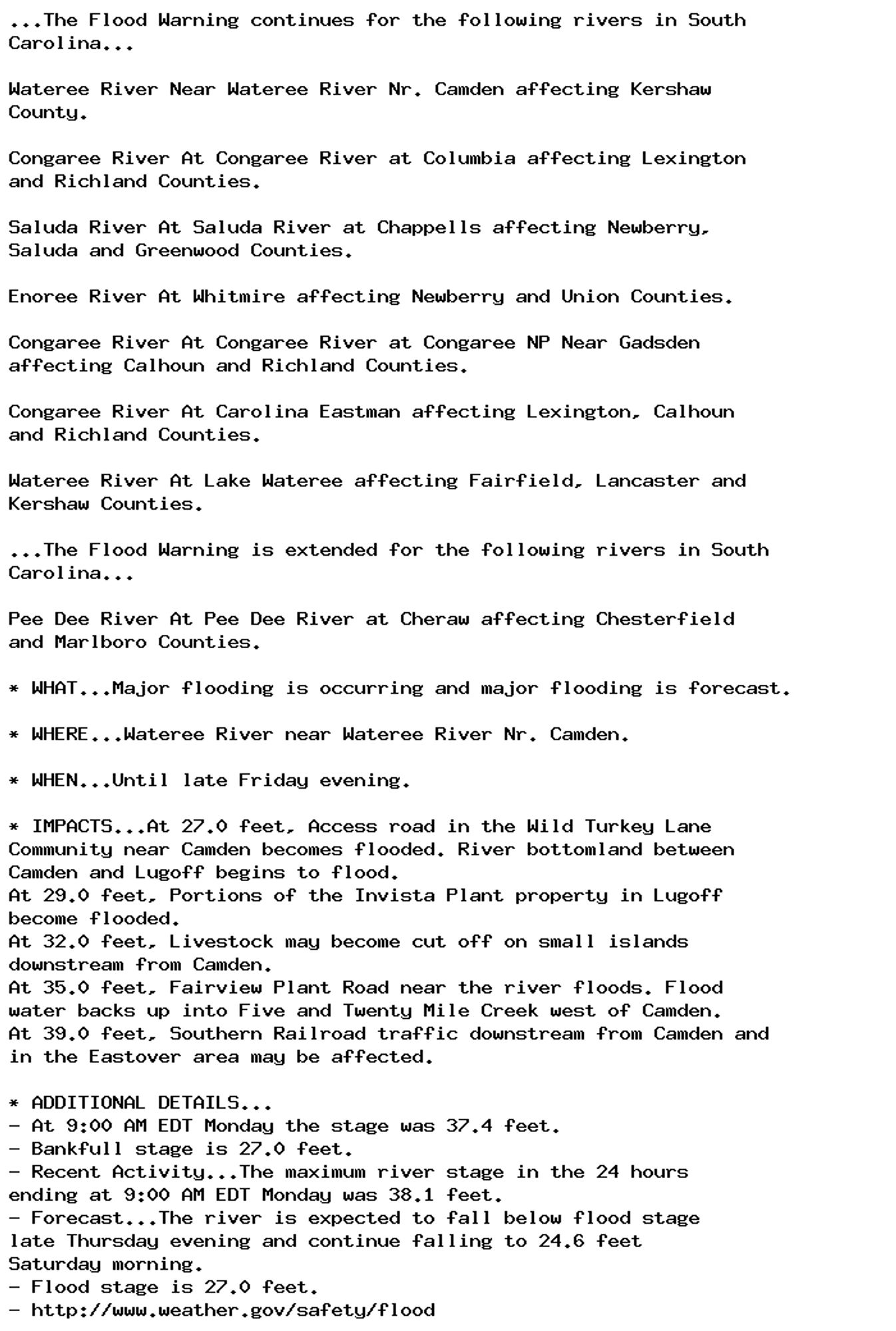
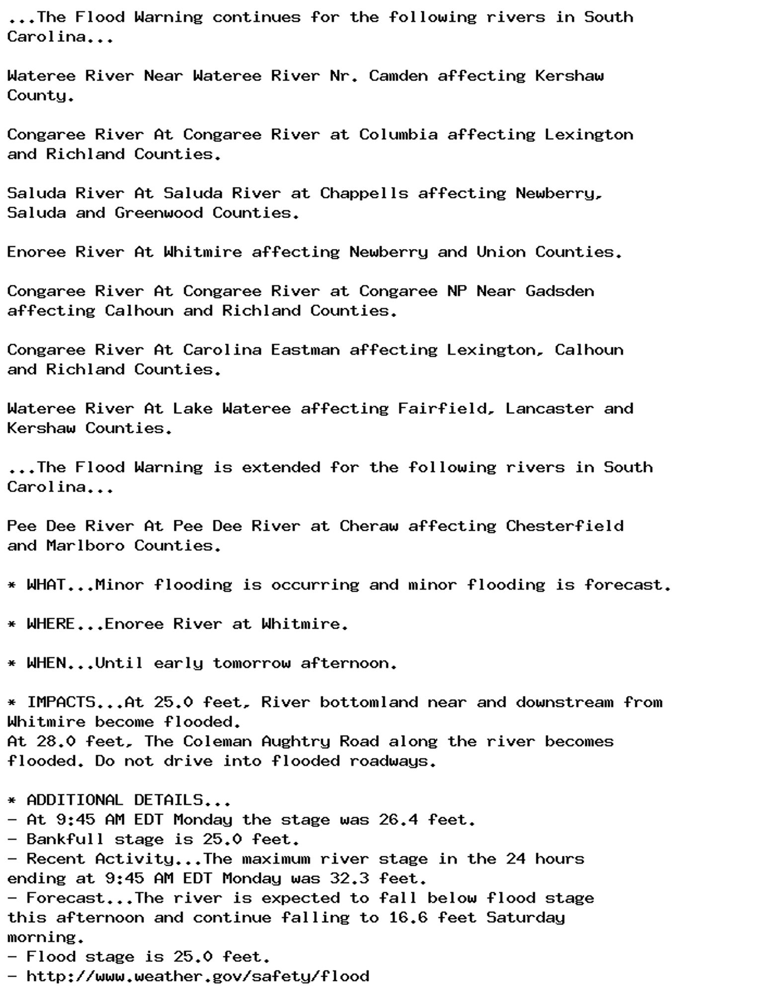
🚨 Flood Warning issued September 30 at 10:30AM EDT until October 1 at 2:51PM EDT by NWS Columbia SC 🚨 Additional Details Here.

...The Flood Warning continues for the following rivers in South
Carolina...

Wateree River Near Wateree River Nr. Camden affecting Kershaw
County.

Congaree River At Congaree River at Columbia affecting Lexington
and Richland Counties.

Saluda River At Saluda River at Chappells affecting Newberry,
Saluda and Greenwood Counties.

Enoree River At Whitmire affecting Newberry and Union Counties.

Congaree River At Congaree River at Congaree NP Near Gadsden
affecting Calhoun and Richland Counties.

Congaree River At Carolina Eastman affecting Lexington, Calhoun
and Richland Counties.

Wateree River At Lake Wateree affecting Fairfield, Lancaster and
Kershaw Counties.

...The Flood Warning is extended for the following rivers in South
Carolina...

Pee Dee River At Pee Dee River at Cheraw affecting Chesterfield
and Marlboro Counties.

* WHAT...Minor flooding is occurring and minor flooding is forecast.

* WHERE...Enoree River at Whitmire.

* WHEN...Until early tomorrow afternoon.

* IMPACTS...At 25.0 feet, River bottomland near and downstream from
Whitmire become flooded.
At 28.0 feet, The Coleman Aughtry Road along the river becomes
flooded. Do not drive into flooded roadways.

* ADDITIONAL DETAILS...
- At 9:45 AM EDT Monday the stage was 26.4 feet.
- Bankfull stage is 25.0 feet.
- Recent Activity...The maximum river stage in the 24 hours
ending at 9:45 AM EDT Monday was 32.3 feet.
- Forecast...The river is expected to fall below flood stage
this afternoon and continue falling to 16.6 feet Saturday
morning.
- Flood stage is 25.0 feet.
- http://www.weather.gov/safety/flood
0
AFcae.nws-bot.us

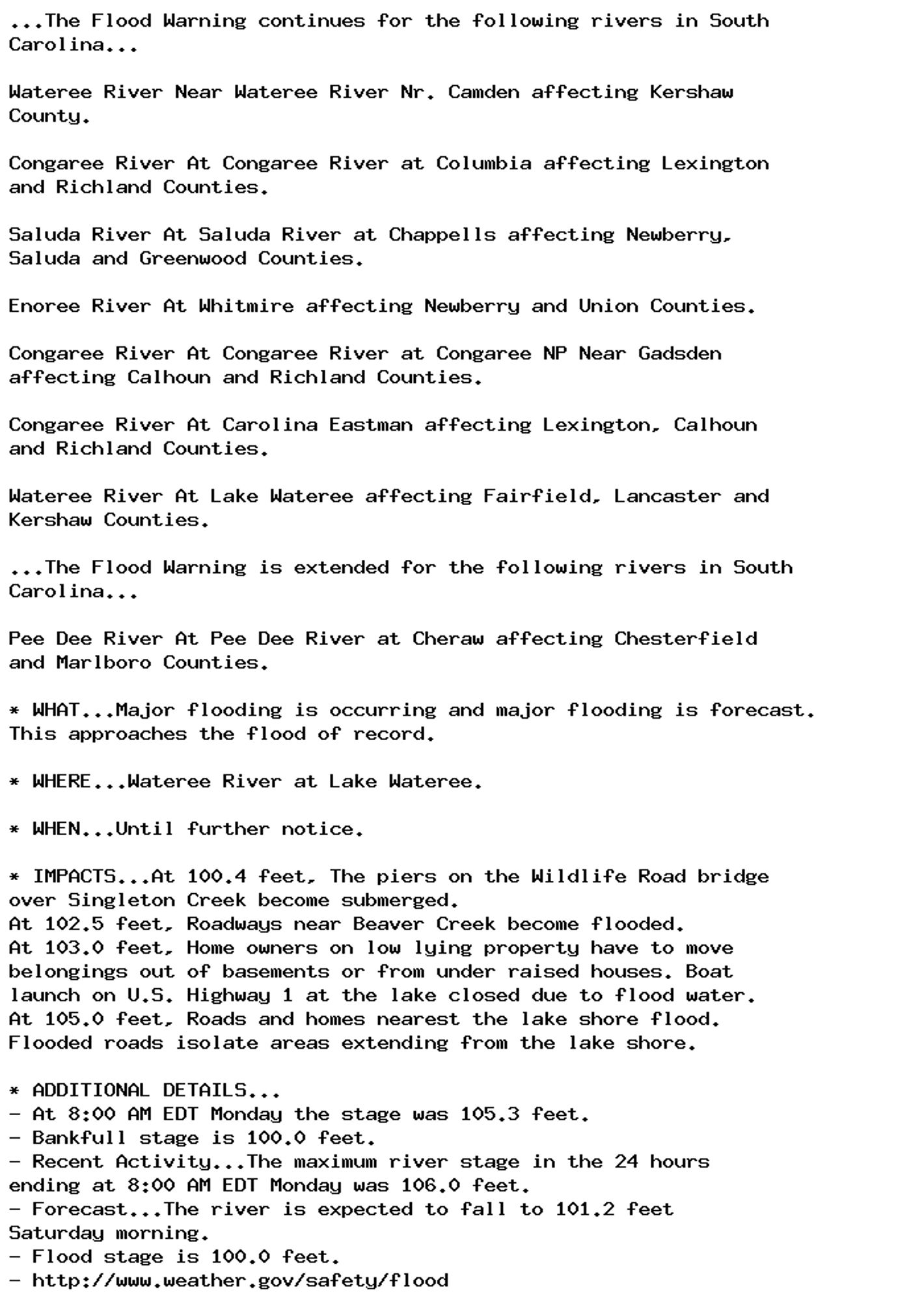
🚨 Flood Warning issued September 30 at 10:30AM EDT until October 3 at 1:22AM EDT by NWS Columbia SC 🚨 Additional Details Here.

...The Flood Warning continues for the following rivers in South
Carolina...

Wateree River Near Wateree River Nr. Camden affecting Kershaw
County.

Congaree River At Congaree River at Columbia affecting Lexington
and Richland Counties.

Saluda River At Saluda River at Chappells affecting Newberry,
Saluda and Greenwood Counties.

Enoree River At Whitmire affecting Newberry and Union Counties.

Congaree River At Congaree River at Congaree NP Near Gadsden
affecting Calhoun and Richland Counties.

Congaree River At Carolina Eastman affecting Lexington, Calhoun
and Richland Counties.

Wateree River At Lake Wateree affecting Fairfield, Lancaster and
Kershaw Counties.

...The Flood Warning is extended for the following rivers in South
Carolina...

Pee Dee River At Pee Dee River at Cheraw affecting Chesterfield
and Marlboro Counties.

* WHAT...Major flooding is occurring and major flooding is forecast.

* WHERE...Congaree River at Congaree River at Columbia.

* WHEN...Until early Thursday morning.

* IMPACTS...At 10.0 feet, Flooding occurs in flood prone areas near
and downstream from Columbia. Flooding also occurs on parts of the
Cayce and West Columbia river walk.
At 13.0 feet, Flooding occurs in flood prone areas near and
downstream from Columbia. Flooding also occurs over much of the
Cayce and West Columbia river walk.
At 14.0 feet, Roads in low lying areas and swampland downstream
from Columbia become flooded. Most of the Cayce and West Columbia
river walk is flooded.
At 16.0 feet, Old State Road, SC 66, below Cayce becomes flooded.
At 19.0 feet, Extensive swampland and large areas of farmland and
pasture land downstream from Columbia become flooded.
At 21.0 feet, Extensive swampland and large areas of farmland and
pasture land downstream from Columbia are flooded.
At 24.0 feet, Flooding also occurs in the Cayce Quarry.
At 28.0 feet, Flooding begins in low lying areas of the Riverland
Park subdivision in Cayce.
At 30.0 feet, The Enclave Apartments along the Broad River and
I-20 become flooded.

* ADDITIONAL DETAILS...
- At 9:00 AM EDT Monday the stage was 30.6 feet.
- Bankfull stage is 19.0 feet.
- Recent Activity...The maximum river stage in the 24 hours
ending at 9:00 AM EDT Monday was 30.6 feet.
- Forecast...The river is expected to rise to a crest of 31.0
feet this afternoon. It will then fall below flood stage
early Wednesday morning.
- Flood stage is 19.0 feet.
- http://www.weather.gov/safety/flood
0
AFcae.nws-bot.us

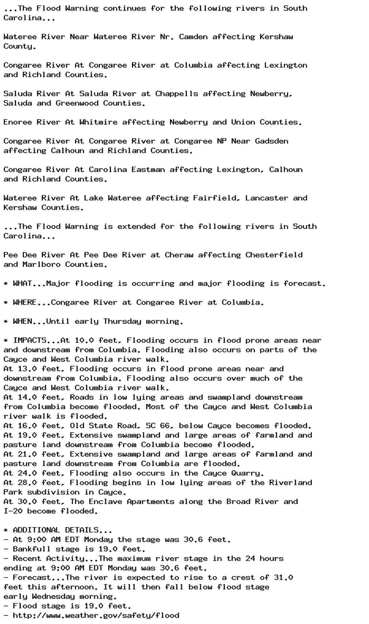
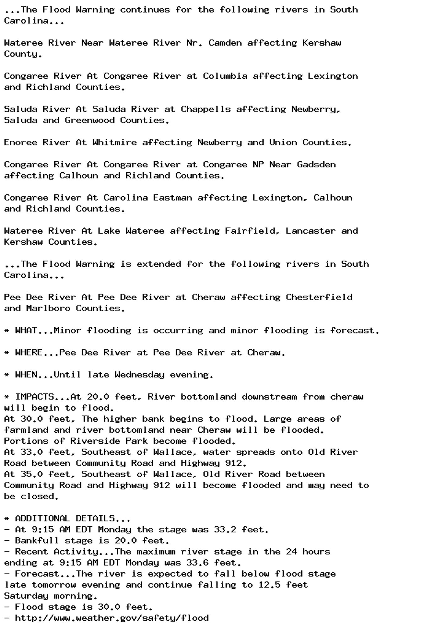
🚨 Flood Warning issued September 30 at 10:30AM EDT until October 4 at 9:12PM EDT by NWS Columbia SC 🚨 Additional Details Here.

...The Flood Warning continues for the following rivers in South
Carolina...

Wateree River Near Wateree River Nr. Camden affecting Kershaw
County.

Congaree River At Congaree River at Columbia affecting Lexington
and Richland Counties.

Saluda River At Saluda River at Chappells affecting Newberry,
Saluda and Greenwood Counties.

Enoree River At Whitmire affecting Newberry and Union Counties.

Congaree River At Congaree River at Congaree NP Near Gadsden
affecting Calhoun and Richland Counties.

Congaree River At Carolina Eastman affecting Lexington, Calhoun
and Richland Counties.

Wateree River At Lake Wateree affecting Fairfield, Lancaster and
Kershaw Counties.

...The Flood Warning is extended for the following rivers in South
Carolina...

Pee Dee River At Pee Dee River at Cheraw affecting Chesterfield
and Marlboro Counties.

* WHAT...Major flooding is occurring and major flooding is forecast.

* WHERE...Wateree River near Wateree River Nr. Camden.

* WHEN...Until late Friday evening.

* IMPACTS...At 27.0 feet, Access road in the Wild Turkey Lane
Community near Camden becomes flooded. River bottomland between
Camden and Lugoff begins to flood.
At 29.0 feet, Portions of the Invista Plant property in Lugoff
become flooded.
At 32.0 feet, Livestock may become cut off on small islands
downstream from Camden.
At 35.0 feet, Fairview Plant Road near the river floods. Flood
water backs up into Five and Twenty Mile Creek west of Camden.
At 39.0 feet, Southern Railroad traffic downstream from Camden and
in the Eastover area may be affected.

* ADDITIONAL DETAILS...
- At 9:00 AM EDT Monday the stage was 37.4 feet.
- Bankfull stage is 27.0 feet.
- Recent Activity...The maximum river stage in the 24 hours
ending at 9:00 AM EDT Monday was 38.1 feet.
- Forecast...The river is expected to fall below flood stage
late Thursday evening and continue falling to 24.6 feet
Saturday morning.
- Flood stage is 27.0 feet.
- http://www.weather.gov/safety/flood
0
AFcae.nws-bot.us

🚨 Flood Warning issued September 30 at 10:30AM EDT by NWS Columbia SC 🚨 Additional Details Here.

...The Flood Warning continues for the following rivers in South
Carolina...

Wateree River Near Wateree River Nr. Camden affecting Kershaw
County.

Congaree River At Congaree River at Columbia affecting Lexington
and Richland Counties.

Saluda River At Saluda River at Chappells affecting Newberry,
Saluda and Greenwood Counties.

Enoree River At Whitmire affecting Newberry and Union Counties.

Congaree River At Congaree River at Congaree NP Near Gadsden
affecting Calhoun and Richland Counties.

Congaree River At Carolina Eastman affecting Lexington, Calhoun
and Richland Counties.

Wateree River At Lake Wateree affecting Fairfield, Lancaster and
Kershaw Counties.

...The Flood Warning is extended for the following rivers in South
Carolina...

Pee Dee River At Pee Dee River at Cheraw affecting Chesterfield
and Marlboro Counties.

* WHAT...Major flooding is occurring and major flooding is forecast.

* WHERE...Congaree River at Carolina Eastman.

* WHEN...Until further notice.

* IMPACTS...At 115.0 feet, Flooding occurs in low lying areas of the
Carolina Eastman Facility and at the Congaree National Park.
At 119.0 feet, Extensive flooding occurs in the Congaree National
Park. Some area farmland is flooded. Minor flooding occurs at the
Carolina Eastman Facility.
At 124.0 feet, Extensive flooding occurs at the Carolina Eastman
Facility with some access roads flooded. Extensive farmland
flooding occurs in the area.
At 126.0 feet, Extensive farmland and lowland flooding will occur
south of Columbia to Lake Marion. Water reaches the top of some
dikes at the Carolina Eastman Facility.
At 127.0 feet, Portions of the Carolina Eastman facility have to
be evacuated.

* ADDITIONAL DETAILS...
- At 8:00 AM EDT Monday the stage was 126.9 feet.
- Bankfull stage is 114.0 feet.
- Recent Activity...The maximum river stage in the 24 hours
ending at 8:00 AM EDT Monday was 126.9 feet.
- Forecast...The river is expected to rise to a crest of 127.0
feet this afternoon.
- Flood stage is 115.0 feet.
- http://www.weather.gov/safety/flood
0
AFcae.nws-bot.us

🚨 Flood Warning issued September 30 at 10:30AM EDT by NWS Columbia SC 🚨 Additional Details Here.

...The Flood Warning continues for the following rivers in South
Carolina...

Wateree River Near Wateree River Nr. Camden affecting Kershaw
County.

Congaree River At Congaree River at Columbia affecting Lexington
and Richland Counties.

Saluda River At Saluda River at Chappells affecting Newberry,
Saluda and Greenwood Counties.

Enoree River At Whitmire affecting Newberry and Union Counties.

Congaree River At Congaree River at Congaree NP Near Gadsden
affecting Calhoun and Richland Counties.

Congaree River At Carolina Eastman affecting Lexington, Calhoun
and Richland Counties.

Wateree River At Lake Wateree affecting Fairfield, Lancaster and
Kershaw Counties.

...The Flood Warning is extended for the following rivers in South
Carolina...

Pee Dee River At Pee Dee River at Cheraw affecting Chesterfield
and Marlboro Counties.

* WHAT...Major flooding is occurring and major flooding is forecast.
This approaches the flood of record.

* WHERE...Wateree River at Lake Wateree.

* WHEN...Until further notice.

* IMPACTS...At 100.4 feet, The piers on the Wildlife Road bridge
over Singleton Creek become submerged.
At 102.5 feet, Roadways near Beaver Creek become flooded.
At 103.0 feet, Home owners on low lying property have to move
belongings out of basements or from under raised houses. Boat
launch on U.S. Highway 1 at the lake closed due to flood water.
At 105.0 feet, Roads and homes nearest the lake shore flood.
Flooded roads isolate areas extending from the lake shore.

* ADDITIONAL DETAILS...
- At 8:00 AM EDT Monday the stage was 105.3 feet.
- Bankfull stage is 100.0 feet.
- Recent Activity...The maximum river stage in the 24 hours
ending at 8:00 AM EDT Monday was 106.0 feet.
- Forecast...The river is expected to fall to 101.2 feet
Saturday morning.
- Flood stage is 100.0 feet.
- http://www.weather.gov/safety/flood
0