BLUE
MAmbta-alerts.bsky.social

Route 132 detour: Route 132 detoured from Mon Sep 30 through Tue Oct 1 due to construction. The nearest outbound connections Malden Center and Washington St @ Oak Grove St. The nearest inbound connections are Washington St @ Grove St and Malden Center. Updated: 2024-10-02 00:00:17 (Eastern).

0
marketbot.tm2t.net

UNIVA・OAKホールディン(3113) 東証S 始値81円 高値82円 安値81円 終値82円 前日比+1円(+1.23%) VWAP81.0802円 出来高13,700株 前日比16,100株減(-54.03%) O/U比率-73.14% OVER 132800株 UNDER 20600株 [2024/10/02 11:26]

0
CNcarlnyberg312.bsky.social

Because my father disliked/distrusted television, we had some quality slide and movie systems, including 8 mm. We could get silent movies from Oak Park Public Library. So, I saw more Chaplin than most people born after 1927.

0
AFdlh.nws-bot.us

Small Craft Advisory issued October 1 at 8:55PM CDT until October 2 at 7:00AM CDT by NWS Duluth MN Additional Details Here.

* WHAT...For the Small Craft Advisory, southwest winds 15 to 25 kt
with gusts up to 30 kt and waves 1 to 4 ft expected. For the
Gale Warning, southwest winds 15 to 25 kt with gusts up to 40 kt
and waves 3 to 6 ft expected.

* WHERE...Chequamegon Bay-Bayfield to Oak Point WI, Port Wing to
Sand Island WI, Sand Island to Bayfield WI, Oak Point to Saxon
Harbor WI and Outer Apostle Islands Beyond 5 NM from Mainland.

* WHEN...For the Small Craft Advisory, from 1 AM to 7 AM CDT
Wednesday. For the Gale Warning, from 7 AM to 4 PM CDT
Wednesday.

* IMPACTS...Strong winds will cause hazardous waves which could
capsize or damage vessels and reduce visibility.
0
AFdlh.nws-bot.us

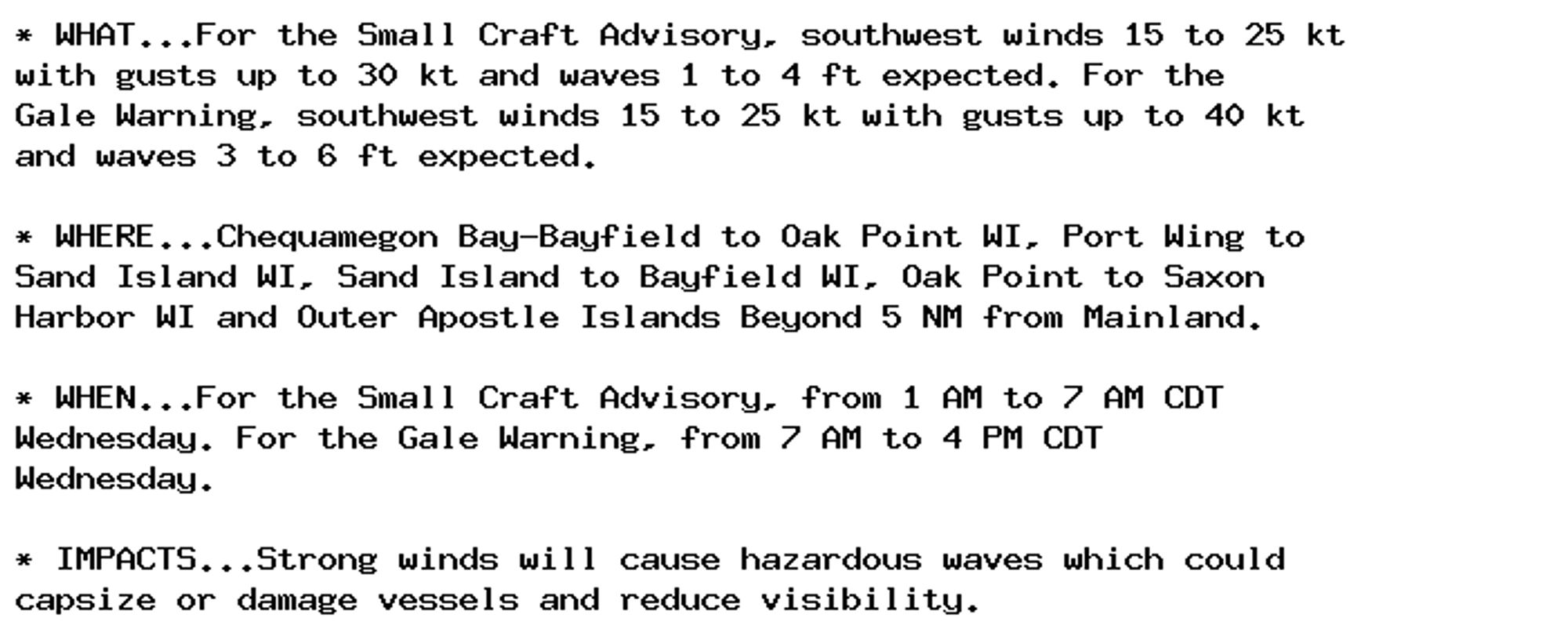
Gale Warning issued October 1 at 8:55PM CDT until October 2 at 4:00PM CDT by NWS Duluth MN Additional Details Here.

* WHAT...For the Small Craft Advisory, southwest winds 15 to 25 kt
with gusts up to 30 kt and waves 1 to 4 ft expected. For the
Gale Warning, southwest winds 15 to 25 kt with gusts up to 40 kt
and waves 3 to 6 ft expected.

* WHERE...Chequamegon Bay-Bayfield to Oak Point WI, Port Wing to
Sand Island WI, Sand Island to Bayfield WI, Oak Point to Saxon
Harbor WI and Outer Apostle Islands Beyond 5 NM from Mainland.

* WHEN...For the Small Craft Advisory, from 1 AM to 7 AM CDT
Wednesday. For the Gale Warning, from 7 AM to 4 PM CDT
Wednesday.

* IMPACTS...Strong winds will cause hazardous waves which could
capsize or damage vessels and reduce visibility.
0
AFilm.nws-bot.us

🚨 Flood Warning issued October 1 at 9:58PM EDT by NWS Wilmington NC 🚨 Additional Details Here.

...The Flood Warning is extended for the following rivers in North
Carolina...

Cape Fear River At William O Huske Lock And Dam 3 affecting
Bladen and Cumberland Counties.

...The Flood Warning continues for the following rivers in South
Carolina...

Waccamaw River At Conway affecting Horry County.

Great Pee Dee River At Pee Dee affecting Marion and Florence
Counties.

* WHAT...Minor flooding is occurring and minor flooding is forecast.

* WHERE...Waccamaw River at Conway.

* WHEN...Until further notice.

* IMPACTS...At 12.0 feet, Flooding will worsen in Lees Landing,
Riverfront South, Pitch Landing, and Savannah Bluff. Flooding will
also worsen along Waccamaw CIR, Riverside DR, and in low areas
along Gray Oak DR. Flood waters will begin to affect Black Moss DR
and Cypress Flat. Depot RD, New RD, and Jackson Bluff RD may begin
to flood.  The lowest homes on Riverside DR north of Conway may be
affected.  Witch Golf Course may begin to flood. Swamps will be
heavily flooded.

* ADDITIONAL DETAILS...
- At 9:15 PM EDT Tuesday the stage was 11.5 feet.
- Forecast...The river is expected to rise to a crest of 11.6
feet tomorrow morning.
- Flood stage is 11.0 feet.
- http://www.weather.gov/safety/flood
0
Ryoufoundryan.bsky.social

that's my goal! my backyard is even bigger and has a huge tree of heaven problem but eventually i'm gonna turn a big chunk of it into a native oak grove with gooseberries, mountain mahogany, elderberry, alliums, lupines, yarrow and bee balm

1

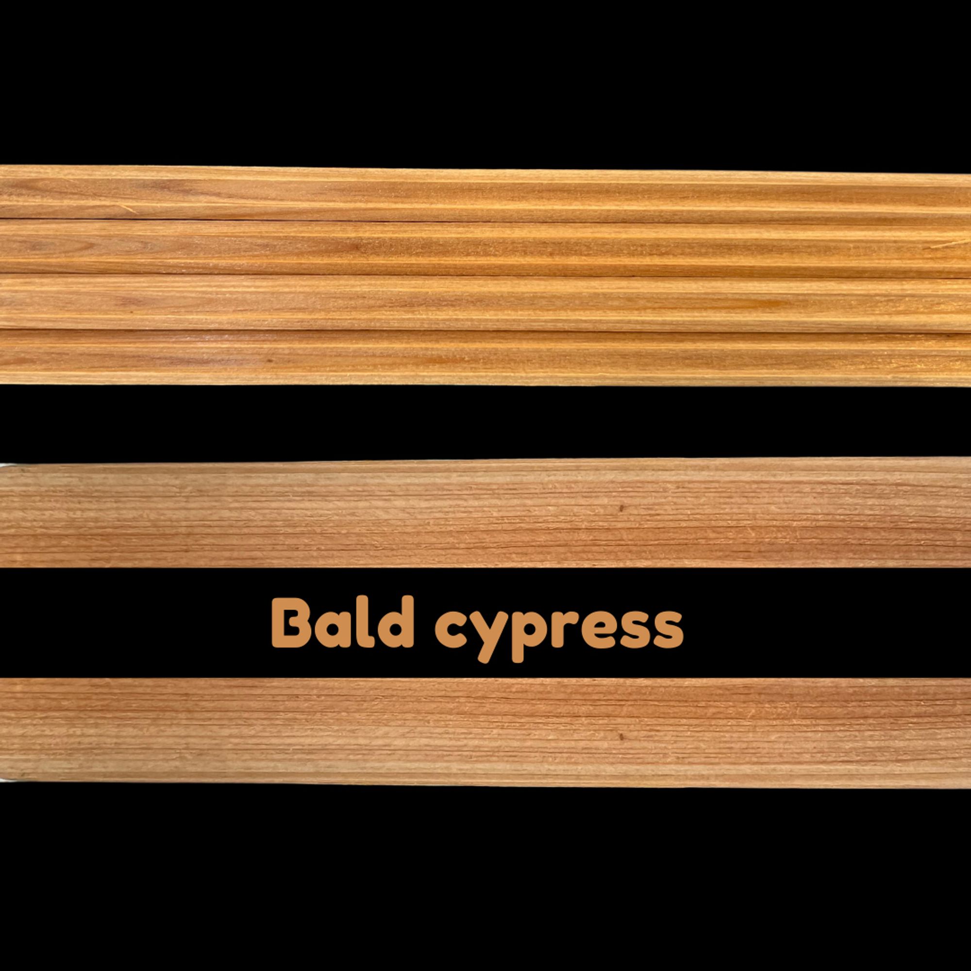
📣 Announcing New Core Mount Additions!! Bald cypress, oak, pine, & more coming soon! All 🌲💍s are special, but some deserve to be shown off a little more. Soon you can display them in style ✨Pricing/availability coming soon to dendrosupply.com#dendro#dendrochronology

0