BLUE
DEemlynkd.bsky.social

There is alot of research being done recently on this & related topics, including theorising possible Black Sea or even riverine transmission routes. Some particularly interesting - often competing - data coming from ancient DNA & archaeobotanical work looking at early domestication trends

1
JGjustingundlach.bsky.social

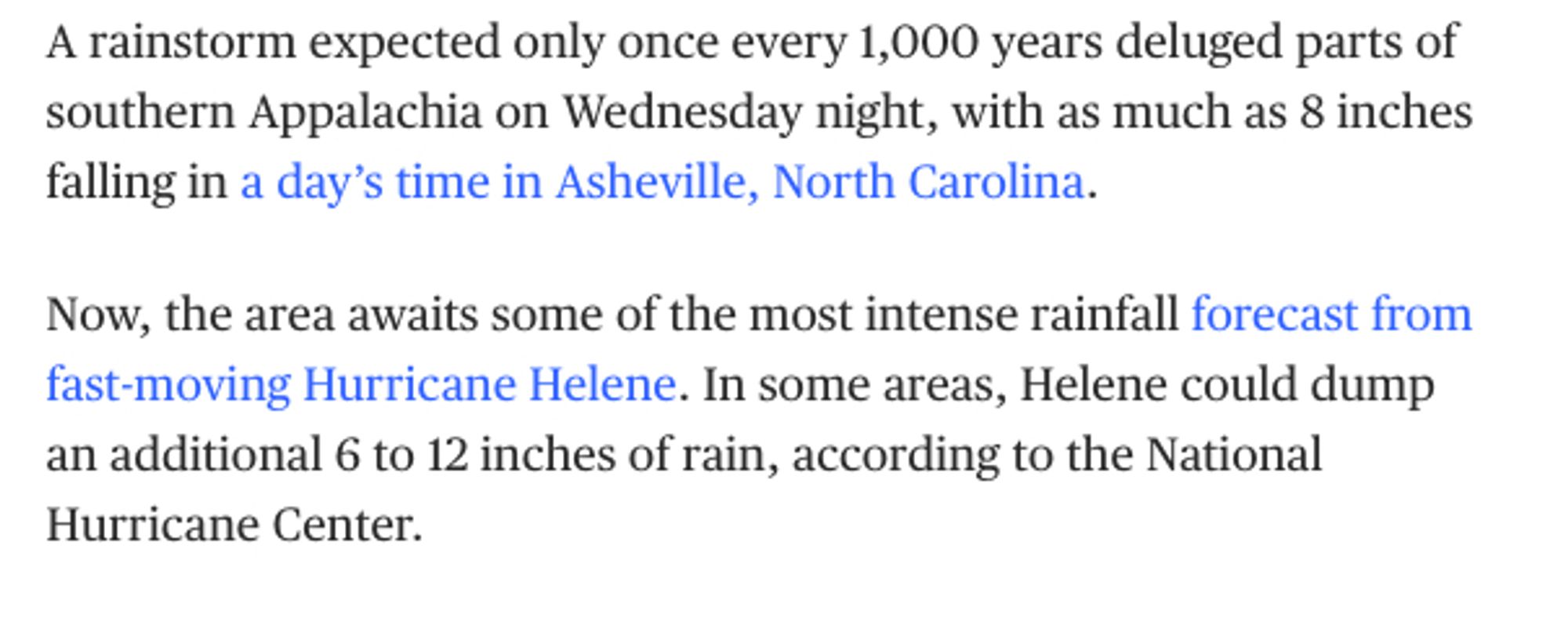
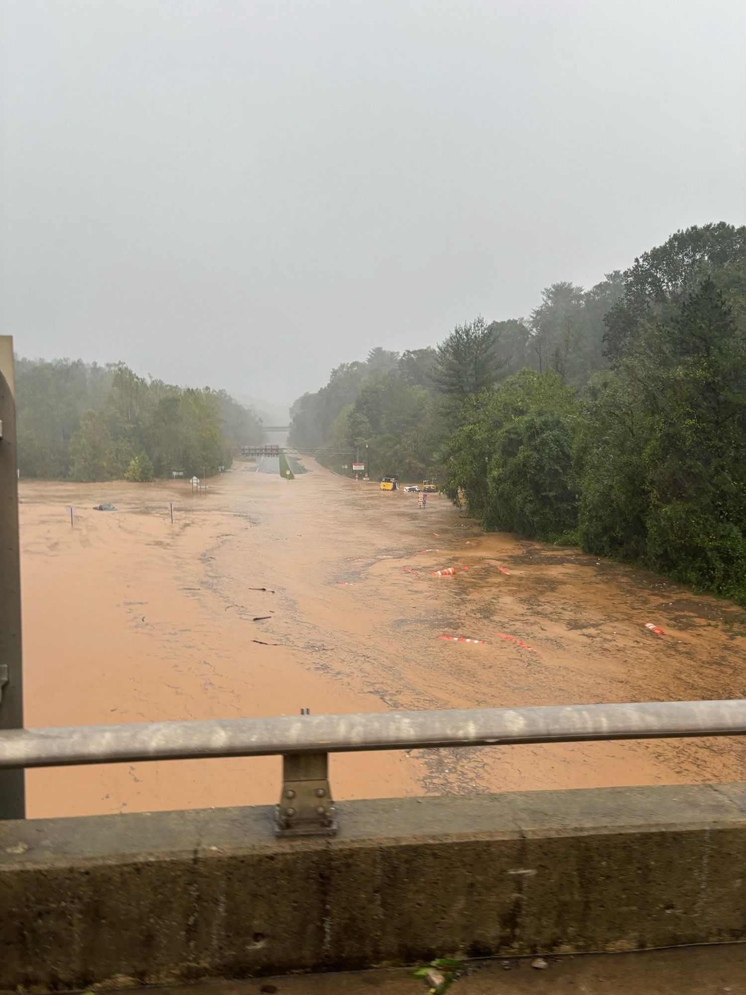
I was also thinking of places like Asheville and others where bogus, low-budget "hey look at this climate-safe location for which we have not scrutinized susceptibility to riverine flooding" recommendations have confused and misled people. Not just Florida.

1
ADallidejong.bsky.social

even floodplains as the NFIP defines them are pretty limited! i have talked about this before but FEMA’s approach only incorporates coastal surge and riverine flood risk. so not, for example, cloudburst precip overflowing a drainage system

1
LVlvulis.bsky.social

TBF parts are high risk, doesn't detract from original point. hazards.fema.gov/nri/riverine...

0
KHkellyhereid.bsky.social

Love this whole thread and discussion. If multiple event mechanisms (such as thunderstorm + hurricane) aren't treated adequately in return period estimates, you'll get crazy numbers, and maybe underestimate the real risk. See also: coastal flood from riverine + storm surge combos.

0
AFtlh.nws-bot.us

Tropical Cyclone Statement issued September 27 at 11:45AM EDT by NWS Tallahassee FL Additional Details Here.

HLSTAE

This product covers eastern Florida panhandle, Florida Big Bend, southeastern Alabama and southwestern Georgia
**TROPICAL STORM HELENE CONTINUES TO MOVE FURTHER AWAY. RESIDUAL
COASTAL FLOODING AND OTHER BEACH HAZARDS COTINUE. **

NEW INFORMATION
---------------

* CHANGES TO WATCHES AND WARNINGS:
- All watches and warnings have been canceled

* CURRENT WATCHES AND WARNINGS:
- None

* STORM INFORMATION:
- About 360 miles north-northeast of Panama City or about 380
miles north of Apalachicola
- 35.1N 83.8W
- Storm Intensity 45 mph
- Movement North or 350 degrees at 32 mph

SITUATION OVERVIEW
------------------

At 11 AM EDT, the center of Tropical Storm Helene was located about
100 miles northeast. It is now moving to the north/north- northwest at
32 mph. Conditions have improved this morning as Helene as moved out.
While tropical storm force winds are now out of our of the region,
breezy conditions still will stick around through the rest of the
morning and into early afternoon. Additionally, tides still are
running high and minor coastal flooding could stick around across the
Florida Panhandle and the northeast and eastern portions of the
Apalachee Bay through this afternoon and early evening.

Rainfall from Helene has ended, and new flash flooding is not
expected. Ongoing flooding may take awhile to subside. Minor to
moderate riverine flooding will emerge and continue for days to come.
Please do not drive through flooded roadways and stay out of flood
waters if at all possible. Flood waters may contain downed power
lines, dangerous wildlife, and other hazards.

The tornado threat has passed.

With widespread power outages across the region, please exercise
caution with cleanup efforts and use generators responsibly. Carbon
monoxide poisoning and/or death can result from generator misuse.
Please do not return to evacuated areas until cleared by local
officials to do so. First responders are working as hard as they can
to respond and restore services quickly and safely, and returning too
early may hinder their efforts.

POTENTIAL IMPACTS
-----------------

* OTHER COASTAL HAZARDS:

Minor coastal flooding will be continue along much of the coast today.
Large waves will be possible along the coast this afternoon.
Dangerouns rip currents are expected through at least Saturday.

PRECAUTIONARY/PREPAREDNESS ACTIONS
----------------------------------

* EVACUATIONS:
Follow the advice of local officials


* OTHER PREPAREDNESS INFORMATION:

If your home or shelter was damaged, be alert to the smell of gas
leaks and be cautious around electrical wiring, broken glass, jagged
metal and wood, and protruding nails and screws.

Do not attempt to return to evacuated areas until local authorities
have inspected roads and bridges and have given the all clear.
Hazards like downed power lines and trees, washed out roads,
continued flooding in low lying areas and non-functioning traffic
lights make travel difficult.

Do not go sightseeing within impacted communities. Sightseers
interfere with the emergency work of first responders.

When clearing out fallen trees, be careful with chainsaws and axes.
Always wear protective gear and keep others at a safe distance.
Leaning trees and those which have fallen on roofs or power lines can
be especially dangerous. If you are not in good health or unsure
about what you are doing, have someone with tree cutting experience
do the job. Never cut trees without a partner.

If using a generator, avoid carbon monoxide poisoning by following
instructions provided by the manufacturer. Operate your generator in
a well-ventilated space outside of your living area and away from
open doors and windows.


* ADDITIONAL SOURCES OF INFORMATION:
- For information on appropriate preparations see ready.gov
- For additional disaster preparedness information see redcross.org

NEXT UPDATE
-----------

As it pertains to this event...this will be the last local statement
issued by the National Weather Service in Tallahassee FL regarding
the effects of tropical cyclone hazards upon the area.
0
HCbriar-rose.bsky.social

Caveat: "not in a floodplain" may not be safe from riverine flooding, depending on the quality of flood model used and the amt of water incoming, if way past expected (>1 in 100 chance.) Flash floods & riverine floods can overlap too. But riverine floods may also happen far downstream from a storm.

0
HCbriar-rose.bsky.social

Folks don't realize flash flooding means runoff builds up all over. It can't be absorbed in time. "I'm not in a floodplain" does not make you safe- that's only riverine flooding (river too full). Instead ask, "Am I at the bottom of a potential funnel?" And with an insane amount of rain, that's BAD.

2
AFtlh.nws-bot.us

Tropical Cyclone Statement issued September 27 at 5:34AM EDT by NWS Tallahassee FL Additional Details Here.

HLSTAE

This product covers eastern Florida panhandle, Florida Big Bend, southeastern Alabama and southwestern Georgia

**TROPICAL STORM HELENE MOVING AWAY THROUGH EAST-CENTRAL GEORGIA.
RESIDUAL STORM SURGE CONTINUES AROUND APALACHEE BAY.**

NEW INFORMATION
---------------

* CHANGES TO WATCHES AND WARNINGS:
- The Storm Surge Warning and Hurricane Warning have been
cancelled for Coastal Gulf
- A Tropical Storm Warning has been issued and the Hurricane
Warning has been cancelled for Baker, Ben Hill, Berrien,
Brooks, Coastal Dixie, Coastal Franklin, Coastal Jefferson,
Coastal Taylor, Coastal Wakulla, Colquitt, Cook, Dougherty,
Inland Dixie, Inland Taylor, Irwin, Lafayette, Lanier, Lee,
Lowndes, Madison, Mitchell, Terrell, Thomas, Tift, Turner, and
Worth
- The Hurricane Warning has been cancelled for Calhoun, Clay,
Decatur, Early, Gadsden, Grady, Inland Franklin, Inland Gulf,
Inland Jefferson, Inland Wakulla, Leon, Liberty, Miller,
Quitman, Randolph, and Seminole
- The Tropical Storm Warning has been cancelled for Calhoun,
Central Walton, Coastal Bay, Coffee, Dale, Geneva, Henry,
Holmes, Houston, Inland Bay, Jackson, North Walton, South
Walton, and Washington

* CURRENT WATCHES AND WARNINGS:
- A Storm Surge Warning and Tropical Storm Warning are in effect
for Coastal Dixie, Coastal Franklin, Coastal Jefferson, Coastal
Taylor, Coastal Wakulla, Inland Dixie, and Inland Taylor
- A Storm Surge Warning is in effect for Inland Jefferson and
Inland Wakulla
- A Tropical Storm Warning is in effect for Baker, Ben Hill,
Berrien, Brooks, Colquitt, Cook, Dougherty, Irwin, Lafayette,
Lanier, Lee, Lowndes, Madison, Mitchell, Terrell, Thomas, Tift,
Turner, and Worth

* STORM INFORMATION:
- About 140 miles north of Valdosta
- 32.8N 83.0W
- Storm Intensity 70 mph
- Movement North or 360 degrees at 30 mph

SITUATION OVERVIEW
------------------

At 5 AM EDT, the center of Tropical Storm Helene was located 140 miles
north of Valdosta. It was quickly moving to the north at 30 mph. As
Helene quickly exits our region, conditions will gradually improve
through this morning and afternoon.

Tropical storm force winds will continue for a few more hours this
morning over parts of South Georgia and the eastern Big Bend of
Florida.

Despite the decreasing winds, tides continue to run very high around
Apalachee Bay. At 5 AM EDT, major flooding was still being observed
along the coasts of Taylor and Dixie Counties. Moderate flooding was
observed along the coasts of Franklin, Wakulla, and Jefferson Counties.
It will take until tonight for tides around Apalachee Bay to come out
of flood.

Further west, minor flooding was occurring along coastal Bay
and Gulf Counties, and this will improve late this morning.

New flash flooding is not expected. Minor to moderate riverine flooding
will emerge and continue for days to come.

The tornado threat has passed.


POTENTIAL IMPACTS
-----------------

* SURGE:
Potential impacts from the main surge event are now unfolding along the
shore of Apalachee Bay. Remain well away from life-threatening surge
having additional devastating impacts. If realized, these impacts
include:
- Widespread deep inundation, with storm surge flooding greatly
accentuated by powerful battering waves. Structural damage to
buildings, with many washing away. Damage greatly compounded
from considerable floating debris. Locations may be
uninhabitable for an extended period.
- Near-shore escape routes and secondary roads washed out or
severely flooded. Flood control systems and barriers may become
stressed.
- Extreme beach erosion. New shoreline cuts possible.
- Massive damage to marinas, docks, boardwalks, and piers.
Numerous small craft broken away from moorings with many lifted
onshore and stranded.

Elsewhere across eastern Florida panhandle, Florida Big Bend,
southeastern Alabama and southwestern Georgia, little to no impact is
anticipated.

* WIND:
Potential impacts from the main wind event are now unfolding across
South Georgia and the eastern Big Bend of Florida. Remain well
sheltered from dangerous wind having possible additional significant
impacts. If realized, these impacts include:
- Some damage to roofing and siding materials, along with damage
to porches, awnings, carports, and sheds. A few buildings
experiencing window, door, and garage door failures. Mobile
homes damaged, especially if unanchored. Unsecured lightweight
objects become dangerous projectiles.
- Several large trees snapped or uprooted, but with greater
numbers in places where trees are shallow rooted. Several
fences and roadway signs blown over.
- Some roads impassable from large debris, and more within urban
or heavily wooded places. A few bridges, causeways, and access
routes impassable.
- Scattered power and communications outages, but more prevalent
in areas with above ground lines.

Elsewhere across eastern Florida panhandle, Florida Big Bend,
southeastern Alabama and southwestern Georgia, little to no impact is
anticipated.

PRECAUTIONARY/PREPAREDNESS ACTIONS
----------------------------------

* EVACUATIONS:
Follow the advice of local officials.

* OTHER PREPAREDNESS INFORMATION:

Keep your cell phone charged and in power-saving mode. If you lose
power, use it sparingly and mainly for personal emergencies and
check-ins.

Do not be a thrill seeker or risk your life for senseless photos or
videos.

If you are prone to flooding or in an area under a storm surge watch
or warning, be prepared for the possibility of a quick and dramatic
rise in water levels.

* ADDITIONAL SOURCES OF INFORMATION:
- For information on appropriate preparations see ready.gov
- For additional disaster preparedness information see redcross.org

NEXT UPDATE
-----------

The next local statement will be issued by the National Weather
Service in Tallahassee FL around 12 Noon EDT, or sooner if conditions
warrant.
0