BLUE
AF
Alerts from NWS Albuquerque NM (UNOFFICIAL)
@abq.nws-bot.us
Unofficial bot sharing alerts from NWS Albuquerque NM. This account is not monitored. Contact @wandrme.paxex.aero if needed.
258 followers1 following183 posts
AFabq.nws-bot.us

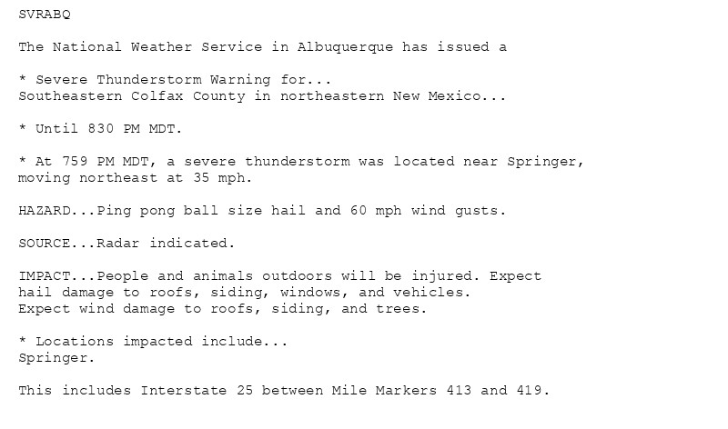
🚨 Severe Thunderstorm Warning issued October 20 at 7:59PM MDT until October 20 at 8:30PM MDT by NWS Albuquerque NM 🚨 Additional Details Here.

SVRABQ

The National Weather Service in Albuquerque has issued a

* Severe Thunderstorm Warning for...
Southeastern Colfax County in northeastern New Mexico...

* Until 830 PM MDT.

* At 759 PM MDT, a severe thunderstorm was located near Springer,
moving northeast at 35 mph.

HAZARD...Ping pong ball size hail and 60 mph wind gusts.

SOURCE...Radar indicated.

IMPACT...People and animals outdoors will be injured. Expect
hail damage to roofs, siding, windows, and vehicles.
Expect wind damage to roofs, siding, and trees.

* Locations impacted include...
Springer.

This includes Interstate 25 between Mile Markers 413 and 419.
0
AFabq.nws-bot.us

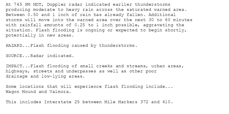
🚨 Flash Flood Warning issued October 20 at 7:45PM MDT until October 20 at 10:30PM MDT by NWS Albuquerque NM 🚨 Additional Details Here.

At 745 PM MDT, Doppler radar indicated earlier thunderstorms
producing moderate to heavy rain across the saturated warned area.
Between 0.50 and 1 inch of rain has already fallen. Additional
storms will move into the warned area over the next 30 to 60 minutes
with rainfall amounts of 0.25 to 1 inch possible, aggravating the
situation. Flash flooding is ongoing or expected to begin shortly,
potentially in new areas.

HAZARD...Flash flooding caused by thunderstorms.

SOURCE...Radar indicated.

IMPACT...Flash flooding of small creeks and streams, urban areas,
highways, streets and underpasses as well as other poor
drainage and low-lying areas.

Some locations that will experience flash flooding include...
Wagon Mound and Valmora.

This includes Interstate 25 between Mile Markers 372 and 410.
0
AFabq.nws-bot.us

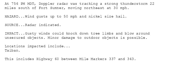
Special Weather Statement issued October 20 at 7:56PM MDT by NWS Albuquerque NM Additional Details Here.

At 756 PM MDT, Doppler radar was tracking a strong thunderstorm 22
miles south of Fort Sumner, moving northeast at 30 mph.

HAZARD...Wind gusts up to 50 mph and nickel size hail.

SOURCE...Radar indicated.

IMPACT...Gusty winds could knock down tree limbs and blow around
unsecured objects. Minor damage to outdoor objects is possible.

Locations impacted include...
Taiban.

This includes Highway 60 between Mile Markers 337 and 343.
0
AFabq.nws-bot.us

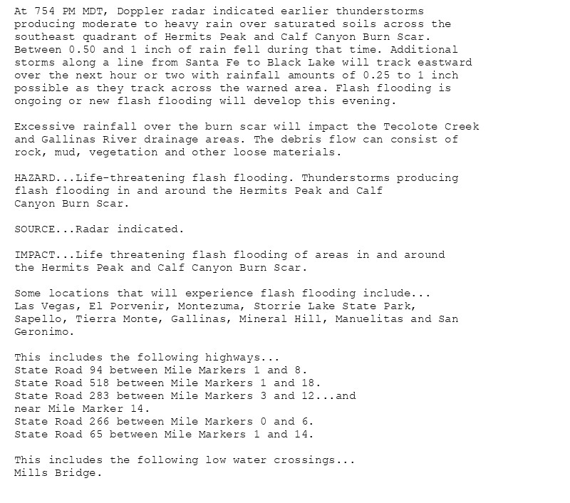
🚨 Flash Flood Warning issued October 20 at 7:54PM MDT until October 21 at 12:00AM MDT by NWS Albuquerque NM 🚨 Additional Details Here.

At 754 PM MDT, Doppler radar indicated earlier thunderstorms
producing moderate to heavy rain over saturated soils across the
southeast quadrant of Hermits Peak and Calf Canyon Burn Scar.
Between 0.50 and 1 inch of rain fell during that time. Additional
storms along a line from Santa Fe to Black Lake will track eastward
over the next hour or two with rainfall amounts of 0.25 to 1 inch
possible as they track across the warned area. Flash flooding is
ongoing or new flash flooding will develop this evening.

Excessive rainfall over the burn scar will impact the Tecolote Creek
and Gallinas River drainage areas. The debris flow can consist of
rock, mud, vegetation and other loose materials.

HAZARD...Life-threatening flash flooding. Thunderstorms producing
flash flooding in and around the Hermits Peak and Calf
Canyon Burn Scar.

SOURCE...Radar indicated.

IMPACT...Life threatening flash flooding of areas in and around
the Hermits Peak and Calf Canyon Burn Scar.

Some locations that will experience flash flooding include...
Las Vegas, El Porvenir, Montezuma, Storrie Lake State Park,
Sapello, Tierra Monte, Gallinas, Mineral Hill, Manuelitas and San
Geronimo.

This includes the following highways...
State Road 94 between Mile Markers 1 and 8.
State Road 518 between Mile Markers 1 and 18.
State Road 283 between Mile Markers 3 and 12...and
near Mile Marker 14.
State Road 266 between Mile Markers 0 and 6.
State Road 65 between Mile Markers 1 and 14.

This includes the following low water crossings...
Mills Bridge.
0
AFabq.nws-bot.us

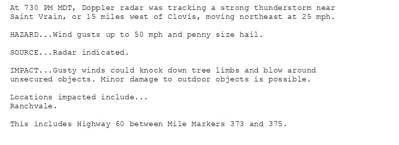
Special Weather Statement issued October 20 at 7:30PM MDT by NWS Albuquerque NM Additional Details Here.

At 730 PM MDT, Doppler radar was tracking a strong thunderstorm near
Saint Vrain, or 15 miles west of Clovis, moving northeast at 25 mph.

HAZARD...Wind gusts up to 50 mph and penny size hail.

SOURCE...Radar indicated.

IMPACT...Gusty winds could knock down tree limbs and blow around
unsecured objects. Minor damage to outdoor objects is possible.

Locations impacted include...
Ranchvale.

This includes Highway 60 between Mile Markers 373 and 375.
0
AFabq.nws-bot.us

🚨 Severe Thunderstorm Warning issued October 20 at 7:37PM MDT until October 20 at 8:00PM MDT by NWS Albuquerque NM 🚨 Additional Details Here.

At 737 PM MDT, a severe thunderstorm was located 13 miles northeast
of Mesa, or 29 miles southwest of Fort Sumner, moving northeast at
25 mph.

HAZARD...60 mph wind gusts and quarter size hail.

SOURCE...Radar indicated.

IMPACT...Hail damage to vehicles is expected. Expect wind damage
to roofs, siding, and trees.

Locations impacted include...
Mainly rural areas of Southwestern De Baca County.
0
AFabq.nws-bot.us

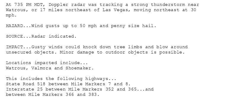
Special Weather Statement issued October 20 at 7:35PM MDT by NWS Albuquerque NM Additional Details Here.

At 735 PM MDT, Doppler radar was tracking a strong thunderstorm near
Watrous, or 17 miles northeast of Las Vegas, moving northeast at 30
mph.

HAZARD...Wind gusts up to 50 mph and penny size hail.

SOURCE...Radar indicated.

IMPACT...Gusty winds could knock down tree limbs and blow around
unsecured objects. Minor damage to outdoor objects is possible.

Locations impacted include...
Watrous, Valmora and Shoemaker.

This includes the following highways...
State Road 518 between Mile Markers 7 and 8.
Interstate 25 between Mile Markers 352 and 365...and
between Mile Markers 366 and 383.
0
AFabq.nws-bot.us

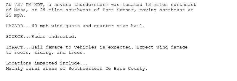
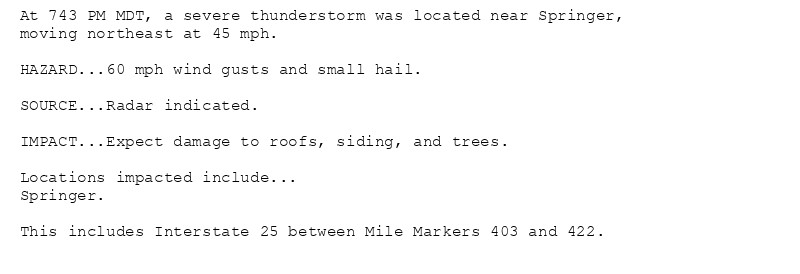
🚨 Severe Thunderstorm Warning issued October 20 at 7:43PM MDT until October 20 at 8:00PM MDT by NWS Albuquerque NM 🚨 Additional Details Here.

At 743 PM MDT, a severe thunderstorm was located near Springer,
moving northeast at 45 mph.

HAZARD...60 mph wind gusts and small hail.

SOURCE...Radar indicated.

IMPACT...Expect damage to roofs, siding, and trees.

Locations impacted include...
Springer.

This includes Interstate 25 between Mile Markers 403 and 422.
0
AFabq.nws-bot.us

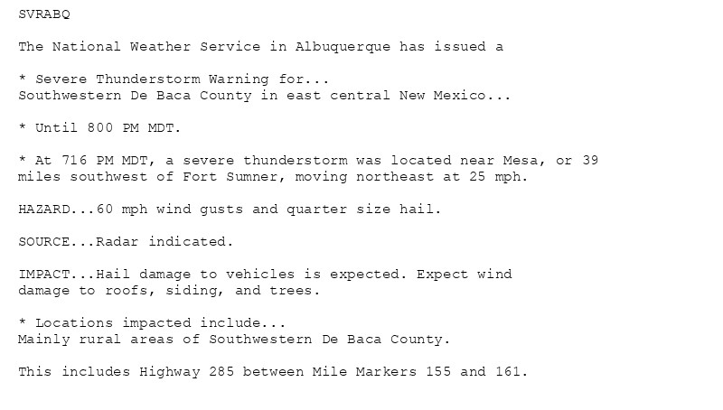
🚨 Severe Thunderstorm Warning issued October 20 at 7:16PM MDT until October 20 at 8:00PM MDT by NWS Albuquerque NM 🚨 Additional Details Here.

SVRABQ

The National Weather Service in Albuquerque has issued a

* Severe Thunderstorm Warning for...
Southwestern De Baca County in east central New Mexico...

* Until 800 PM MDT.

* At 716 PM MDT, a severe thunderstorm was located near Mesa, or 39
miles southwest of Fort Sumner, moving northeast at 25 mph.

HAZARD...60 mph wind gusts and quarter size hail.

SOURCE...Radar indicated.

IMPACT...Hail damage to vehicles is expected. Expect wind
damage to roofs, siding, and trees.

* Locations impacted include...
Mainly rural areas of Southwestern De Baca County.

This includes Highway 285 between Mile Markers 155 and 161.
0
AFabq.nws-bot.us

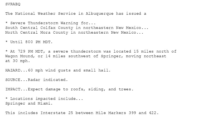
🚨 Severe Thunderstorm Warning issued October 20 at 7:29PM MDT until October 20 at 8:00PM MDT by NWS Albuquerque NM 🚨 Additional Details Here.

SVRABQ

The National Weather Service in Albuquerque has issued a

* Severe Thunderstorm Warning for...
South Central Colfax County in northeastern New Mexico...
North Central Mora County in northeastern New Mexico...

* Until 800 PM MDT.

* At 729 PM MDT, a severe thunderstorm was located 15 miles north of
Wagon Mound, or 14 miles southwest of Springer, moving northeast
at 30 mph.

HAZARD...60 mph wind gusts and small hail.

SOURCE...Radar indicated.

IMPACT...Expect damage to roofs, siding, and trees.

* Locations impacted include...
Springer and Miami.

This includes Interstate 25 between Mile Markers 399 and 422.
0
AF
Alerts from NWS Albuquerque NM (UNOFFICIAL)
@abq.nws-bot.us
Unofficial bot sharing alerts from NWS Albuquerque NM. This account is not monitored. Contact @wandrme.paxex.aero if needed.
258 followers1 following183 posts