BLUE
AF
Alerts from NWS Eureka CA (UNOFFICIAL)
@acv.nws-bot.us
Unofficial bot sharing alerts from NWS Eureka CA. This account is not monitored. Contact @wandrme.paxex.aero if needed.
124 followers1 following53 posts
AFacv.nws-bot.us

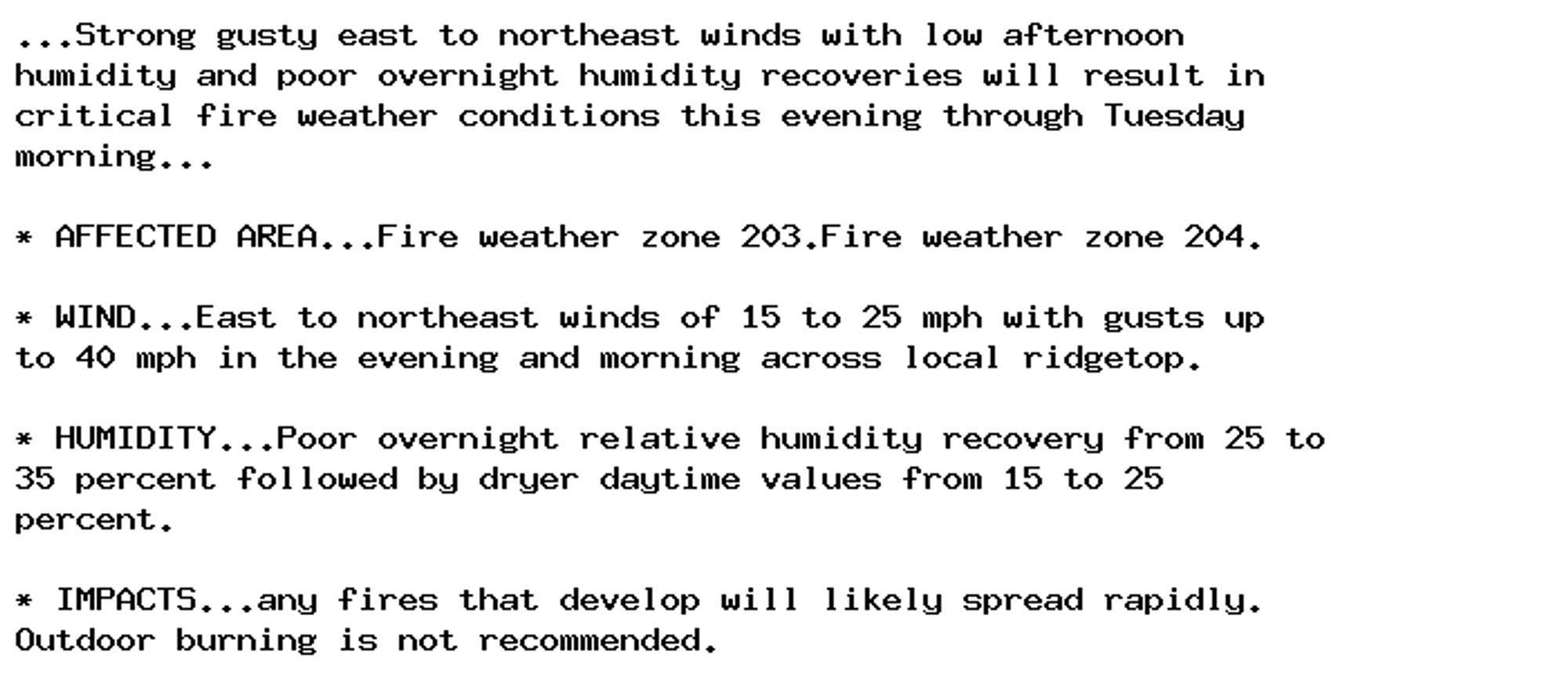
Red Flag Warning issued September 29 at 6:01PM PDT until October 1 at 11:00AM PDT by NWS Eureka CA Additional Details Here.

...Strong gusty east to northeast winds with low afternoon
humidity and poor overnight humidity recoveries will result in
critical fire weather conditions this evening through Tuesday
morning...

* AFFECTED AREA...Fire weather zone 203.Fire weather zone 204.

* WIND...East to northeast winds of 15 to 25 mph with gusts up
to 40 mph in the evening and morning across local ridgetop.

* HUMIDITY...Poor overnight relative humidity recovery from 25 to
35 percent followed by dryer daytime values from 15 to 25
percent.

* IMPACTS...any fires that develop will likely spread rapidly.
Outdoor burning is not recommended.
0
AFacv.nws-bot.us

Small Craft Advisory issued September 29 at 3:00PM PDT until September 30 at 3:00PM PDT by NWS Eureka CA Additional Details Here.

* WHAT...North winds 15 to 25 kt with localized gusts to 40 kt
and seas 7 to 11 feet.

* WHERE...Pt St George to Cape Mendocino out 10 nm.

* WHEN...Until 3 PM PDT Monday.

* IMPACTS...Conditions will be hazardous to small craft.
0
AFacv.nws-bot.us

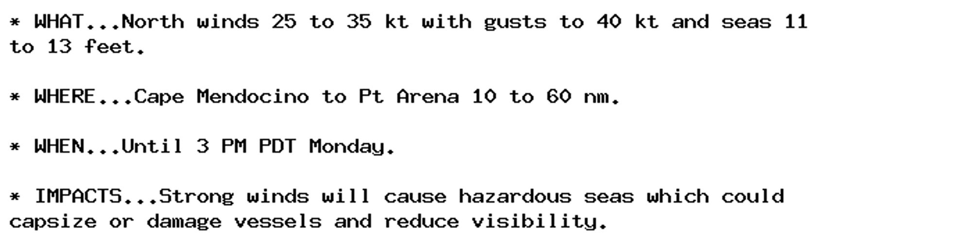
Gale Warning issued September 29 at 3:00PM PDT until September 30 at 3:00PM PDT by NWS Eureka CA Additional Details Here.

* WHAT...North winds 25 to 35 kt with gusts to 45 kt and seas 10
to 13 feet.

* WHERE...Cape Mendocino to Pt Arena 10 to 60 nm.

* WHEN...Until 3 PM PDT Monday.

* IMPACTS...Strong winds will cause hazardous seas which could
capsize or damage vessels and reduce visibility.
0
AFacv.nws-bot.us

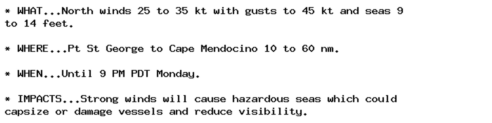
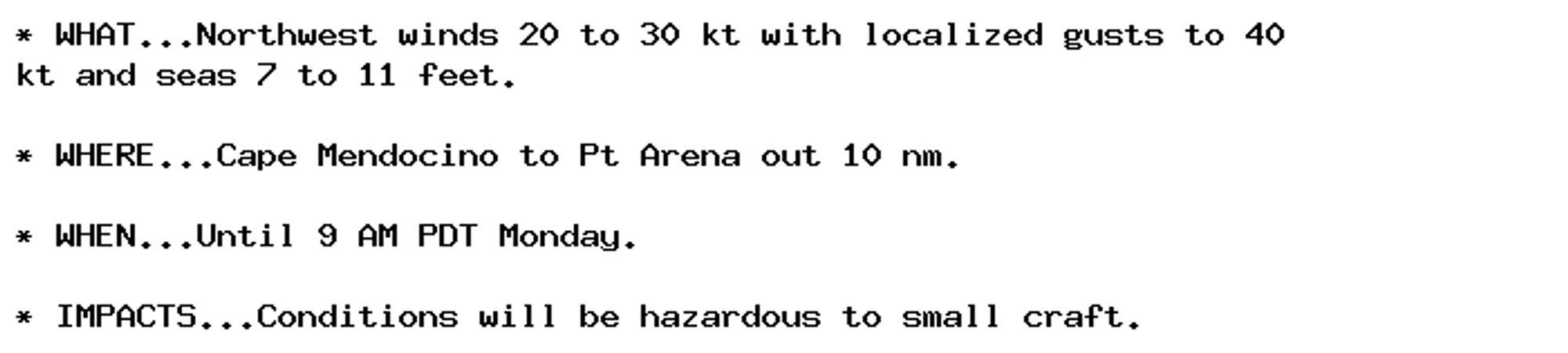
Gale Warning issued September 29 at 3:00PM PDT until September 30 at 9:00PM PDT by NWS Eureka CA Additional Details Here.

* WHAT...North winds 25 to 35 kt with gusts to 45 kt and seas 9
to 14 feet.

* WHERE...Pt St George to Cape Mendocino 10 to 60 nm.

* WHEN...Until 9 PM PDT Monday.

* IMPACTS...Strong winds will cause hazardous seas which could
capsize or damage vessels and reduce visibility.
0
AFacv.nws-bot.us

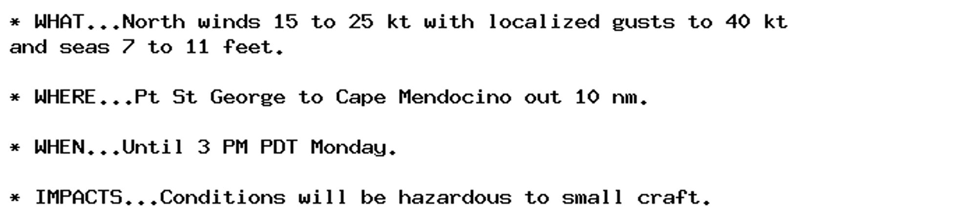
Small Craft Advisory issued September 29 at 3:00PM PDT until September 30 at 9:00AM PDT by NWS Eureka CA Additional Details Here.

* WHAT...Northwest winds 15 to 25 kt with localized gusts to 40
kt and seas 6 to 11 feet.

* WHERE...Cape Mendocino to Pt Arena out 10 nm.

* WHEN...Until 9 AM PDT Monday.

* IMPACTS...Conditions will be hazardous to small craft.
0
AFacv.nws-bot.us

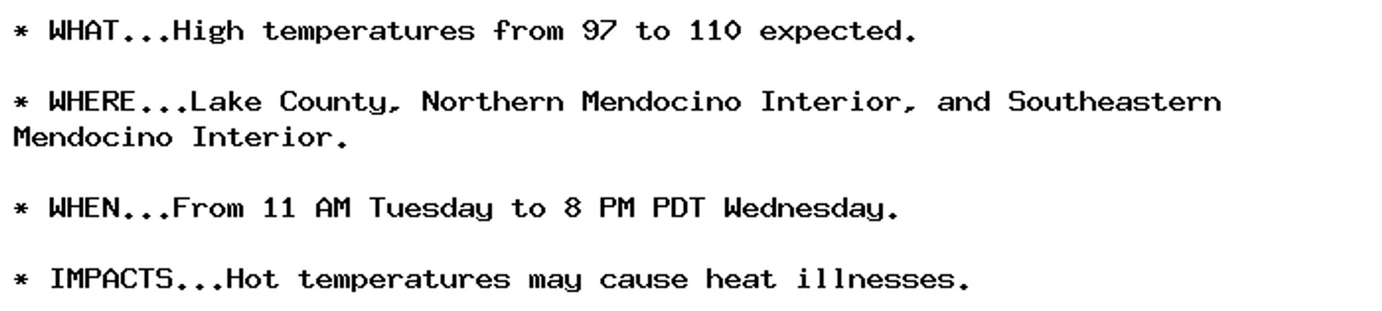
Heat Advisory issued September 29 at 12:09PM PDT until October 2 at 8:00PM PDT by NWS Eureka CA Additional Details Here.

* WHAT...High temperatures from 97 to 110 expected.

* WHERE...Lake County, Northern Mendocino Interior, and Southeastern
Mendocino Interior.

* WHEN...From 11 AM Tuesday to 8 PM PDT Wednesday.

* IMPACTS...Hot temperatures may cause heat illnesses.
0
AFacv.nws-bot.us

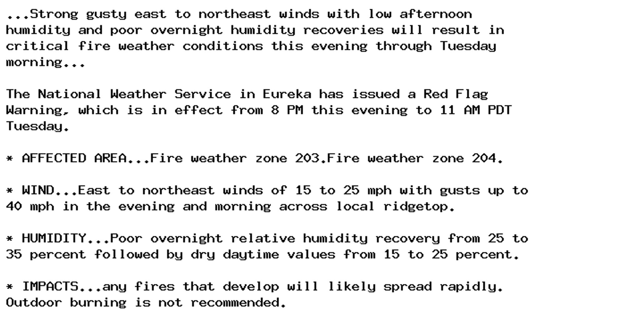
Red Flag Warning issued September 29 at 10:04AM PDT until October 1 at 11:00AM PDT by NWS Eureka CA Additional Details Here.

...Strong gusty east to northeast winds with low afternoon
humidity and poor overnight humidity recoveries will result in
critical fire weather conditions this evening through Tuesday
morning...

The National Weather Service in Eureka has issued a Red Flag
Warning, which is in effect from 8 PM this evening to 11 AM PDT
Tuesday.

* AFFECTED AREA...Fire weather zone 203.Fire weather zone 204.

* WIND...East to northeast winds of 15 to 25 mph with gusts up to
40 mph in the evening and morning across local ridgetop.

* HUMIDITY...Poor overnight relative humidity recovery from 25 to
35 percent followed by dry daytime values from 15 to 25 percent.

* IMPACTS...any fires that develop will likely spread rapidly.
Outdoor burning is not recommended.
0
AFacv.nws-bot.us

Small Craft Advisory issued September 29 at 8:57AM PDT until September 30 at 9:00AM PDT by NWS Eureka CA Additional Details Here.

* WHAT...Northwest winds 20 to 30 kt with localized gusts to 40
kt and seas 7 to 11 feet.

* WHERE...Cape Mendocino to Pt Arena out 10 nm.

* WHEN...Until 9 AM PDT Monday.

* IMPACTS...Conditions will be hazardous to small craft.
0
AFacv.nws-bot.us

Small Craft Advisory issued September 29 at 8:57AM PDT until September 30 at 3:00PM PDT by NWS Eureka CA Additional Details Here.

* WHAT...North winds 20 to 30 kt with localized gusts to 40 kt
and seas 7 to 12 feet.

* WHERE...Pt St George to Cape Mendocino out 10 nm.

* WHEN...Until 3 PM PDT Monday.

* IMPACTS...Conditions will be hazardous to small craft.
0
AFacv.nws-bot.us

Gale Warning issued September 29 at 8:57AM PDT until September 30 at 3:00PM PDT by NWS Eureka CA Additional Details Here.

* WHAT...North winds 25 to 35 kt with gusts to 40 kt and seas 11
to 13 feet.

* WHERE...Cape Mendocino to Pt Arena 10 to 60 nm.

* WHEN...Until 3 PM PDT Monday.

* IMPACTS...Strong winds will cause hazardous seas which could
capsize or damage vessels and reduce visibility.
0
AF
Alerts from NWS Eureka CA (UNOFFICIAL)
@acv.nws-bot.us
Unofficial bot sharing alerts from NWS Eureka CA. This account is not monitored. Contact @wandrme.paxex.aero if needed.
124 followers1 following53 posts