BLUE
Profile banner
JB
James Brooks Cascade
@alaska.bsky.social
Statehouse and politics reporter for the Alaska Beacon. Juneauite. Formerly with the Anchorage Daily News, Juneau Empire, Kodiak Daily Mirror and the Fairbanks Daily News-Miner.
505 followers373 following793 posts
JBalaska.bsky.social

Juneau is looking particularly fine today, with the big storm having gone well to the south. #Alaska

The rising sun illuminates the top of Mount Juneau, with the town below in shadow and a cargo barge preparing to leave
Striped clouds are visible above dark blue mountains
An approaching cruise ship is bracketed by two worn pier pilings
1
JBalaska.bsky.social

Termination dust spotted in Juneau! Winter’s on the way! #Alaska

A totem pole stands in front of the snow-dusted top of Mount Juneau
2
Reposted by James Brooks Cascade
TEtomellison123.bsky.social

At the risk of shameless self promotion: www.mcsweeneys.net/articles/the...

2
JBalaska.bsky.social

Dang -- did Whitehorse get it as late as Fairbanks did?

0
JBalaska.bsky.social

The national weather service is predicting a hurricane-force storm for us on Monday, but for the moment, sunset rainbow. #Alaska

A brilliant rainbow is reflected in a placid lake a mid cloudy skies with patches of blue.
A brilliant rainbow is reflected in a placid lake beyond some bushes
1
Reposted by James Brooks Cascade
AFjnu.nws-bot.us

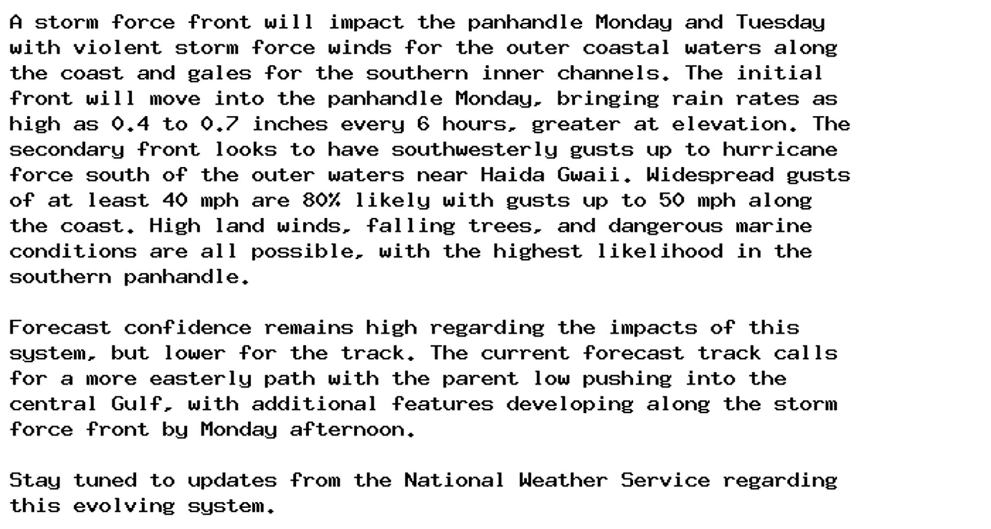
Special Weather Statement issued September 28 at 2:46PM AKDT by NWS Juneau AK Additional Details Here.

A storm force front will impact the panhandle Monday and Tuesday
with violent storm force winds for the outer coastal waters along
the coast and gales for the southern inner channels. The initial
front will move into the panhandle Monday, bringing rain rates as
high as 0.4 to 0.7 inches every 6 hours, greater at elevation. The
secondary front looks to have southwesterly gusts up to hurricane
force south of the outer waters near Haida Gwaii. Widespread gusts
of at least 40 mph are 80% likely with gusts up to 50 mph along
the coast. High land winds, falling trees, and dangerous marine
conditions are all possible, with the highest likelihood in the
southern panhandle.

Forecast confidence remains high regarding the impacts of this
system, but lower for the track. The current forecast track calls
for a more easterly path with the parent low pushing into the
central Gulf, with additional features developing along the storm
force front by Monday afternoon.

Stay tuned to updates from the National Weather Service regarding
this evolving system.
0
Reposted by James Brooks Cascade
AFjnu.nws-bot.us

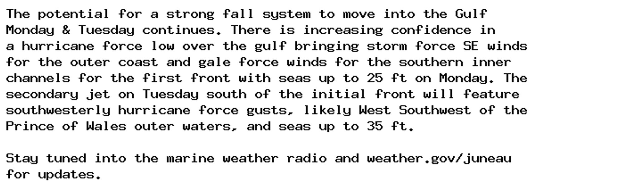
Marine Weather Statement issued September 28 at 2:46PM AKDT by NWS Juneau AK Additional Details Here.

The potential for a strong fall system to move into the Gulf
Monday & Tuesday continues. There is increasing confidence in
a hurricane force low over the gulf bringing storm force SE winds
for the outer coast and gale force winds for the southern inner
channels for the first front with seas up to 25 ft on Monday. The
secondary jet on Tuesday south of the initial front will feature
southwesterly hurricane force gusts, likely West Southwest of the
Prince of Wales outer waters, and seas up to 35 ft.

Stay tuned into the marine weather radio and weather.gov/juneau
for updates.
0
JBalaska.bsky.social

Hey, is there a source for this or a way to link it outside Bluesky?

1
JBalaska.bsky.social

UNC with different helmets?

0
Profile banner
JB
James Brooks Cascade
@alaska.bsky.social
Statehouse and politics reporter for the Alaska Beacon. Juneauite. Formerly with the Anchorage Daily News, Juneau Empire, Kodiak Daily Mirror and the Fairbanks Daily News-Miner.
505 followers373 following793 posts