BLUE
AF
Alerts from NWS Quad Cities IA/IL (UNOFFICIAL)
@dvn.nws-bot.us
Unofficial bot sharing alerts from NWS Quad Cities IA/IL. This account is not monitored. Contact @wandrme.paxex.aero if needed.
142 followers1 following20 posts
AFdvn.nws-bot.us

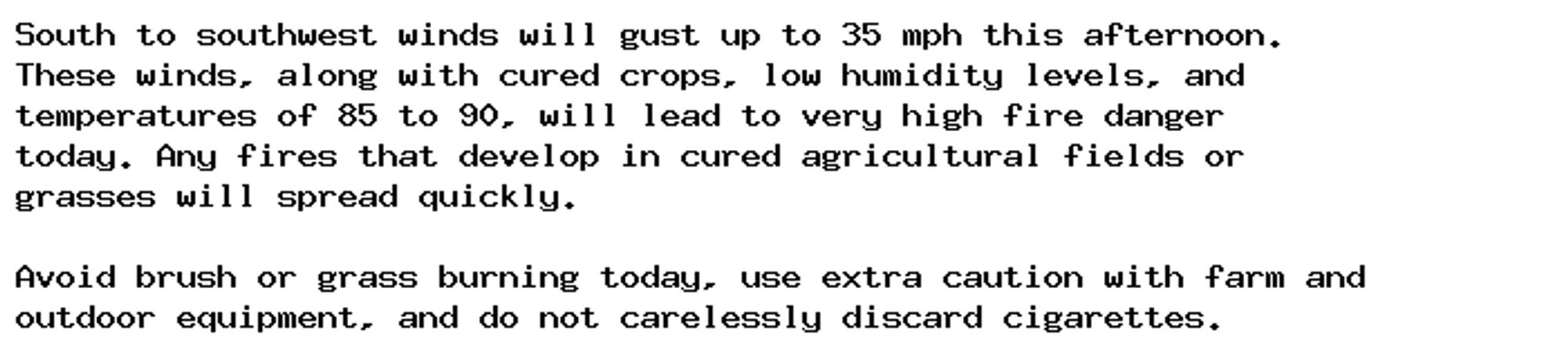
Special Weather Statement issued October 5 at 11:42AM CDT by NWS Quad Cities IA IL Additional Details Here.

South to southwest winds will gust up to 35 mph this afternoon.
These winds, along with cured crops, low humidity levels and
temperatures of 85 to 90, will lead to very high to low-end
extreme fire danger today. Any fires that develop in cured
agricultural fields will spread quickly and become difficult to
control. If conditions worsen further, a red flag warning may be
needed for this area this afternoon.

Avoid brush or grass burning today, use extra caution with farm and
outdoor equipment, and do not carelessly discard cigarettes.
0
AFdvn.nws-bot.us

Special Weather Statement issued October 5 at 3:15AM CDT by NWS Quad Cities IA IL Additional Details Here.

South to southwest winds will gust up to 35 mph this afternoon.
These winds, along with cured crops, low humidity levels, and
temperatures of 85 to 90, will lead to very high fire danger
today. Any fires that develop in cured agricultural fields or
grasses will spread quickly.

Avoid brush or grass burning today, use extra caution with farm and
outdoor equipment, and do not carelessly discard cigarettes.
0
AFdvn.nws-bot.us

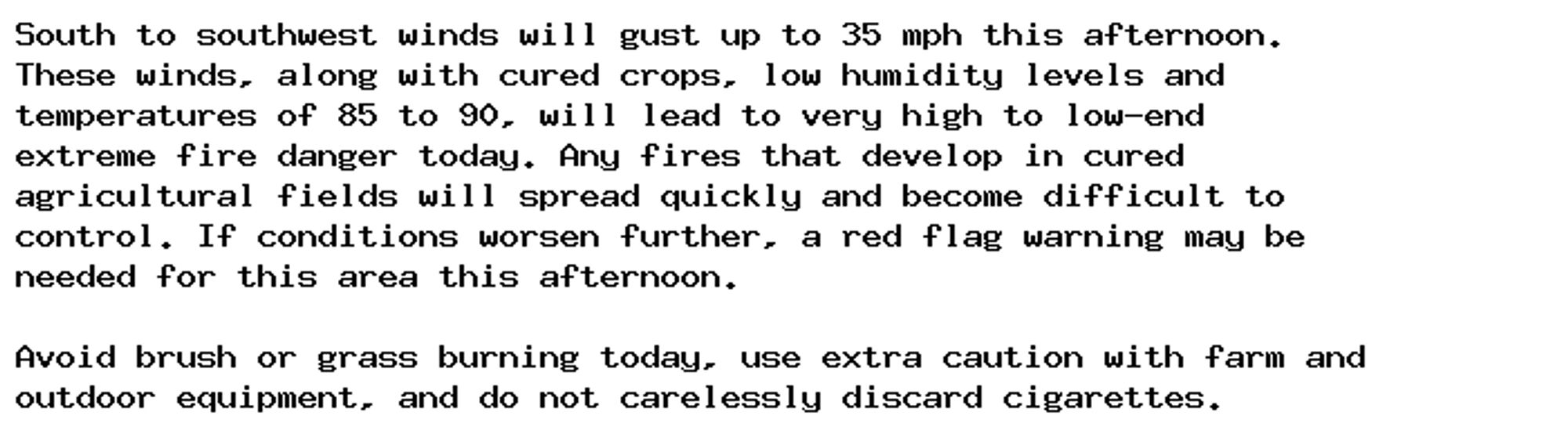
Special Weather Statement issued October 4 at 7:15AM CDT by NWS Quad Cities IA IL Additional Details Here.

At 714 AM CDT, Doppler radar was tracking a strong thunderstorm 7
miles south of Alexandria, or 9 miles north of Canton, moving east at
30 mph.

HAZARD...Nickel size hail.

SOURCE...Radar indicated.

IMPACT...Minor damage to outdoor objects is possible.

Locations impacted include...
Warsaw, Augusta, Wayland, Bowen, West Point, Alexandria, Winchester,
Denver, St. Patrick, Gregory Landing, Tioga, Sutter, Stillwell, and
Hancock County Fairgrounds.
0
AFdvn.nws-bot.us

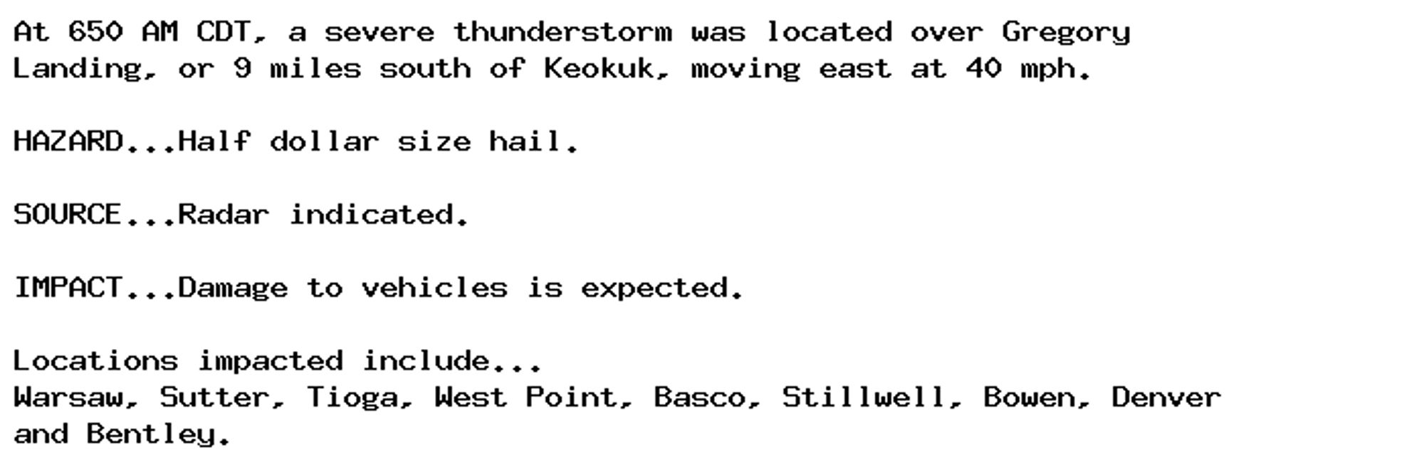
🚨 Severe Thunderstorm Warning issued October 4 at 6:51AM CDT until October 4 at 7:15AM CDT by NWS Quad Cities IA IL 🚨 Additional Details Here.

At 650 AM CDT, a severe thunderstorm was located over Gregory
Landing, or 9 miles south of Keokuk, moving east at 40 mph.

HAZARD...Half dollar size hail.

SOURCE...Radar indicated.

IMPACT...Damage to vehicles is expected.

Locations impacted include...
Warsaw, Sutter, Tioga, West Point, Basco, Stillwell, Bowen, Denver
and Bentley.
0
AFdvn.nws-bot.us

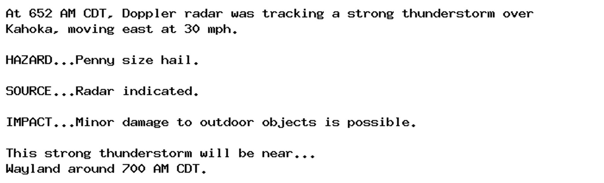
Special Weather Statement issued October 4 at 6:52AM CDT by NWS Quad Cities IA IL Additional Details Here.

At 652 AM CDT, Doppler radar was tracking a strong thunderstorm over
Kahoka, moving east at 30 mph.

HAZARD...Penny size hail.

SOURCE...Radar indicated.

IMPACT...Minor damage to outdoor objects is possible.

This strong thunderstorm will be near...
Wayland around 700 AM CDT.
0
AFdvn.nws-bot.us

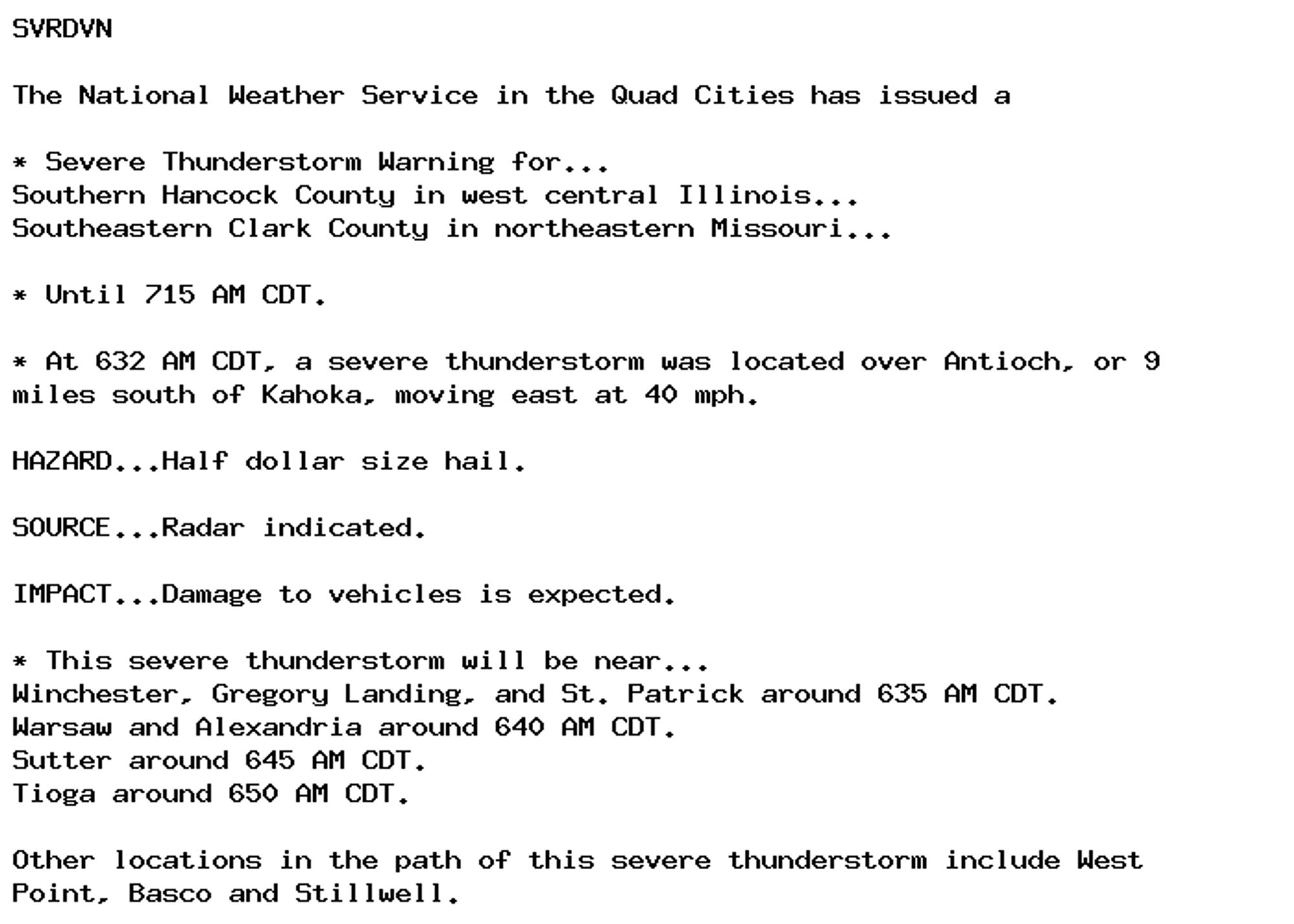
🚨 Severe Thunderstorm Warning issued October 4 at 6:32AM CDT until October 4 at 7:15AM CDT by NWS Quad Cities IA IL 🚨 Additional Details Here.

SVRDVN

The National Weather Service in the Quad Cities has issued a

* Severe Thunderstorm Warning for...
Southern Hancock County in west central Illinois...
Southeastern Clark County in northeastern Missouri...

* Until 715 AM CDT.

* At 632 AM CDT, a severe thunderstorm was located over Antioch, or 9
miles south of Kahoka, moving east at 40 mph.

HAZARD...Half dollar size hail.

SOURCE...Radar indicated.

IMPACT...Damage to vehicles is expected.

* This severe thunderstorm will be near...
Winchester, Gregory Landing, and St. Patrick around 635 AM CDT.
Warsaw and Alexandria around 640 AM CDT.
Sutter around 645 AM CDT.
Tioga around 650 AM CDT.

Other locations in the path of this severe thunderstorm include West
Point, Basco and Stillwell.
0
AFdvn.nws-bot.us

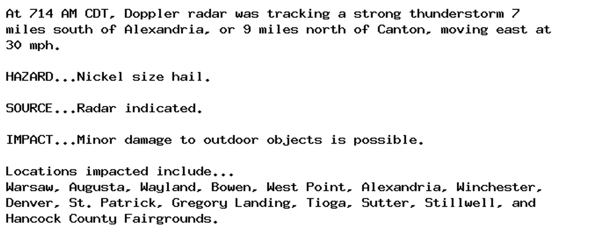
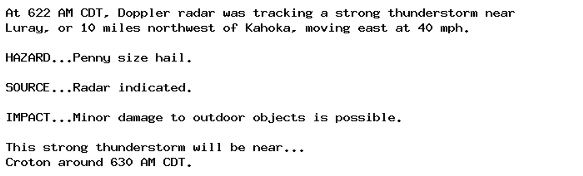
Special Weather Statement issued October 4 at 6:22AM CDT by NWS Quad Cities IA IL Additional Details Here.

At 622 AM CDT, Doppler radar was tracking a strong thunderstorm near
Luray, or 10 miles northwest of Kahoka, moving east at 40 mph.

HAZARD...Penny size hail.

SOURCE...Radar indicated.

IMPACT...Minor damage to outdoor objects is possible.

This strong thunderstorm will be near...
Croton around 630 AM CDT.
0
AFdvn.nws-bot.us

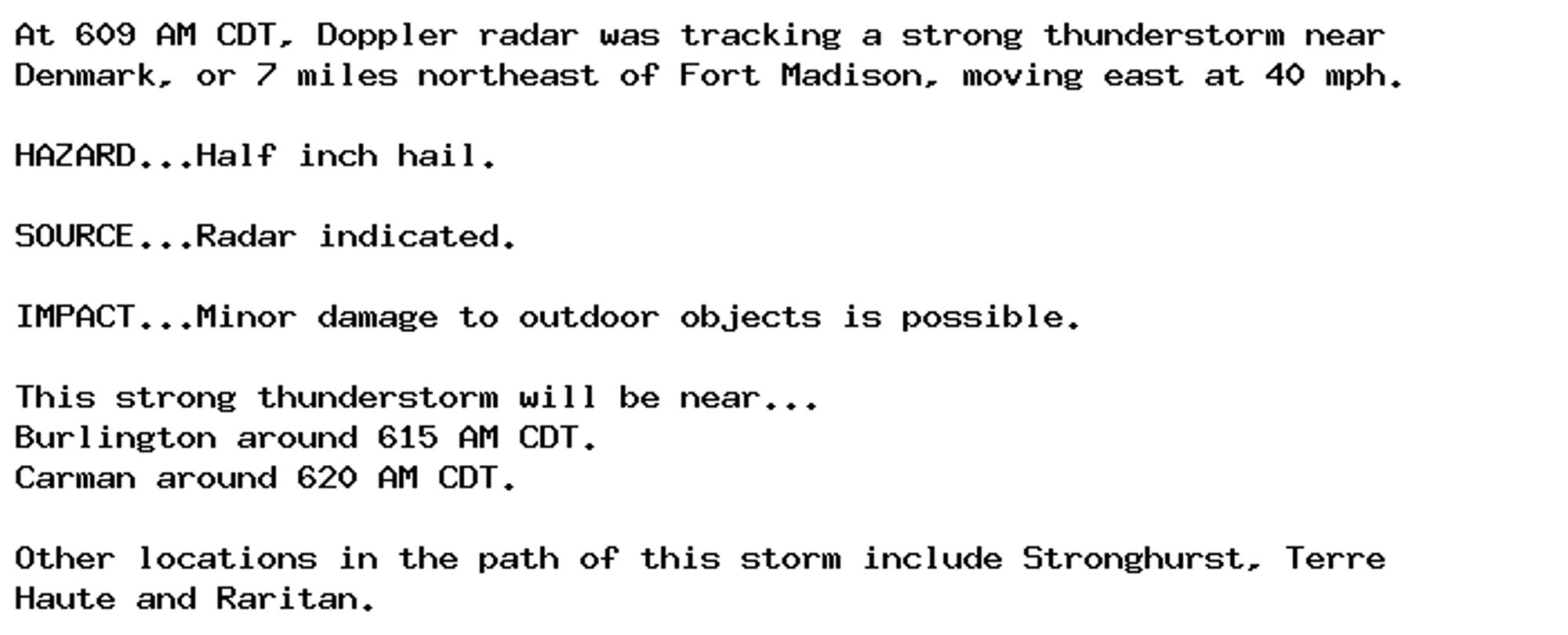
Special Weather Statement issued October 4 at 6:09AM CDT by NWS Quad Cities IA IL Additional Details Here.

At 609 AM CDT, Doppler radar was tracking a strong thunderstorm near
Denmark, or 7 miles northeast of Fort Madison, moving east at 40 mph.

HAZARD...Half inch hail.

SOURCE...Radar indicated.

IMPACT...Minor damage to outdoor objects is possible.

This strong thunderstorm will be near...
Burlington around 615 AM CDT.
Carman around 620 AM CDT.

Other locations in the path of this storm include Stronghurst, Terre
Haute and Raritan.
0
AFdvn.nws-bot.us

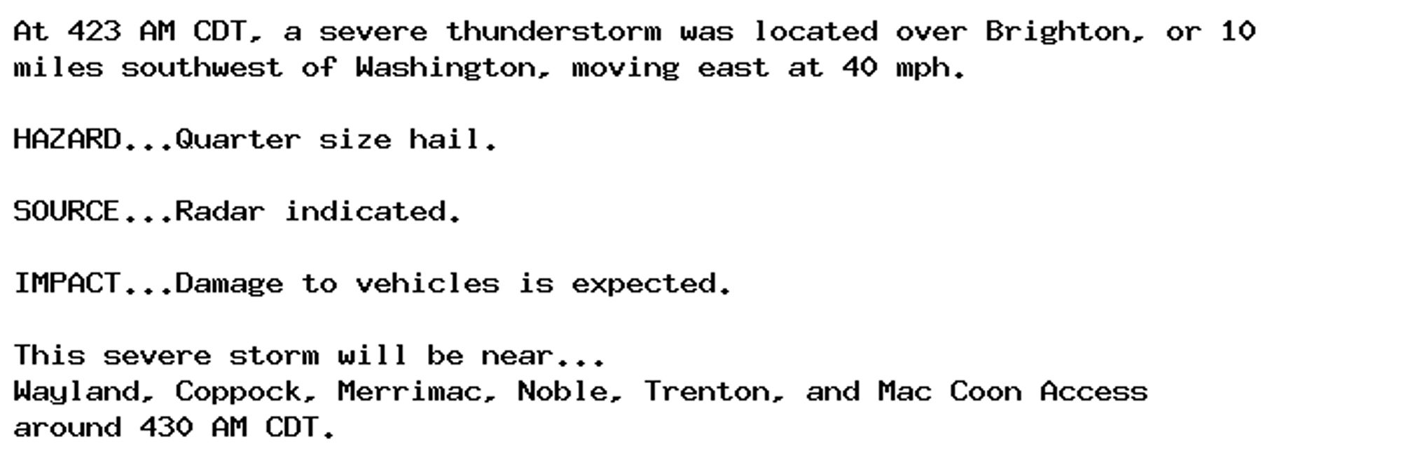
🚨 Severe Thunderstorm Warning issued October 4 at 4:24AM CDT until October 4 at 4:45AM CDT by NWS Quad Cities IA IL 🚨 Additional Details Here.

At 423 AM CDT, a severe thunderstorm was located over Brighton, or 10
miles southwest of Washington, moving east at 40 mph.

HAZARD...Quarter size hail.

SOURCE...Radar indicated.

IMPACT...Damage to vehicles is expected.

This severe storm will be near...
Wayland, Coppock, Merrimac, Noble, Trenton, and Mac Coon Access
around 430 AM CDT.
0
AFdvn.nws-bot.us

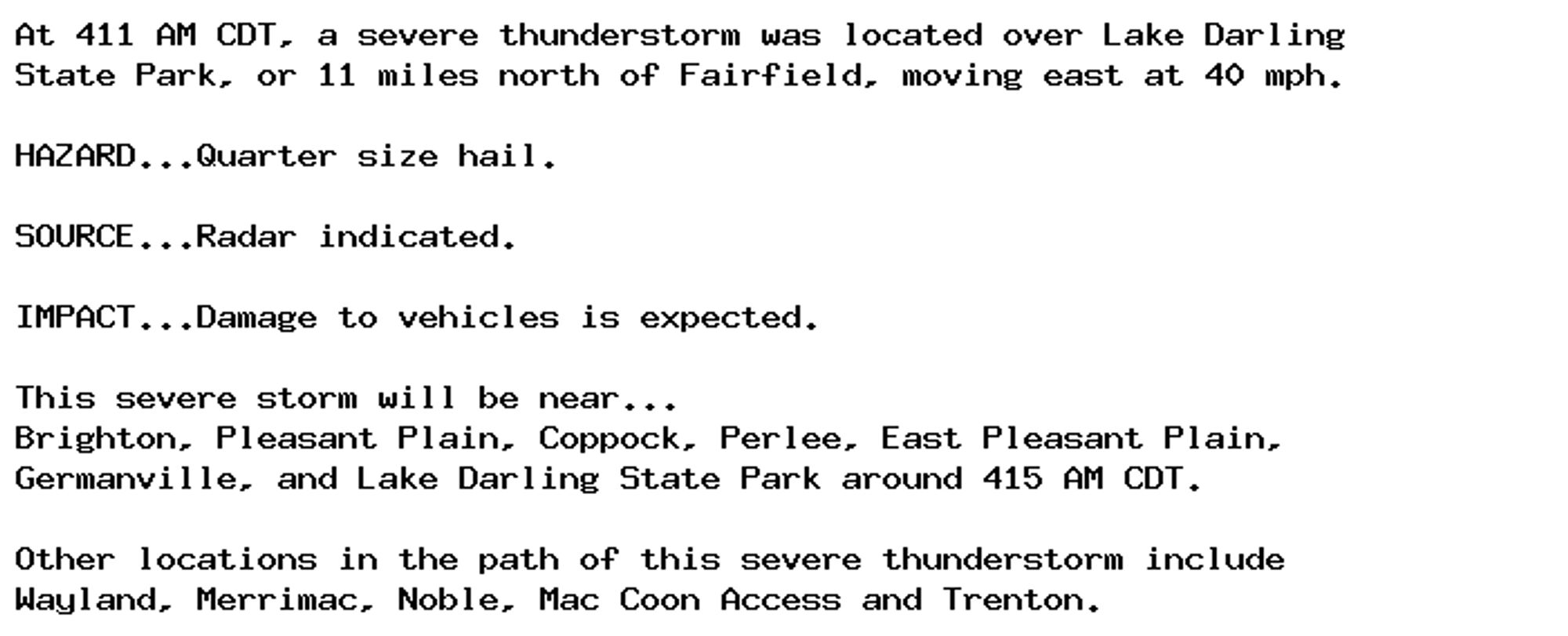
🚨 Severe Thunderstorm Warning issued October 4 at 4:12AM CDT until October 4 at 4:45AM CDT by NWS Quad Cities IA IL 🚨 Additional Details Here.

At 411 AM CDT, a severe thunderstorm was located over Lake Darling
State Park, or 11 miles north of Fairfield, moving east at 40 mph.

HAZARD...Quarter size hail.

SOURCE...Radar indicated.

IMPACT...Damage to vehicles is expected.

This severe storm will be near...
Brighton, Pleasant Plain, Coppock, Perlee, East Pleasant Plain,
Germanville, and Lake Darling State Park around 415 AM CDT.

Other locations in the path of this severe thunderstorm include
Wayland, Merrimac, Noble, Mac Coon Access and Trenton.
0
AF
Alerts from NWS Quad Cities IA/IL (UNOFFICIAL)
@dvn.nws-bot.us
Unofficial bot sharing alerts from NWS Quad Cities IA/IL. This account is not monitored. Contact @wandrme.paxex.aero if needed.
142 followers1 following20 posts