BLUE
AF
Alerts from NWS Guam (UNOFFICIAL)
@gum.nws-bot.us
Unofficial bot sharing alerts from NWS Guam. This account is not monitored. Contact @wandrme.paxex.aero if needed.
83 followers1 following16 posts
AFgum.nws-bot.us

Special Weather Statement issued October 7 at 5:50AM ChST by NWS Tiyan GU Additional Details Here.

.CANCELLATION OF SPECIAL WEATHER STATEMENT...

Tropical Depression 21W has moved to near 20N146E. Conditions at
Agrihan, Pagan and Alamagan have improved. Showers are expected to
remain in the area and seas will remain choppy.
0
AFgum.nws-bot.us

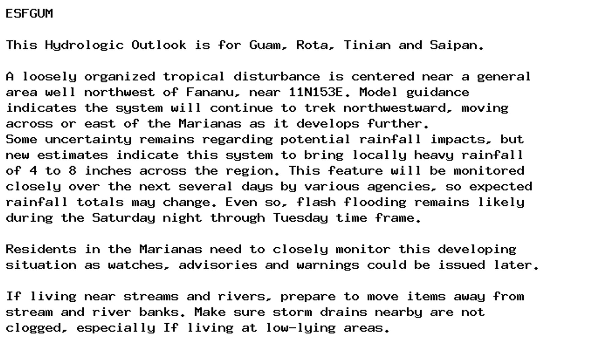
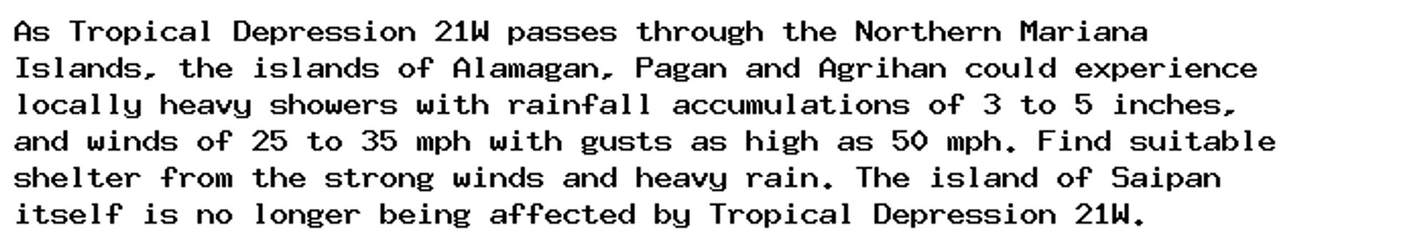
Special Weather Statement issued October 7 at 12:13AM ChST by NWS Tiyan GU Additional Details Here.

As Tropical Depression 21W passes through the Northern Mariana
Islands, the islands of Alamagan, Pagan and Agrihan could experience
locally heavy showers with rainfall accumulations of 3 to 5 inches,
and winds of 25 to 35 mph with gusts as high as 50 mph. Find suitable
shelter from the strong winds and heavy rain. The island of Saipan
itself is no longer being affected by Tropical Depression 21W.
Conditions will improve over the day as Tropical Depression 21W moves
away from these islands.
0
AFgum.nws-bot.us

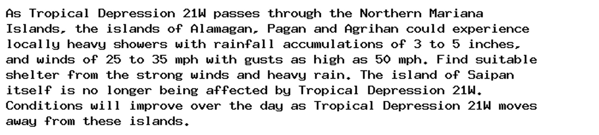
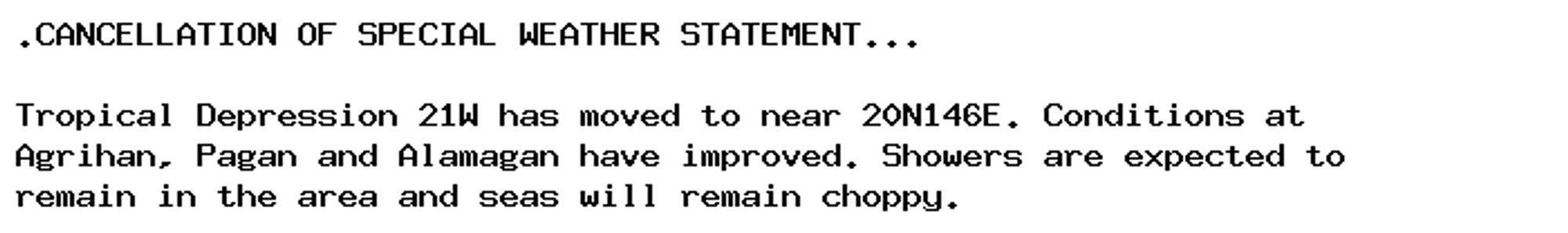
Special Weather Statement issued October 6 at 10:09PM ChST by NWS Tiyan GU Additional Details Here.

As Tropical Depression 21W passes through the Northern Mariana
Islands, the islands of Alamagan, Pagan and Agrihan could experience
locally heavy showers with rainfall accumulations of 3 to 5 inches,
and winds of 25 to 35 mph with gusts as high as 50 mph. Find suitable
shelter from the strong winds and heavy rain. The island of Saipan
itself is no longer being affected by Tropical Depression 21W.
0
AFgum.nws-bot.us

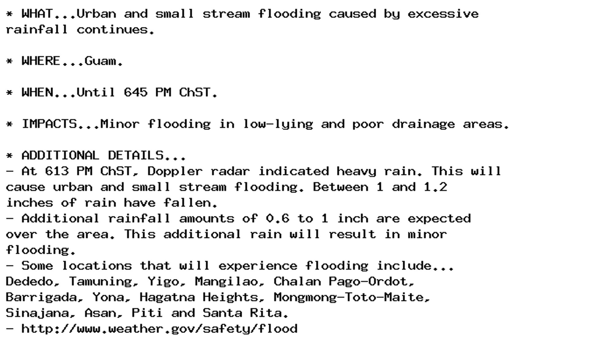
Flood Advisory issued October 5 at 6:14PM ChST until October 5 at 6:45PM ChST by NWS Tiyan GU Additional Details Here.

* WHAT...Urban and small stream flooding caused by excessive
rainfall continues.

* WHERE...Guam.

* WHEN...Until 645 PM ChST.

* IMPACTS...Minor flooding in low-lying and poor drainage areas.

* ADDITIONAL DETAILS...
- At 613 PM ChST, Doppler radar indicated heavy rain. This will
cause urban and small stream flooding. Between 1 and 1.2
inches of rain have fallen.
- Additional rainfall amounts of 0.6 to 1 inch are expected
over the area. This additional rain will result in minor
flooding.
- Some locations that will experience flooding include...
Dededo, Tamuning, Yigo, Mangilao, Chalan Pago-Ordot,
Barrigada, Yona, Hagatna Heights, Mongmong-Toto-Maite,
Sinajana, Asan, Piti and Santa Rita.
- http://www.weather.gov/safety/flood
0
AFgum.nws-bot.us

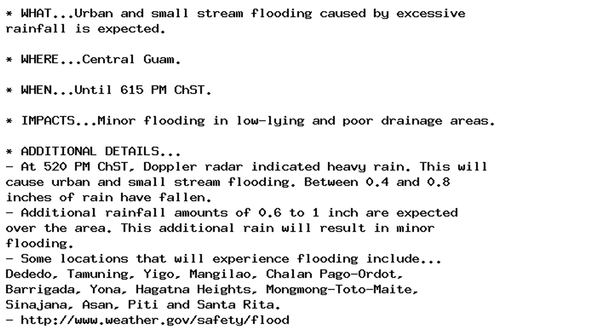
Flood Advisory issued October 5 at 5:21PM ChST until October 5 at 6:15PM ChST by NWS Tiyan GU Additional Details Here.

* WHAT...Urban and small stream flooding caused by excessive
rainfall is expected.

* WHERE...Central Guam.

* WHEN...Until 615 PM ChST.

* IMPACTS...Minor flooding in low-lying and poor drainage areas.

* ADDITIONAL DETAILS...
- At 520 PM ChST, Doppler radar indicated heavy rain. This will
cause urban and small stream flooding. Between 0.4 and 0.8
inches of rain have fallen.
- Additional rainfall amounts of 0.6 to 1 inch are expected
over the area. This additional rain will result in minor
flooding.
- Some locations that will experience flooding include...
Dededo, Tamuning, Yigo, Mangilao, Chalan Pago-Ordot,
Barrigada, Yona, Hagatna Heights, Mongmong-Toto-Maite,
Sinajana, Asan, Piti and Santa Rita.
- http://www.weather.gov/safety/flood
0
AFgum.nws-bot.us

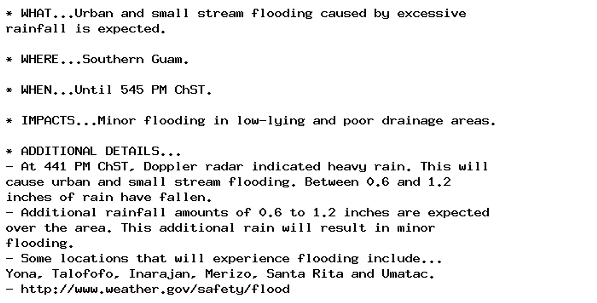
Flood Advisory issued October 5 at 4:41PM ChST until October 5 at 5:45PM ChST by NWS Tiyan GU Additional Details Here.

* WHAT...Urban and small stream flooding caused by excessive
rainfall is expected.

* WHERE...Southern Guam.

* WHEN...Until 545 PM ChST.

* IMPACTS...Minor flooding in low-lying and poor drainage areas.

* ADDITIONAL DETAILS...
- At 441 PM ChST, Doppler radar indicated heavy rain. This will
cause urban and small stream flooding. Between 0.6 and 1.2
inches of rain have fallen.
- Additional rainfall amounts of 0.6 to 1.2 inches are expected
over the area. This additional rain will result in minor
flooding.
- Some locations that will experience flooding include...
Yona, Talofofo, Inarajan, Merizo, Santa Rita and Umatac.
- http://www.weather.gov/safety/flood
0
AFgum.nws-bot.us

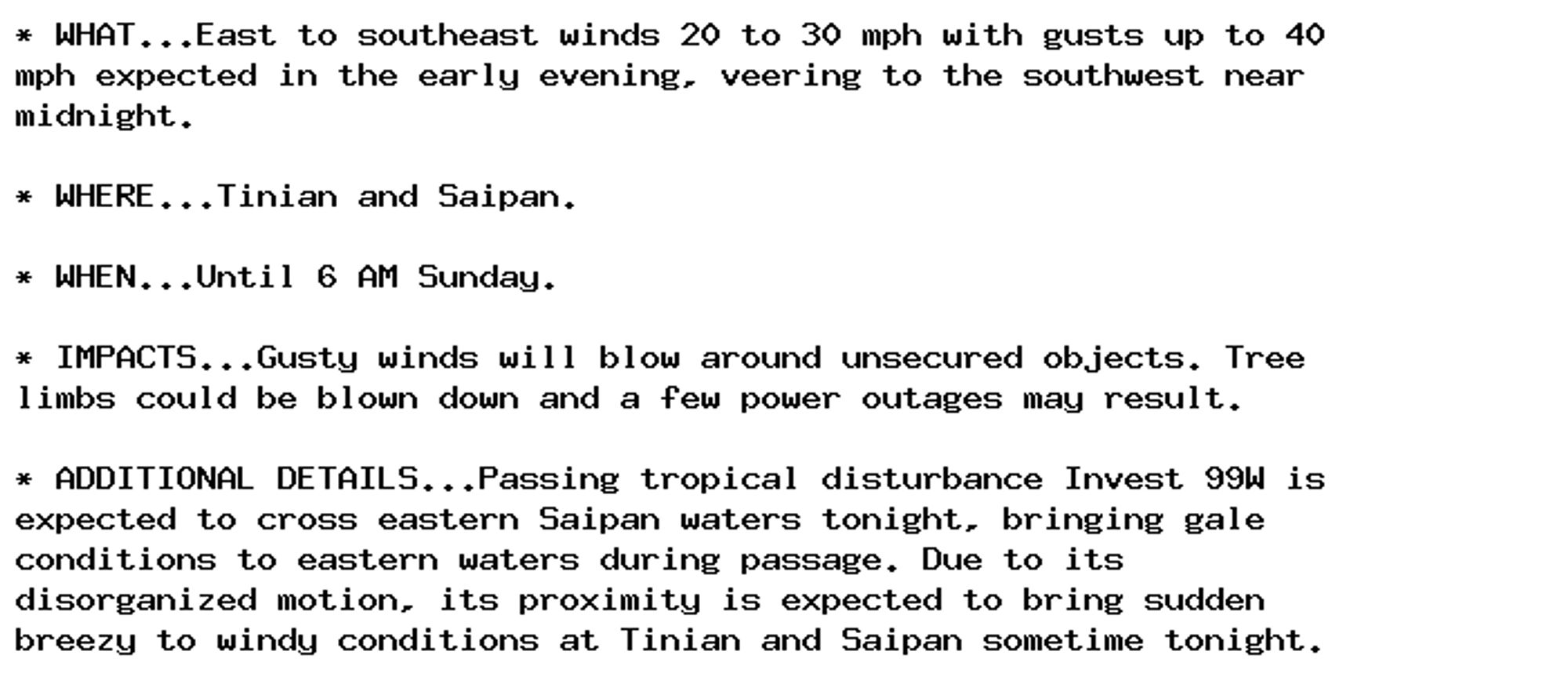
Wind Advisory issued October 5 at 3:48PM ChST until October 6 at 6:00AM ChST by NWS Tiyan GU Additional Details Here.

* WHAT...East to southeast winds 20 to 30 mph with gusts up to 40
mph expected in the early evening, veering to the southwest near
midnight.

* WHERE...Tinian and Saipan.

* WHEN...Until 6 AM Sunday.

* IMPACTS...Gusty winds will blow around unsecured objects. Tree
limbs could be blown down and a few power outages may result.

* ADDITIONAL DETAILS...Passing tropical disturbance Invest 99W is
expected to cross eastern Saipan waters tonight, bringing gale
conditions to eastern waters during passage. Due to its
disorganized motion, its proximity is expected to bring sudden
breezy to windy conditions at Tinian and Saipan sometime tonight.
0
AFgum.nws-bot.us

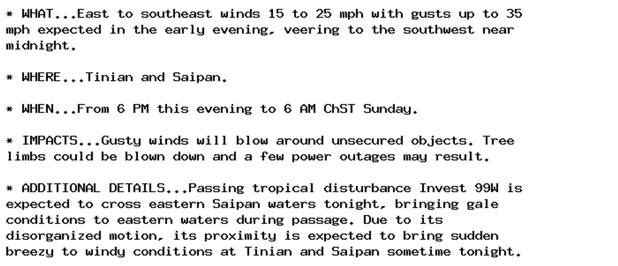
Wind Advisory issued October 5 at 3:28PM ChST until October 6 at 6:00AM ChST by NWS Tiyan GU Additional Details Here.

* WHAT...East to southeast winds 15 to 25 mph with gusts up to 35
mph expected in the early evening, veering to the southwest near
midnight.

* WHERE...Tinian and Saipan.

* WHEN...From 6 PM this evening to 6 AM ChST Sunday.

* IMPACTS...Gusty winds will blow around unsecured objects. Tree
limbs could be blown down and a few power outages may result.

* ADDITIONAL DETAILS...Passing tropical disturbance Invest 99W is
expected to cross eastern Saipan waters tonight, bringing gale
conditions to eastern waters during passage. Due to its
disorganized motion, its proximity is expected to bring sudden
breezy to windy conditions at Tinian and Saipan sometime tonight.
0
AFgum.nws-bot.us

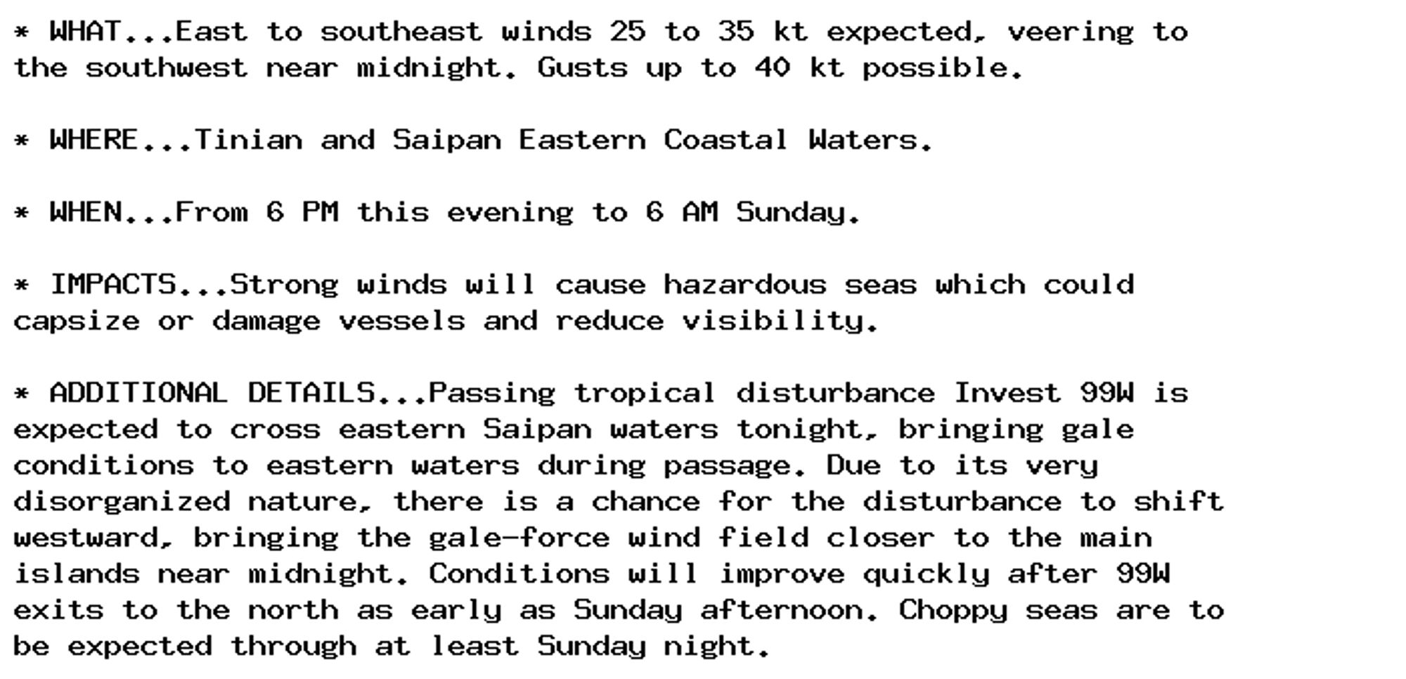
Gale Warning issued October 5 at 3:29PM ChST until October 6 at 6:00AM ChST by NWS Tiyan GU Additional Details Here.

* WHAT...East to southeast winds 25 to 35 kt expected, veering to
the southwest near midnight. Gusts up to 40 kt possible.

* WHERE...Tinian and Saipan Eastern Coastal Waters.

* WHEN...From 6 PM this evening to 6 AM Sunday.

* IMPACTS...Strong winds will cause hazardous seas which could
capsize or damage vessels and reduce visibility.

* ADDITIONAL DETAILS...Passing tropical disturbance Invest 99W is
expected to cross eastern Saipan waters tonight, bringing gale
conditions to eastern waters during passage. Due to its very
disorganized nature, there is a chance for the disturbance to shift
westward, bringing the gale-force wind field closer to the main
islands near midnight. Conditions will improve quickly after 99W
exits to the north as early as Sunday afternoon. Choppy seas are to
be expected through at least Sunday night.
0
AFgum.nws-bot.us

Hydrologic Outlook issued October 4 at 9:57PM ChST by NWS Tiyan GU Additional Details Here.

ESFGUM

This Hydrologic Outlook is for Guam, Rota, Tinian and Saipan.

A loosely organized tropical disturbance is centered near a general
area well northwest of Fananu, near 11N153E. Model guidance
indicates the system will continue to trek northwestward, moving
across or east of the Marianas as it develops further.
Some uncertainty remains regarding potential rainfall impacts, but
new estimates indicate this system to bring locally heavy rainfall
of 4 to 8 inches across the region. This feature will be monitored
closely over the next several days by various agencies, so expected
rainfall totals may change. Even so, flash flooding remains likely
during the Saturday night through Tuesday time frame.

Residents in the Marianas need to closely monitor this developing
situation as watches, advisories and warnings could be issued later.

If living near streams and rivers, prepare to move items away from
stream and river banks. Make sure storm drains nearby are not
clogged, especially If living at low-lying areas.
0
AF
Alerts from NWS Guam (UNOFFICIAL)
@gum.nws-bot.us
Unofficial bot sharing alerts from NWS Guam. This account is not monitored. Contact @wandrme.paxex.aero if needed.
83 followers1 following16 posts