BLUE
AF
Alerts from NWS Northern Indiana (UNOFFICIAL)
@iwx.nws-bot.us
Unofficial bot sharing alerts from NWS Northern Indiana. This account is not monitored. Contact @wandrme.paxex.aero if needed.
122 followers1 following16 posts
AFiwx.nws-bot.us

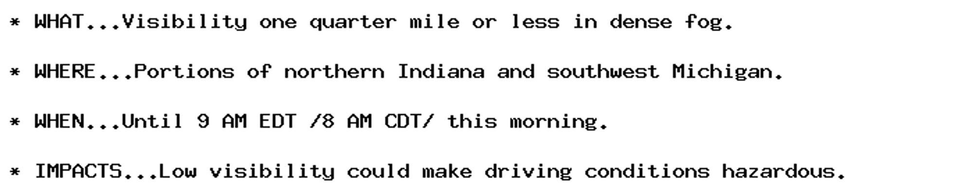
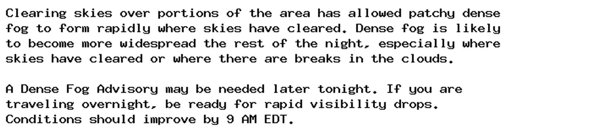
Dense Fog Advisory issued October 1 at 5:00AM EDT until October 1 at 9:00AM EDT by NWS Northern Indiana Additional Details Here.

* WHAT...Visibility one quarter mile or less in dense fog.

* WHERE...Portions of northern Indiana and southwest Michigan.

* WHEN...Until 9 AM EDT /8 AM CDT/ this morning.

* IMPACTS...Low visibility could make driving conditions hazardous.
0
AFiwx.nws-bot.us

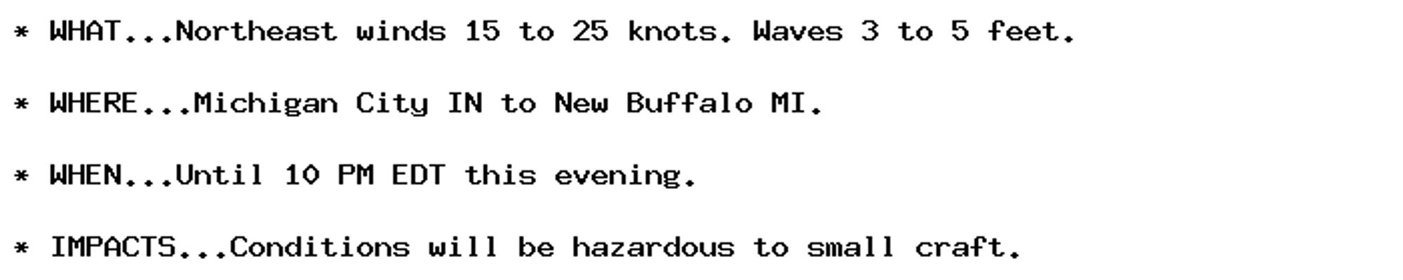
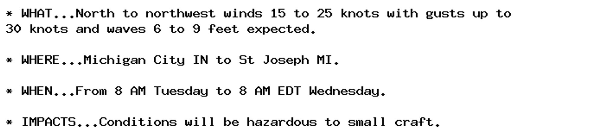
Small Craft Advisory issued October 1 at 5:04AM EDT until October 2 at 8:00AM EDT by NWS Northern Indiana Additional Details Here.

* WHAT...North winds 15 to 25 knots with gusts up to 30 knots this
afternoon becoming east to 5 to 15 knots after midnight. Waves
building to 5 to 8 feet this afternoon and evening, then
subsiding to 2 to 4 feet by Wednesday morning.

* WHERE...Michigan City IN to St Joseph MI.

* WHEN...Until 8 AM EDT Wednesday.

* IMPACTS...Conditions will be hazardous to small craft.
0
AFiwx.nws-bot.us

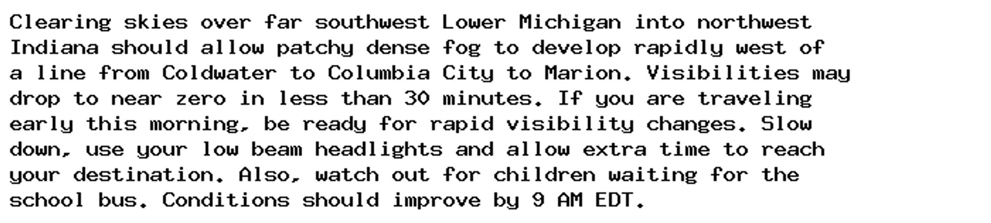
Special Weather Statement issued October 1 at 3:28AM EDT by NWS Northern Indiana Additional Details Here.

Clearing skies over far southwest Lower Michigan into northwest
Indiana should allow patchy dense fog to develop rapidly west of
a line from Coldwater to Columbia City to Marion. Visibilities may
drop to near zero in less than 30 minutes. If you are traveling
early this morning, be ready for rapid visibility changes. Slow
down, use your low beam headlights and allow extra time to reach
your destination. Also, watch out for children waiting for the
school bus. Conditions should improve by 9 AM EDT.
0
AFiwx.nws-bot.us

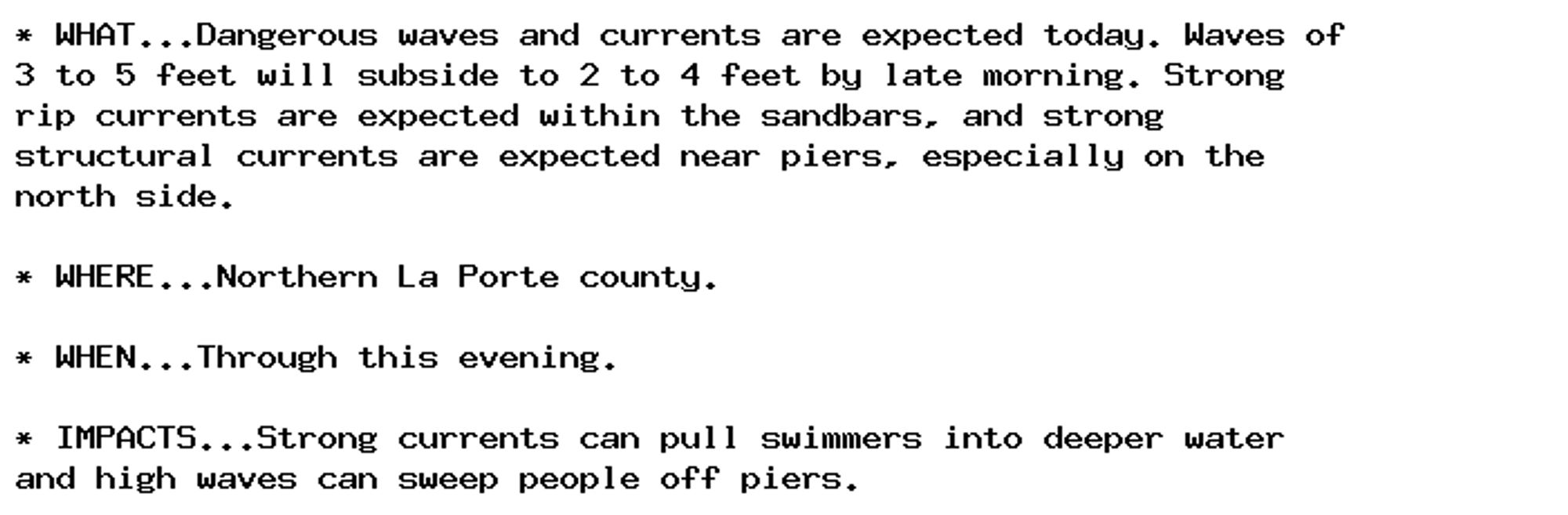
Special Weather Statement issued October 1 at 1:05AM EDT by NWS Northern Indiana Additional Details Here.

Clearing skies over portions of the area has allowed patchy dense
fog to form rapidly where skies have cleared. Dense fog is likely
to become more widespread the rest of the night, especially where
skies have cleared or where there are breaks in the clouds.

A Dense Fog Advisory may be needed later tonight. If you are
traveling overnight, be ready for rapid visibility drops.
Conditions should improve by 9 AM EDT.
0
AFiwx.nws-bot.us

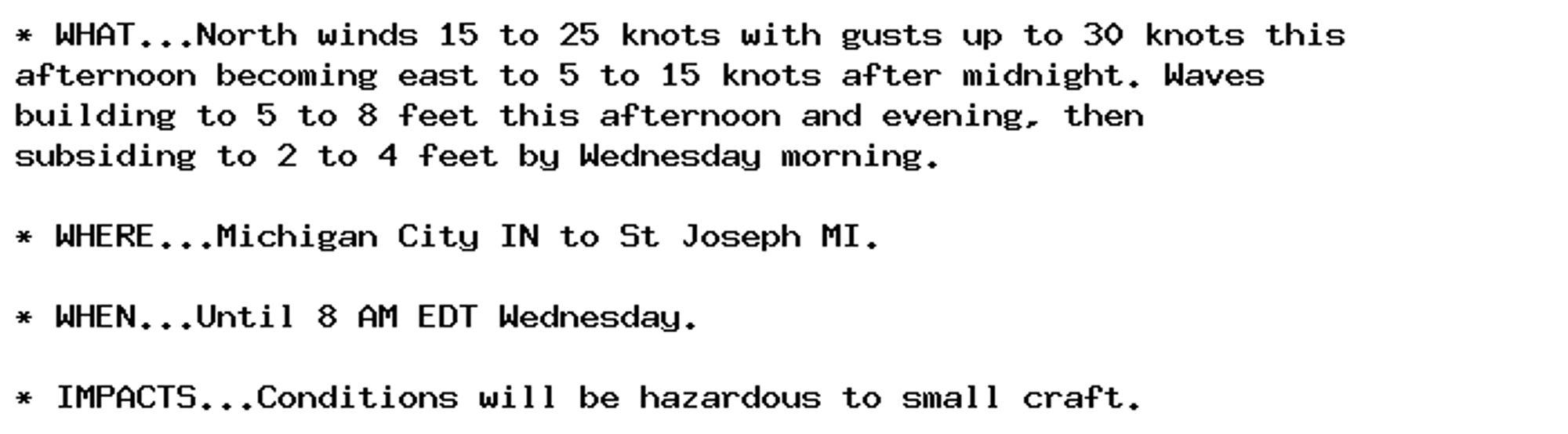
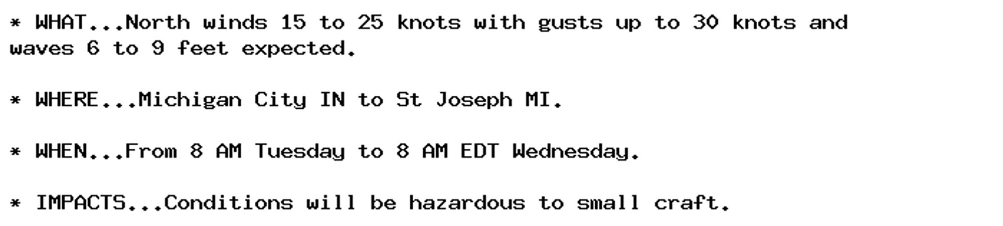
Small Craft Advisory issued September 30 at 10:20PM EDT until October 2 at 8:00AM EDT by NWS Northern Indiana Additional Details Here.

* WHAT...North to northwest winds 15 to 25 knots with gusts up to
30 knots and waves 6 to 9 feet expected.

* WHERE...Michigan City IN to St Joseph MI.

* WHEN...From 8 AM Tuesday to 8 AM EDT Wednesday.

* IMPACTS...Conditions will be hazardous to small craft.
0
AFiwx.nws-bot.us

Small Craft Advisory issued September 30 at 4:26PM EDT until October 2 at 8:00AM EDT by NWS Northern Indiana Additional Details Here.

* WHAT...North winds 15 to 25 knots with gusts up to 30 knots and
waves 6 to 9 feet expected.

* WHERE...Michigan City IN to St Joseph MI.

* WHEN...From 8 AM Tuesday to 8 AM EDT Wednesday.

* IMPACTS...Conditions will be hazardous to small craft.
0
AFiwx.nws-bot.us

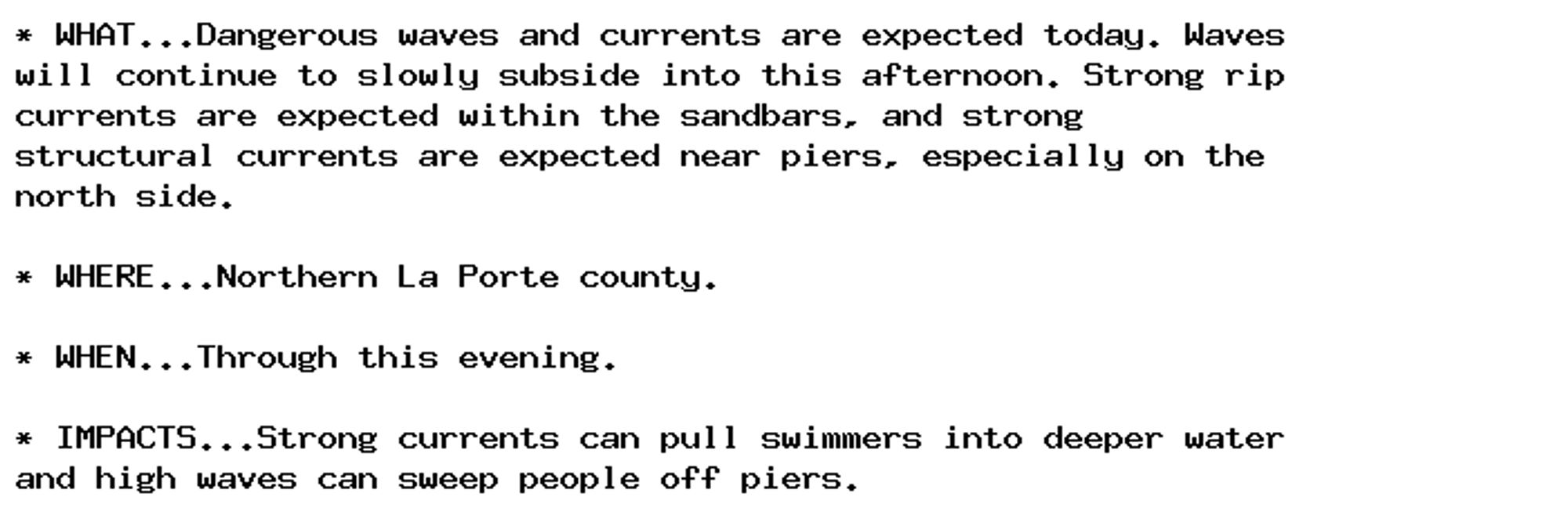
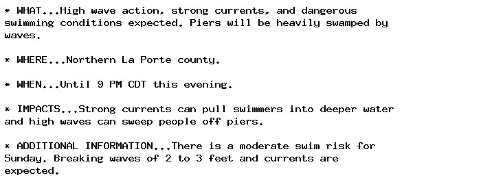
Beach Hazards Statement issued September 29 at 10:58AM EDT until September 29 at 8:00PM EDT by NWS Northern Indiana Additional Details Here.

* WHAT...Dangerous waves and currents are expected today. Waves
will continue to slowly subside into this afternoon. Strong rip
currents are expected within the sandbars, and strong
structural currents are expected near piers, especially on the
north side.

* WHERE...Northern La Porte county.

* WHEN...Through this evening.

* IMPACTS...Strong currents can pull swimmers into deeper water
and high waves can sweep people off piers.
0
AFiwx.nws-bot.us

Beach Hazards Statement issued September 29 at 4:38AM EDT until September 29 at 8:00PM EDT by NWS Northern Indiana Additional Details Here.

* WHAT...Dangerous waves and currents are expected today. Waves of
3 to 5 feet will subside to 2 to 4 feet by late morning. Strong
rip currents are expected within the sandbars, and strong
structural currents are expected near piers, especially on the
north side.

* WHERE...Northern La Porte county.

* WHEN...Through this evening.

* IMPACTS...Strong currents can pull swimmers into deeper water
and high waves can sweep people off piers.
0
AFiwx.nws-bot.us

🚨 Beach Hazards Statement issued September 28 at 3:41PM EDT until September 28 at 10:00PM EDT by NWS Northern Indiana 🚨 Additional Details Here.

* WHAT...High wave action, strong currents, and dangerous
swimming conditions expected. Piers will be heavily swamped by
waves.

* WHERE...Northern La Porte county.

* WHEN...Until 9 PM CDT this evening.

* IMPACTS...Strong currents can pull swimmers into deeper water
and high waves can sweep people off piers.

* ADDITIONAL INFORMATION...There is a moderate swim risk for
Sunday. Breaking waves of 2 to 3 feet and currents are
expected.
0
AFiwx.nws-bot.us

🚨 Small Craft Advisory issued September 28 at 3:41PM EDT until September 28 at 10:00PM EDT by NWS Northern Indiana 🚨 Additional Details Here.

* WHAT...Northeast winds 15 to 25 knots. Waves 3 to 5 feet.

* WHERE...Michigan City IN to New Buffalo MI.

* WHEN...Until 10 PM EDT this evening.

* IMPACTS...Conditions will be hazardous to small craft.
0
AF
Alerts from NWS Northern Indiana (UNOFFICIAL)
@iwx.nws-bot.us
Unofficial bot sharing alerts from NWS Northern Indiana. This account is not monitored. Contact @wandrme.paxex.aero if needed.
122 followers1 following16 posts