BLUE
Profile banner
JB
Jonathan Bohan
@jonathanbohan.bsky.social
Data Librarian and wannabe Historian. Reader. Baseball fan. 2006 Time Magazine Person of the Year.
77 followers223 following345 posts
JBjonathanbohan.bsky.social

Iglasi-YES

0
JBjonathanbohan.bsky.social

Had a friend that used to call me "Joe Nathan"

0
Reposted by Jonathan Bohan
NHnhc-atlc.nws-bot.us

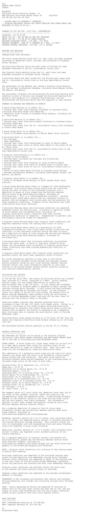
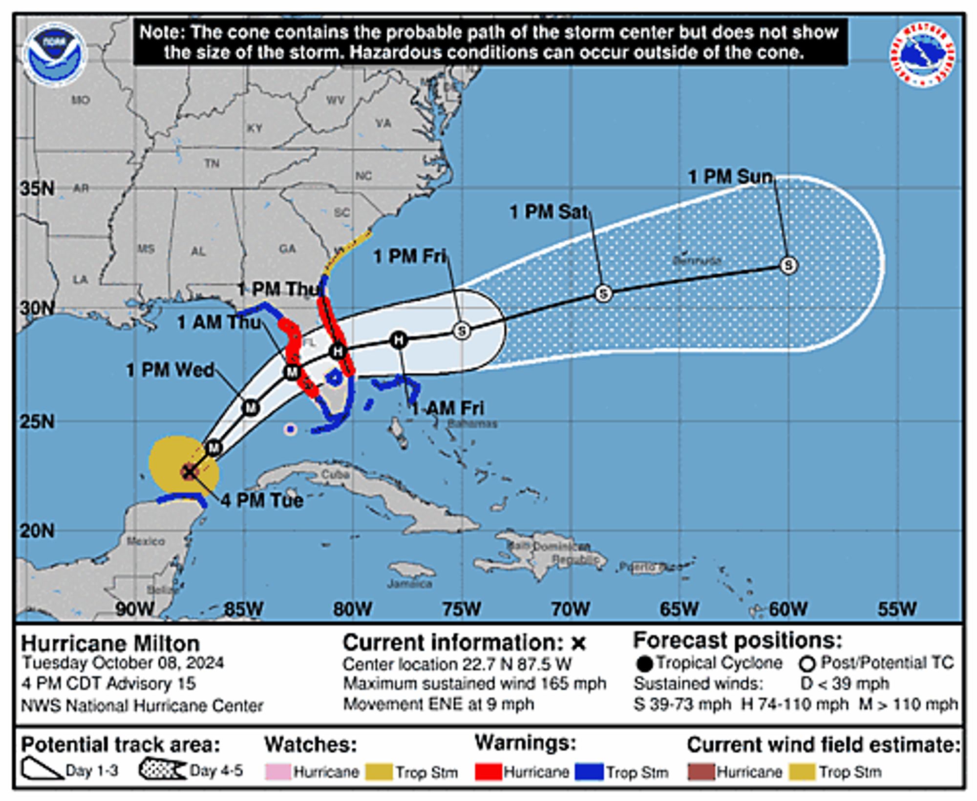
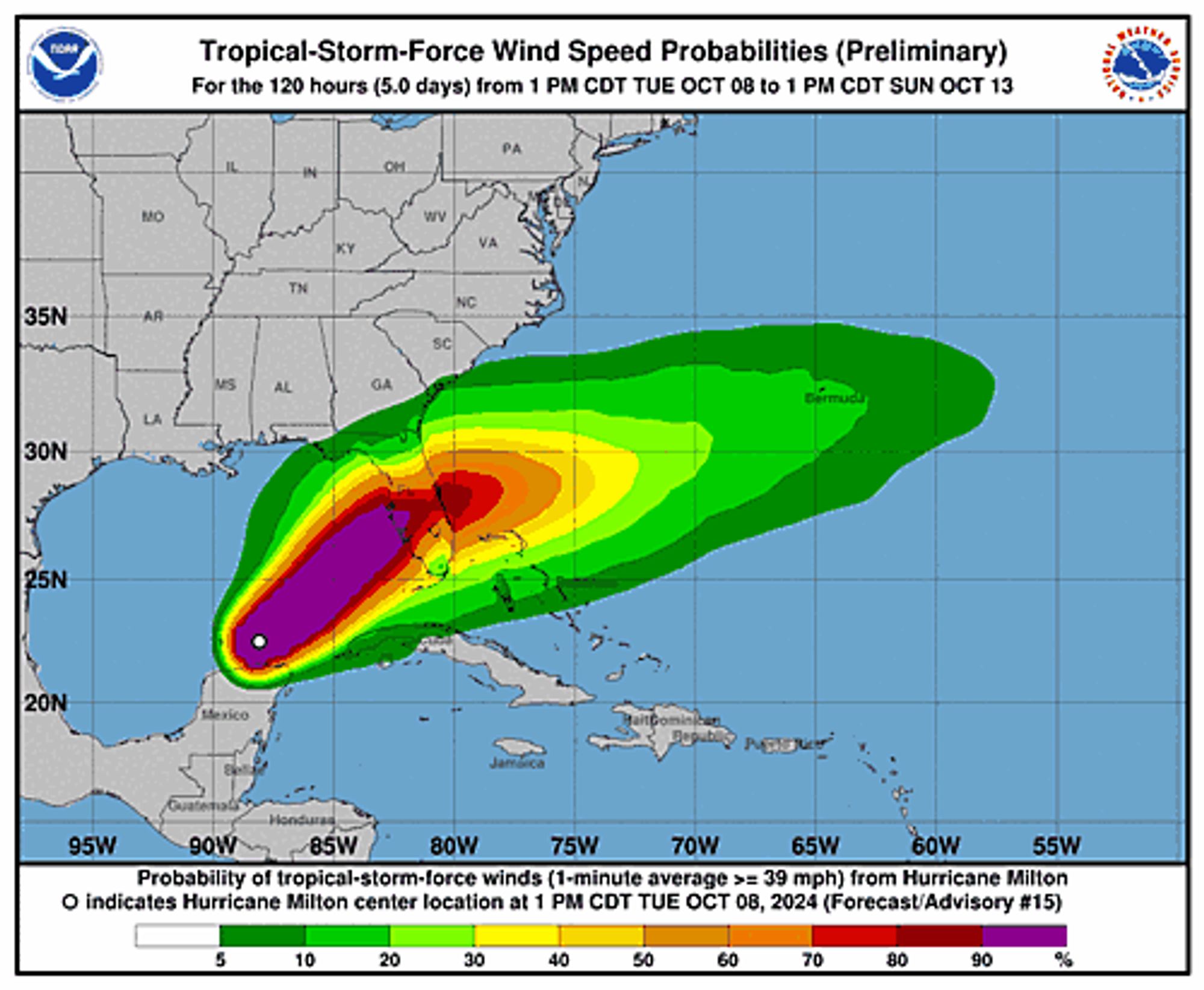
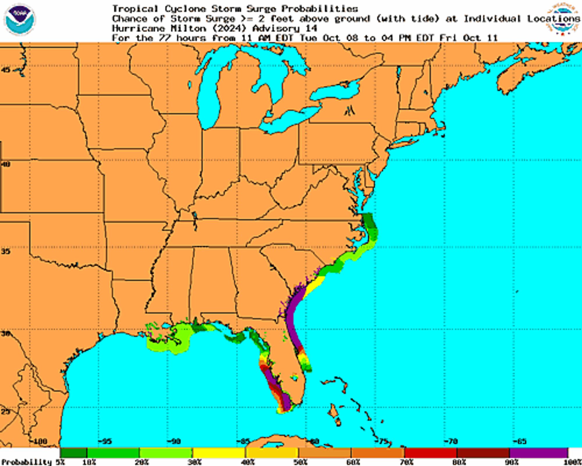
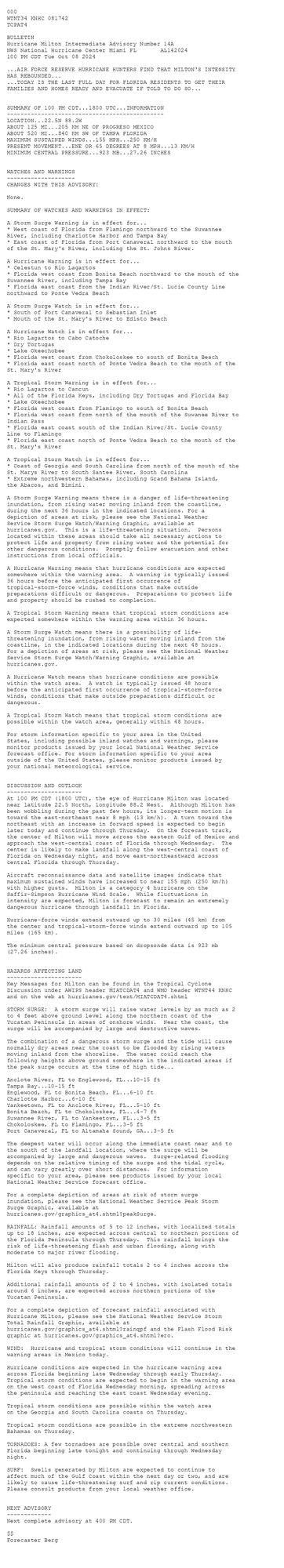
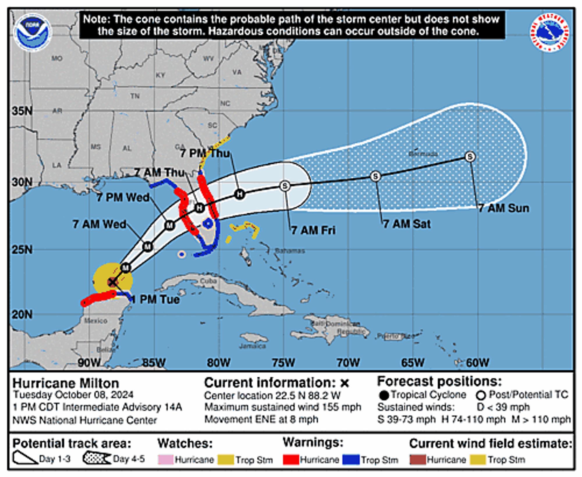
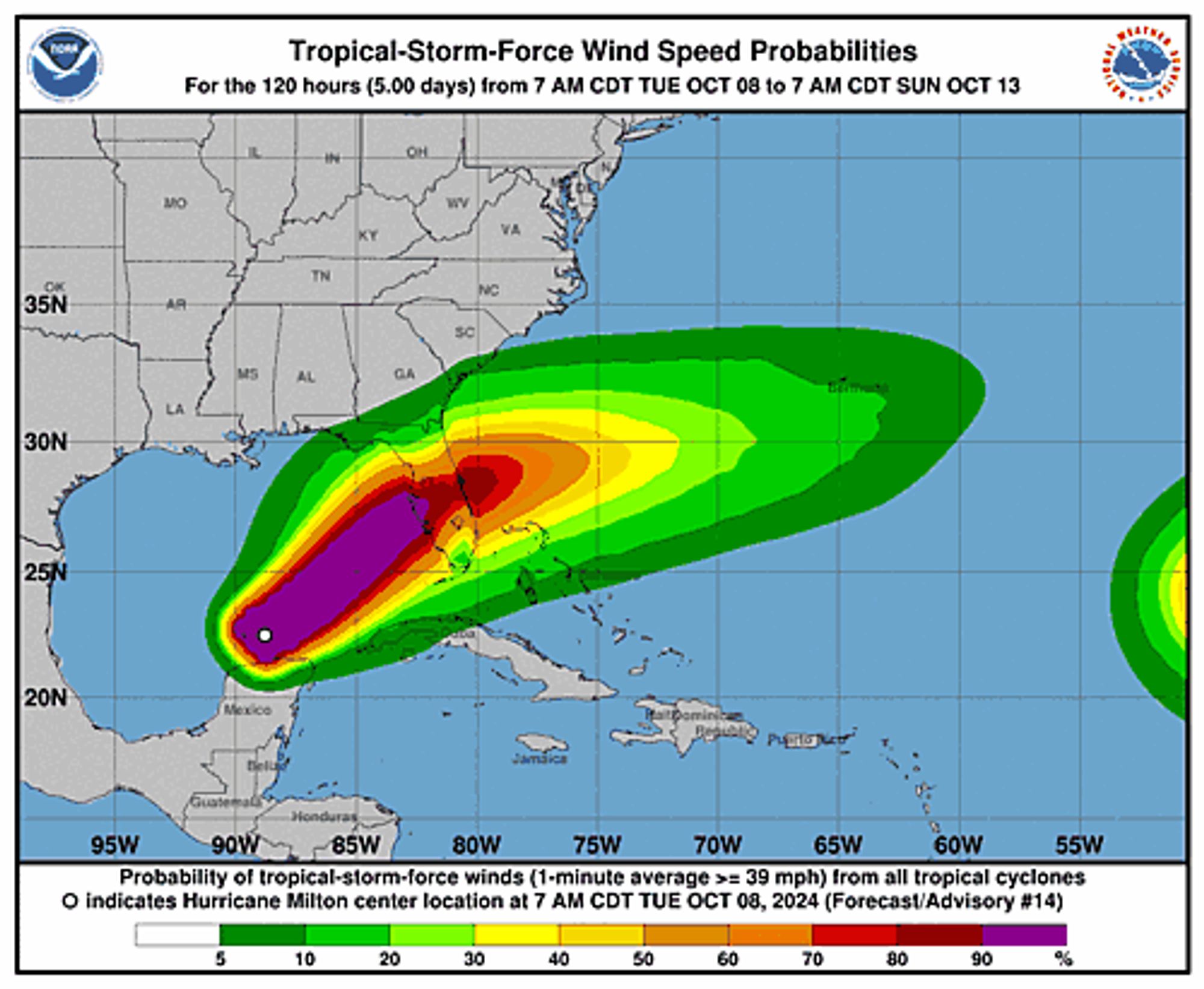
Atlantic Hurricane Milton Advisory Number 15 issued at Tue, 08 Oct 2024 20:53:48 +0000 ...MILTON BACK TO CATEGORY 5 STRENGTH... ...FLORIDA RESIDENTS SHOULD GET THEIR FAMILIES AND HOMES READY AND EVACUATE IF TOLD TO DO SO... Additional Details Here.


 <br />
 000<br />
 WTNT34 KNHC 082053<br />
 TCPAT4<br />
  <br />
 BULLETIN<br />
 Hurricane Milton Advisory Number  15<br />
 NWS National Hurricane Center Miami FL       AL142024<br />
 400 PM CDT Tue Oct 08 2024<br />
  <br />
 ...MILTON BACK TO CATEGORY 5 STRENGTH...<br />
 ...FLORIDA RESIDENTS SHOULD GET THEIR FAMILIES AND HOMES READY AND<br />
 EVACUATE IF TOLD TO DO SO...<br />
  <br />
  <br />
 SUMMARY OF 400 PM CDT...2100 UTC...INFORMATION<br />
 ----------------------------------------------<br />
 LOCATION...22.7N 87.5W<br />
 ABOUT 320 MI...520 KM WSW OF THE DRY TORTUGAS<br />
 ABOUT 480 MI...775 KM SW OF TAMPA FLORIDA<br />
 MAXIMUM SUSTAINED WINDS...165 MPH...270 KM/H<br />
 PRESENT MOVEMENT...ENE OR 75 DEGREES AT 9 MPH...15 KM/H<br />
 MINIMUM CENTRAL PRESSURE...918 MB...27.11 INCHES<br />
  <br />
  <br />
 WATCHES AND WARNINGS<br />
 --------------------<br />
 CHANGES WITH THIS ADVISORY:<br />
  <br />
 The Storm Surge Warning along the U.S. east coast has been extended<br />
 southward to Sebastian Inlet, Florida, and northward to Altamaha<br />
 Sound, Georgia.<br />
  <br />
 The Hurricane Warning along the east coast of Florida has been<br />
 extended southward to the St. Lucie/Martin County Line.<br />
  <br />
 The Tropical Storm Warning along the U.S. east coast has been<br />
 extended northward to Altamaha Sound, Georgia.<br />
  <br />
 A Hurricane Watch has been issued for the Florida east coast from<br />
 the St. Lucie/Martin County Line to the Palm Beach/Martin County<br />
 Line.<br />
  <br />
 The government of the Bahamas has issued a Tropical Storm Warning<br />
 for the extreme northwestern Bahamas, including Grand Bahama Island,<br />
 the Abacos, and Bimini.<br />
  <br />
 The government of Mexico has discontinued the Hurricane Warning from<br />
 Celestun to west of Dzilam, has changed the Hurricane Warning from<br />
 Dzilam to Rio Lagartos to a Tropical Storm Warning, and has<br />
 discontinued the Hurricane Watch from Rio Lagartos to Cabo Catoche.<br />
  <br />
 SUMMARY OF WATCHES AND WARNINGS IN EFFECT:<br />
  <br />
 A Storm Surge Warning is in effect for...<br />
 * Florida west coast from Flamingo northward to Suwannee River,<br />
 including Charlotte Harbor and Tampa Bay<br />
 * Sebastian Inlet Florida to Altamaha Sound Georgia, including the<br />
 St. Johns River<br />
  <br />
 A Hurricane Warning is in effect for...<br />
 * Florida west coast from Bonita Beach northward to Suwannee River,<br />
 including Tampa Bay<br />
 * Florida east coast from the St. Lucie/Martin County Line northward<br />
 to Ponte Vedra Beach<br />
  <br />
 A Storm Surge Watch is in effect for...<br />
 * North of Altamaha Sound Georgia to Edisto Beach South Carolina<br />
  <br />
 A Hurricane Watch is in effect for...<br />
 * Dry Tortugas<br />
 * Lake Okeechobee<br />
 * Florida west coast from Chokoloskee to south of Bonita Beach<br />
 * Florida east coast north of Ponte Vedra Beach to the mouth of the<br />
 St. Marys River<br />
 * Florida east coast from the St. Lucie/Martin County Line to the<br />
 Palm Beach/Martin County Line<br />
  <br />
 A Tropical Storm Warning is in effect for...<br />
 * Dzilam to Cancun Mexico<br />
 * Florida Keys, including Dry Tortugas and Florida Bay<br />
 * Lake Okeechobee<br />
 * Florida west coast from Flamingo to south of Bonita Beach<br />
 * Florida west coast from north of Suwanee River to Indian Pass<br />
 * Florida east coast south of the St. Lucie/Martin County Line to<br />
 Flamingo<br />
 * North of Ponte Vedra Beach Florida to Altamaha Sound Georgia<br />
 * Extreme northwestern Bahamas, including Grand Bahama Island, the<br />
 Abacos, and Bimini<br />
  <br />
 A Tropical Storm Watch is in effect for...<br />
 * North of Altamaha Sound Georgia to South Santee River South<br />
 Carolina<br />
  <br />
 A Storm Surge Warning means there is a danger of life-threatening<br />
 inundation, from rising water moving inland from the coastline,<br />
 during the next 36 hours in the indicated locations. For a<br />
 depiction of areas at risk, please see the National Weather<br />
 Service Storm Surge Watch/Warning Graphic, available at<br />
 hurricanes.gov.  This is a life-threatening situation.  Persons<br />
 located within these areas should take all necessary actions to<br />
 protect life and property from rising water and the potential for<br />
 other dangerous conditions.  Promptly follow evacuation and other<br />
 instructions from local officials.<br />
  <br />
 A Hurricane Warning means that hurricane conditions are expected<br />
 somewhere within the warning area.  A warning is typically issued<br />
 36 hours before the anticipated first occurrence of<br />
 tropical-storm-force winds, conditions that make outside<br />
 preparations difficult or dangerous.  Preparations to protect life<br />
 and property should be rushed to completion.<br />
  <br />
 A Tropical Storm Warning means that tropical storm conditions are<br />
 expected somewhere within the warning area within 36 hours.<br />
  <br />
 A Storm Surge Watch means there is a possibility of life-<br />
 threatening inundation, from rising water moving inland from the<br />
 coastline, in the indicated locations during the next 48 hours.<br />
 For a depiction of areas at risk, please see the National Weather<br />
 Service Storm Surge Watch/Warning Graphic, available at<br />
 hurricanes.gov.<br />
  <br />
 A Hurricane Watch means that hurricane conditions are possible<br />
 within the watch area.  A watch is typically issued 48 hours<br />
 before the anticipated first occurrence of tropical-storm-force<br />
 winds, conditions that make outside preparations difficult or<br />
 dangerous.<br />
  <br />
 A Tropical Storm Watch means that tropical storm conditions are<br />
 possible within the watch area, generally within 48 hours.<br />
  <br />
 For storm information specific to your area in the United<br />
 States, including possible inland watches and warnings, please<br />
 monitor products issued by your local National Weather Service<br />
 forecast office. For storm information specific to your area<br />
 outside of the United States, please monitor products issued by<br />
 your national meteorological service.<br />
  <br />
  <br />
 DISCUSSION AND OUTLOOK<br />
 ----------------------<br />
 At 400 PM CDT (2100 UTC), the center of Hurricane Milton was located<br />
 near latitude 22.7 North, longitude 87.5 West.  Milton wobbled<br />
 earlier today, but the longer-term motion is toward the<br />
 east-northeast near 9 mph (15 km/h).  A turn toward the northeast<br />
 with an increase in forward speed is expected to begin tonight and<br />
 continue through early Thursday.  A turn toward the east-northeast<br />
 and east is expected on Thursday and Friday.  On the forecast<br />
 track, the center of Milton will move across the eastern Gulf of<br />
 Mexico through Wednesday, make landfall along the west-central<br />
 coast of Florida Wednesday night, and move off the east coast of<br />
 Florida over the Atlantic Ocean on Thursday.<br />
  <br />
 Satellite images indicate that maximum sustained winds have<br />
 increased to near 165 mph (270 km/h) with higher gusts.  Milton is a<br />
 category 5 hurricane on the Saffir-Simpson Hurricane Wind Scale.<br />
 Fluctuations in intensity are likely while Milton moves across the<br />
 eastern Gulf of Mexico, but Milton is expected to be a dangerous<br />
 major hurricane when it reaches the west-central coast of Florida<br />
 Wednesday night.<br />
  <br />
 Hurricane-force winds extend outward up to 30 miles (45 km) from the<br />
 center and tropical-storm-force winds extend outward up to 140 miles<br />
 (220 km).<br />
  <br />
 The estimated minimum central pressure is 918 mb (27.11 inches).<br />
  <br />
  <br />
 HAZARDS AFFECTING LAND<br />
 ----------------------<br />
 Key Messages for Milton can be found in the Tropical Cyclone<br />
 Discussion under AWIPS header MIATCDAT4 and WMO header WTNT44 KNHC<br />
 and on the web at hurricanes.gov/text/MIATCDAT4.shtml<br />
  <br />
 STORM SURGE:  A storm surge will raise water levels by as much as 2<br />
 to 4 feet above ground level along the northern coast of the<br />
 Yucatan Peninsula in areas of onshore winds.  Near the coast, the<br />
 surge will be accompanied by large and destructive waves.<br />
  <br />
 The combination of a dangerous storm surge and the tide will cause<br />
 normally dry areas near the coast to be flooded by rising waters<br />
 moving inland from the shoreline.  The water could reach the<br />
 following heights above ground somewhere in the indicated areas if<br />
 the peak surge occurs at the time of high tide...<br />
  <br />
 Anclote River, FL to Englewood, FL...10-15 ft<br />
 Tampa Bay...10-15 ft<br />
 Englewood, FL to Bonita Beach, FL...8-12 ft<br />
 Charlotte Harbor...8-12 ft<br />
 Chassahowitzka, FL to Anclote River, FL...5-10 ft<br />
 Bonita Beach, FL to Chokoloskee, FL...5-8 ft<br />
 Chokoloskee, FL to Flamingo, FL...3-5 ft<br />
 Yankeetown, FL to Chassahowitzka, FL...3-5 ft<br />
 Sebastian Inlet, FL to Altamaha Sound, GA...3-5 ft<br />
 Altamaha Sound, GA to Edisto Beach, SC...2-4 ft<br />
 Suwannee River, FL to Yankeetown, FL...2-4 ft<br />
 Dry Tortugas...2-4 ft<br />
 St. Johns River...2-4 ft<br />
  <br />
 The deepest water will occur along the immediate coast near and to<br />
 the south of the landfall location, where the surge will be<br />
 accompanied by large and dangerous waves.  Surge-related flooding<br />
 depends on the relative timing of the surge and the tidal cycle,<br />
 and can vary greatly over short distances.  For information<br />
 specific to your area, please see products issued by your local<br />
 National Weather Service forecast office.<br />
  <br />
 For a complete depiction of areas at risk of storm surge<br />
 inundation, please see the National Weather Service Peak Storm<br />
 Surge Graphic, available at<br />
 hurricanes.gov/graphics_at4.shtml?peakSurge.<br />
  <br />
 RAINFALL: Rainfall amounts of 6 to 12 inches, with localized totals<br />
 up to 18 inches, are expected across central to northern portions of<br />
 the Florida Peninsula through Thursday.  This rainfall brings the<br />
 risk of catastrophic and life-threatening flash and urban flooding,<br />
 along with moderate to major river flooding.<br />
  <br />
 Additional rainfall amounts of  2 to 4 inches, with isolated totals<br />
 around 6 inches, are expected across northern portions of the<br />
 Yucatan Peninsula.<br />
  <br />
 For a complete depiction of forecast rainfall associated with<br />
 Hurricane Milton, please see the National Weather Service Storm<br />
 Total Rainfall Graphic, available at<br />
 hurricanes.gov/graphics_at4.shtml?rainqpf and the Flash Flood Risk<br />
 graphic at hurricanes.gov/graphics_at4.shtml?ero.<br />
  <br />
 WIND:  Tropical storm conditions will continue in the warning areas<br />
 in Mexico this evening.<br />
  <br />
 Hurricane conditions are expected in the hurricane warning area<br />
 across Florida beginning late Wednesday through early Thursday.<br />
 Tropical storm conditions are expected to begin in the warning area<br />
 on the west coast of Florida around midday Wednesday, spreading<br />
 across the peninsula and reaching the east coast Wednesday evening.<br />
  <br />
 Tropical storm conditions are possible within the watch area<br />
 on the Georgia and South Carolina coasts on Thursday.<br />
  <br />
 Tropical storm conditions are expected in the extreme northwestern<br />
 Bahamas on Thursday.<br />
  <br />
 TORNADOES: A few tornadoes are possible over central and southern<br />
 Florida beginning late tonight and continuing through early Thursday<br />
 morning.<br />
  <br />
 SURF:  Swells generated by Milton are expected to continue to<br />
 affect much of the Gulf Coast within the next day or two, and are<br />
 likely to cause life-threatening surf and rip current conditions.<br />
 Please consult products from your local weather office.<br />
  <br />
  <br />
 NEXT ADVISORY<br />
 -------------<br />
 Next intermediate advisory at 700 PM CDT.<br />
 Next complete advisory at 1000 PM CDT.<br />
  <br />
 $$<br />
 Forecaster Berg<br />
  <br />
Hurricane Milton 5-Day Uncertainty Track Image
Hurricane Milton 34-Knot Wind Speed Probabilities
Hurricane Milton Probabilistic Storm Surge Graphics Image
1
JBjonathanbohan.bsky.social

The man can WRITE

0
JBjonathanbohan.bsky.social

I did but I got the flu shot and shingles vaccine at the same time, was meh for a day.

0
JBjonathanbohan.bsky.social

Holy moly

0
JBjonathanbohan.bsky.social

YES

0
Profile banner
JB
Jonathan Bohan
@jonathanbohan.bsky.social
Data Librarian and wannabe Historian. Reader. Baseball fan. 2006 Time Magazine Person of the Year.
77 followers223 following345 posts