BLUE
AF
Alerts from NWS Lake Charles LA (UNOFFICIAL)
@lch.nws-bot.us
Unofficial bot sharing alerts from NWS Lake Charles LA. This account is not monitored. Contact @wandrme.paxex.aero if needed.
94 followers1 following25 posts
AFlch.nws-bot.us

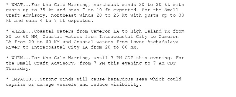
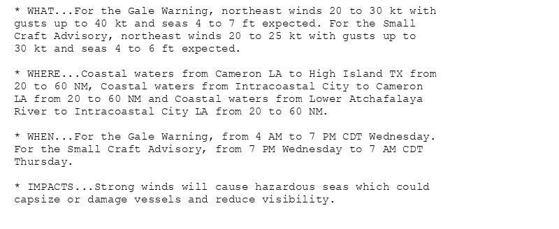
Gale Warning issued October 16 at 3:05AM CDT until October 16 at 7:00PM CDT by NWS Lake Charles LA Additional Details Here.(1/2)

* WHAT...For the Gale Warning, northeast winds 20 to 30 kt with
gusts up to 35 kt and seas 7 to 10 ft expected. For the Small
Craft Advisory, northeast winds 20 to 25 kt with gusts up to 30
kt and seas 4 to 7 ft expected.

* WHERE...Coastal waters from Cameron LA to High Island TX from
20 to 60 NM, Coastal waters from Intracoastal City to Cameron
LA from 20 to 60 NM and Coastal waters from Lower Atchafalaya
River to Intracoastal City LA from 20 to 60 NM.

* WHEN...For the Gale Warning, until 7 PM CDT this evening. For
the Small Craft Advisory, from 7 PM this evening to 7 AM CDT
Thursday.

* IMPACTS...Strong winds will cause hazardous seas which could
capsize or damage vessels and reduce visibility.
* WHAT...Northeast winds 15 to 25 kt with gusts up to 30 kt.

* WHERE...Sabine Lake, Calcasieu Lake, Vermilion and West Cote
Blanche Bays and Atchafalaya and East Cote Blanche Bays.

* WHEN...Until 7 PM CDT this evening.

* IMPACTS...Conditions will be hazardous to small craft.
* WHAT...Northeast winds 20 to 30 kt with gusts up to 35 kt and
seas 4 to 6 ft.

* WHERE...Coastal waters from Cameron LA to High Island TX out
20 NM, Coastal waters from Intracoastal City to Cameron LA out
20 NM and Coastal waters from Lower Atchafalaya River to
Intracoastal City LA out 20 NM.

* WHEN...Until 7 AM CDT Thursday.

* IMPACTS...Conditions will be hazardous to small craft.
0
AFlch.nws-bot.us

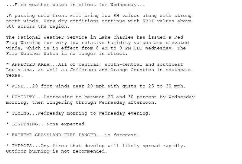
🚨 Red Flag Warning issued October 16 at 3:04AM CDT until October 16 at 9:00PM CDT by NWS Lake Charles LA 🚨 Additional Details Here.

...Fire weather watch in effect for Wednesday...

.A passing cold front will bring low RH values along with strong
northeast winds. Very dry conditions continue with KBDI values
above 600 across the region.

* AFFECTED AREA...Vernon, Rapides, Avoyelles, Beauregard, Allen,
Evangeline, St. Landry, Lafayette, Upper St. Martin, Lower St.
Martin, West Cameron, East Cameron, Northern Calcasieu,
Northern Jefferson Davis, Northern Acadia, Upper Vermilion,
Upper Iberia, Upper St. Mary, Southern Calcasieu, Southern
Jefferson Davis, Southern Acadia, Lower Vermilion, Lower
Iberia, Lower St. Mary, Upper Jefferson, Northern Orange,
Lower Jefferson and Southern Orange.

* WIND...20 foot winds near 20 mph with gusts to 25 to 30 mph.

* HUMIDITY...Decreasing to between 20 and 30 percent by
Wednesday morning, then lingering through Wednesday afternoon.

* TIMING...Wednesday morning to Wednesday evening.

* LIGHTNING...None expected.

* EXTREME GRASSLAND FIRE DANGER...is forecast.

* IMPACTS...Any fires that develop will likely spread rapidly.
Outdoor burning is not recommended.
...Fire weather watch in effect for Wednesday...

.A passing cold front will bring low RH values along with strong
northeast winds. Very dry conditions continue with KBDI values
above 600 across the region.

* AFFECTED AREA...Tyler, Hardin, Northern Jasper, Northern
Newton, Southern Jasper and Southern Newton.

* WIND...20 foot winds of 15 to 20 mph with gusts up to 25 mph.

* HUMIDITY...Decreasing to between 25 and 30 percent by
Wednesday morning, then lingering through Wednesday afternoon.

* TIMING...Wednesday morning to Wednesday evening.

* EXTREME GRASSLAND FIRE DANGER...is forecast.

* IMPACTS...Any fires that develop will likely spread rapidly.
Outdoor burning is not recommended.
0
AFlch.nws-bot.us

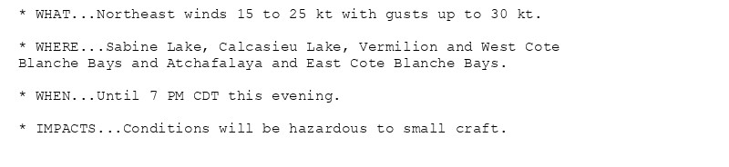
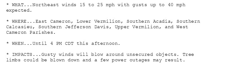
Wind Advisory issued October 16 at 2:45AM CDT until October 16 at 4:00PM CDT by NWS Lake Charles LA Additional Details Here.

* WHAT...Northeast winds 15 to 25 mph with gusts up to 40 mph
expected.

* WHERE...East Cameron, Lower Vermilion, Southern Acadia, Southern
Calcasieu, Southern Jefferson Davis, Upper Vermilion, and West
Cameron Parishes.

* WHEN...Until 4 PM CDT this afternoon.

* IMPACTS...Gusty winds will blow around unsecured objects. Tree
limbs could be blown down and a few power outages may result.
0
AFlch.nws-bot.us

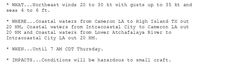
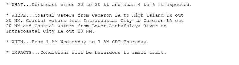
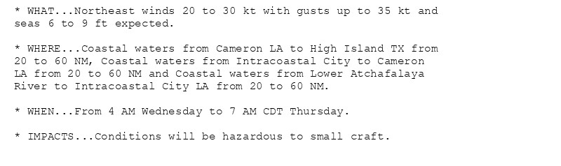
Small Craft Advisory issued October 15 at 2:25PM CDT until October 17 at 7:00AM CDT by NWS Lake Charles LA Additional Details Here.

* WHAT...For the Gale Warning, northeast winds 20 to 30 kt with
gusts up to 40 kt and seas 4 to 7 ft expected. For the Small
Craft Advisory, northeast winds 20 to 25 kt with gusts up to
30 kt and seas 4 to 6 ft expected.

* WHERE...Coastal waters from Cameron LA to High Island TX from
20 to 60 NM, Coastal waters from Intracoastal City to Cameron
LA from 20 to 60 NM and Coastal waters from Lower Atchafalaya
River to Intracoastal City LA from 20 to 60 NM.

* WHEN...For the Gale Warning, from 4 AM to 7 PM CDT Wednesday.
For the Small Craft Advisory, from 7 PM Wednesday to 7 AM CDT
Thursday.

* IMPACTS...Strong winds will cause hazardous seas which could
capsize or damage vessels and reduce visibility.
* WHAT...Northeast winds 15 to 25 kt with gusts up to 30 kt
expected.

* WHERE...Sabine Lake, Calcasieu Lake, Vermilion and West Cote
Blanche Bays and Atchafalaya and East Cote Blanche Bays.

* WHEN...From 1 AM to 7 PM CDT Wednesday.

* IMPACTS...Conditions will be hazardous to small craft.
* WHAT...Northeast winds 20 to 30 kt and seas 4 to 6 ft expected.

* WHERE...Coastal waters from Cameron LA to High Island TX out
20 NM, Coastal waters from Intracoastal City to Cameron LA out
20 NM and Coastal waters from Lower Atchafalaya River to
Intracoastal City LA out 20 NM.

* WHEN...From 1 AM Wednesday to 7 AM CDT Thursday.

* IMPACTS...Conditions will be hazardous to small craft.
0
AFlch.nws-bot.us

🚨 Red Flag Warning issued October 15 at 2:15PM CDT until October 16 at 9:00PM CDT by NWS Lake Charles LA 🚨 Additional Details Here.

...Fire weather watch in effect for Wednesday...

.A passing cold front will bring low RH values along with strong
north winds. Very dry conditions continue with KBDI values above
600 across the region.

The National Weather Service in Lake Charles has issued a Red
Flag Warning for very low relative humidity values and elevated
winds, which is in effect from 8 AM to 9 PM CDT Wednesday. The
Fire Weather Watch is no longer in effect.

* AFFECTED AREA...All of central, south-central and southwest
Louisiana, as well as Jefferson and Orange Counties in southeast
Texas.

* WIND...20 foot winds near 20 mph with gusts to 25 to 30 mph.

* HUMIDITY...Decreasing to between 20 and 30 percent by Wednesday
morning, then lingering through Wednesday afternoon.

* TIMING...Wednesday morning to Wednesday evening.

* LIGHTNING...None expected.

* EXTREME GRASSLAND FIRE DANGER...is forecast.

* IMPACTS...Any fires that develop will likely spread rapidly.
Outdoor burning is not recommended.
...Fire weather watch in effect for Wednesday...

.A passing cold front will bring low RH values along with strong
north winds. Very dry conditions continue with KBDI values above
600 across the region.

* AFFECTED AREA...Tyler, Hardin, Jasper and Newton Counties in
southeast Texas.

* WIND...20 foot winds of 15 to 20 mph with gusts up to 25 mph.

* HUMIDITY...Decreasing to between 25 and 30 percent by Wednesday
morning, then lingering through Wednesday afternoon.

* TIMING...Wednesday morning to Wednesday evening.

* EXTREME GRASSLAND FIRE DANGER...is forecast.

* IMPACTS...Any fires that develop will likely spread rapidly.
Outdoor burning is not recommended.
0
AFlch.nws-bot.us

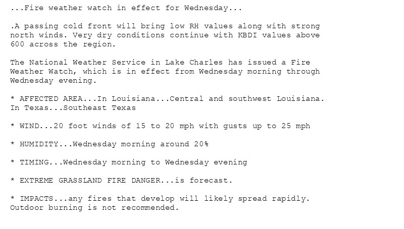
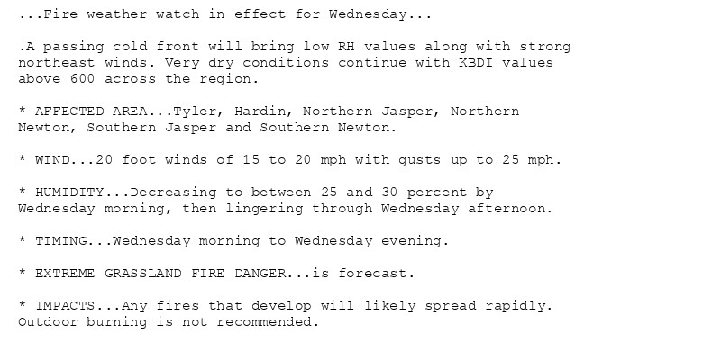
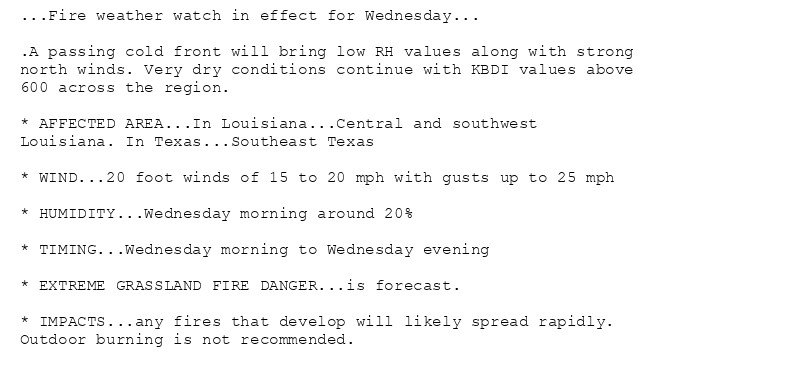
🚨 Fire Weather Watch issued October 15 at 2:59AM CDT until October 16 at 9:00PM CDT by NWS Lake Charles LA 🚨 Additional Details Here.

...Fire weather watch in effect for Wednesday...

.A passing cold front will bring low RH values along with strong
north winds. Very dry conditions continue with KBDI values above
600 across the region.

* AFFECTED AREA...Vernon, Rapides, Avoyelles, Beauregard, Allen,
Evangeline, St. Landry, Lafayette, Upper St. Martin, Lower St.
Martin, West Cameron, East Cameron, Northern Calcasieu,
Northern Jefferson Davis, Northern Acadia, Upper Vermilion,
Upper Iberia, Upper St. Mary, Tyler, Hardin, Southern
Calcasieu, Southern Jefferson Davis, Southern Acadia, Lower
Vermilion, Lower Iberia, Lower St. Mary, Northern Jasper,
Northern Newton, Southern Jasper, Southern Newton, Upper
Jefferson, Northern Orange, Lower Jefferson and Southern
Orange.

* WIND...20 foot winds of 15 to 20 mph with gusts up to 25 mph

* HUMIDITY...Wednesday morning around 20%

* TIMING...Wednesday morning to Wednesday evening

* EXTREME GRASSLAND FIRE DANGER...is forecast.

* IMPACTS...any fires that develop will likely spread rapidly.
Outdoor burning is not recommended.
0
AFlch.nws-bot.us

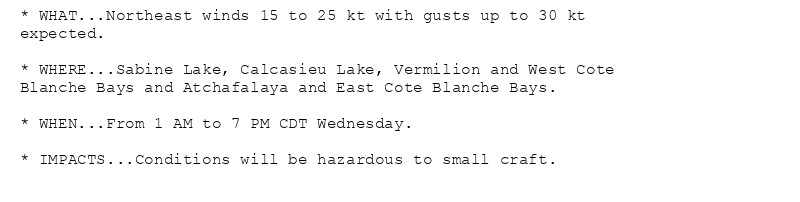
Small Craft Advisory issued October 15 at 2:58AM CDT until October 16 at 7:00PM CDT by NWS Lake Charles LA Additional Details Here.

* WHAT...Northeast winds 15 to 25 kt with gusts up to 30 kt
expected.

* WHERE...Sabine Lake, Calcasieu Lake, Vermilion and West Cote
Blanche Bays and Atchafalaya and East Cote Blanche Bays.

* WHEN...From 1 AM to 7 PM CDT Wednesday.

* IMPACTS...Conditions will be hazardous to small craft.
* WHAT...Northeast winds 20 to 30 kt and seas 4 to 6 ft expected.

* WHERE...Coastal waters from Cameron LA to High Island TX out
20 NM, Coastal waters from Intracoastal City to Cameron LA out
20 NM and Coastal waters from Lower Atchafalaya River to
Intracoastal City LA out 20 NM.

* WHEN...From 1 AM Wednesday to 7 AM CDT Thursday.

* IMPACTS...Conditions will be hazardous to small craft.
* WHAT...Northeast winds 20 to 30 kt with gusts up to 35 kt and
seas 6 to 9 ft expected.

* WHERE...Coastal waters from Cameron LA to High Island TX from
20 to 60 NM, Coastal waters from Intracoastal City to Cameron
LA from 20 to 60 NM and Coastal waters from Lower Atchafalaya
River to Intracoastal City LA from 20 to 60 NM.

* WHEN...From 4 AM Wednesday to 7 AM CDT Thursday.

* IMPACTS...Conditions will be hazardous to small craft.
0
AFlch.nws-bot.us

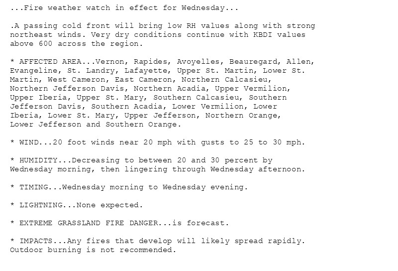
🚨 Fire Weather Watch issued October 14 at 9:53PM CDT until October 16 at 9:00PM CDT by NWS Lake Charles LA 🚨 Additional Details Here.

...Fire weather watch in effect for Wednesday...

.A passing cold front will bring low RH values along with strong
north winds. Very dry conditions continue with KBDI values above
600 across the region.

* AFFECTED AREA...In Louisiana...Central and southwest
Louisiana. In Texas...Southeast Texas

* WIND...20 foot winds of 15 to 20 mph with gusts up to 25 mph

* HUMIDITY...Wednesday morning around 20%

* TIMING...Wednesday morning to Wednesday evening

* EXTREME GRASSLAND FIRE DANGER...is forecast.

* IMPACTS...any fires that develop will likely spread rapidly.
Outdoor burning is not recommended.
0
AFlch.nws-bot.us

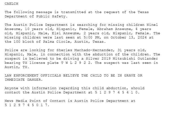
Child Abduction Emergency issued October 14 at 5:03PM CDT by NWS Lake Charles LA Additional Details Here.

CAELCH

The following message is transmitted at the request of the Texas
Department of Public Safety.

The Austin Police Department is searching for missing children Ninel
Anseume, 10 years old, Hispanic, Female, Abraham Anseume, 4 years
old, Hispanic, Male, Elsi Anseume, 2 years old, Hispanic, Female. The
missing children were last seen at 5:00 PM, on October 13, 2024 at
the 100 block of Palma Circle, Austin, Texas.

Police are looking for Sherles Machado-Hernandez, 31 years old,
Hispanic, Male, in connection with the abduction of the children. The
suspect is believed to be driving a Silver 2019 Mitsubishi Outlander
bearing TX license plate T W L 2 9 2 2. The suspect was last seen in
Austin, TX.

LAW ENFORCEMENT OFFICIALS BELIEVE THE CHILD TO BE IN GRAVE OR
IMMEDIATE DANGER.

Anyone with information regarding this child abduction, should
contact the Austin Police Department at 5 1 2 9 7 4 5 4 1 0.

News Media Point of Contact is Austin Police Department at
5 1 2 9 7 4 5 0 1 7.
0
AFlch.nws-bot.us

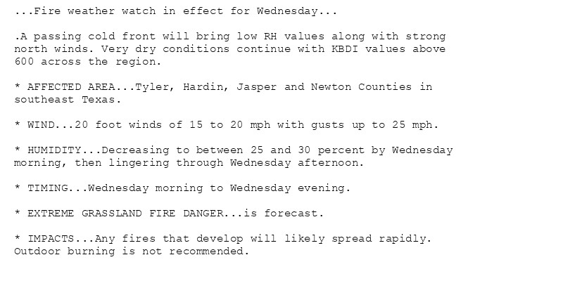
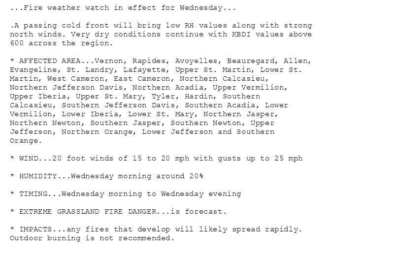
🚨 Fire Weather Watch issued October 14 at 3:23PM CDT until October 16 at 9:00PM CDT by NWS Lake Charles LA 🚨 Additional Details Here.

...Fire weather watch in effect for Wednesday...

.A passing cold front will bring low RH values along with strong
north winds. Very dry conditions continue with KBDI values above
600 across the region.

The National Weather Service in Lake Charles has issued a Fire
Weather Watch, which is in effect from Wednesday morning through
Wednesday evening.

* AFFECTED AREA...In Louisiana...Central and southwest Louisiana.
In Texas...Southeast Texas

* WIND...20 foot winds of 15 to 20 mph with gusts up to 25 mph

* HUMIDITY...Wednesday morning around 20%

* TIMING...Wednesday morning to Wednesday evening

* EXTREME GRASSLAND FIRE DANGER...is forecast.

* IMPACTS...any fires that develop will likely spread rapidly.
Outdoor burning is not recommended.
0
AF
Alerts from NWS Lake Charles LA (UNOFFICIAL)
@lch.nws-bot.us
Unofficial bot sharing alerts from NWS Lake Charles LA. This account is not monitored. Contact @wandrme.paxex.aero if needed.
94 followers1 following25 posts