BLUE
AF
Alerts from NWS Melbourne FL (UNOFFICIAL)
@mlb.nws-bot.us
Unofficial bot sharing alerts from NWS Melbourne FL. This account is not monitored. Contact @wandrme.paxex.aero if needed.
130 followers1 following173 posts
AFmlb.nws-bot.us

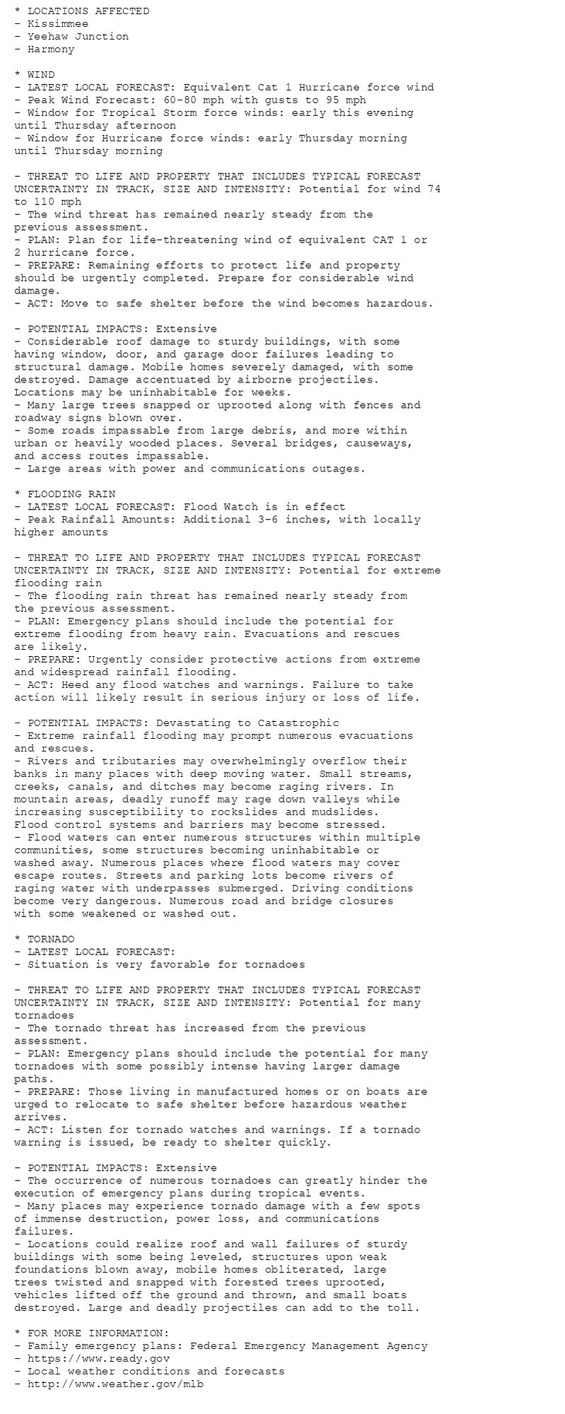
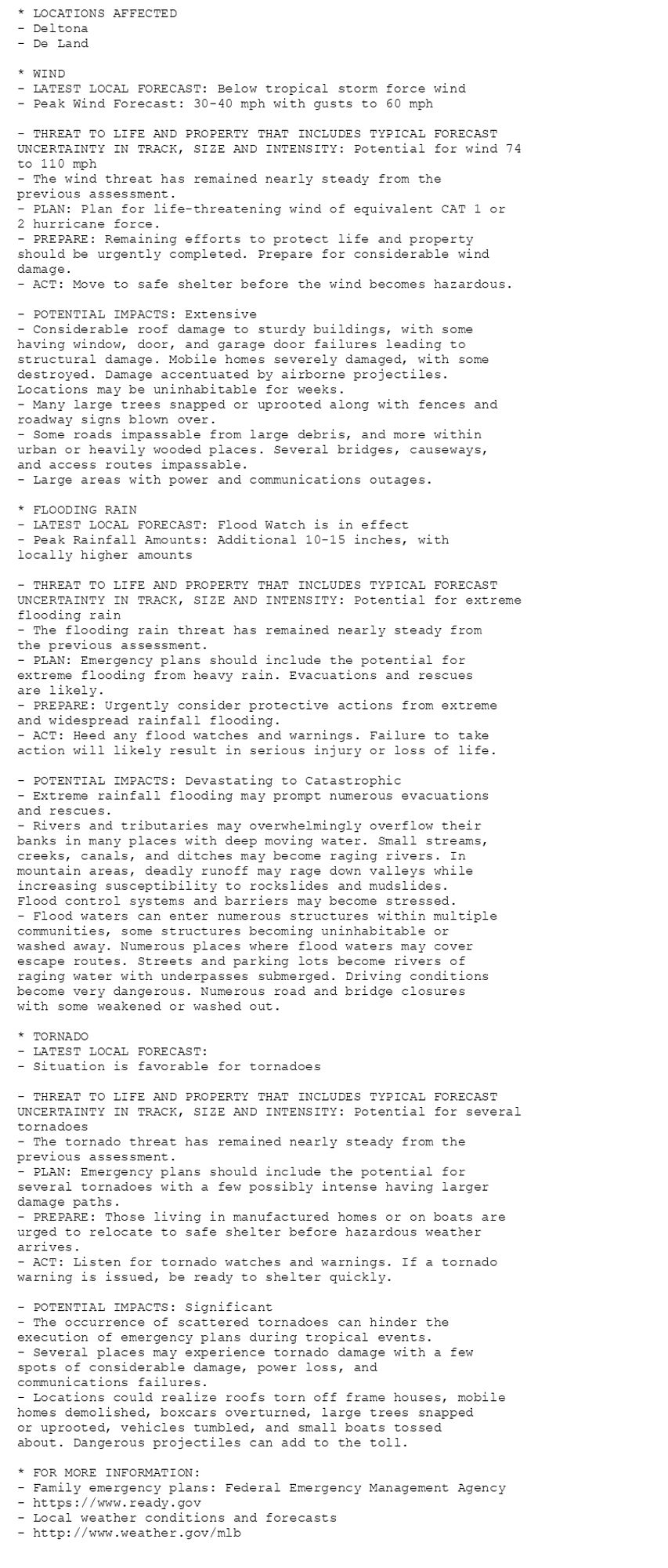
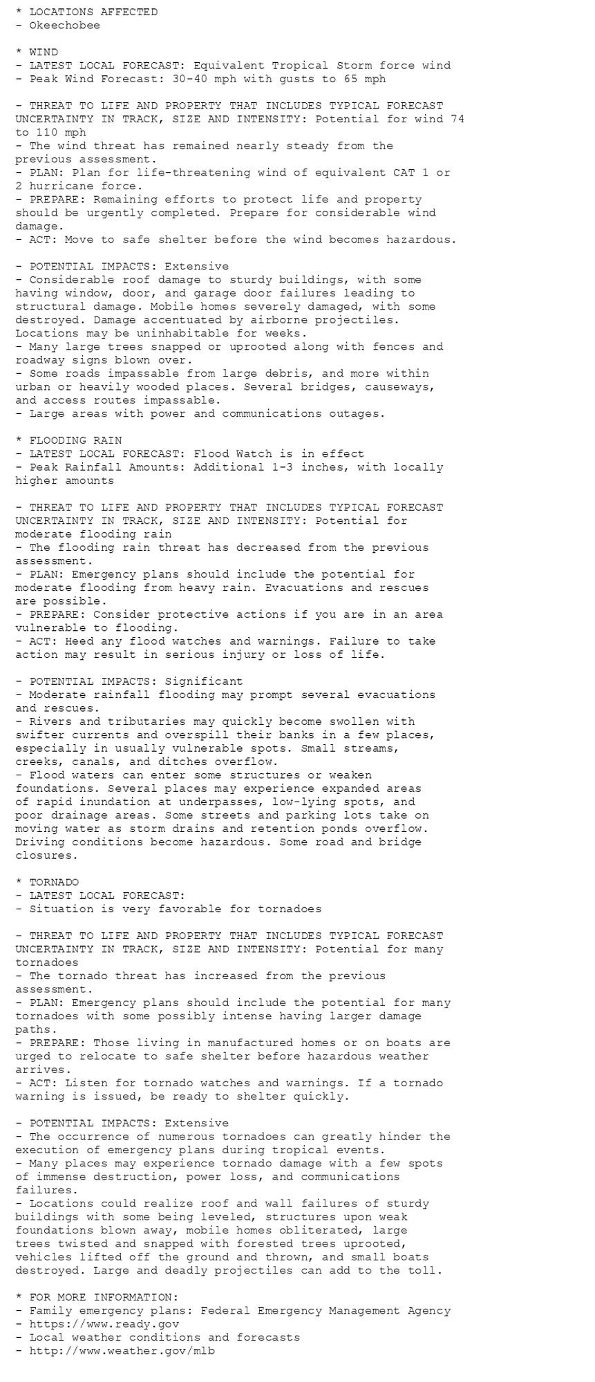
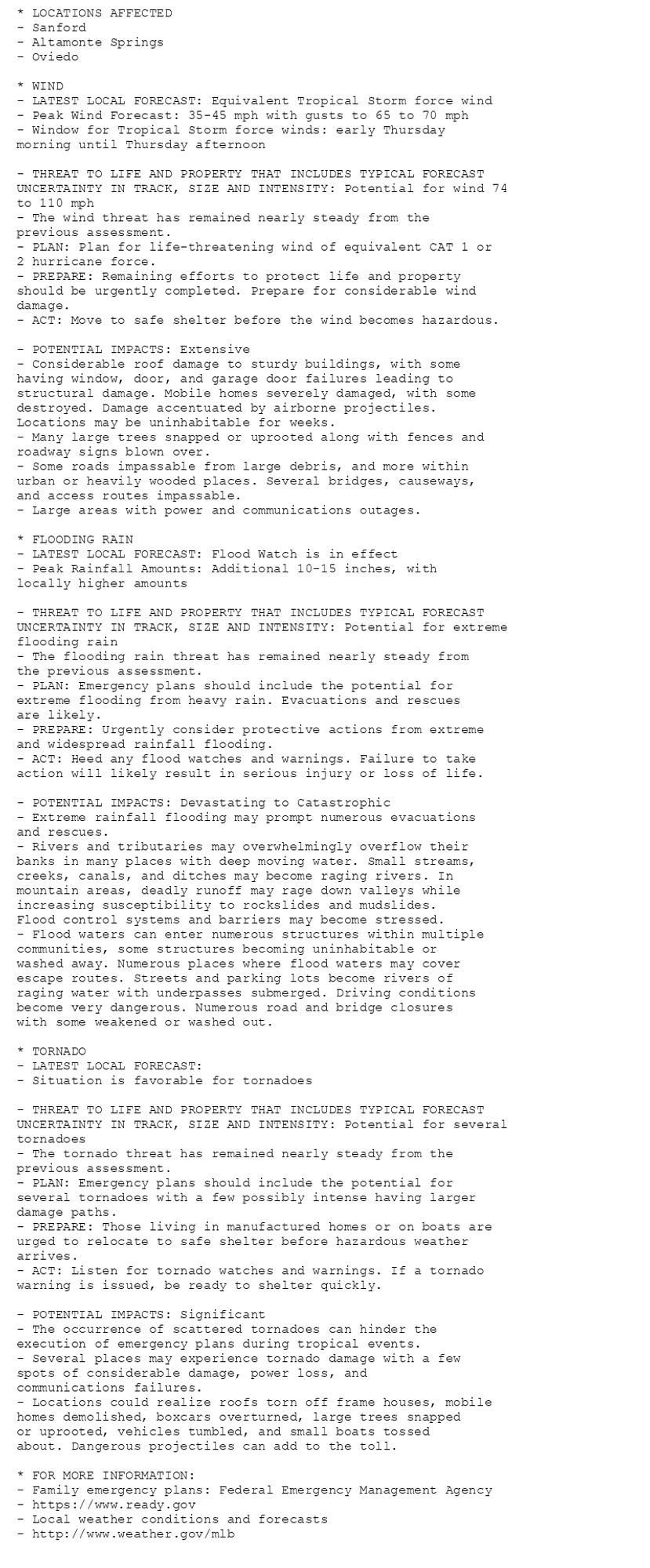
🚨🚨🚨 Hurricane Warning issued October 9 at 5:07AM EDT by NWS Melbourne FL 🚨🚨🚨 Additional Details Here. (4/7)

* LOCATIONS AFFECTED
- Kissimmee
- Yeehaw Junction
- Harmony

* WIND
- LATEST LOCAL FORECAST: Equivalent Cat 1 Hurricane force wind
- Peak Wind Forecast: 60-80 mph with gusts to 95 mph
- Window for Tropical Storm force winds: early this evening
until Thursday afternoon
- Window for Hurricane force winds: early Thursday morning
until Thursday morning

- THREAT TO LIFE AND PROPERTY THAT INCLUDES TYPICAL FORECAST
UNCERTAINTY IN TRACK, SIZE AND INTENSITY: Potential for wind 74
to 110 mph
- The wind threat has remained nearly steady from the
previous assessment.
- PLAN: Plan for life-threatening wind of equivalent CAT 1 or
2 hurricane force.
- PREPARE: Remaining efforts to protect life and property
should be urgently completed. Prepare for considerable wind
damage.
- ACT: Move to safe shelter before the wind becomes hazardous.

- POTENTIAL IMPACTS: Extensive
- Considerable roof damage to sturdy buildings, with some
having window, door, and garage door failures leading to
structural damage. Mobile homes severely damaged, with some
destroyed. Damage accentuated by airborne projectiles.
Locations may be uninhabitable for weeks.
- Many large trees snapped or uprooted along with fences and
roadway signs blown over.
- Some roads impassable from large debris, and more within
urban or heavily wooded places. Several bridges, causeways,
and access routes impassable.
- Large areas with power and communications outages.

* FLOODING RAIN
- LATEST LOCAL FORECAST: Flood Watch is in effect
- Peak Rainfall Amounts: Additional 3-6 inches, with locally
higher amounts

- THREAT TO LIFE AND PROPERTY THAT INCLUDES TYPICAL FORECAST
UNCERTAINTY IN TRACK, SIZE AND INTENSITY: Potential for extreme
flooding rain
- The flooding rain threat has remained nearly steady from
the previous assessment.
- PLAN: Emergency plans should include the potential for
extreme flooding from heavy rain. Evacuations and rescues
are likely.
- PREPARE: Urgently consider protective actions from extreme
and widespread rainfall flooding.
- ACT: Heed any flood watches and warnings. Failure to take
action will likely result in serious injury or loss of life.

- POTENTIAL IMPACTS: Devastating to Catastrophic
- Extreme rainfall flooding may prompt numerous evacuations
and rescues.
- Rivers and tributaries may overwhelmingly overflow their
banks in many places with deep moving water. Small streams,
creeks, canals, and ditches may become raging rivers. In
mountain areas, deadly runoff may rage down valleys while
increasing susceptibility to rockslides and mudslides.
Flood control systems and barriers may become stressed.
- Flood waters can enter numerous structures within multiple
communities, some structures becoming uninhabitable or
washed away. Numerous places where flood waters may cover
escape routes. Streets and parking lots become rivers of
raging water with underpasses submerged. Driving conditions
become very dangerous. Numerous road and bridge closures
with some weakened or washed out.

* TORNADO
- LATEST LOCAL FORECAST:
- Situation is very favorable for tornadoes

- THREAT TO LIFE AND PROPERTY THAT INCLUDES TYPICAL FORECAST
UNCERTAINTY IN TRACK, SIZE AND INTENSITY: Potential for many
tornadoes
- The tornado threat has increased from the previous
assessment.
- PLAN: Emergency plans should include the potential for many
tornadoes with some possibly intense having larger damage
paths.
- PREPARE: Those living in manufactured homes or on boats are
urged to relocate to safe shelter before hazardous weather
arrives.
- ACT: Listen for tornado watches and warnings. If a tornado
warning is issued, be ready to shelter quickly.

- POTENTIAL IMPACTS: Extensive
- The occurrence of numerous tornadoes can greatly hinder the
execution of emergency plans during tropical events.
- Many places may experience tornado damage with a few spots
of immense destruction, power loss, and communications
failures.
- Locations could realize roof and wall failures of sturdy
buildings with some being leveled, structures upon weak
foundations blown away, mobile homes obliterated, large
trees twisted and snapped with forested trees uprooted,
vehicles lifted off the ground and thrown, and small boats
destroyed. Large and deadly projectiles can add to the toll.

* FOR MORE INFORMATION:
- Family emergency plans: Federal Emergency Management Agency
- https://www.ready.gov
- Local weather conditions and forecasts
- http://www.weather.gov/mlb
* LOCATIONS AFFECTED
- Deltona
- De Land

* WIND
- LATEST LOCAL FORECAST: Below tropical storm force wind
- Peak Wind Forecast: 30-40 mph with gusts to 60 mph

- THREAT TO LIFE AND PROPERTY THAT INCLUDES TYPICAL FORECAST
UNCERTAINTY IN TRACK, SIZE AND INTENSITY: Potential for wind 74
to 110 mph
- The wind threat has remained nearly steady from the
previous assessment.
- PLAN: Plan for life-threatening wind of equivalent CAT 1 or
2 hurricane force.
- PREPARE: Remaining efforts to protect life and property
should be urgently completed. Prepare for considerable wind
damage.
- ACT: Move to safe shelter before the wind becomes hazardous.

- POTENTIAL IMPACTS: Extensive
- Considerable roof damage to sturdy buildings, with some
having window, door, and garage door failures leading to
structural damage. Mobile homes severely damaged, with some
destroyed. Damage accentuated by airborne projectiles.
Locations may be uninhabitable for weeks.
- Many large trees snapped or uprooted along with fences and
roadway signs blown over.
- Some roads impassable from large debris, and more within
urban or heavily wooded places. Several bridges, causeways,
and access routes impassable.
- Large areas with power and communications outages.

* FLOODING RAIN
- LATEST LOCAL FORECAST: Flood Watch is in effect
- Peak Rainfall Amounts: Additional 10-15 inches, with
locally higher amounts

- THREAT TO LIFE AND PROPERTY THAT INCLUDES TYPICAL FORECAST
UNCERTAINTY IN TRACK, SIZE AND INTENSITY: Potential for extreme
flooding rain
- The flooding rain threat has remained nearly steady from
the previous assessment.
- PLAN: Emergency plans should include the potential for
extreme flooding from heavy rain. Evacuations and rescues
are likely.
- PREPARE: Urgently consider protective actions from extreme
and widespread rainfall flooding.
- ACT: Heed any flood watches and warnings. Failure to take
action will likely result in serious injury or loss of life.

- POTENTIAL IMPACTS: Devastating to Catastrophic
- Extreme rainfall flooding may prompt numerous evacuations
and rescues.
- Rivers and tributaries may overwhelmingly overflow their
banks in many places with deep moving water. Small streams,
creeks, canals, and ditches may become raging rivers. In
mountain areas, deadly runoff may rage down valleys while
increasing susceptibility to rockslides and mudslides.
Flood control systems and barriers may become stressed.
- Flood waters can enter numerous structures within multiple
communities, some structures becoming uninhabitable or
washed away. Numerous places where flood waters may cover
escape routes. Streets and parking lots become rivers of
raging water with underpasses submerged. Driving conditions
become very dangerous. Numerous road and bridge closures
with some weakened or washed out.

* TORNADO
- LATEST LOCAL FORECAST:
- Situation is favorable for tornadoes

- THREAT TO LIFE AND PROPERTY THAT INCLUDES TYPICAL FORECAST
UNCERTAINTY IN TRACK, SIZE AND INTENSITY: Potential for several
tornadoes
- The tornado threat has remained nearly steady from the
previous assessment.
- PLAN: Emergency plans should include the potential for
several tornadoes with a few possibly intense having larger
damage paths.
- PREPARE: Those living in manufactured homes or on boats are
urged to relocate to safe shelter before hazardous weather
arrives.
- ACT: Listen for tornado watches and warnings. If a tornado
warning is issued, be ready to shelter quickly.

- POTENTIAL IMPACTS: Significant
- The occurrence of scattered tornadoes can hinder the
execution of emergency plans during tropical events.
- Several places may experience tornado damage with a few
spots of considerable damage, power loss, and
communications failures.
- Locations could realize roofs torn off frame houses, mobile
homes demolished, boxcars overturned, large trees snapped
or uprooted, vehicles tumbled, and small boats tossed
about. Dangerous projectiles can add to the toll.

* FOR MORE INFORMATION:
- Family emergency plans: Federal Emergency Management Agency
- https://www.ready.gov
- Local weather conditions and forecasts
- http://www.weather.gov/mlb
* LOCATIONS AFFECTED
- Okeechobee

* WIND
- LATEST LOCAL FORECAST: Equivalent Tropical Storm force wind
- Peak Wind Forecast: 30-40 mph with gusts to 65 mph

- THREAT TO LIFE AND PROPERTY THAT INCLUDES TYPICAL FORECAST
UNCERTAINTY IN TRACK, SIZE AND INTENSITY: Potential for wind 74
to 110 mph
- The wind threat has remained nearly steady from the
previous assessment.
- PLAN: Plan for life-threatening wind of equivalent CAT 1 or
2 hurricane force.
- PREPARE: Remaining efforts to protect life and property
should be urgently completed. Prepare for considerable wind
damage.
- ACT: Move to safe shelter before the wind becomes hazardous.

- POTENTIAL IMPACTS: Extensive
- Considerable roof damage to sturdy buildings, with some
having window, door, and garage door failures leading to
structural damage. Mobile homes severely damaged, with some
destroyed. Damage accentuated by airborne projectiles.
Locations may be uninhabitable for weeks.
- Many large trees snapped or uprooted along with fences and
roadway signs blown over.
- Some roads impassable from large debris, and more within
urban or heavily wooded places. Several bridges, causeways,
and access routes impassable.
- Large areas with power and communications outages.

* FLOODING RAIN
- LATEST LOCAL FORECAST: Flood Watch is in effect
- Peak Rainfall Amounts: Additional 1-3 inches, with locally
higher amounts

- THREAT TO LIFE AND PROPERTY THAT INCLUDES TYPICAL FORECAST
UNCERTAINTY IN TRACK, SIZE AND INTENSITY: Potential for
moderate flooding rain
- The flooding rain threat has decreased from the previous
assessment.
- PLAN: Emergency plans should include the potential for
moderate flooding from heavy rain. Evacuations and rescues
are possible.
- PREPARE: Consider protective actions if you are in an area
vulnerable to flooding.
- ACT: Heed any flood watches and warnings. Failure to take
action may result in serious injury or loss of life.

- POTENTIAL IMPACTS: Significant
- Moderate rainfall flooding may prompt several evacuations
and rescues.
- Rivers and tributaries may quickly become swollen with
swifter currents and overspill their banks in a few places,
especially in usually vulnerable spots. Small streams,
creeks, canals, and ditches overflow.
- Flood waters can enter some structures or weaken
foundations. Several places may experience expanded areas
of rapid inundation at underpasses, low-lying spots, and
poor drainage areas. Some streets and parking lots take on
moving water as storm drains and retention ponds overflow.
Driving conditions become hazardous. Some road and bridge
closures.

* TORNADO
- LATEST LOCAL FORECAST:
- Situation is very favorable for tornadoes

- THREAT TO LIFE AND PROPERTY THAT INCLUDES TYPICAL FORECAST
UNCERTAINTY IN TRACK, SIZE AND INTENSITY: Potential for many
tornadoes
- The tornado threat has increased from the previous
assessment.
- PLAN: Emergency plans should include the potential for many
tornadoes with some possibly intense having larger damage
paths.
- PREPARE: Those living in manufactured homes or on boats are
urged to relocate to safe shelter before hazardous weather
arrives.
- ACT: Listen for tornado watches and warnings. If a tornado
warning is issued, be ready to shelter quickly.

- POTENTIAL IMPACTS: Extensive
- The occurrence of numerous tornadoes can greatly hinder the
execution of emergency plans during tropical events.
- Many places may experience tornado damage with a few spots
of immense destruction, power loss, and communications
failures.
- Locations could realize roof and wall failures of sturdy
buildings with some being leveled, structures upon weak
foundations blown away, mobile homes obliterated, large
trees twisted and snapped with forested trees uprooted,
vehicles lifted off the ground and thrown, and small boats
destroyed. Large and deadly projectiles can add to the toll.

* FOR MORE INFORMATION:
- Family emergency plans: Federal Emergency Management Agency
- https://www.ready.gov
- Local weather conditions and forecasts
- http://www.weather.gov/mlb
* LOCATIONS AFFECTED
- Sanford
- Altamonte Springs
- Oviedo

* WIND
- LATEST LOCAL FORECAST: Equivalent Tropical Storm force wind
- Peak Wind Forecast: 35-45 mph with gusts to 65 to 70 mph
- Window for Tropical Storm force winds: early Thursday
morning until Thursday afternoon

- THREAT TO LIFE AND PROPERTY THAT INCLUDES TYPICAL FORECAST
UNCERTAINTY IN TRACK, SIZE AND INTENSITY: Potential for wind 74
to 110 mph
- The wind threat has remained nearly steady from the
previous assessment.
- PLAN: Plan for life-threatening wind of equivalent CAT 1 or
2 hurricane force.
- PREPARE: Remaining efforts to protect life and property
should be urgently completed. Prepare for considerable wind
damage.
- ACT: Move to safe shelter before the wind becomes hazardous.

- POTENTIAL IMPACTS: Extensive
- Considerable roof damage to sturdy buildings, with some
having window, door, and garage door failures leading to
structural damage. Mobile homes severely damaged, with some
destroyed. Damage accentuated by airborne projectiles.
Locations may be uninhabitable for weeks.
- Many large trees snapped or uprooted along with fences and
roadway signs blown over.
- Some roads impassable from large debris, and more within
urban or heavily wooded places. Several bridges, causeways,
and access routes impassable.
- Large areas with power and communications outages.

* FLOODING RAIN
- LATEST LOCAL FORECAST: Flood Watch is in effect
- Peak Rainfall Amounts: Additional 10-15 inches, with
locally higher amounts

- THREAT TO LIFE AND PROPERTY THAT INCLUDES TYPICAL FORECAST
UNCERTAINTY IN TRACK, SIZE AND INTENSITY: Potential for extreme
flooding rain
- The flooding rain threat has remained nearly steady from
the previous assessment.
- PLAN: Emergency plans should include the potential for
extreme flooding from heavy rain. Evacuations and rescues
are likely.
- PREPARE: Urgently consider protective actions from extreme
and widespread rainfall flooding.
- ACT: Heed any flood watches and warnings. Failure to take
action will likely result in serious injury or loss of life.

- POTENTIAL IMPACTS: Devastating to Catastrophic
- Extreme rainfall flooding may prompt numerous evacuations
and rescues.
- Rivers and tributaries may overwhelmingly overflow their
banks in many places with deep moving water. Small streams,
creeks, canals, and ditches may become raging rivers. In
mountain areas, deadly runoff may rage down valleys while
increasing susceptibility to rockslides and mudslides.
Flood control systems and barriers may become stressed.
- Flood waters can enter numerous structures within multiple
communities, some structures becoming uninhabitable or
washed away. Numerous places where flood waters may cover
escape routes. Streets and parking lots become rivers of
raging water with underpasses submerged. Driving conditions
become very dangerous. Numerous road and bridge closures
with some weakened or washed out.

* TORNADO
- LATEST LOCAL FORECAST:
- Situation is favorable for tornadoes

- THREAT TO LIFE AND PROPERTY THAT INCLUDES TYPICAL FORECAST
UNCERTAINTY IN TRACK, SIZE AND INTENSITY: Potential for several
tornadoes
- The tornado threat has remained nearly steady from the
previous assessment.
- PLAN: Emergency plans should include the potential for
several tornadoes with a few possibly intense having larger
damage paths.
- PREPARE: Those living in manufactured homes or on boats are
urged to relocate to safe shelter before hazardous weather
arrives.
- ACT: Listen for tornado watches and warnings. If a tornado
warning is issued, be ready to shelter quickly.

- POTENTIAL IMPACTS: Significant
- The occurrence of scattered tornadoes can hinder the
execution of emergency plans during tropical events.
- Several places may experience tornado damage with a few
spots of considerable damage, power loss, and
communications failures.
- Locations could realize roofs torn off frame houses, mobile
homes demolished, boxcars overturned, large trees snapped
or uprooted, vehicles tumbled, and small boats tossed
about. Dangerous projectiles can add to the toll.

* FOR MORE INFORMATION:
- Family emergency plans: Federal Emergency Management Agency
- https://www.ready.gov
- Local weather conditions and forecasts
- http://www.weather.gov/mlb
0

AF
Alerts from NWS Melbourne FL (UNOFFICIAL)
@mlb.nws-bot.us
Unofficial bot sharing alerts from NWS Melbourne FL. This account is not monitored. Contact @wandrme.paxex.aero if needed.
130 followers1 following173 posts