BLUE
AF
Alerts from NWS Missoula MT (UNOFFICIAL)
@mso.nws-bot.us
Unofficial bot sharing alerts from NWS Missoula MT. This account is not monitored. Contact @wandrme.paxex.aero if needed.
108 followers1 following27 posts
AFmso.nws-bot.us

🚨 The High Wind Watch has been replaced. Please see the latest information from NWS Missoula MT on this developing situation. 🚨 Additional Details Here.

The High Wind Watch has been replaced. Please see the latest information from NWS Missoula MT on this developing situation.
0
AFmso.nws-bot.us

Wind Advisory issued October 3 at 1:03PM MDT until October 5 at 2:00AM MDT by NWS Missoula MT Additional Details Here.

* WHAT...Southwest winds 15 to 25 mph with gusts up to 40 mph
expected.

* WHERE...Kootenai/Cabinet Region and Lower Clark Fork Region.

* WHEN...From 1 PM Friday to 2 AM MDT Saturday.

* IMPACTS...Gusty winds will blow around unsecured objects. Tree
limbs could be blown down and a few power outages may result.
0
AFmso.nws-bot.us

🚨 High Wind Warning issued October 3 at 1:03PM MDT until October 5 at 2:00AM MDT by NWS Missoula MT 🚨 Additional Details Here.

* WHAT...Southwest winds 20 to 30 mph with gusts up to 45 mph
expected.

* WHERE...Flathead/Mission Valleys and Missoula/Bitterroot Valleys.

* WHEN...From 1 PM Friday to 2 AM MDT Saturday.

* IMPACTS...Damaging winds will blow down trees and power lines.
Widespread power outages are expected. Travel will be difficult,
especially for high profile vehicles.
0
AFmso.nws-bot.us

🚨 High Wind Warning issued October 3 at 1:03PM MDT until October 5 at 3:00AM MDT by NWS Missoula MT 🚨 Additional Details Here.

* WHAT...Southwest winds 20 to 30 mph with gusts up to 55 mph
expected.

* WHERE...In Idaho, Eastern Lemhi County and Western Lemhi County.
In Montana, West Glacier Region, Bitterroot/Sapphire Mountains,
Butte/Blackfoot Region, and Potomac/Seeley Lake Region.

* WHEN...From 1 PM Friday to 3 AM MDT Saturday.

* IMPACTS...Damaging winds will blow down trees and power lines.
Widespread power outages are expected. Travel will be difficult,
especially for high profile vehicles.
0
AFmso.nws-bot.us

🚨 Red Flag Warning issued October 3 at 11:31AM MDT until October 4 at 10:00PM MDT by NWS Missoula MT 🚨 Additional Details Here.

The Fire Weather Watch is no longer in effect.

* Affected area: Fire Zone 110 (Deerlodge/West Beaverhead). Fire
Zone 111 (East Beaverhead).

* Impacts: A dry cold front will bring gusty winds and low RHs
Friday afternoon and evening, leading to critical fire weather
conditions. The stronger winds and lower RHs are favored for
locations east of the Continental Divide.

* Winds: Southwest to west 20 to 30 mph with gusts to 50 mph.
Localized gusts over 60 mph, primarily in the higher terrain.

* Minimum humidities: 10 to 15 percent.
0
AFmso.nws-bot.us

🚨 Red Flag Warning issued October 3 at 11:31AM MDT until October 4 at 7:00PM MDT by NWS Missoula MT 🚨 Additional Details Here.

* Affected area: Fire Zone 102 (Palouse/Hells Canyon).

* Impacts: A dry cold front will bring gusty winds and low RHs
Friday afternoon and evening, leading to critical fire weather
conditions.

* Winds: Southwest to west 20 to 30 mph with gusts to 40 mph.
Localized gusts over 50 mph, primarily in the higher terrain.

* Minimum humidities: 10 to 20 percent.
0
AFmso.nws-bot.us

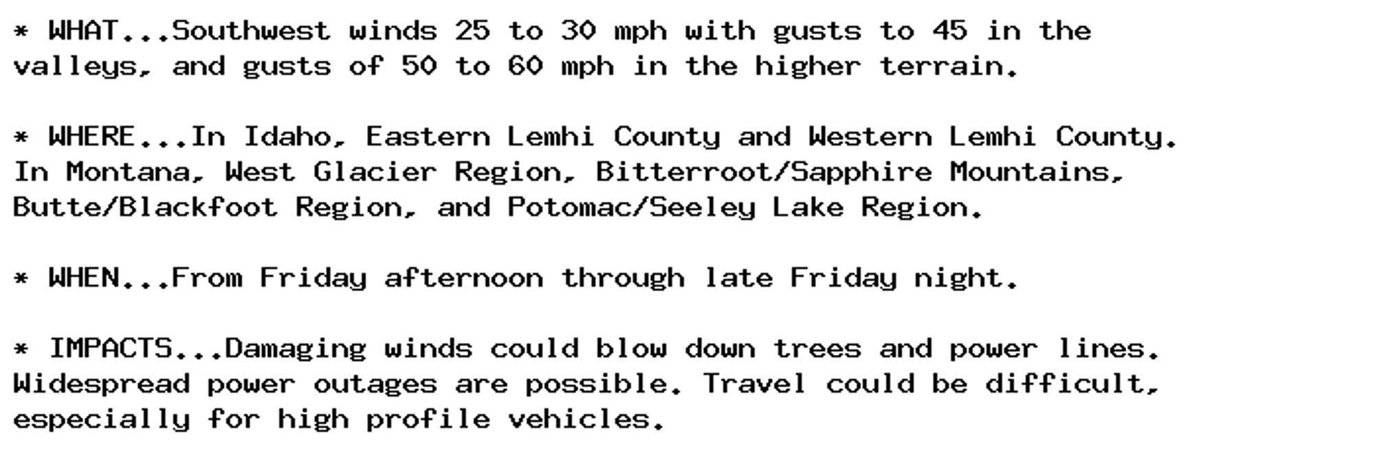
🚨 High Wind Watch issued October 2 at 12:48PM MDT until October 5 at 3:00AM MDT by NWS Missoula MT 🚨 Additional Details Here.

* WHAT...Southwest winds 25 to 30 mph with gusts to 45 in the
valleys, and gusts of 50 to 60 mph in the higher terrain.

* WHERE...In Idaho, Eastern Lemhi County and Western Lemhi County.
In Montana, West Glacier Region, Bitterroot/Sapphire Mountains,
Butte/Blackfoot Region, and Potomac/Seeley Lake Region.

* WHEN...From Friday afternoon through late Friday night.

* IMPACTS...Damaging winds could blow down trees and power lines.
Widespread power outages are possible. Travel could be difficult,
especially for high profile vehicles.
0
AFmso.nws-bot.us

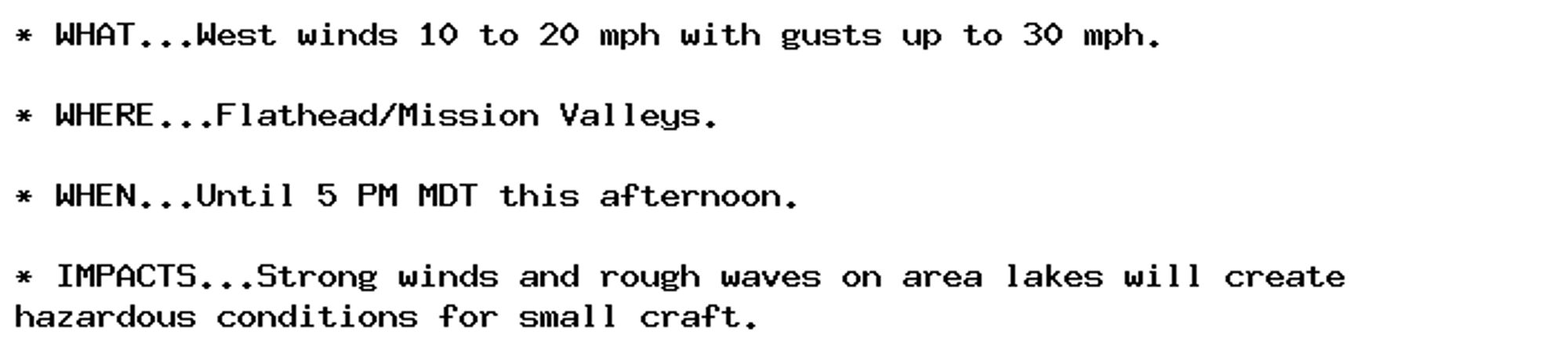
Lake Wind Advisory issued October 2 at 12:48PM MDT until October 2 at 5:00PM MDT by NWS Missoula MT Additional Details Here.

* WHAT...West winds 10 to 20 mph with gusts up to 30 mph.

* WHERE...Flathead/Mission Valleys.

* WHEN...Until 5 PM MDT this afternoon.

* IMPACTS...Strong winds and rough waves on area lakes will create
hazardous conditions for small craft.
0
AFmso.nws-bot.us

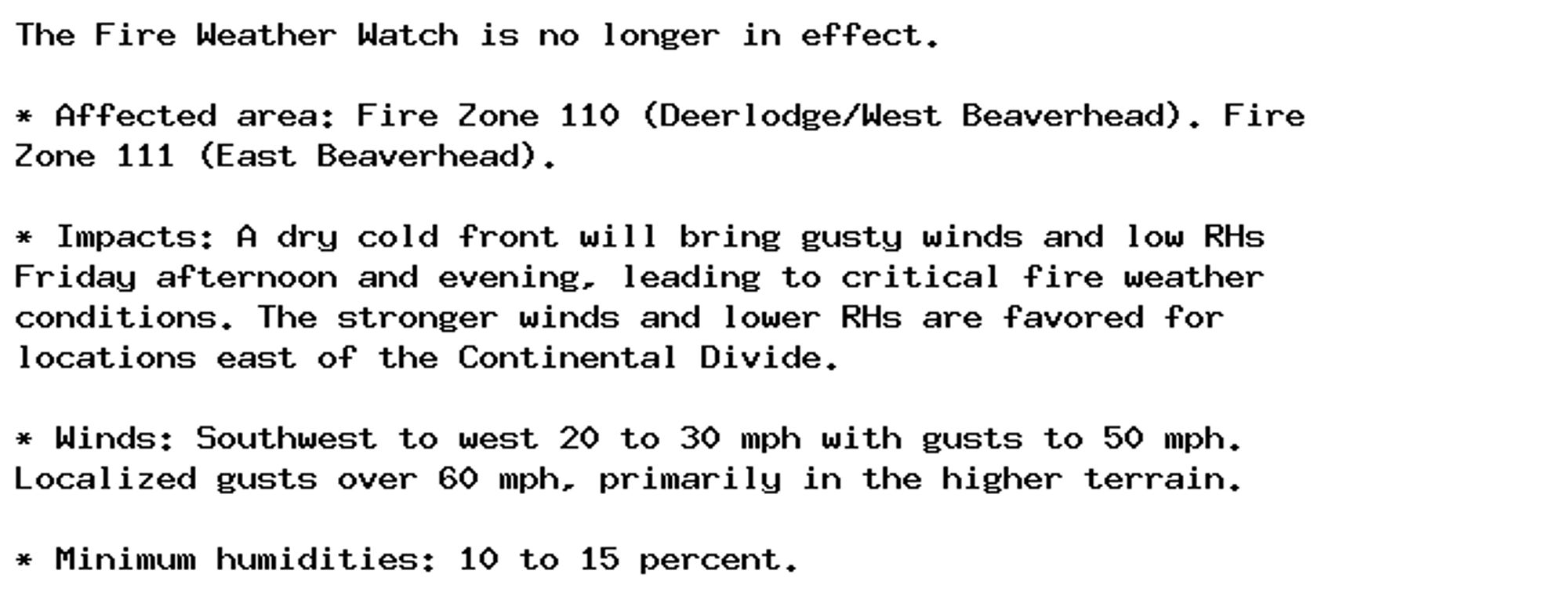
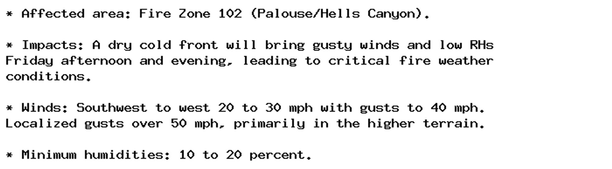
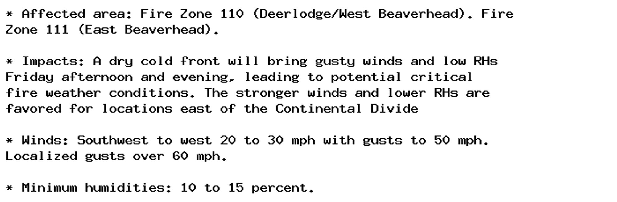
🚨 Fire Weather Watch issued October 2 at 12:49PM MDT until October 4 at 10:00PM MDT by NWS Missoula MT 🚨 Additional Details Here.

* Affected area: Fire Zone 110 (Deerlodge/West Beaverhead). Fire
Zone 111 (East Beaverhead).

* Impacts: A dry cold front will bring gusty winds and low RHs
Friday afternoon and evening, leading to potential critical
fire weather conditions. The stronger winds and lower RHs are
favored for locations east of the Continental Divide

* Winds: Southwest to west 20 to 30 mph with gusts to 50 mph.
Localized gusts over 60 mph.

* Minimum humidities: 10 to 15 percent.
0
AFmso.nws-bot.us

Lake Wind Advisory issued October 1 at 10:04AM MDT until October 2 at 5:00PM MDT by NWS Missoula MT Additional Details Here.

* WHAT...South to southwest winds 15 to 25 mph with gusts up to 30
mph expected. Waves 1 to 2 feet, locally 3 feet.

* WHERE...Flathead/Mission Valleys. Flathead Lake. Other area lakes.

* WHEN...From 5 PM this afternoon to 5 PM MDT Wednesday.

* IMPACTS...Strong winds and rough waves on area lakes will create
hazardous conditions for small craft.
0
AF
Alerts from NWS Missoula MT (UNOFFICIAL)
@mso.nws-bot.us
Unofficial bot sharing alerts from NWS Missoula MT. This account is not monitored. Contact @wandrme.paxex.aero if needed.
108 followers1 following27 posts