BLUE
NH
National Hurricane Center - Atlantic Alerts (UNOFFICIAL)
@nhc-atlc.nws-bot.us
Unofficial bot sharing alerts from National Hurricane Center - Atlantic. This account is not monitored. Contact @wandrme.paxex.aero if needed.
622 followers1 following145 posts
NHnhc-atlc.nws-bot.us

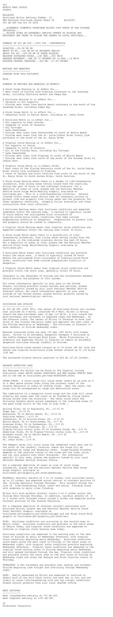
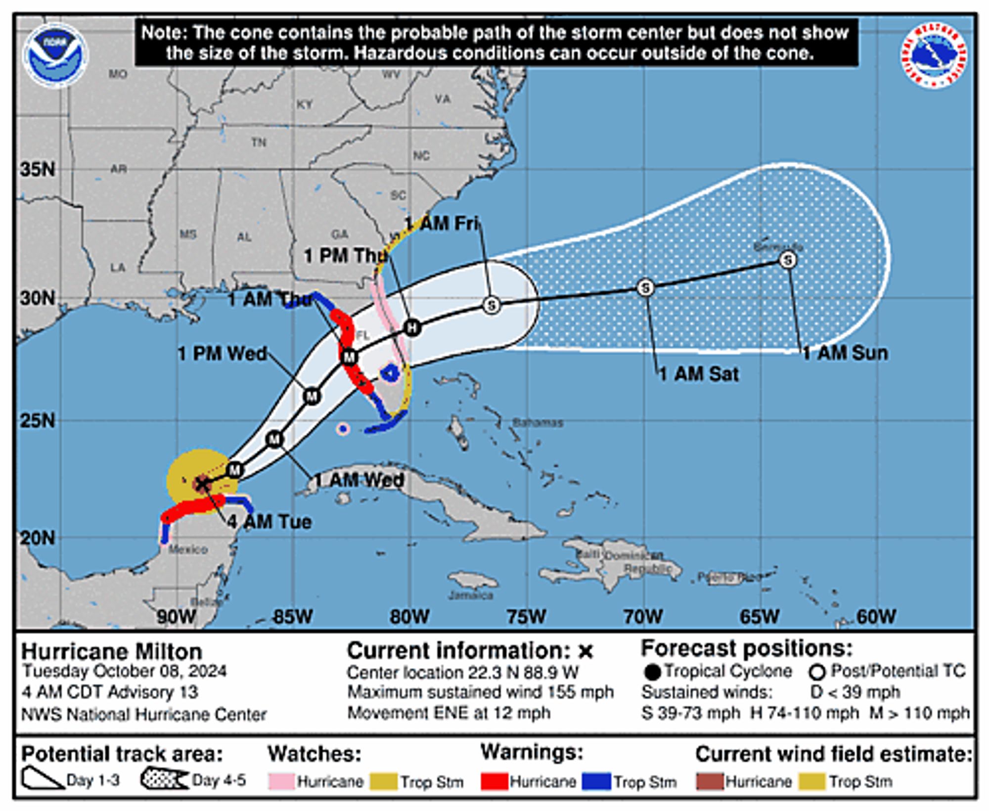
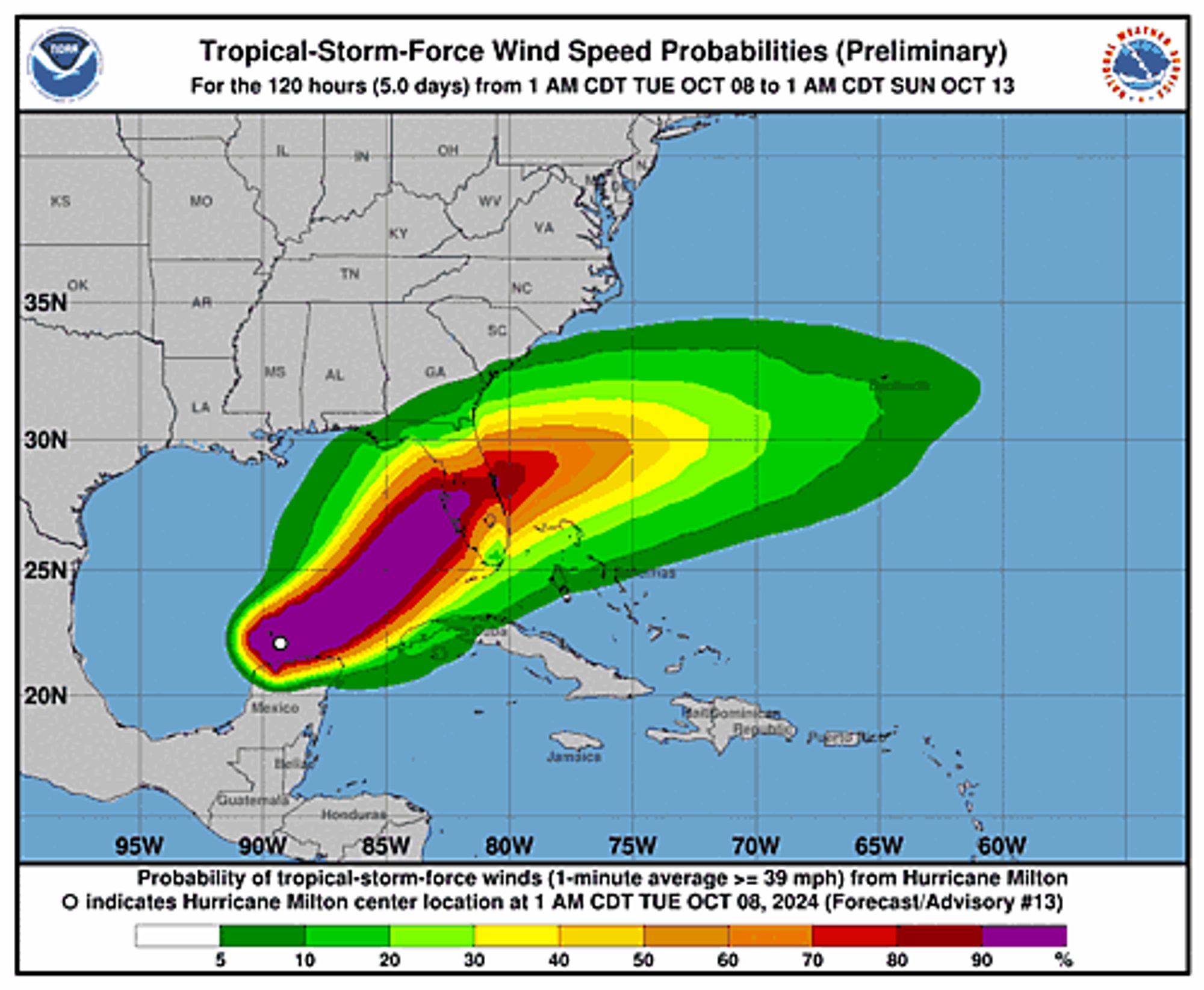
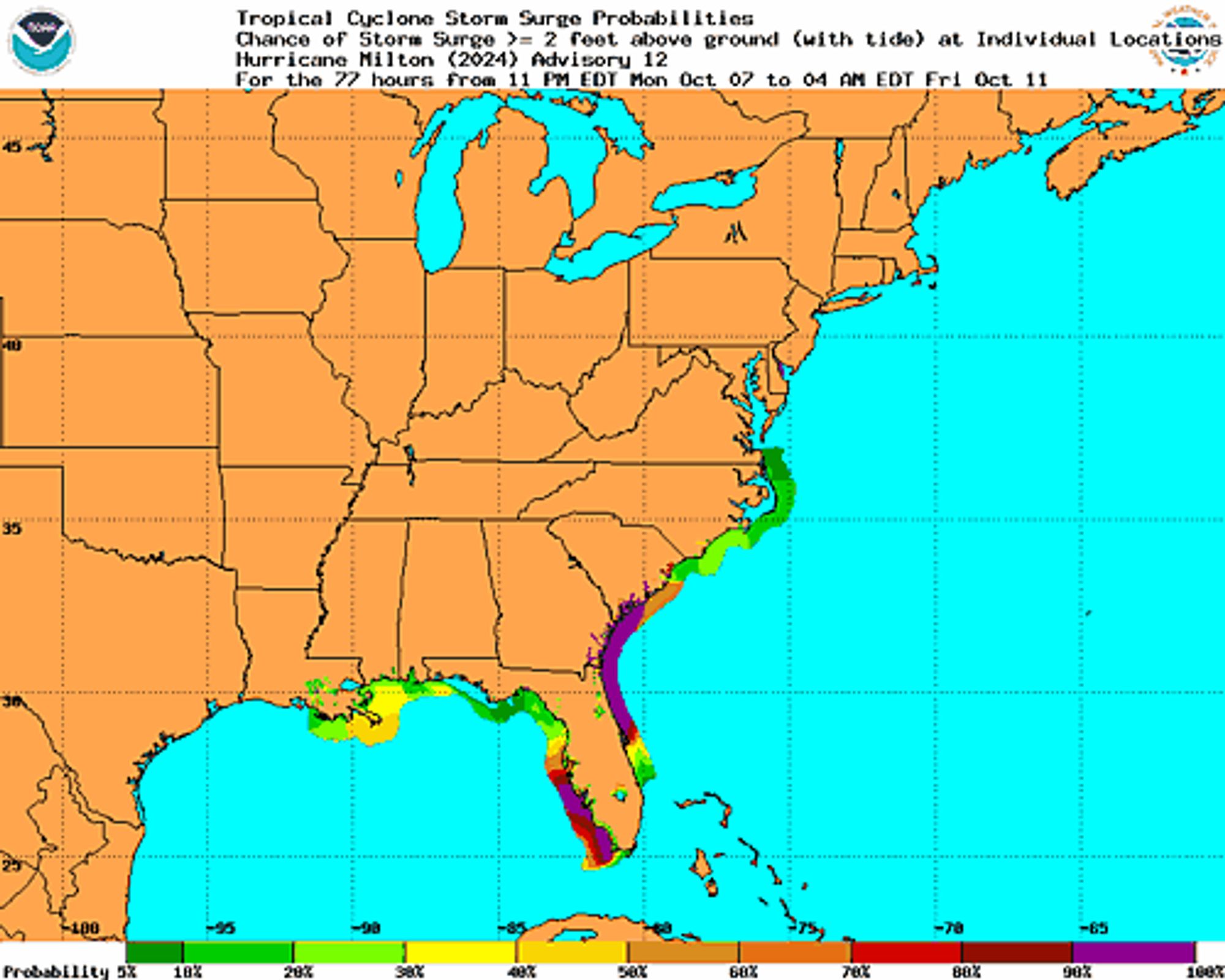
Atlantic Hurricane Milton Advisory Number 13 issued at Tue, 08 Oct 2024 08:32:24 +0000 ...EXTREMELY POWERFUL HURRICANE MILTON JUST NORTH OF THE YUCATAN PENINSULA... ...MILTON POSES AN EXTREMELY SERIOUS THREAT TO FLORIDA AND RESIDENTS ARE URGED TO FOLLOW THE ORDER... Additional Details Here.


 <br />
 000<br />
 WTNT34 KNHC 080832<br />
 TCPAT4<br />
  <br />
 BULLETIN<br />
 Hurricane Milton Advisory Number  13<br />
 NWS National Hurricane Center Miami FL       AL142024<br />
 400 AM CDT Tue Oct 08 2024<br />
  <br />
 ...EXTREMELY POWERFUL HURRICANE MILTON JUST NORTH OF THE YUCATAN<br />
 PENINSULA...<br />
 ...MILTON POSES AN EXTREMELY SERIOUS THREAT TO FLORIDA AND<br />
 RESIDENTS ARE URGED TO FOLLOW THE ORDERS OF LOCAL OFFICIALS...<br />
  <br />
  <br />
 SUMMARY OF 400 AM CDT...0900 UTC...INFORMATION<br />
 ----------------------------------------------<br />
 LOCATION...22.3N 88.9W<br />
 ABOUT 85 MI...140 KM NE OF PROGRESO MEXICO<br />
 ABOUT 560 MI...905 KM SW OF TAMPA FLORIDA<br />
 MAXIMUM SUSTAINED WINDS...155 MPH...250 KM/H<br />
 PRESENT MOVEMENT...ENE OR 75 DEGREES AT 12 MPH...19 KM/H<br />
 MINIMUM CENTRAL PRESSURE...924 MB...27.29 INCHES<br />
  <br />
  <br />
 WATCHES AND WARNINGS<br />
 --------------------<br />
 CHANGES WITH THIS ADVISORY:<br />
  <br />
 None.<br />
  <br />
 SUMMARY OF WATCHES AND WARNINGS IN EFFECT:<br />
  <br />
 A Storm Surge Warning is in effect for...<br />
 * West coast of Florida from Flamingo northward to the Suwannee<br />
 River, including Charlotte Harbor and Tampa Bay<br />
  <br />
 A Hurricane Warning is in effect for...<br />
 * Celestun to Rio Lagartos<br />
 * Florida west coast from Bonita Beach northward to the mouth of the<br />
 Suwannee River, including Tampa Bay<br />
  <br />
 A Storm Surge Watch is in effect for...<br />
 * Sebastian Inlet to Edisto Beach, including St. Johns River<br />
  <br />
 A Hurricane Watch is in effect for...<br />
 * Rio Lagartos to Cabo Catoche<br />
 * Campeche to south of Celestun<br />
 * Dry Tortugas<br />
 * Lake Okeechobee<br />
 * Florida west coast from Chokoloskee to south of Bonita Beach<br />
 * Florida east coast from the St. Lucie/Indian River County Line<br />
 northward to the mouth of the St. Marys River<br />
  <br />
 A Tropical Storm Warning is in effect for...<br />
 * Rio Lagartos to Cancun<br />
 * Campeche to south of Celestun<br />
 * All of the Florida Keys, including Dry Tortugas<br />
 * Lake Okeechobee<br />
 * Florida west coast from Flamingo to south of Bonita Beach<br />
 * Florida west coast from north of the mouth of the Suwanee River to<br />
 Indian Pass<br />
  <br />
 A Tropical Storm Watch is in effect for…<br />
 * East coast of the Florida Peninsula south of the St. Lucie/Indian<br />
 River County Line southward to Flamingo<br />
 * Coast of Georgia and South Carolina from north of the mouth of the<br />
 St. Marys River to South Santee River, South Carolina<br />
  <br />
 A Storm Surge Warning means there is a danger of life-threatening<br />
 inundation, from rising water moving inland from the coastline,<br />
 during the next 36 hours in the indicated locations. For a<br />
 depiction of areas at risk, please see the National Weather<br />
 Service Storm Surge Watch/Warning Graphic, available at<br />
 hurricanes.gov.  This is a life-threatening situation.  Persons<br />
 located within these areas should take all necessary actions to<br />
 protect life and property from rising water and the potential for<br />
 other dangerous conditions.  Promptly follow evacuation and other<br />
 instructions from local officials.<br />
  <br />
 A Hurricane Warning means that hurricane conditions are expected<br />
 somewhere within the warning area.  A warning is typically issued<br />
 36 hours before the anticipated first occurrence of<br />
 tropical-storm-force winds, conditions that make outside<br />
 preparations difficult or dangerous.  Preparations to protect life<br />
 and property should be rushed to completion.<br />
  <br />
 A Tropical Storm Warning means that tropical storm conditions are<br />
 expected somewhere within the warning area within 36 hours.<br />
  <br />
 A Storm Surge Watch means there is a possibility of life-<br />
 threatening inundation, from rising water moving inland from the<br />
 coastline, in the indicated locations during the next 48 hours.<br />
 For a depiction of areas at risk, please see the National Weather<br />
 Service Storm Surge Watch/Warning Graphic, available at<br />
 hurricanes.gov.<br />
  <br />
 A Hurricane Watch means that hurricane conditions are possible<br />
 within the watch area.  A watch is typically issued 48 hours<br />
 before the anticipated first occurrence of tropical-storm-force<br />
 winds, conditions that make outside preparations difficult or<br />
 dangerous.<br />
  <br />
 A Tropical Storm Watch means that tropical storm conditions are<br />
 possible within the watch area, generally within 48 hours.<br />
  <br />
 Interests in the remainder of Florida and the northwestern Bahamas<br />
 should monitor the progress of this system.<br />
  <br />
 For storm information specific to your area in the United<br />
 States, including possible inland watches and warnings, please<br />
 monitor products issued by your local National Weather Service<br />
 forecast office. For storm information specific to your area<br />
 outside of the United States, please monitor products issued by<br />
 your national meteorological service.<br />
  <br />
  <br />
 DISCUSSION AND OUTLOOK<br />
 ----------------------<br />
 At 400 AM CDT (0900 UTC), the center of Hurricane Milton was located<br />
 near latitude 22.3 North, longitude 88.9 West. Milton is moving<br />
 toward the east-northeast near 12 mph (19 km/h). A turn toward the<br />
 east-northeast and northeast is expected today and Wednesday.  On<br />
 the forecast track, the center of Milton is forecast to move just<br />
 north of the Yucatan Peninsula today and approach the west coast of<br />
 the Florida Peninsula on Wednesday.  The hurricane is forecast to<br />
 make landfall in Florida Wednesday night.<br />
  <br />
 Maximum sustained winds are near 155 mph (250 km/h) with higher<br />
 gusts.  Milton is an extremely dangerous category 4 hurricane on<br />
 the Saffir-Simpson Hurricane Wind Scale.  While fluctuations in<br />
 intensity are expected, Milton is forecast to remain an extremely<br />
 dangerous hurricane through landfall in Florida.<br />
  <br />
 Hurricane-force winds extend outward up to 30 miles (45 km) from the<br />
 center and tropical-storm-force winds extend outward up to 105 miles<br />
 (165 km).<br />
  <br />
 The estimated minimum central pressure is 924 mb (27.29 inches).<br />
  <br />
  <br />
 HAZARDS AFFECTING LAND<br />
 ----------------------<br />
 Key Messages for Milton can be found in the Tropical Cyclone<br />
 Discussion under AWIPS header MIATCDAT4 and WMO header WTNT44 KNHC<br />
 and on the web at hurricanes.gov/text/MIATCDAT4.shtml<br />
  <br />
 STORM SURGE:  A storm surge will raise water levels by as much as 4<br />
 to 6 feet above ground level along the northern coast of the<br />
 Yucatan Peninsula in areas of onshore winds.  Near the coast, the<br />
 surge will be accompanied by large and destructive waves.<br />
  <br />
 The combination of a dangerous storm surge and the tide will cause<br />
 normally dry areas near the coast to be flooded by rising waters<br />
 moving inland from the shoreline.  The water could reach the<br />
 following heights above ground somewhere in the indicated areas if<br />
 the peak surge occurs at the time of high tide...<br />
  <br />
 Anclote River, FL to Englewood, FL...10-15 ft<br />
 Tampa Bay...10-15 ft<br />
 Englewood, FL to Bonita Beach, FL...6-10 ft<br />
 Charlotte Harbor...6-10 ft<br />
 Yankeetown, FL to Anclote River, FL...5-10 ft<br />
 Bonita Beach, FL to Chokoloskee, FL...4-7 ft<br />
 Suwannee River, FL to Yankeetown, FL...3-5 ft<br />
 Chokoloskee, FL to Flamingo, FL...3-5 ft<br />
 Flagler/Volusia County Line, FL to Altamaha Sound, GA...3-5 ft<br />
 Sebastian Inlet, FL to Flagler/Volusia County Line, FL...2-4 ft<br />
 Altamaha Sound, GA to Edisto Beach, SC...2-4 ft<br />
 Dry Tortugas...2-4 ft<br />
 St. Johns River...2-4 ft<br />
  <br />
 The deepest water will occur along the immediate coast near and to<br />
 the south of the landfall location, where the surge will be<br />
 accompanied by large and dangerous waves.  Surge-related flooding<br />
 depends on the relative timing of the surge and the tidal cycle,<br />
 and can vary greatly over short distances.  For information<br />
 specific to your area, please see products issued by your local<br />
 National Weather Service forecast office.<br />
  <br />
 For a complete depiction of areas at risk of storm surge<br />
 inundation, please see the National Weather Service Peak Storm<br />
 Surge Graphic, available at<br />
 hurricanes.gov/graphics_at4.shtml?peakSurge.<br />
  <br />
 RAINFALL: Rainfall amounts of 5 to 12 inches, with localized totals<br />
 up to 18 inches, are expected across central to northern portions of<br />
 the  Florida Peninsula through Thursday.  This rainfall brings the<br />
 risk of  life-threatening flash, urban and aerial  flooding along<br />
 with moderate to major river flooding.<br />
  <br />
 Milton will also produce rainfall totals 2 to 4 inches across the<br />
 Florida Keys through Thursday. In addition, rainfall amounts of  2<br />
 to 4 inches with isolated totals around 6 inches are expected across<br />
 northern portions of the Yucatan Peninsula.<br />
  <br />
 For a complete depiction of forecast rainfall associated with<br />
 Hurricane Milton, please see the National Weather Service Storm<br />
 Total Rainfall Graphic, available at<br />
 hurricanes.gov/graphics_at4.shtml?rainqpf and the Flash Flood Risk<br />
 graphic at hurricanes.gov/graphics_at4.shtml?ero.<br />
  <br />
 WIND:  Hurricane conditions are occurring in the warning area in<br />
 Mexico today.  Hurricane conditions are possible in the watch areas<br />
 in Mexico today, and tropical storm conditions are expected to <br />
 continue in tropical storm warning area today.<br />
  <br />
 Hurricane conditions are expected in the warning area on the west<br />
 coast of Florida as early as Wednesday afternoon, with tropical<br />
 storm conditions beginning early Wednesday.  Hurricane conditions<br />
 could begin along the east coast of Florida in the watch areas on<br />
 Wednesday night, with tropical storm conditions possible beginning<br />
 Wednesday afternoon.  Tropical storm conditions are expected in the<br />
 tropical storm warning areas in Florida beginning early Wednesday<br />
 and will spread northward through the day. Tropical storm conditions<br />
 are possible within the watch area on the east coast of Florida by<br />
 Wednesday night and along the Georgia and South Carolina coasts on<br />
 Thursday.<br />
  <br />
 TORNADOES: A few tornadoes are possible over central and southern <br />
 Florida beginning late tonight and continuing through Wednesday <br />
 night.<br />
  <br />
 SURF:  Swells generated by Milton are expected to continue to<br />
 affect much of the Gulf Coast within the next day or two, and are<br />
 likely to cause life-threatening surf and rip current conditions.<br />
 Please consult products from your local weather office.<br />
  <br />
  <br />
 NEXT ADVISORY<br />
 -------------<br />
 Next intermediate advisory at 700 AM CDT.<br />
 Next complete advisory at 1000 AM CDT.<br />
  <br />
 $$<br />
 Forecaster Cangialosi<br />
  <br />
Hurricane Milton 5-Day Uncertainty Track Image
Hurricane Milton 34-Knot Wind Speed Probabilities
Hurricane Milton Probabilistic Storm Surge Graphics Image
0

NH
National Hurricane Center - Atlantic Alerts (UNOFFICIAL)
@nhc-atlc.nws-bot.us
Unofficial bot sharing alerts from National Hurricane Center - Atlantic. This account is not monitored. Contact @wandrme.paxex.aero if needed.
622 followers1 following145 posts