BLUE
NH
National Hurricane Center - Eastern Pacific Alerts (UNOFFICIAL)
@nhc-epac.nws-bot.us
Unofficial bot sharing alerts from National Hurricane Center - Eastern North Pacific. This account is not monitored. Contact @wandrme.paxex.aero if needed.
47 followers1 following29 posts
NHnhc-epac.nws-bot.us

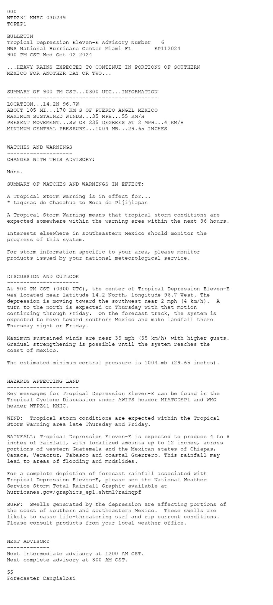
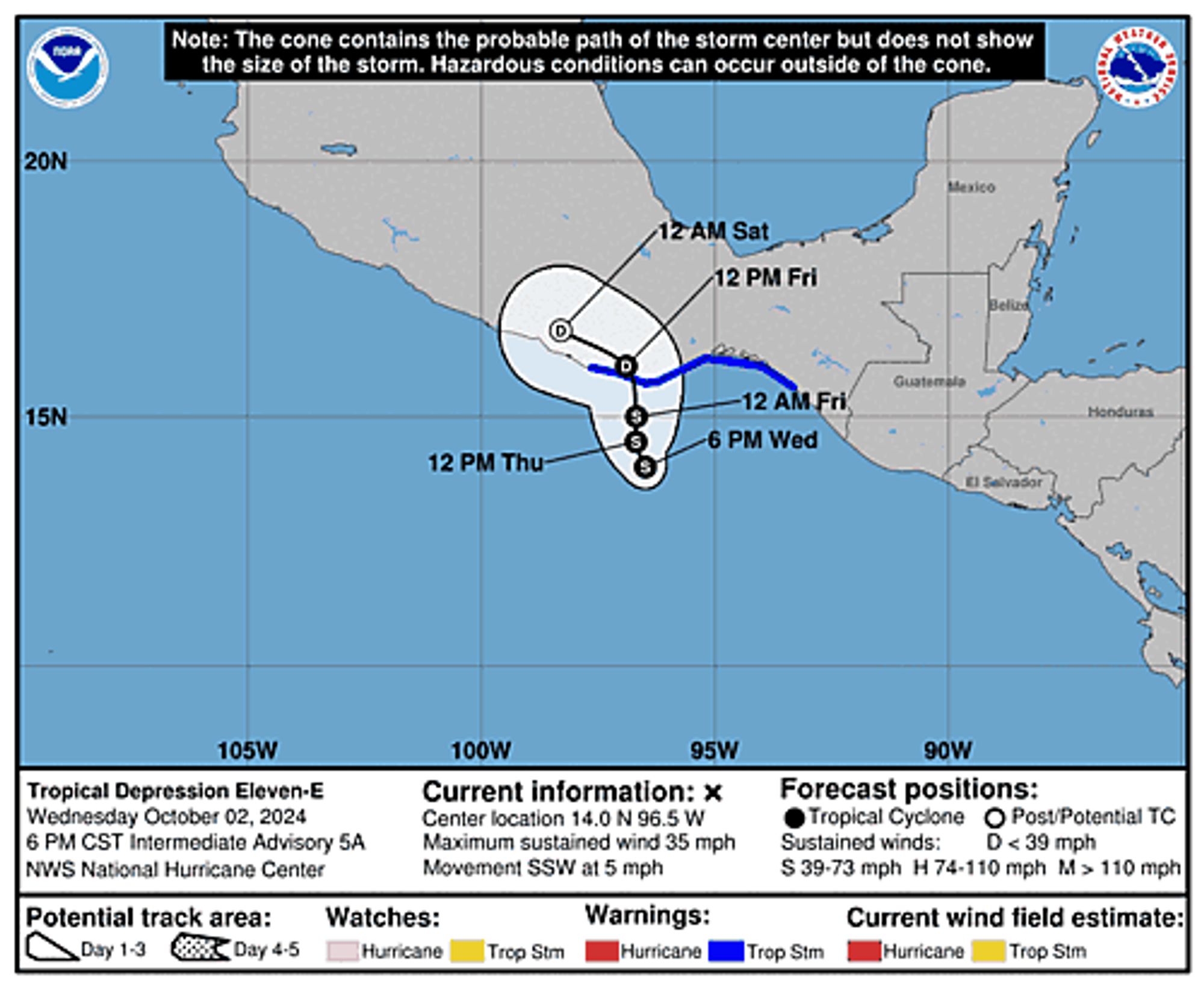
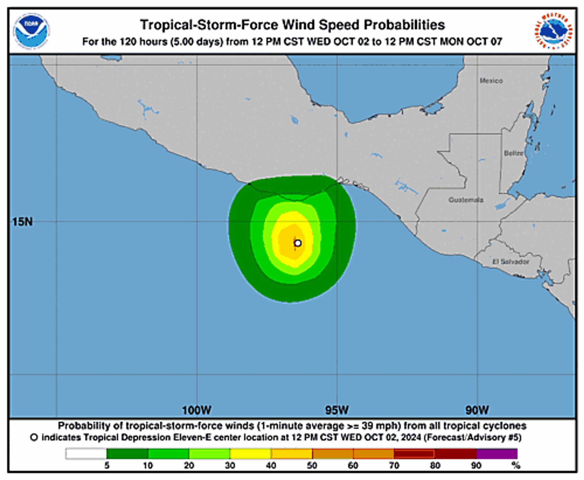
Eastern Pacific Tropical Depression Eleven-E Advisory Number 6 issued at Thu, 03 Oct 2024 02:39:10 +0000 ...HEAVY RAINS EXPECTED TO CONTINUE IN PORTIONS OF SOUTHERN MEXICO FOR ANOTHER DAY OR TWO... Additional Details Here.


 <br />
 000<br />
 WTPZ31 KNHC 030239<br />
 TCPEP1<br />
  <br />
 BULLETIN<br />
 Tropical Depression Eleven-E Advisory Number   6<br />
 NWS National Hurricane Center Miami FL       EP112024<br />
 900 PM CST Wed Oct 02 2024<br />
  <br />
 ...HEAVY RAINS EXPECTED TO CONTINUE IN PORTIONS OF SOUTHERN<br />
 MEXICO FOR ANOTHER DAY OR TWO...<br />
  <br />
  <br />
 SUMMARY OF 900 PM CST...0300 UTC...INFORMATION<br />
 ----------------------------------------------<br />
 LOCATION...14.2N 96.7W<br />
 ABOUT 105 MI...170 KM S OF PUERTO ANGEL MEXICO<br />
 MAXIMUM SUSTAINED WINDS...35 MPH...55 KM/H<br />
 PRESENT MOVEMENT...SW OR 235 DEGREES AT 2 MPH...4 KM/H<br />
 MINIMUM CENTRAL PRESSURE...1004 MB...29.65 INCHES<br />
  <br />
  <br />
 WATCHES AND WARNINGS<br />
 --------------------<br />
 CHANGES WITH THIS ADVISORY:<br />
  <br />
 None.<br />
  <br />
 SUMMARY OF WATCHES AND WARNINGS IN EFFECT:<br />
  <br />
 A Tropical Storm Warning is in effect for...<br />
 * Lagunas de Chacahua to Boca de Pijijiapan<br />
  <br />
 A Tropical Storm Warning means that tropical storm conditions are<br />
 expected somewhere within the warning area within the next 36 hours.<br />
  <br />
 Interests elsewhere in southeastern Mexico should monitor the<br />
 progress of this system.<br />
  <br />
 For storm information specific to your area, please monitor<br />
 products issued by your national meteorological service.<br />
  <br />
  <br />
 DISCUSSION AND OUTLOOK<br />
 ----------------------<br />
 At 900 PM CST (0300 UTC), the center of Tropical Depression Eleven-E<br />
 was located near latitude 14.2 North, longitude 96.7 West. The<br />
 depression is moving toward the southwest near 2 mph (4 km/h).  A <br />
 turn to the north is expected on Thursday with that motion <br />
 continuing through Friday.  On the forecast track, the system is <br />
 expected to move toward southern Mexico and make landfall there <br />
 Thursday night or Friday.<br />
 <br />
 Maximum sustained winds are near 35 mph (55 km/h) with higher gusts.<br />
 Gradual strengthening is possible until the system reaches the <br />
 coast of Mexico.<br />
  <br />
 The estimated minimum central pressure is 1004 mb (29.65 inches).<br />
  <br />
  <br />
 HAZARDS AFFECTING LAND<br />
 ----------------------<br />
 Key messages for Tropical Depression Eleven-E can be found in the<br />
 Tropical Cyclone Discussion under AWIPS header MIATCDEP1 and WMO<br />
 header WTPZ41 KNHC.<br />
  <br />
 WIND:  Tropical storm conditions are expected within the Tropical<br />
 Storm Warning area late Thursday and Friday.<br />
  <br />
 RAINFALL: Tropical Depression Eleven-E is expected to produce 4 to 8<br />
 inches of rainfall, with localized amounts up to 12 inches, across<br />
 portions of western Guatemala and the Mexican states of Chiapas,<br />
 Oaxaca, Veracruz, Tabasco and coastal Guerrero. This rainfall may<br />
 lead to areas of flooding and mudslides.<br />
  <br />
 For a complete depiction of forecast rainfall associated with<br />
 Tropical Depression Eleven-E, please see the National Weather<br />
 Service Storm Total Rainfall Graphic available at<br />
 hurricanes.gov/graphics_ep1.shtml?rainqpf<br />
  <br />
 SURF:  Swells generated by the depression are affecting portions of<br />
 the coast of southern and southeastern Mexico.  These swells are<br />
 likely to cause life-threatening surf and rip current conditions.<br />
 Please consult products from your local weather office.<br />
  <br />
  <br />
 NEXT ADVISORY<br />
 -------------<br />
 Next intermediate advisory at 1200 AM CST.<br />
 Next complete advisory at 300 AM CST.<br />
  <br />
 $$<br />
 Forecaster Cangialosi<br />
  <br />
Tropical Depression Eleven-E 5-Day Uncertainty Track Image
Tropical Depression Eleven-E 34-Knot Wind Speed Probabilities
0

NH
National Hurricane Center - Eastern Pacific Alerts (UNOFFICIAL)
@nhc-epac.nws-bot.us
Unofficial bot sharing alerts from National Hurricane Center - Eastern North Pacific. This account is not monitored. Contact @wandrme.paxex.aero if needed.
47 followers1 following29 posts