BLUE
AF
Alerts from NWS Wakefield VA (RIC/ORF/PHF) (UNOFFICIAL)
@orf.nws-bot.us
Unofficial bot sharing alerts from NWS Wakefield VA, including Newport News, Richmond, and Norfolk areas This account is not monitored. Contact @wandrme.paxex.aero if needed.
153 followers1 following597 posts
AForf.nws-bot.us

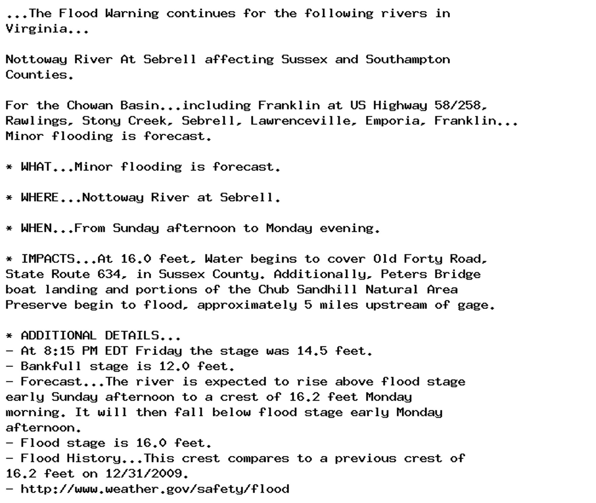
🚨 Flood Warning issued October 4 at 9:24PM EDT until October 7 at 8:00PM EDT by NWS Wakefield VA 🚨 Additional Details Here.

...The Flood Warning continues for the following rivers in
Virginia...

Nottoway River At Sebrell affecting Sussex and Southampton
Counties.

For the Chowan Basin...including Franklin at US Highway 58/258,
Rawlings, Stony Creek, Sebrell, Lawrenceville, Emporia, Franklin...
Minor flooding is forecast.

* WHAT...Minor flooding is forecast.

* WHERE...Nottoway River at Sebrell.

* WHEN...From Sunday afternoon to Monday evening.

* IMPACTS...At 16.0 feet, Water begins to cover Old Forty Road,
State Route 634, in Sussex County. Additionally, Peters Bridge
boat landing and portions of the Chub Sandhill Natural Area
Preserve begin to flood, approximately 5 miles upstream of gage.

* ADDITIONAL DETAILS...
- At 8:15 PM EDT Friday the stage was 14.5 feet.
- Bankfull stage is 12.0 feet.
- Forecast...The river is expected to rise above flood stage
early Sunday afternoon to a crest of 16.2 feet Monday
morning. It will then fall below flood stage early Monday
afternoon.
- Flood stage is 16.0 feet.
- Flood History...This crest compares to a previous crest of
16.2 feet on 12/31/2009.
- http://www.weather.gov/safety/flood
0

AF
Alerts from NWS Wakefield VA (RIC/ORF/PHF) (UNOFFICIAL)
@orf.nws-bot.us
Unofficial bot sharing alerts from NWS Wakefield VA, including Newport News, Richmond, and Norfolk areas This account is not monitored. Contact @wandrme.paxex.aero if needed.
153 followers1 following597 posts