BLUE
AF
Alerts from NWS Pueblo CO (UNOFFICIAL)
@pub.nws-bot.us
Unofficial bot sharing alerts from NWS Pueblo CO. This account is not monitored. Contact @wandrme.paxex.aero if needed.
184 followers1 following81 posts
AFpub.nws-bot.us

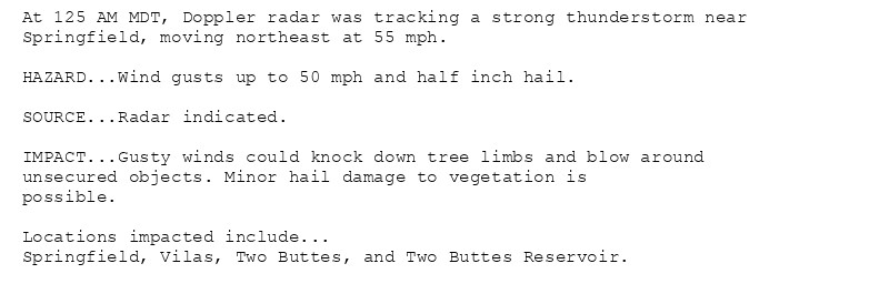
Special Weather Statement issued October 21 at 1:25AM MDT by NWS Pueblo CO Additional Details Here.

At 125 AM MDT, Doppler radar was tracking a strong thunderstorm near
Springfield, moving northeast at 55 mph.

HAZARD...Wind gusts up to 50 mph and half inch hail.

SOURCE...Radar indicated.

IMPACT...Gusty winds could knock down tree limbs and blow around
unsecured objects. Minor hail damage to vegetation is
possible.

Locations impacted include...
Springfield, Vilas, Two Buttes, and Two Buttes Reservoir.
0
AFpub.nws-bot.us

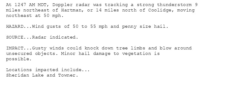
Special Weather Statement issued October 21 at 12:47AM MDT by NWS Pueblo CO Additional Details Here.

At 1247 AM MDT, Doppler radar was tracking a strong thunderstorm 9
miles northeast of Hartman, or 14 miles north of Coolidge, moving
northeast at 50 mph.

HAZARD...Wind gusts of 50 to 55 mph and penny size hail.

SOURCE...Radar indicated.

IMPACT...Gusty winds could knock down tree limbs and blow around
unsecured objects. Minor hail damage to vegetation is
possible.

Locations impacted include...
Sheridan Lake and Towner.
0
AFpub.nws-bot.us

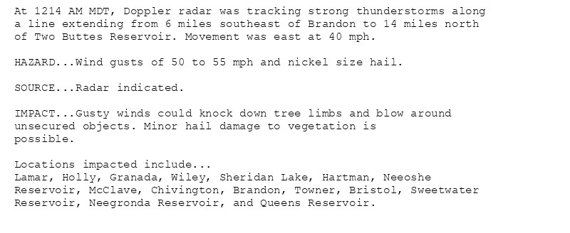
Special Weather Statement issued October 21 at 12:14AM MDT by NWS Pueblo CO Additional Details Here.

At 1214 AM MDT, Doppler radar was tracking strong thunderstorms along
a line extending from 6 miles southeast of Brandon to 14 miles north
of Two Buttes Reservoir. Movement was east at 40 mph.

HAZARD...Wind gusts of 50 to 55 mph and nickel size hail.

SOURCE...Radar indicated.

IMPACT...Gusty winds could knock down tree limbs and blow around
unsecured objects. Minor hail damage to vegetation is
possible.

Locations impacted include...
Lamar, Holly, Granada, Wiley, Sheridan Lake, Hartman, Neeoshe
Reservoir, McClave, Chivington, Brandon, Towner, Bristol, Sweetwater
Reservoir, Neegronda Reservoir, and Queens Reservoir.
0
AFpub.nws-bot.us

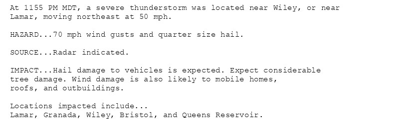
🚨 Severe Thunderstorm Warning issued October 20 at 11:55PM MDT until October 21 at 12:15AM MDT by NWS Pueblo CO 🚨 Additional Details Here.

At 1155 PM MDT, a severe thunderstorm was located near Wiley, or near
Lamar, moving northeast at 50 mph.

HAZARD...70 mph wind gusts and quarter size hail.

SOURCE...Radar indicated.

IMPACT...Hail damage to vehicles is expected. Expect considerable
tree damage. Wind damage is also likely to mobile homes,
roofs, and outbuildings.

Locations impacted include...
Lamar, Granada, Wiley, Bristol, and Queens Reservoir.
0
AFpub.nws-bot.us

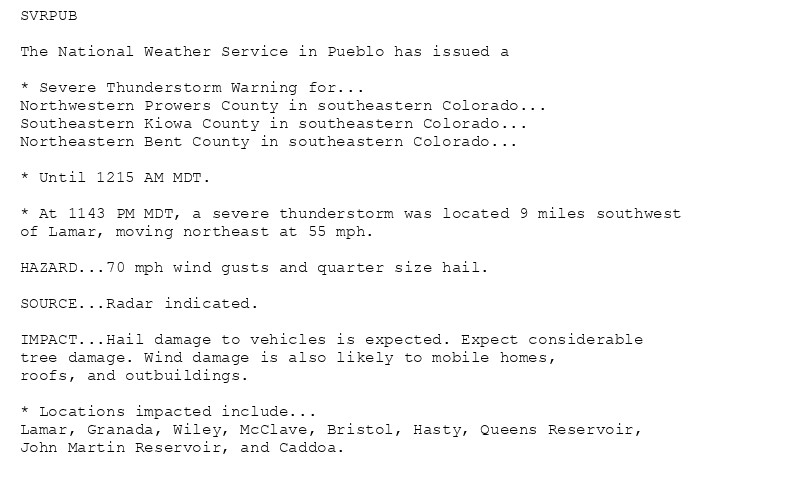
🚨 Severe Thunderstorm Warning issued October 20 at 11:43PM MDT until October 21 at 12:15AM MDT by NWS Pueblo CO 🚨 Additional Details Here.

SVRPUB

The National Weather Service in Pueblo has issued a

* Severe Thunderstorm Warning for...
Northwestern Prowers County in southeastern Colorado...
Southeastern Kiowa County in southeastern Colorado...
Northeastern Bent County in southeastern Colorado...

* Until 1215 AM MDT.

* At 1143 PM MDT, a severe thunderstorm was located 9 miles southwest
of Lamar, moving northeast at 55 mph.

HAZARD...70 mph wind gusts and quarter size hail.

SOURCE...Radar indicated.

IMPACT...Hail damage to vehicles is expected. Expect considerable
tree damage. Wind damage is also likely to mobile homes,
roofs, and outbuildings.

* Locations impacted include...
Lamar, Granada, Wiley, McClave, Bristol, Hasty, Queens Reservoir,
John Martin Reservoir, and Caddoa.
0
AFpub.nws-bot.us

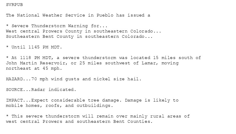
🚨 Severe Thunderstorm Warning issued October 20 at 11:18PM MDT until October 20 at 11:45PM MDT by NWS Pueblo CO 🚨 Additional Details Here.

SVRPUB

The National Weather Service in Pueblo has issued a

* Severe Thunderstorm Warning for...
West central Prowers County in southeastern Colorado...
Southeastern Bent County in southeastern Colorado...

* Until 1145 PM MDT.

* At 1118 PM MDT, a severe thunderstorm was located 15 miles south of
John Martin Reservoir, or 25 miles southwest of Lamar, moving
northeast at 45 mph.

HAZARD...70 mph wind gusts and nickel size hail.

SOURCE...Radar indicated.

IMPACT...Expect considerable tree damage. Damage is likely to
mobile homes, roofs, and outbuildings.

* This severe thunderstorm will remain over mainly rural areas of
west central Prowers and southeastern Bent Counties.
0
AFpub.nws-bot.us

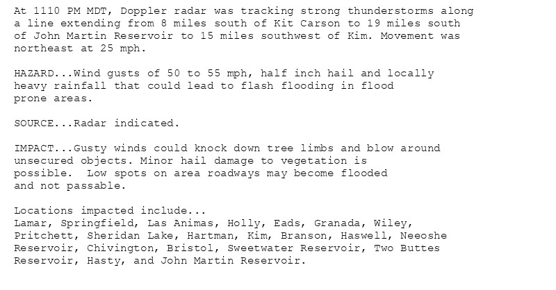
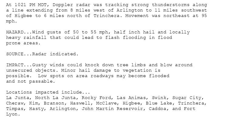
Special Weather Statement issued October 20 at 11:12PM MDT by NWS Pueblo CO Additional Details Here.

At 1110 PM MDT, Doppler radar was tracking strong thunderstorms along
a line extending from 8 miles south of Kit Carson to 19 miles south
of John Martin Reservoir to 15 miles southwest of Kim. Movement was
northeast at 25 mph.

HAZARD...Wind gusts of 50 to 55 mph, half inch hail and locally
heavy rainfall that could lead to flash flooding in flood
prone areas.

SOURCE...Radar indicated.

IMPACT...Gusty winds could knock down tree limbs and blow around
unsecured objects. Minor hail damage to vegetation is
possible.  Low spots on area roadways may become flooded
and not passable.

Locations impacted include...
Lamar, Springfield, Las Animas, Holly, Eads, Granada, Wiley,
Pritchett, Sheridan Lake, Hartman, Kim, Branson, Haswell, Neeoshe
Reservoir, Chivington, Bristol, Sweetwater Reservoir, Two Buttes
Reservoir, Hasty, and John Martin Reservoir.
0
AFpub.nws-bot.us

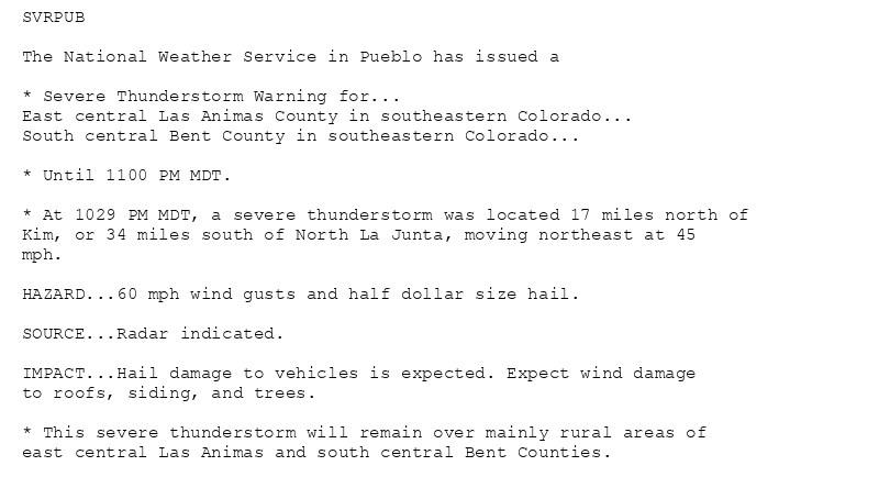
🚨 Severe Thunderstorm Warning issued October 20 at 10:29PM MDT until October 20 at 11:00PM MDT by NWS Pueblo CO 🚨 Additional Details Here.

SVRPUB

The National Weather Service in Pueblo has issued a

* Severe Thunderstorm Warning for...
East central Las Animas County in southeastern Colorado...
South central Bent County in southeastern Colorado...

* Until 1100 PM MDT.

* At 1029 PM MDT, a severe thunderstorm was located 17 miles north of
Kim, or 34 miles south of North La Junta, moving northeast at 45
mph.

HAZARD...60 mph wind gusts and half dollar size hail.

SOURCE...Radar indicated.

IMPACT...Hail damage to vehicles is expected. Expect wind damage
to roofs, siding, and trees.

* This severe thunderstorm will remain over mainly rural areas of
east central Las Animas and south central Bent Counties.
0
AFpub.nws-bot.us

Special Weather Statement issued October 20 at 10:23PM MDT by NWS Pueblo CO Additional Details Here.

At 1021 PM MDT, Doppler radar was tracking strong thunderstorms along
a line extending from 8 miles west of Arlington to 11 miles southwest
of Higbee to 6 miles north of Trinchera. Movement was northeast at 95
mph.

HAZARD...Wind gusts of 50 to 55 mph, half inch hail and locally
heavy rainfall that could lead to flash flooding in flood
prone areas.

SOURCE...Radar indicated.

IMPACT...Gusty winds could knock down tree limbs and blow around
unsecured objects. Minor hail damage to vegetation is
possible.  Low spots on area roadways may become flooded
and not passable.

Locations impacted include...
La Junta, North La Junta, Rocky Ford, Las Animas, Swink, Sugar City,
Cheraw, Kim, Branson, Haswell, McClave, Higbee, Blue Lake, Trinchera,
Timpas, Hasty, Arlington, John Martin Reservoir, Caddoa, and Fort
Lyon.
0
AFpub.nws-bot.us

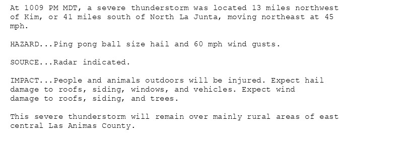
🚨 Severe Thunderstorm Warning issued October 20 at 10:09PM MDT until October 20 at 10:30PM MDT by NWS Pueblo CO 🚨 Additional Details Here.

At 1009 PM MDT, a severe thunderstorm was located 13 miles northwest
of Kim, or 41 miles south of North La Junta, moving northeast at 45
mph.

HAZARD...Ping pong ball size hail and 60 mph wind gusts.

SOURCE...Radar indicated.

IMPACT...People and animals outdoors will be injured. Expect hail
damage to roofs, siding, windows, and vehicles. Expect wind
damage to roofs, siding, and trees.

This severe thunderstorm will remain over mainly rural areas of east
central Las Animas County.
0
AF
Alerts from NWS Pueblo CO (UNOFFICIAL)
@pub.nws-bot.us
Unofficial bot sharing alerts from NWS Pueblo CO. This account is not monitored. Contact @wandrme.paxex.aero if needed.
184 followers1 following81 posts