BLUE
SF
SPC Fire Weather Outlooks Alerts (UNOFFICIAL)
@spc-fire.nws-bot.us
Unofficial bot sharing alerts from the NWS SPC Fire Weather Outlook. This account is not monitored. Contact @wandrme.paxex.aero if needed.
18 followers1 following44 posts
SFspc-fire.nws-bot.us

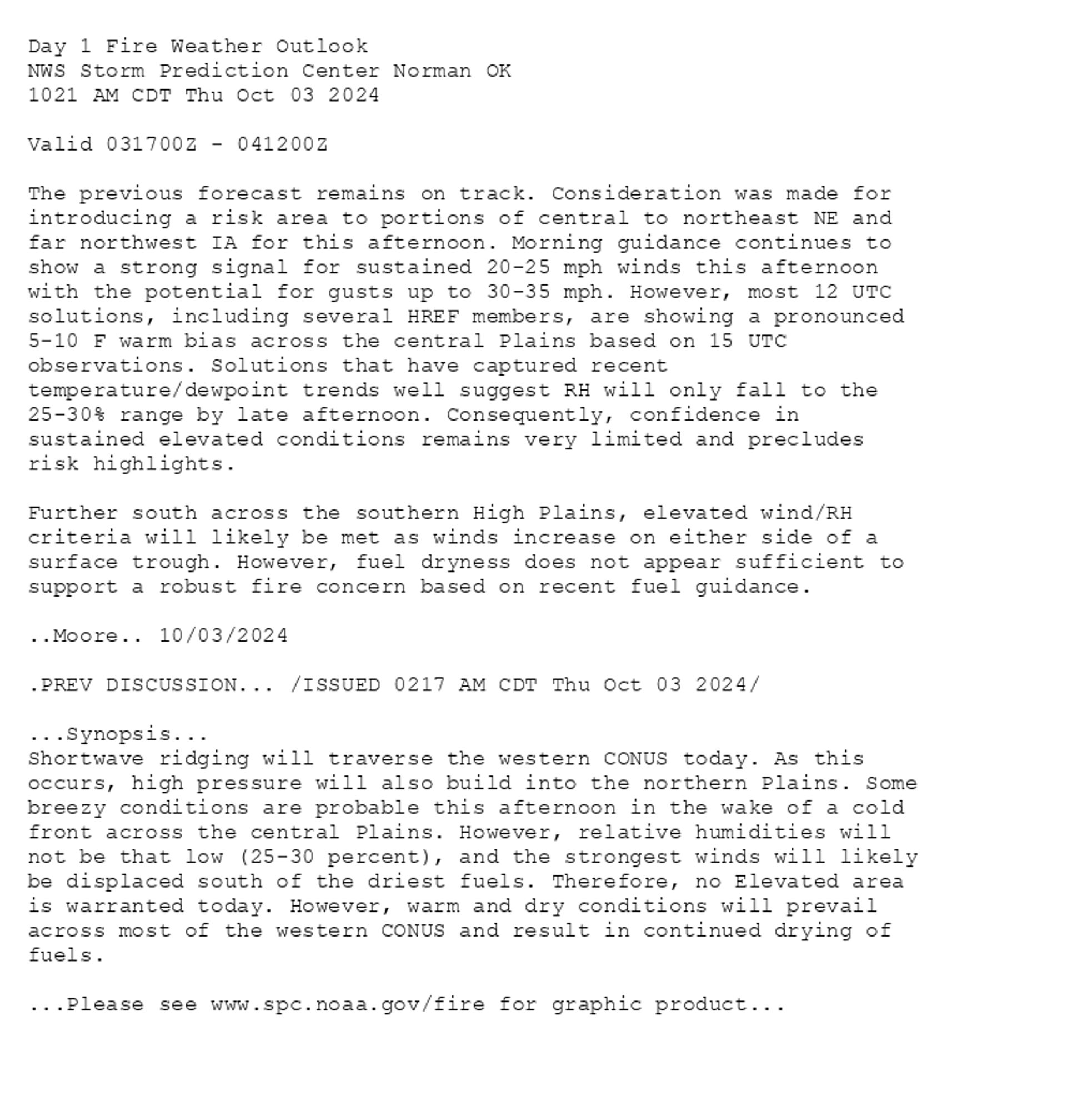
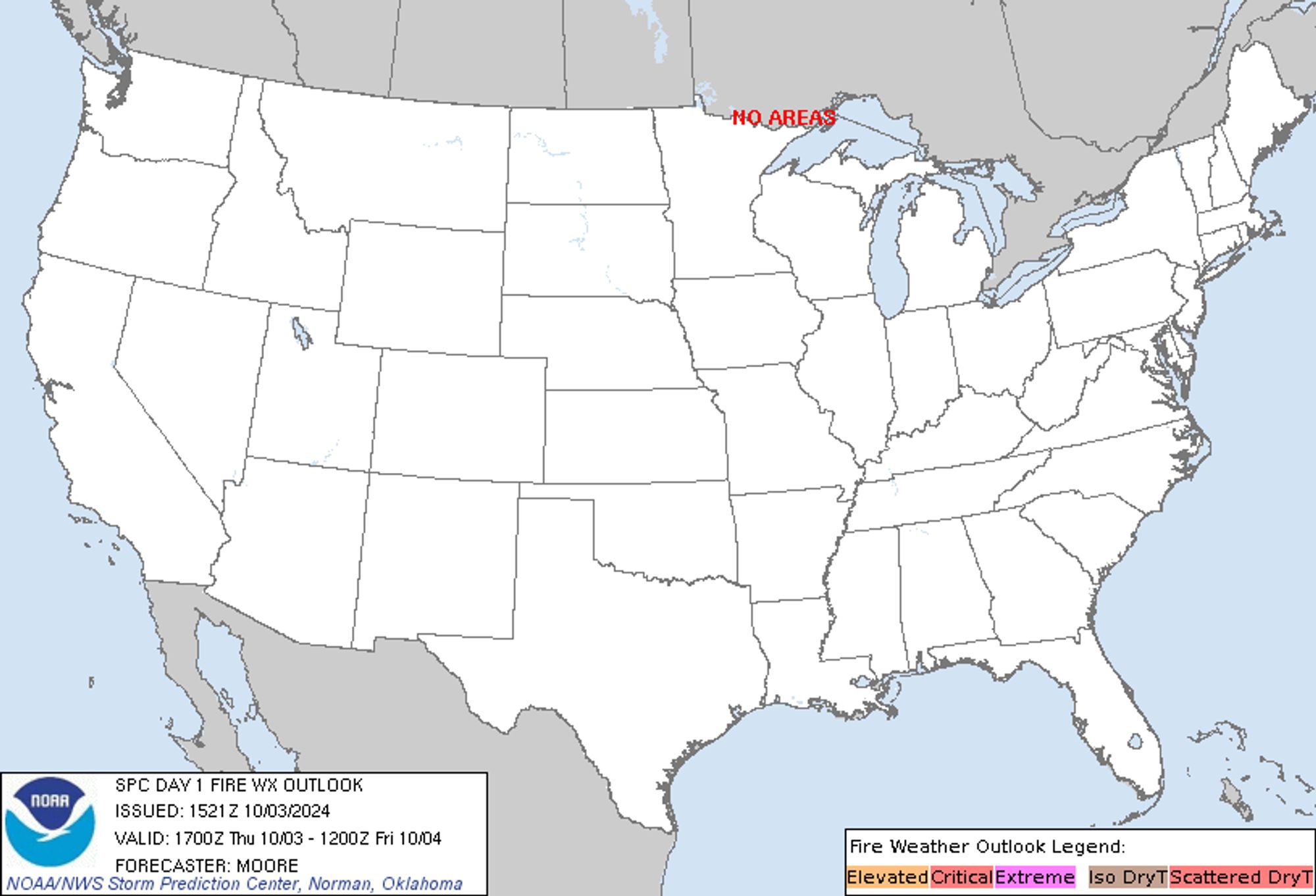
SPC Day 1 Fire Weather Outlook posted at Thu, 03 Oct 2024 15:22:28 +0000 🔥 /ISSUED 0217 AM CDT Thu Oct 03 2024/ 🔥 Additional Details Here.


Day 1 Fire Weather Outlook  
NWS Storm Prediction Center Norman OK
1021 AM CDT Thu Oct 03 2024

Valid 031700Z - 041200Z

The previous forecast remains on track. Consideration was made for
introducing a risk area to portions of central to northeast NE and
far northwest IA for this afternoon. Morning guidance continues to
show a strong signal for sustained 20-25 mph winds this afternoon
with the potential for gusts up to 30-35 mph. However, most 12 UTC
solutions, including several HREF members, are showing a pronounced
5-10 F warm bias across the central Plains based on 15 UTC
observations. Solutions that have captured recent
temperature/dewpoint trends well suggest RH will only fall to the
25-30% range by late afternoon. Consequently, confidence in
sustained elevated conditions remains very limited and precludes
risk highlights. 

Further south across the southern High Plains, elevated wind/RH
criteria will likely be met as winds increase on either side of a
surface trough. However, fuel dryness does not appear sufficient to
support a robust fire concern based on recent fuel guidance.

..Moore.. 10/03/2024

.PREV DISCUSSION... /ISSUED 0217 AM CDT Thu Oct 03 2024/

...Synopsis...
Shortwave ridging will traverse the western CONUS today. As this
occurs, high pressure will also build into the northern Plains. Some
breezy conditions are probable this afternoon in the wake of a cold
front across the central Plains. However, relative humidities will
not be that low (25-30 percent), and the strongest winds will likely
be displaced south of the driest fuels. Therefore, no Elevated area
is warranted today. However, warm and dry conditions will prevail
across most of the western CONUS and result in continued drying of
fuels.

...Please see www.spc.noaa.gov/fire for graphic product...
Day 1 Fire Weather Outlook Image
0

SF
SPC Fire Weather Outlooks Alerts (UNOFFICIAL)
@spc-fire.nws-bot.us
Unofficial bot sharing alerts from the NWS SPC Fire Weather Outlook. This account is not monitored. Contact @wandrme.paxex.aero if needed.
18 followers1 following44 posts