BLUE
SF
SPC Fire Weather Outlooks Alerts (UNOFFICIAL)
@spc-fire.nws-bot.us
Unofficial bot sharing alerts from the NWS SPC Fire Weather Outlook. This account is not monitored. Contact @wandrme.paxex.aero if needed.
17 followers1 following12 posts
SFspc-fire.nws-bot.us

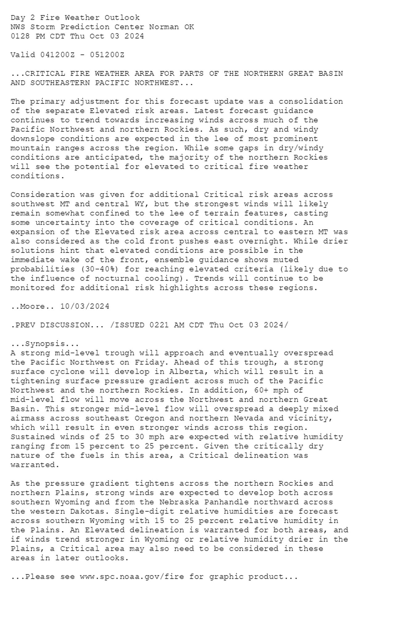
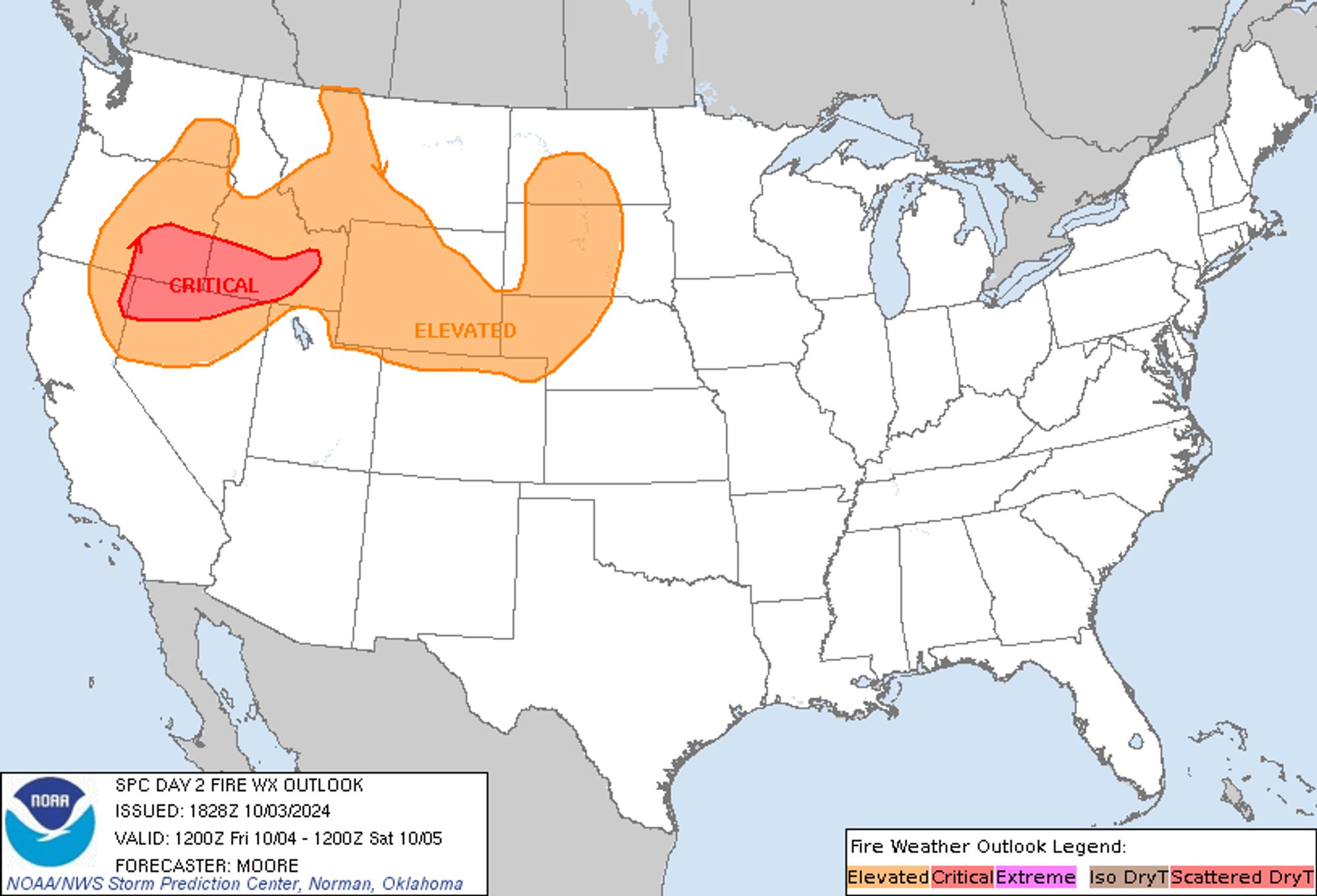
SPC Day 2 Fire Weather Outlook posted at Thu, 03 Oct 2024 18:29:27 +0000 🔥CRITICAL FIRE WEATHER AREA FOR PARTS OF THE NORTHERN GREAT BASIN AND SOUTHEASTERN PACIFIC NORTHWEST🔥 Additional Details Here.


Day 2 Fire Weather Outlook  
NWS Storm Prediction Center Norman OK
0128 PM CDT Thu Oct 03 2024

Valid 041200Z - 051200Z

...CRITICAL FIRE WEATHER AREA FOR PARTS OF THE NORTHERN GREAT BASIN
AND SOUTHEASTERN PACIFIC NORTHWEST...

The primary adjustment for this forecast update was a consolidation
of the separate Elevated risk areas. Latest forecast guidance
continues to trend towards increasing winds across much of the
Pacific Northwest and northern Rockies. As such, dry and windy
downslope conditions are expected in the lee of most prominent
mountain ranges across the region. While some gaps in dry/windy
conditions are anticipated, the majority of the northern Rockies
will see the potential for elevated to critical fire weather
conditions.

Consideration was given for additional Critical risk areas across
southwest MT and central WY, but the strongest winds will likely
remain somewhat confined to the lee of terrain features, casting
some uncertainty into the coverage of critical conditions. An
expansion of the Elevated risk area across central to eastern MT was
also considered as the cold front pushes east overnight. While drier
solutions hint that elevated conditions are possible in the
immediate wake of the front, ensemble guidance shows muted
probabilities (30-40%) for reaching elevated criteria (likely due to
the influence of nocturnal cooling). Trends will continue to be
monitored for additional risk highlights across these regions.

..Moore.. 10/03/2024

.PREV DISCUSSION... /ISSUED 0221 AM CDT Thu Oct 03 2024/

...Synopsis...
A strong mid-level trough will approach and eventually overspread
the Pacific Northwest on Friday. Ahead of this trough, a strong
surface cyclone will develop in Alberta, which will result in a
tightening surface pressure gradient across much of the Pacific
Northwest and the northern Rockies. In addition, 60+ mph of
mid-level flow will move across the Northwest and northern Great
Basin. This stronger mid-level flow will overspread a deeply mixed
airmass across southeast Oregon and northern Nevada and vicinity,
which will result in even stronger winds across this region.
Sustained winds of 25 to 30 mph are expected with relative humidity
ranging from 15 percent to 25 percent. Given the critically dry
nature of the fuels in this area, a Critical delineation was
warranted. 

As the pressure gradient tightens across the northern Rockies and
northern Plains, strong winds are expected to develop both across
southern Wyoming and from the Nebraska Panhandle northward across
the western Dakotas. Single-digit relative humidities are forecast
across southern Wyoming with 15 to 25 percent relative humidity in
the Plains. An Elevated delineation is warranted for both areas, and
if winds trend stronger in Wyoming or relative humidity drier in the
Plains, a Critical area may also need to be considered in these
areas in later outlooks.

...Please see www.spc.noaa.gov/fire for graphic product...
Day 2 Fire Weather Outlook Image
0

SF
SPC Fire Weather Outlooks Alerts (UNOFFICIAL)
@spc-fire.nws-bot.us
Unofficial bot sharing alerts from the NWS SPC Fire Weather Outlook. This account is not monitored. Contact @wandrme.paxex.aero if needed.
17 followers1 following12 posts