BLUE
AF
Alerts from NWS Rapid City SD (UNOFFICIAL)
@unr.nws-bot.us
Unofficial bot sharing alerts from NWS Rapid City SD. This account is not monitored. Contact @wandrme.paxex.aero if needed.
72 followers1 following75 posts
AFunr.nws-bot.us

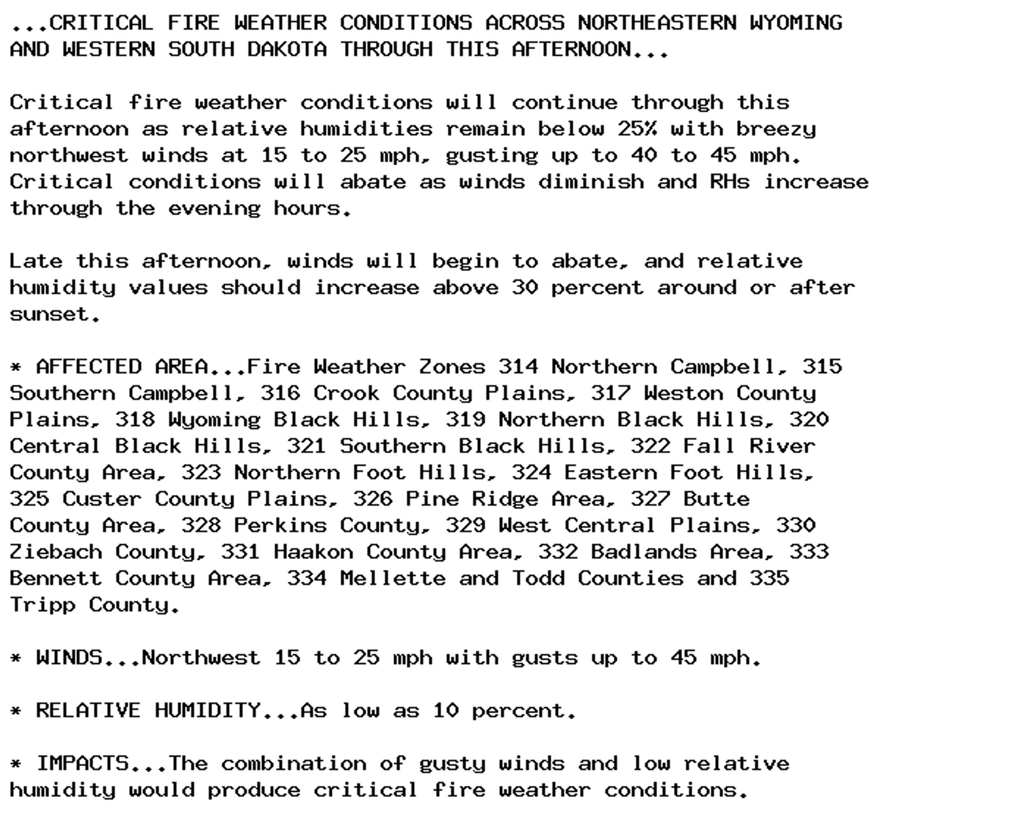
🚨 Red Flag Warning issued October 5 at 1:53PM MDT until October 5 at 6:00PM MDT by NWS Rapid City SD 🚨 Additional Details Here.

...CRITICAL FIRE WEATHER CONDITIONS ACROSS NORTHEASTERN WYOMING
AND WESTERN SOUTH DAKOTA THROUGH THIS AFTERNOON...

Critical fire weather conditions will continue through this
afternoon as relative humidities remain below 25% with breezy
northwest winds at 15 to 25 mph, gusting up to 40 to 45 mph.
Critical conditions will abate as winds diminish and RHs increase
through the evening hours.

Late this afternoon, winds will begin to abate, and relative
humidity values should increase above 30 percent around or after
sunset.

* AFFECTED AREA...Fire Weather Zones 314 Northern Campbell, 315
Southern Campbell, 316 Crook County Plains, 317 Weston County
Plains, 318 Wyoming Black Hills, 319 Northern Black Hills, 320
Central Black Hills, 321 Southern Black Hills, 322 Fall River
County Area, 323 Northern Foot Hills, 324 Eastern Foot Hills,
325 Custer County Plains, 326 Pine Ridge Area, 327 Butte
County Area, 328 Perkins County, 329 West Central Plains, 330
Ziebach County, 331 Haakon County Area, 332 Badlands Area, 333
Bennett County Area, 334 Mellette and Todd Counties and 335
Tripp County.

* WINDS...Northwest 15 to 25 mph with gusts up to 45 mph.

* RELATIVE HUMIDITY...As low as 10 percent.

* IMPACTS...The combination of gusty winds and low relative
humidity would produce critical fire weather conditions.
0

AF
Alerts from NWS Rapid City SD (UNOFFICIAL)
@unr.nws-bot.us
Unofficial bot sharing alerts from NWS Rapid City SD. This account is not monitored. Contact @wandrme.paxex.aero if needed.
72 followers1 following75 posts