BLUE
WMomega7stone.bsky.social

Lightweight. I once went on a beer run from Hillsboro lighthouse during a storm that was so rough, I couldn't ride my bike across the bridge.

0
AFmia.nws-bot.us

Marine Weather Statement issued October 6 at 4:31PM EDT by NWS Miami FL Additional Details Here.

The areas affected include...
Biscayne Bay...
Coastal waters from Deerfield Beach to Ocean Reef FL out 20 NM...
Coastal waters from Jupiter Inlet to Deerfield Beach FL out 20
NM...
Waters from Deerfield Beach to Ocean Reef FL from 20 to 60 NM
excluding the territorial waters of Bahamas...
Waters from Jupiter Inlet to Deerfield Beach FL from 20 to 60
NM...

At 431 PM EDT, Doppler radar indicated a strong thunderstorm, capable
of producing winds to around 30 knots. This thunderstorm was located
31 nm east of Hillsboro Beach, or 31 nm east of
Lauderdale-By-The-Sea, moving north at 10 knots.
0
AFmia.nws-bot.us

Marine Weather Statement issued October 6 at 3:33PM EDT by NWS Miami FL Additional Details Here.

The areas affected include...
Biscayne Bay...
Coastal waters from Deerfield Beach to Ocean Reef FL out 20 NM...
Coastal waters from Jupiter Inlet to Deerfield Beach FL out 20
NM...
Waters from Deerfield Beach to Ocean Reef FL from 20 to 60 NM
excluding the territorial waters of Bahamas...
Waters from Jupiter Inlet to Deerfield Beach FL from 20 to 60
NM...

At 333 PM EDT, Doppler radar indicated showers, capable of producing
winds to around 30 knots. These showers are located 33 nm east of
Hillsboro Beach, or 33 nm east of Lighthouse Point. The showers are
nearly stationary.
0
AFmia.nws-bot.us

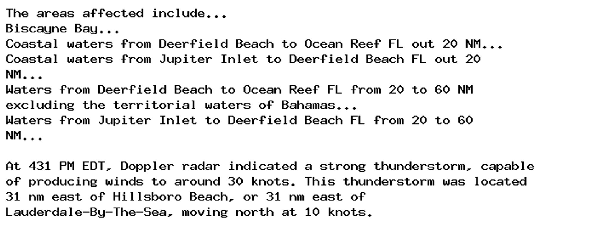
🚨 Special Marine Warning issued October 6 at 3:41PM EDT until October 6 at 4:15PM EDT by NWS Miami FL 🚨 Additional Details Here.

SMWMFL

The National Weather Service in Miami has issued a

* Special Marine Warning for...
Waters from Deerfield Beach to Ocean Reef FL from 20 to 60 NM
excluding the territorial waters of Bahamas...
Waters from Jupiter Inlet to Deerfield Beach FL from 20 to 60 NM...

* Until 415 PM EDT.

* At 341 PM EDT, a severe thunderstorm capable of producing
waterspouts was located 33 nm east of Hillsboro Beach, or 34 nm
east of Lighthouse Point. The severe thunderstorm was nearly
stationary.

HAZARD...Waterspouts and wind gusts 34 knots or greater.

SOURCE...Radar.

IMPACT...Waterspouts can easily overturn boats and create locally
hazardous seas. Small craft could be damaged in briefly
higher winds and suddenly higher waves.

* The severe thunderstorm will remain over mainly open waters.
0
Ccartoonrecruit.com

At ease, recruits! Laika is currently searching for a VFX Assistant Editor in #Hillsboro. Interested? Apply here:

0

I reposted something on Instagram from Don't Rank Rene and a hillsboro resident replied "boo" I just responded "which one of us gets to vote in this election again?"

2
AFmia.nws-bot.us

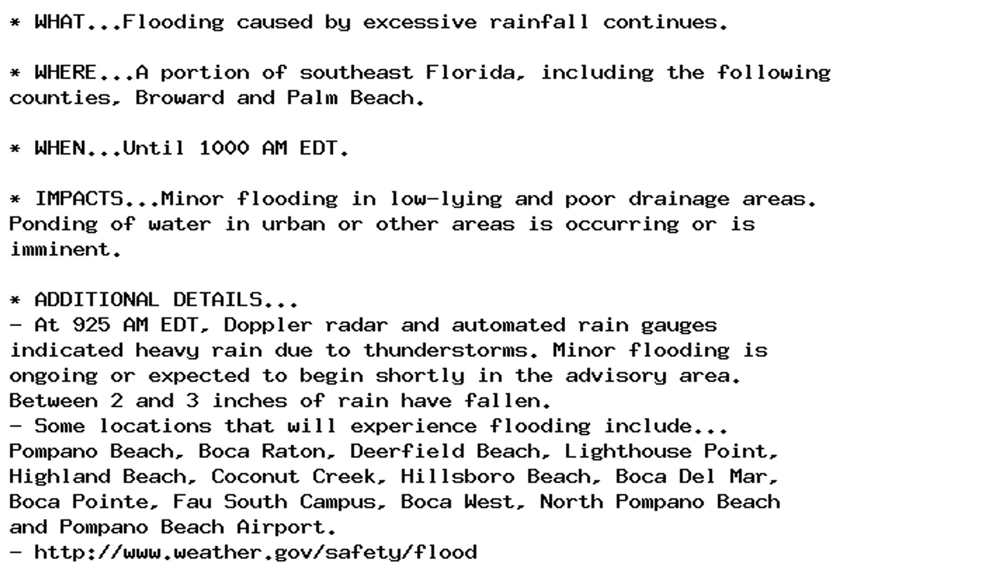
Flood Advisory issued October 4 at 9:25AM EDT until October 4 at 10:00AM EDT by NWS Miami FL Additional Details Here.

* WHAT...Flooding caused by excessive rainfall continues.

* WHERE...A portion of southeast Florida, including the following
counties, Broward and Palm Beach.

* WHEN...Until 1000 AM EDT.

* IMPACTS...Minor flooding in low-lying and poor drainage areas.
Ponding of water in urban or other areas is occurring or is
imminent.

* ADDITIONAL DETAILS...
- At 925 AM EDT, Doppler radar and automated rain gauges
indicated heavy rain due to thunderstorms. Minor flooding is
ongoing or expected to begin shortly in the advisory area.
Between 2 and 3 inches of rain have fallen.
- Some locations that will experience flooding include...
Pompano Beach, Boca Raton, Deerfield Beach, Lighthouse Point,
Highland Beach, Coconut Creek, Hillsboro Beach, Boca Del Mar,
Boca Pointe, Fau South Campus, Boca West, North Pompano Beach
and Pompano Beach Airport.
- http://www.weather.gov/safety/flood
0
AFmia.nws-bot.us

Flood Advisory issued October 4 at 8:46AM EDT until October 4 at 10:00AM EDT by NWS Miami FL Additional Details Here.

* WHAT...Flooding caused by excessive rainfall continues.

* WHERE...A portion of southeast Florida, including the following
counties, Broward and Palm Beach.

* WHEN...Until 1000 AM EDT.

* IMPACTS...Minor flooding in low-lying and poor drainage areas.
Ponding of water in urban or other areas is occurring or is
imminent.

* ADDITIONAL DETAILS...
- At 846 AM EDT, Doppler radar and automated rain gauges
indicated heavy rain due to thunderstorms. Minor flooding is
ongoing or expected to begin shortly in the advisory area.
Between 1.5 and 2.5 inches of rain have fallen.
- Additional rainfall amounts up to 1 inch are expected over
the area. This additional rain will result in minor flooding.
- Some locations that will experience flooding include...
Pompano Beach, Boca Raton, Deerfield Beach, Lighthouse Point,
Highland Beach, Coconut Creek, Hillsboro Beach, Boca Del Mar,
Boca Pointe, Fau South Campus, Boca West, North Pompano Beach
and Pompano Beach Airport.
- http://www.weather.gov/safety/flood
0
AFmia.nws-bot.us

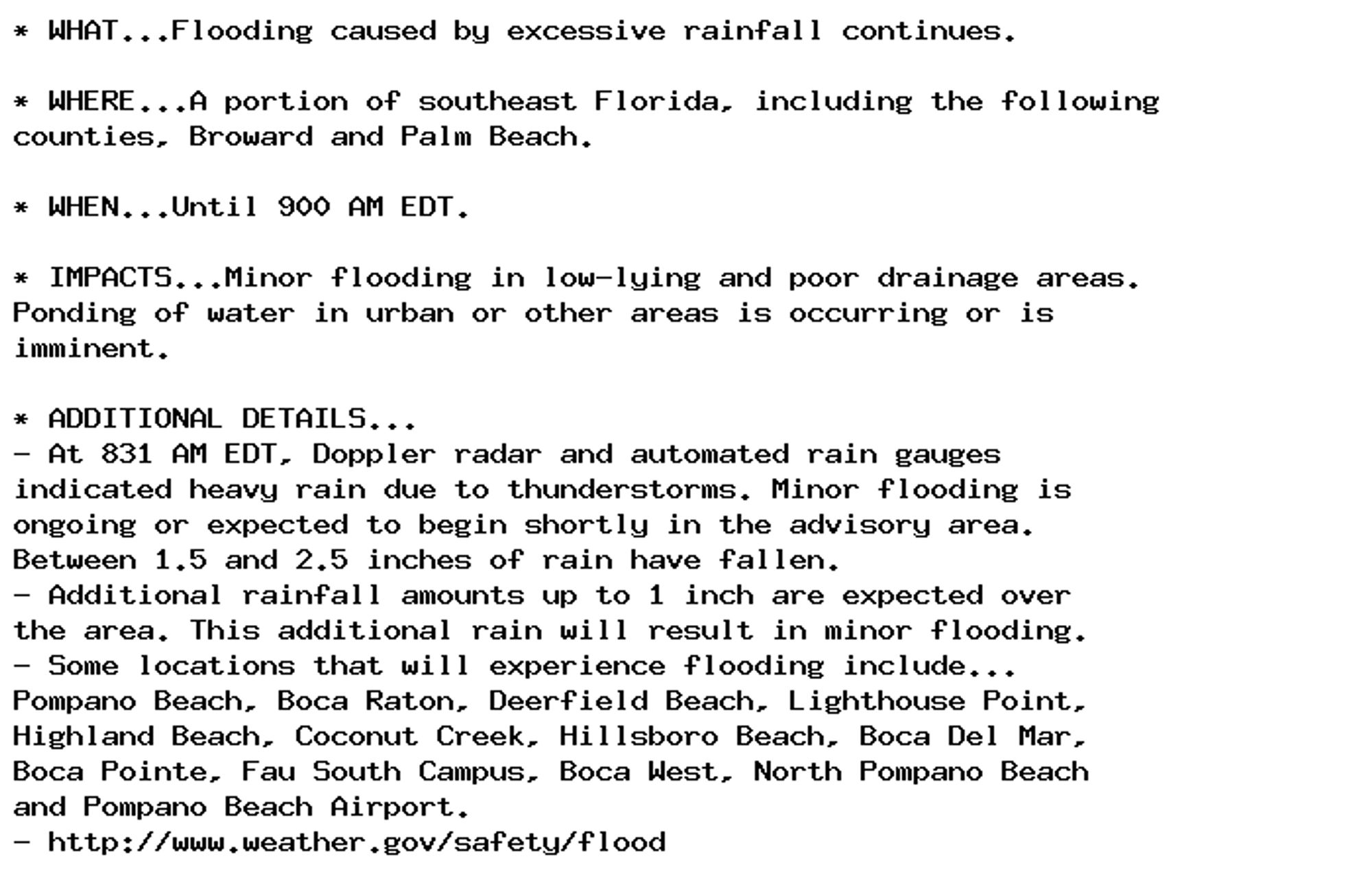
Flood Advisory issued October 4 at 8:31AM EDT until October 4 at 9:00AM EDT by NWS Miami FL Additional Details Here.

* WHAT...Flooding caused by excessive rainfall continues.

* WHERE...A portion of southeast Florida, including the following
counties, Broward and Palm Beach.

* WHEN...Until 900 AM EDT.

* IMPACTS...Minor flooding in low-lying and poor drainage areas.
Ponding of water in urban or other areas is occurring or is
imminent.

* ADDITIONAL DETAILS...
- At 831 AM EDT, Doppler radar and automated rain gauges
indicated heavy rain due to thunderstorms. Minor flooding is
ongoing or expected to begin shortly in the advisory area.
Between 1.5 and 2.5 inches of rain have fallen.
- Additional rainfall amounts up to 1 inch are expected over
the area. This additional rain will result in minor flooding.
- Some locations that will experience flooding include...
Pompano Beach, Boca Raton, Deerfield Beach, Lighthouse Point,
Highland Beach, Coconut Creek, Hillsboro Beach, Boca Del Mar,
Boca Pointe, Fau South Campus, Boca West, North Pompano Beach
and Pompano Beach Airport.
- http://www.weather.gov/safety/flood
0
AFmia.nws-bot.us

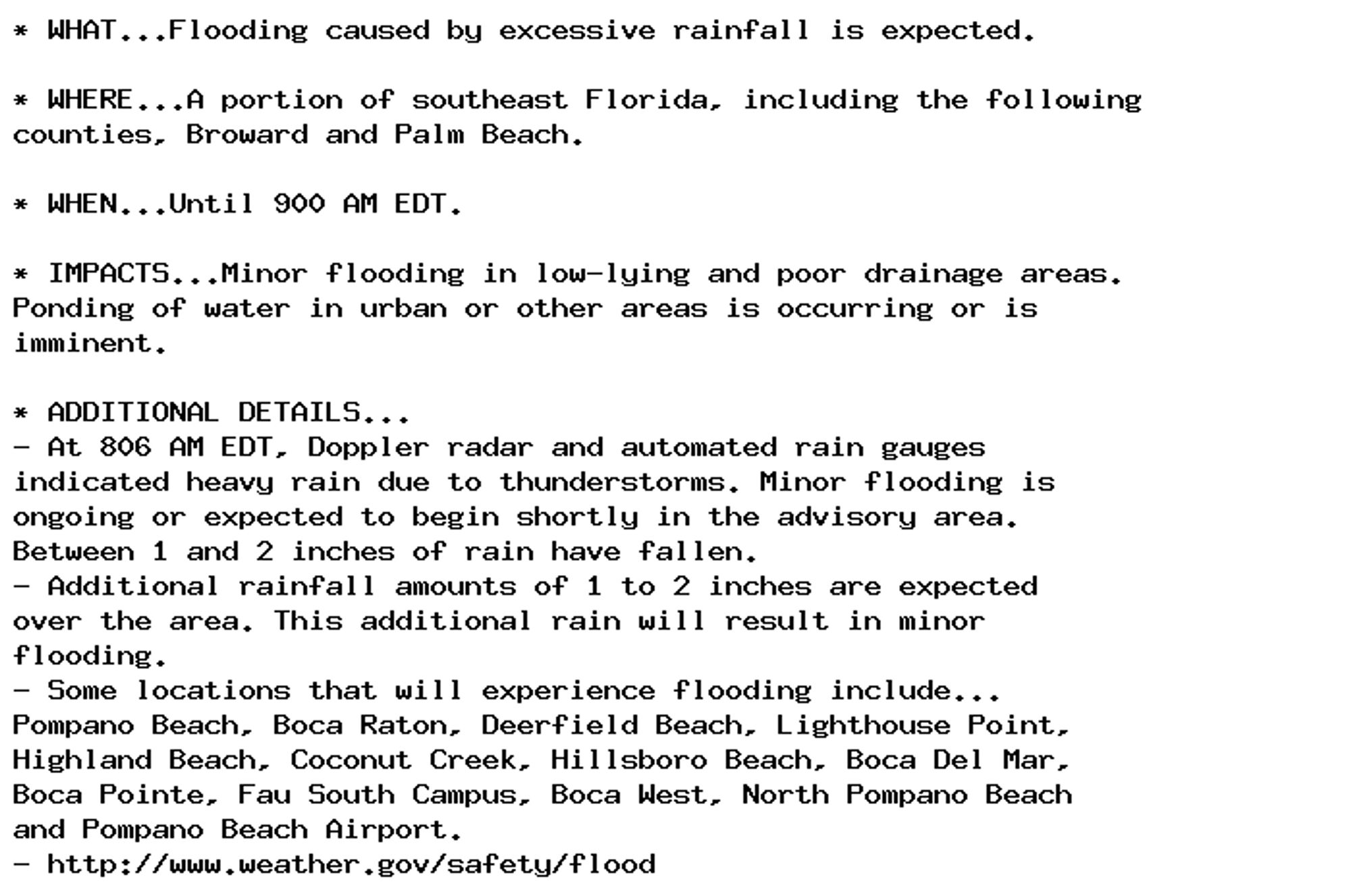
Flood Advisory issued October 4 at 8:06AM EDT until October 4 at 9:00AM EDT by NWS Miami FL Additional Details Here.

* WHAT...Flooding caused by excessive rainfall is expected.

* WHERE...A portion of southeast Florida, including the following
counties, Broward and Palm Beach.

* WHEN...Until 900 AM EDT.

* IMPACTS...Minor flooding in low-lying and poor drainage areas.
Ponding of water in urban or other areas is occurring or is
imminent.

* ADDITIONAL DETAILS...
- At 806 AM EDT, Doppler radar and automated rain gauges
indicated heavy rain due to thunderstorms. Minor flooding is
ongoing or expected to begin shortly in the advisory area.
Between 1 and 2 inches of rain have fallen.
- Additional rainfall amounts of 1 to 2 inches are expected
over the area. This additional rain will result in minor
flooding.
- Some locations that will experience flooding include...
Pompano Beach, Boca Raton, Deerfield Beach, Lighthouse Point,
Highland Beach, Coconut Creek, Hillsboro Beach, Boca Del Mar,
Boca Pointe, Fau South Campus, Boca West, North Pompano Beach
and Pompano Beach Airport.
- http://www.weather.gov/safety/flood
0