BLUE
ariko23marz.bsky.social

02 Oct., 2024 ⚾️ The last game of this season. Congratulations!!!🏆️✨

0
Llangley127.bsky.social

🇨🇳 Fan Yuhao stabbed three 5-year-old kids in Zurich on 1st Oct.,2024. He’s studying for a master’s degree in computational linguistics at the University of Zurich. Fan’s posts on Instagram indicate that he’s a Chinese nationalist. www.instagram.com/yuhfswu/linkedin.com/in/yuhao-fan...

0
Pwoskethoughts.bsky.social

Bluesky now has over 10 million users, and I was #1,726,558!

A virtual certificate with text "Celebrating 10M users on Bluesky, #1,726,558, Plen Gowell ‪@woskethoughts.bsky.social‬, joined on Oct 26, 2023"
0
NHnhc-epac.nws-bot.us

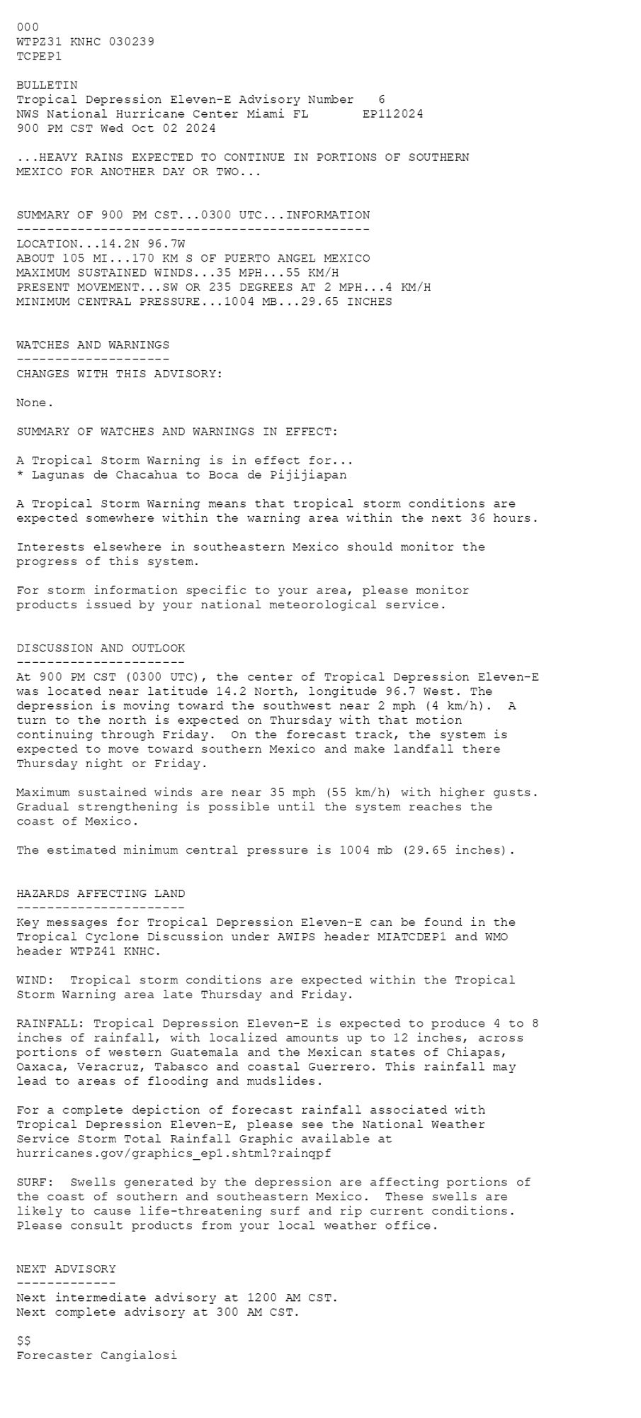
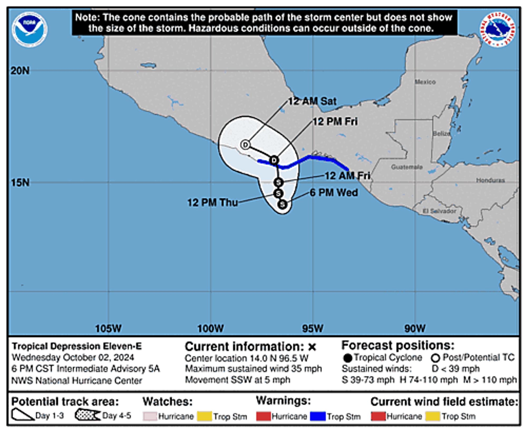
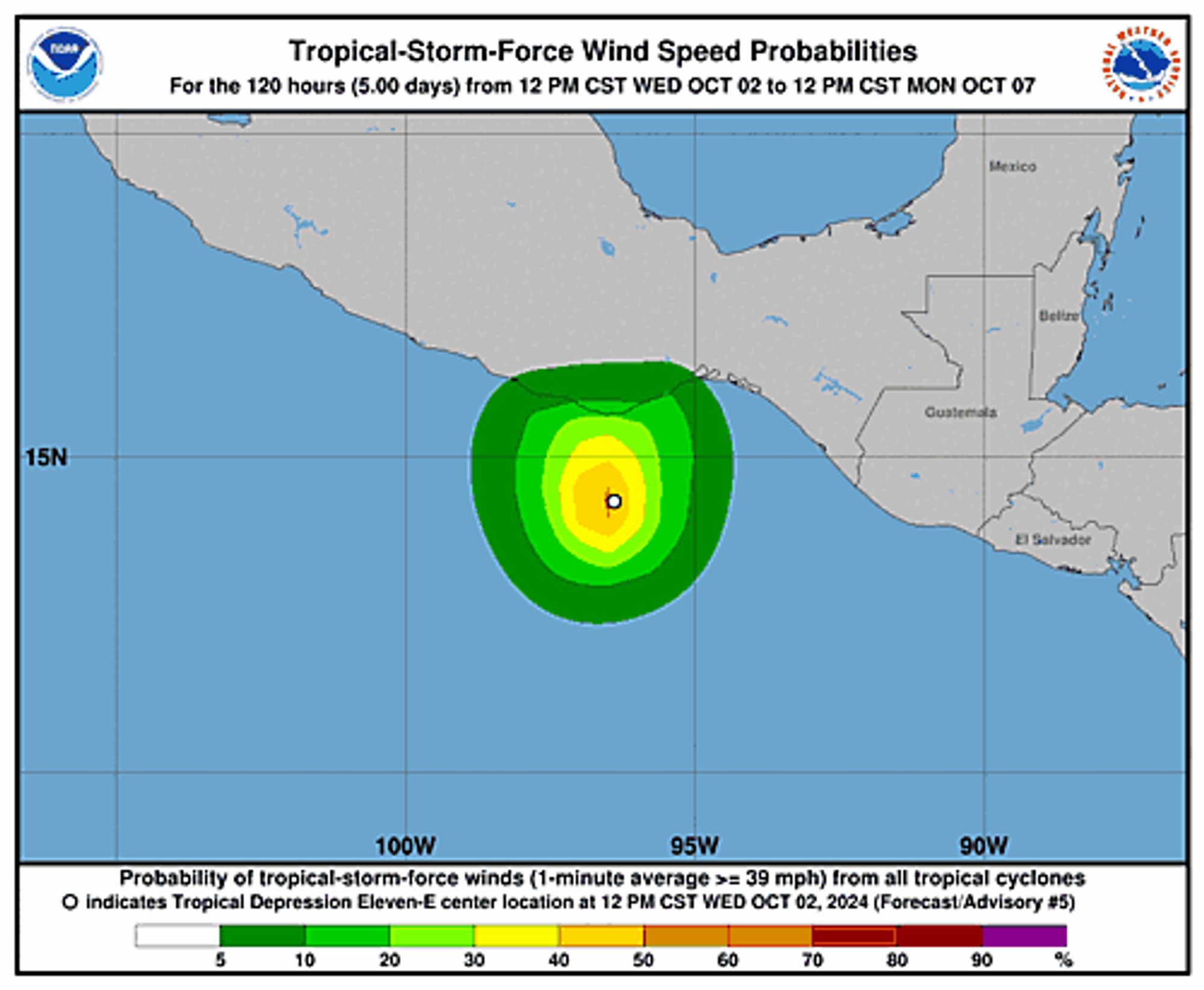
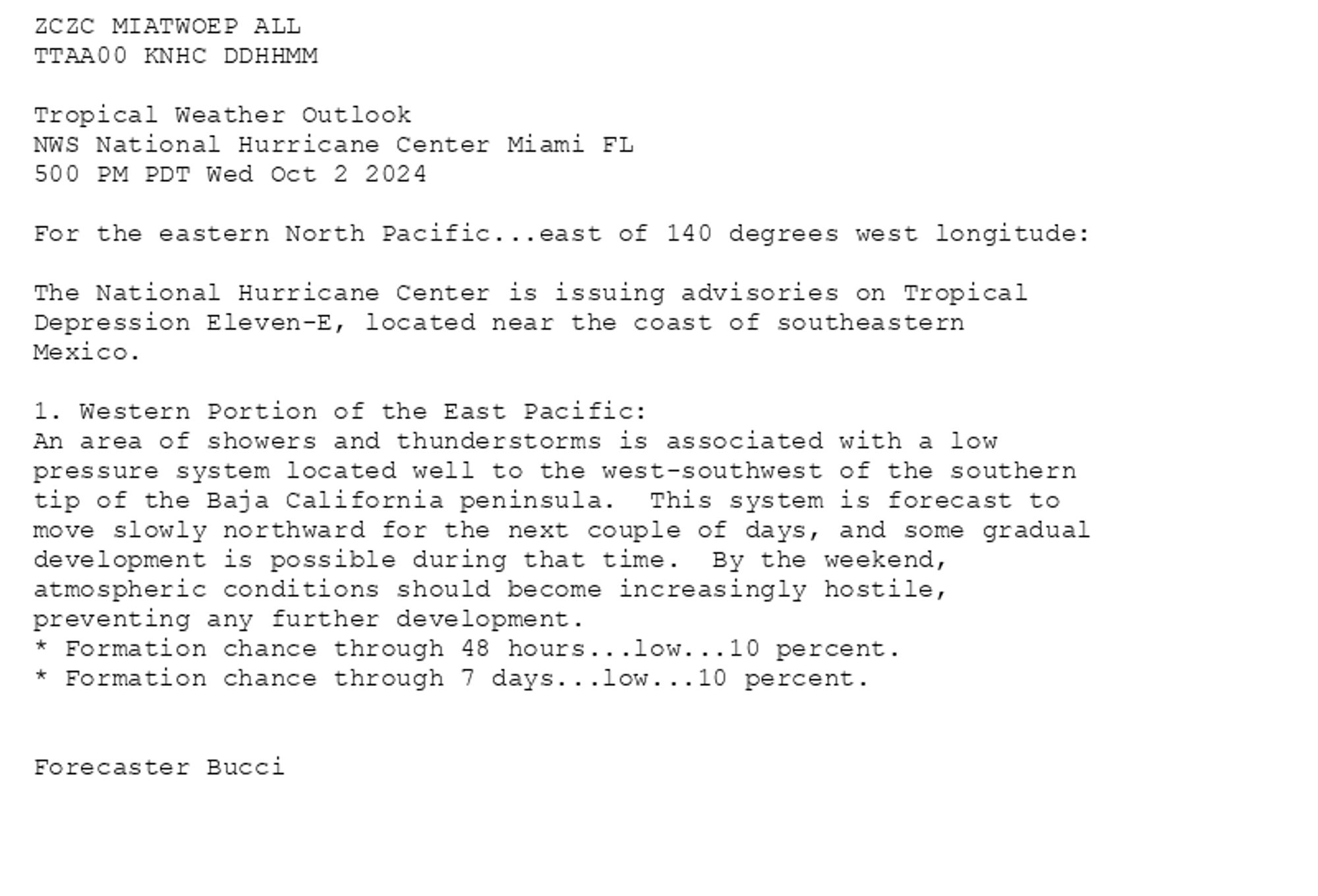
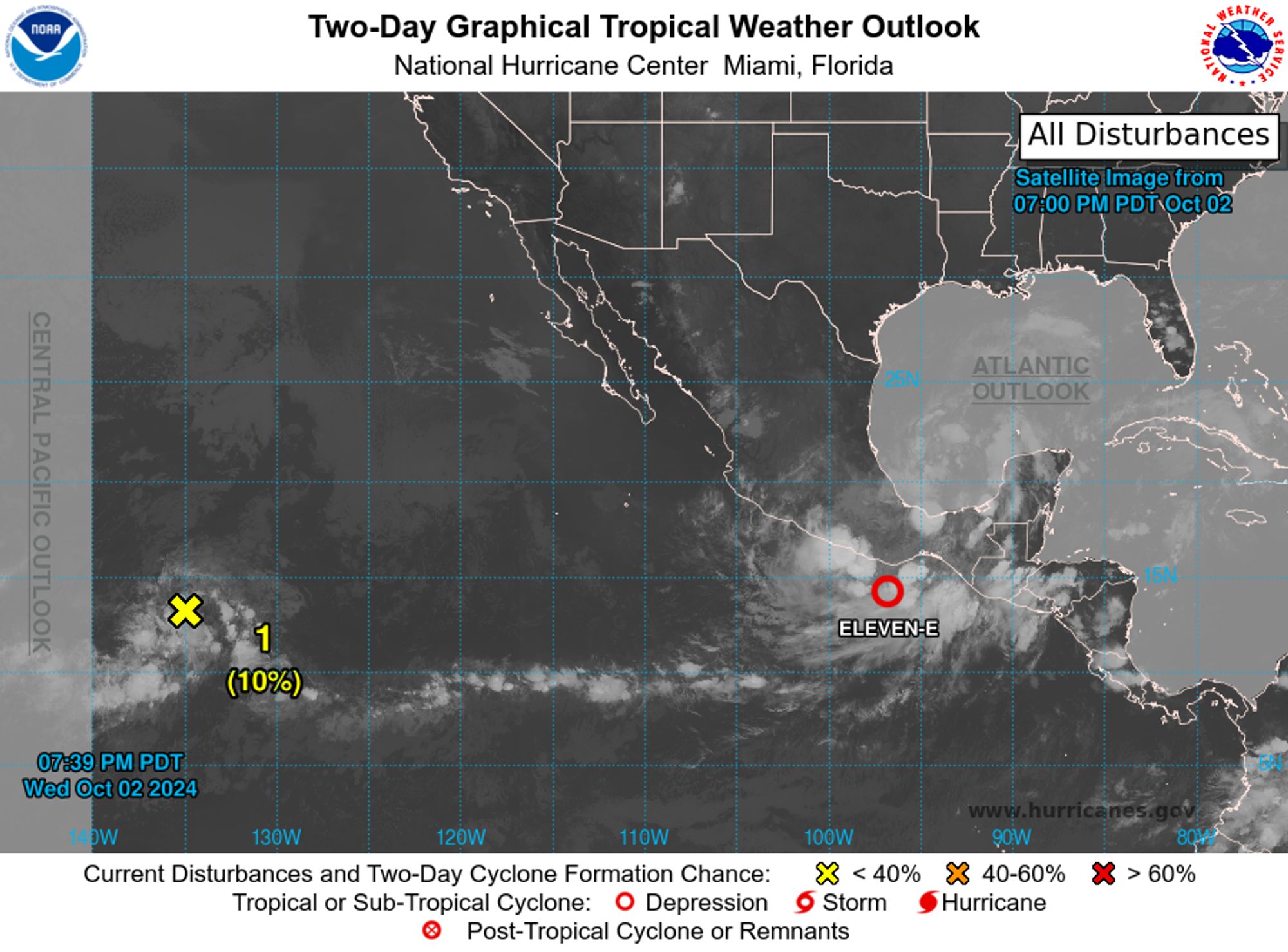
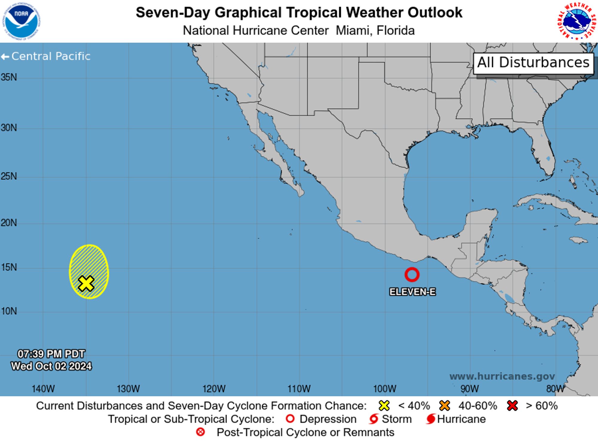
Eastern Pacific Tropical Depression Eleven-E Advisory Number 6 issued at Thu, 03 Oct 2024 02:39:10 +0000 ...HEAVY RAINS EXPECTED TO CONTINUE IN PORTIONS OF SOUTHERN MEXICO FOR ANOTHER DAY OR TWO... Additional Details Here.


 <br />
 000<br />
 WTPZ31 KNHC 030239<br />
 TCPEP1<br />
  <br />
 BULLETIN<br />
 Tropical Depression Eleven-E Advisory Number   6<br />
 NWS National Hurricane Center Miami FL       EP112024<br />
 900 PM CST Wed Oct 02 2024<br />
  <br />
 ...HEAVY RAINS EXPECTED TO CONTINUE IN PORTIONS OF SOUTHERN<br />
 MEXICO FOR ANOTHER DAY OR TWO...<br />
  <br />
  <br />
 SUMMARY OF 900 PM CST...0300 UTC...INFORMATION<br />
 ----------------------------------------------<br />
 LOCATION...14.2N 96.7W<br />
 ABOUT 105 MI...170 KM S OF PUERTO ANGEL MEXICO<br />
 MAXIMUM SUSTAINED WINDS...35 MPH...55 KM/H<br />
 PRESENT MOVEMENT...SW OR 235 DEGREES AT 2 MPH...4 KM/H<br />
 MINIMUM CENTRAL PRESSURE...1004 MB...29.65 INCHES<br />
  <br />
  <br />
 WATCHES AND WARNINGS<br />
 --------------------<br />
 CHANGES WITH THIS ADVISORY:<br />
  <br />
 None.<br />
  <br />
 SUMMARY OF WATCHES AND WARNINGS IN EFFECT:<br />
  <br />
 A Tropical Storm Warning is in effect for...<br />
 * Lagunas de Chacahua to Boca de Pijijiapan<br />
  <br />
 A Tropical Storm Warning means that tropical storm conditions are<br />
 expected somewhere within the warning area within the next 36 hours.<br />
  <br />
 Interests elsewhere in southeastern Mexico should monitor the<br />
 progress of this system.<br />
  <br />
 For storm information specific to your area, please monitor<br />
 products issued by your national meteorological service.<br />
  <br />
  <br />
 DISCUSSION AND OUTLOOK<br />
 ----------------------<br />
 At 900 PM CST (0300 UTC), the center of Tropical Depression Eleven-E<br />
 was located near latitude 14.2 North, longitude 96.7 West. The<br />
 depression is moving toward the southwest near 2 mph (4 km/h).  A <br />
 turn to the north is expected on Thursday with that motion <br />
 continuing through Friday.  On the forecast track, the system is <br />
 expected to move toward southern Mexico and make landfall there <br />
 Thursday night or Friday.<br />
 <br />
 Maximum sustained winds are near 35 mph (55 km/h) with higher gusts.<br />
 Gradual strengthening is possible until the system reaches the <br />
 coast of Mexico.<br />
  <br />
 The estimated minimum central pressure is 1004 mb (29.65 inches).<br />
  <br />
  <br />
 HAZARDS AFFECTING LAND<br />
 ----------------------<br />
 Key messages for Tropical Depression Eleven-E can be found in the<br />
 Tropical Cyclone Discussion under AWIPS header MIATCDEP1 and WMO<br />
 header WTPZ41 KNHC.<br />
  <br />
 WIND:  Tropical storm conditions are expected within the Tropical<br />
 Storm Warning area late Thursday and Friday.<br />
  <br />
 RAINFALL: Tropical Depression Eleven-E is expected to produce 4 to 8<br />
 inches of rainfall, with localized amounts up to 12 inches, across<br />
 portions of western Guatemala and the Mexican states of Chiapas,<br />
 Oaxaca, Veracruz, Tabasco and coastal Guerrero. This rainfall may<br />
 lead to areas of flooding and mudslides.<br />
  <br />
 For a complete depiction of forecast rainfall associated with<br />
 Tropical Depression Eleven-E, please see the National Weather<br />
 Service Storm Total Rainfall Graphic available at<br />
 hurricanes.gov/graphics_ep1.shtml?rainqpf<br />
  <br />
 SURF:  Swells generated by the depression are affecting portions of<br />
 the coast of southern and southeastern Mexico.  These swells are<br />
 likely to cause life-threatening surf and rip current conditions.<br />
 Please consult products from your local weather office.<br />
  <br />
  <br />
 NEXT ADVISORY<br />
 -------------<br />
 Next intermediate advisory at 1200 AM CST.<br />
 Next complete advisory at 300 AM CST.<br />
  <br />
 $$<br />
 Forecaster Cangialosi<br />
  <br />
Tropical Depression Eleven-E 5-Day Uncertainty Track Image
Tropical Depression Eleven-E 34-Knot Wind Speed Probabilities
0
NHnhc-atlc.nws-bot.us

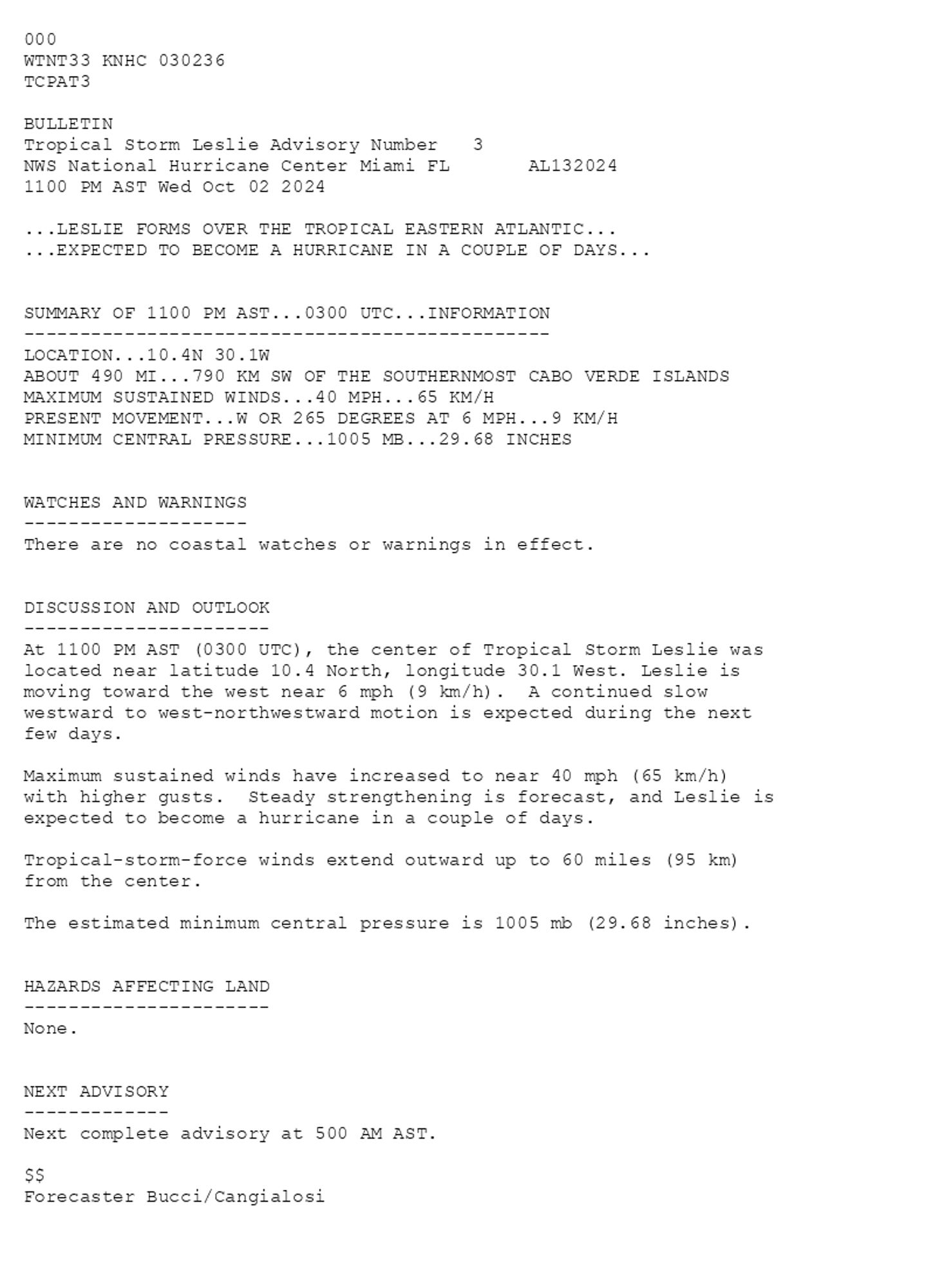
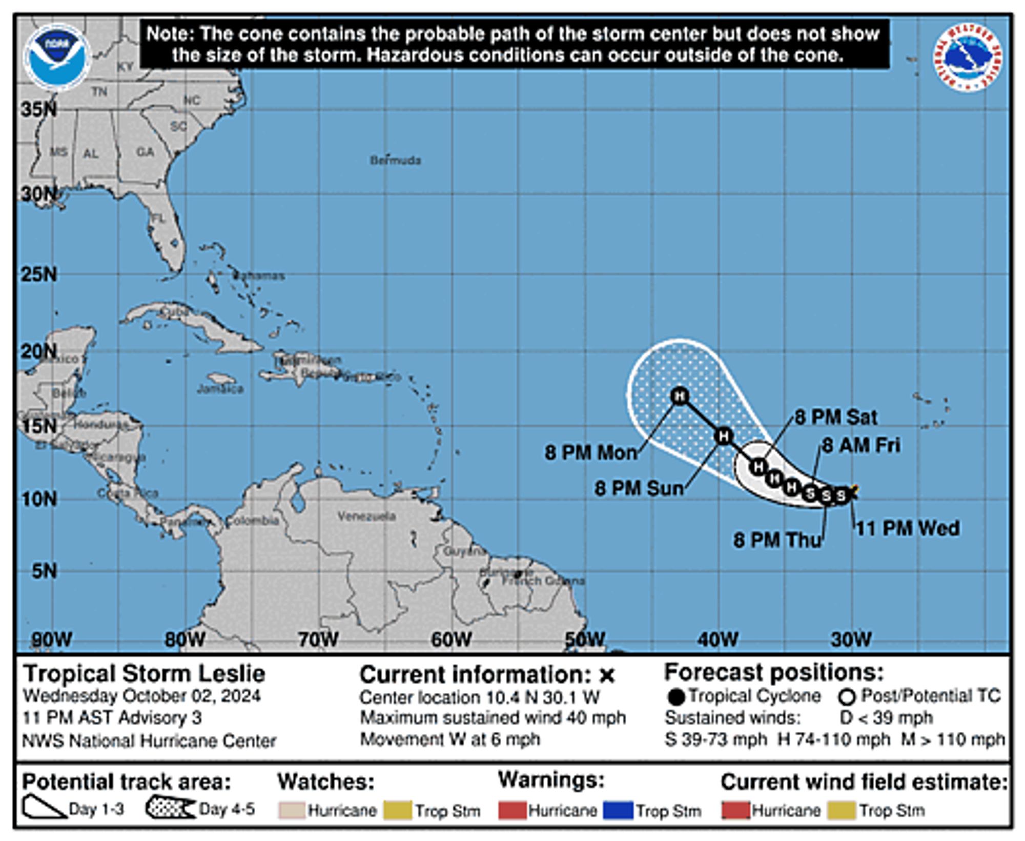
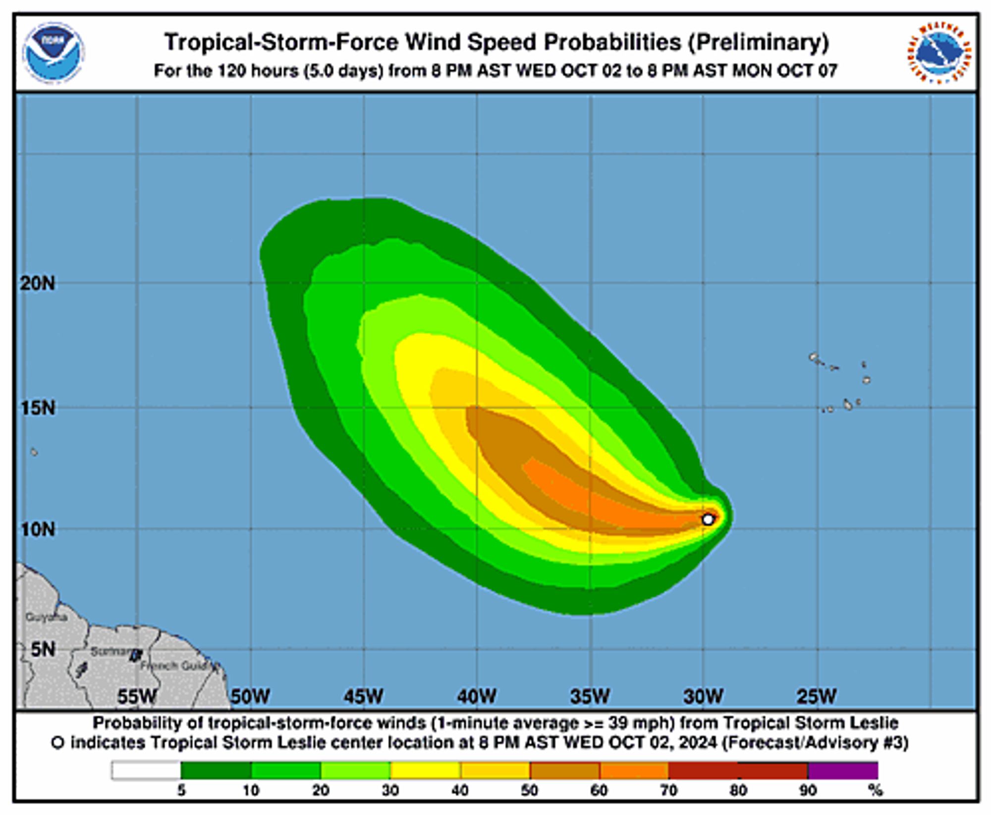
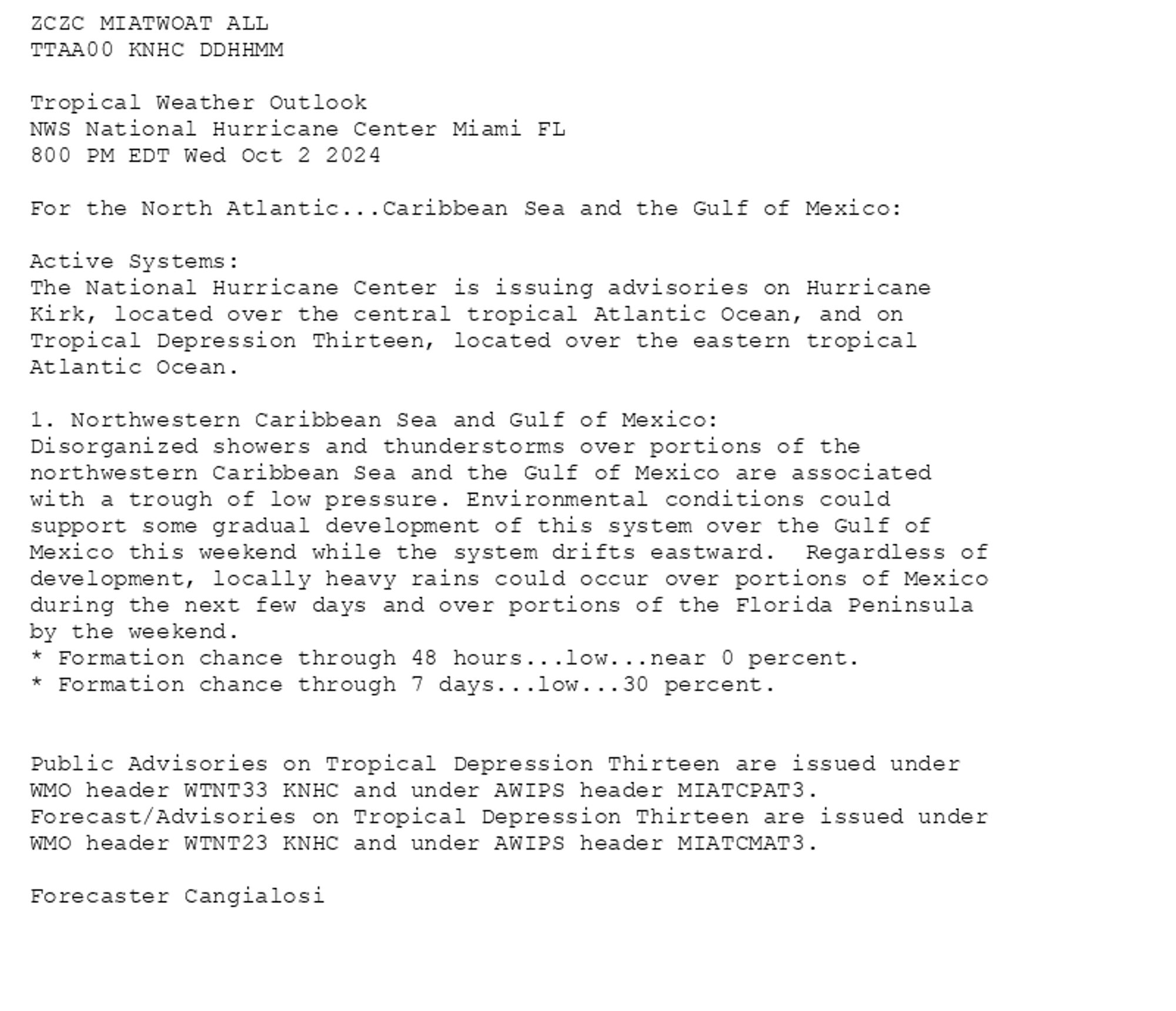
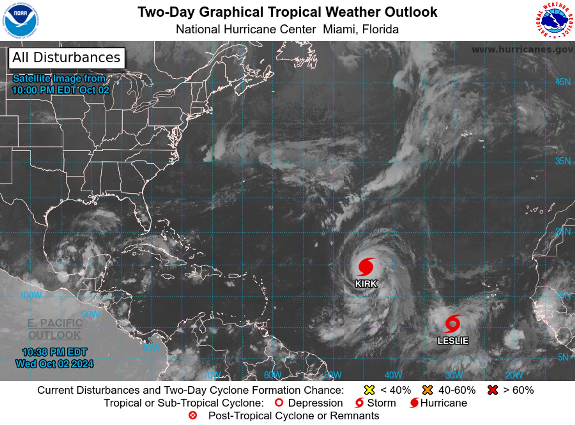
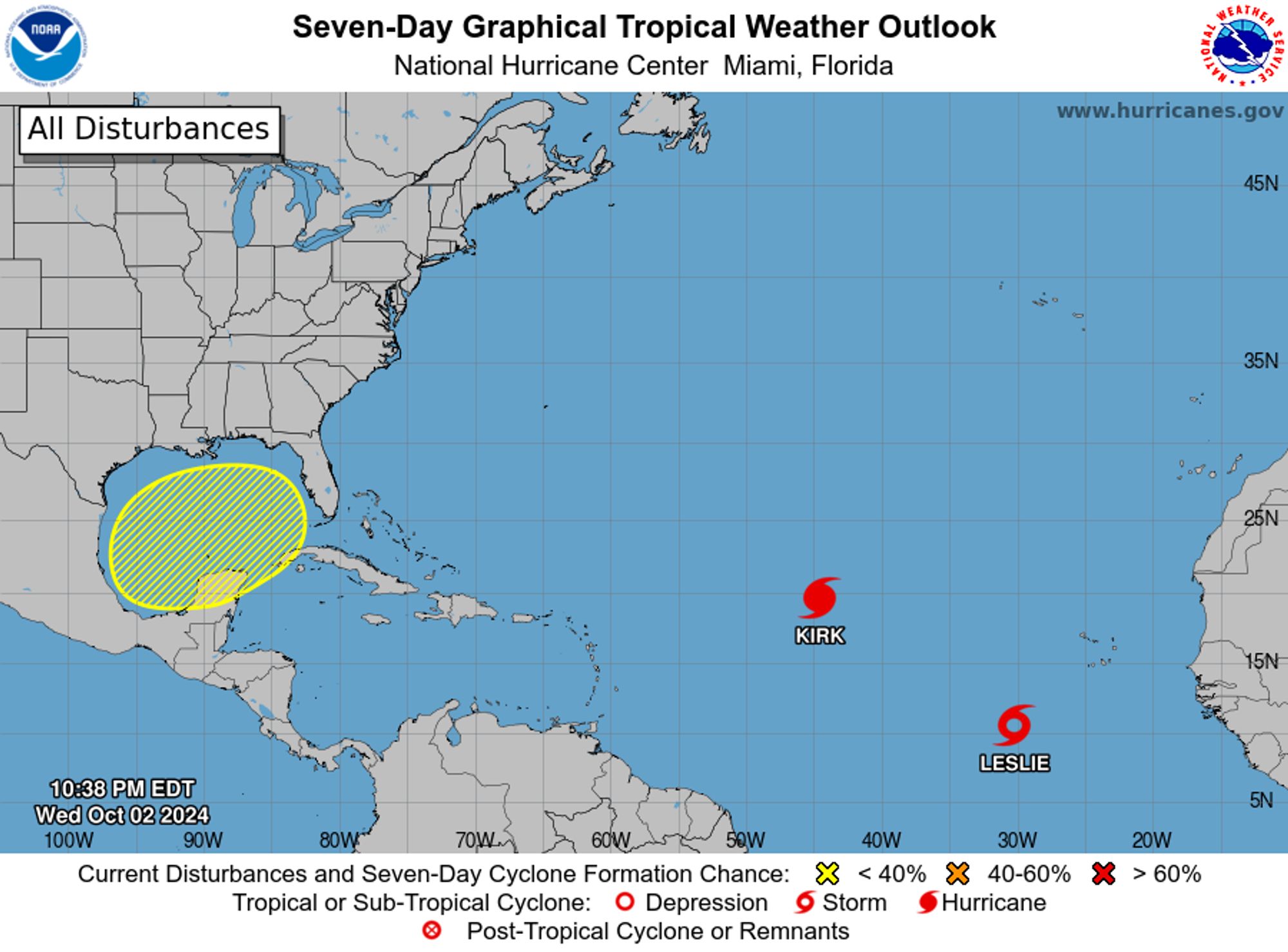
Atlantic Tropical Storm Leslie Advisory Number 3 issued at Thu, 03 Oct 2024 02:36:10 +0000 ...LESLIE FORMS OVER THE TROPICAL EASTERN ATLANTIC... ...EXPECTED TO BECOME A HURRICANE IN A COUPLE OF DAYS... Additional Details Here.


 <br />
 000<br />
 WTNT33 KNHC 030236<br />
 TCPAT3<br />
  <br />
 BULLETIN<br />
 Tropical Storm Leslie Advisory Number   3<br />
 NWS National Hurricane Center Miami FL       AL132024<br />
 1100 PM AST Wed Oct 02 2024<br />
  <br />
 ...LESLIE FORMS OVER THE TROPICAL EASTERN ATLANTIC...<br />
 ...EXPECTED TO BECOME A HURRICANE IN A COUPLE OF DAYS...<br />
  <br />
  <br />
 SUMMARY OF 1100 PM AST...0300 UTC...INFORMATION<br />
 -----------------------------------------------<br />
 LOCATION...10.4N 30.1W<br />
 ABOUT 490 MI...790 KM SW OF THE SOUTHERNMOST CABO VERDE ISLANDS<br />
 MAXIMUM SUSTAINED WINDS...40 MPH...65 KM/H<br />
 PRESENT MOVEMENT...W OR 265 DEGREES AT 6 MPH...9 KM/H<br />
 MINIMUM CENTRAL PRESSURE...1005 MB...29.68 INCHES<br />
  <br />
  <br />
 WATCHES AND WARNINGS<br />
 --------------------<br />
 There are no coastal watches or warnings in effect.<br />
  <br />
  <br />
 DISCUSSION AND OUTLOOK<br />
 ----------------------<br />
 At 1100 PM AST (0300 UTC), the center of Tropical Storm Leslie was<br />
 located near latitude 10.4 North, longitude 30.1 West. Leslie is<br />
 moving toward the west near 6 mph (9 km/h).  A continued slow <br />
 westward to west-northwestward motion is expected during the next <br />
 few days.<br />
  <br />
 Maximum sustained winds have increased to near 40 mph (65 km/h) <br />
 with higher gusts.  Steady strengthening is forecast, and Leslie is <br />
 expected to become a hurricane in a couple of days.<br />
  <br />
 Tropical-storm-force winds extend outward up to 60 miles (95 km)<br />
 from the center.<br />
  <br />
 The estimated minimum central pressure is 1005 mb (29.68 inches).<br />
  <br />
  <br />
 HAZARDS AFFECTING LAND<br />
 ----------------------<br />
 None.<br />
  <br />
  <br />
 NEXT ADVISORY<br />
 -------------<br />
 Next complete advisory at 500 AM AST.<br />
  <br />
 $$<br />
 Forecaster Bucci/Cangialosi<br />
  <br />
Tropical Storm Leslie 5-Day Uncertainty Track Image
Tropical Storm Leslie 34-Knot Wind Speed Probabilities
0
NHnhc-atlc.nws-bot.us

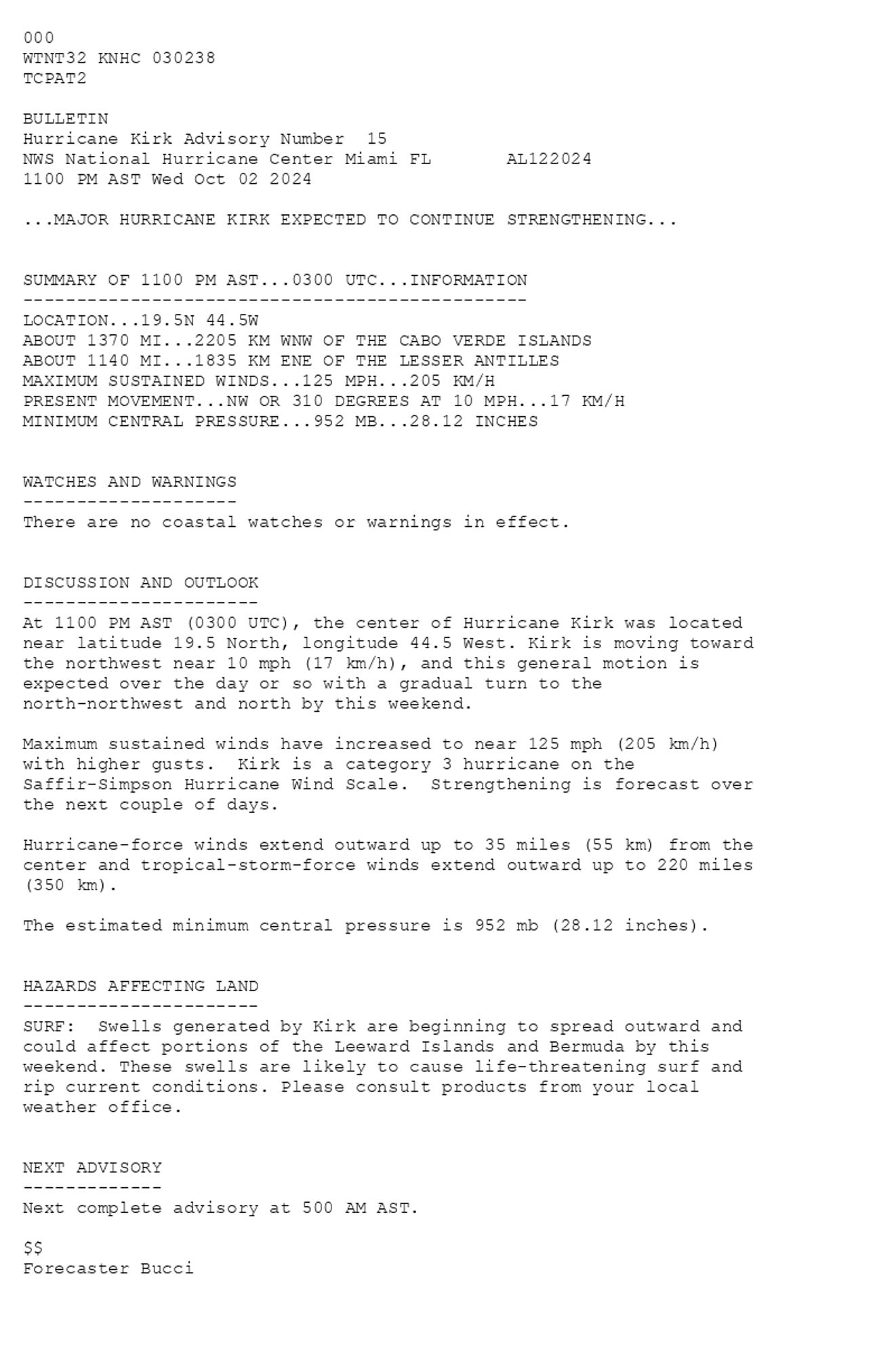
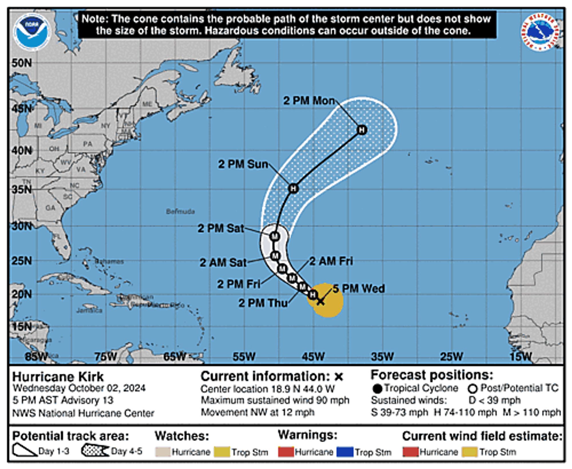
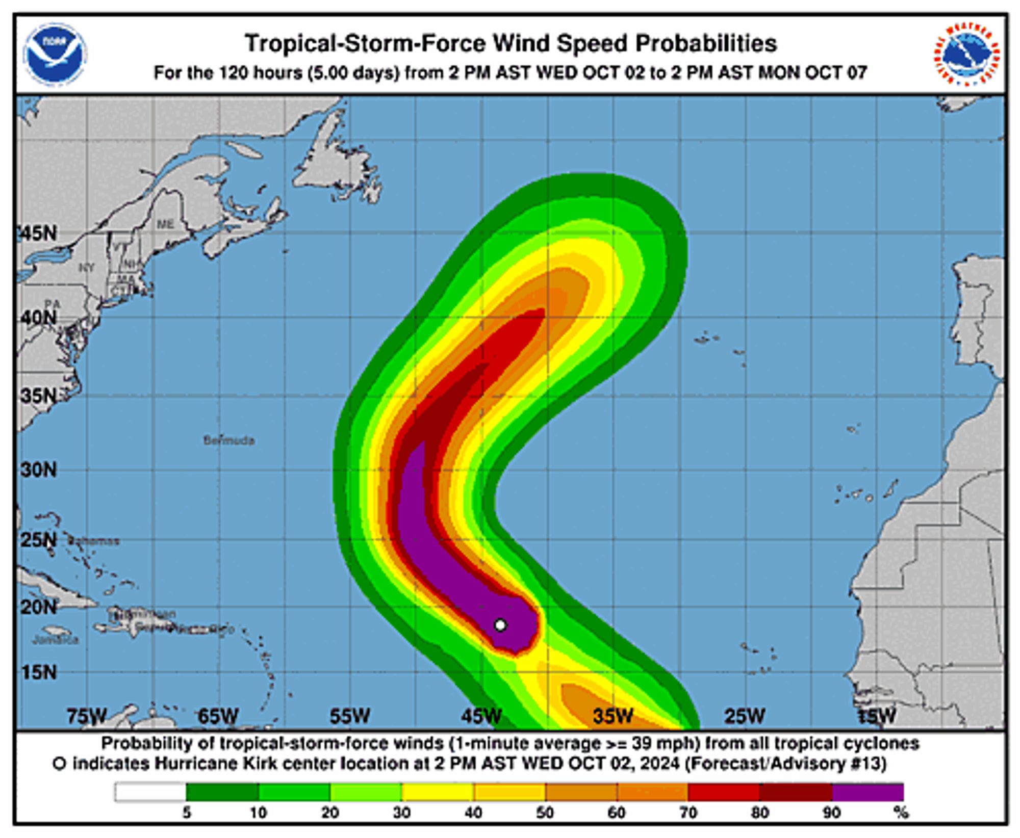
Atlantic Hurricane Kirk Advisory Number 15 issued at Thu, 03 Oct 2024 02:38:08 +0000 ...MAJOR HURRICANE KIRK EXPECTED TO CONTINUE STRENGTHENING... Additional Details Here.


 <br />
 000<br />
 WTNT32 KNHC 030238<br />
 TCPAT2<br />
  <br />
 BULLETIN<br />
 Hurricane Kirk Advisory Number  15<br />
 NWS National Hurricane Center Miami FL       AL122024<br />
 1100 PM AST Wed Oct 02 2024<br />
  <br />
 ...MAJOR HURRICANE KIRK EXPECTED TO CONTINUE STRENGTHENING...<br />
  <br />
  <br />
 SUMMARY OF 1100 PM AST...0300 UTC...INFORMATION<br />
 -----------------------------------------------<br />
 LOCATION...19.5N 44.5W<br />
 ABOUT 1370 MI...2205 KM WNW OF THE CABO VERDE ISLANDS<br />
 ABOUT 1140 MI...1835 KM ENE OF THE LESSER ANTILLES<br />
 MAXIMUM SUSTAINED WINDS...125 MPH...205 KM/H<br />
 PRESENT MOVEMENT...NW OR 310 DEGREES AT 10 MPH...17 KM/H<br />
 MINIMUM CENTRAL PRESSURE...952 MB...28.12 INCHES<br />
  <br />
  <br />
 WATCHES AND WARNINGS<br />
 --------------------<br />
 There are no coastal watches or warnings in effect.<br />
  <br />
  <br />
 DISCUSSION AND OUTLOOK<br />
 ----------------------<br />
 At 1100 PM AST (0300 UTC), the center of Hurricane Kirk was located <br />
 near latitude 19.5 North, longitude 44.5 West. Kirk is moving toward <br />
 the northwest near 10 mph (17 km/h), and this general motion is <br />
 expected over the day or so with a gradual turn to the <br />
 north-northwest and north by this weekend.<br />
  <br />
 Maximum sustained winds have increased to near 125 mph (205 km/h) <br />
 with higher gusts.  Kirk is a category 3 hurricane on the <br />
 Saffir-Simpson Hurricane Wind Scale.  Strengthening is forecast over <br />
 the next couple of days.<br />
  <br />
 Hurricane-force winds extend outward up to 35 miles (55 km) from the<br />
 center and tropical-storm-force winds extend outward up to 220 miles<br />
 (350 km).<br />
  <br />
 The estimated minimum central pressure is 952 mb (28.12 inches).<br />
  <br />
  <br />
 HAZARDS AFFECTING LAND<br />
 ----------------------<br />
 SURF:  Swells generated by Kirk are beginning to spread outward and<br />
 could affect portions of the Leeward Islands and Bermuda by this<br />
 weekend. These swells are likely to cause life-threatening surf and<br />
 rip current conditions. Please consult products from your local<br />
 weather office.<br />
  <br />
  <br />
 NEXT ADVISORY<br />
 -------------<br />
 Next complete advisory at 500 AM AST.<br />
  <br />
 $$<br />
 Forecaster Bucci<br />
  <br />
Hurricane Kirk 5-Day Uncertainty Track Image
Hurricane Kirk 34-Knot Wind Speed Probabilities
0
NHnhc-epac.nws-bot.us

NHC Eastern North Pacific Outlook update for Thu, 03 Oct 2024 02:39:14 GMT Additional Details Here.


ZCZC MIATWOEP ALL<br>TTAA00 KNHC DDHHMM<br><br>Tropical Weather Outlook<br>NWS National Hurricane Center Miami FL<br>500 PM PDT Wed Oct 2 2024<br><br>For the eastern North Pacific...east of 140 degrees west longitude:<br><br>The National Hurricane Center is issuing advisories on Tropical <br>Depression Eleven-E, located near the coast of southeastern <br>Mexico.<br><br>1. Western Portion of the East Pacific:<br>An area of showers and thunderstorms is associated with a low <br>pressure system located well to the west-southwest of the southern <br>tip of the Baja California peninsula.  This system is forecast to  <br>move slowly northward for the next couple of days, and some gradual <br>development is possible during that time.  By the weekend, <br>atmospheric conditions should become increasingly hostile, <br>preventing any further development.<br>* Formation chance through 48 hours...low...10 percent. <br>* Formation chance through 7 days...low...10 percent.<br><br>
<br>Forecaster Bucci<br><br>
Eastern North Pacific 2-Day Graphical Outlook Image
Eastern North Pacific 7-Day Graphical Outlook Image
0
NHnhc-atlc.nws-bot.us

NHC Atlantic Outlook update for Thu, 03 Oct 2024 02:38:22 GMT Additional Details Here.


ZCZC MIATWOAT ALL<br>TTAA00 KNHC DDHHMM<br><br>Tropical Weather Outlook<br>NWS National Hurricane Center Miami FL<br>800 PM EDT Wed Oct 2 2024<br><br>For the North Atlantic...Caribbean Sea and the Gulf of Mexico:<br><br>Active Systems:<br>The National Hurricane Center is issuing advisories on Hurricane <br>Kirk, located over the central tropical Atlantic Ocean, and on <br>Tropical Depression Thirteen, located over the eastern tropical <br>Atlantic Ocean.<br><br>1. Northwestern Caribbean Sea and Gulf of Mexico:<br>Disorganized showers and thunderstorms over portions of the <br>northwestern Caribbean Sea and the Gulf of Mexico are associated <br>with a trough of low pressure. Environmental conditions could <br>support some gradual development of this system over the Gulf of <br>Mexico this weekend while the system drifts eastward.  Regardless of <br>development, locally heavy rains could occur over portions of Mexico <br>during the next few days and over portions of the Florida Peninsula <br>by the weekend.<br>* Formation chance through 48 hours...low...near 0 percent. <br>* Formation chance through 7 days...low...30 percent.<br><br>
<br>Public Advisories on Tropical Depression Thirteen are issued under <br>WMO header WTNT33 KNHC and under AWIPS header MIATCPAT3.<br>Forecast/Advisories on Tropical Depression Thirteen are issued under <br>WMO header WTNT23 KNHC and under AWIPS header MIATCMAT3.<br><br>Forecaster Cangialosi<br><br>
Atlantic 2-Day Graphical Outlook Image
Atlantic 7-Day Graphical Outlook Image
0
MBmaliburek.bsky.social

UK was great and Sweden was phenomenal. Mexico and Brazil were also and there is a Arab version coming on Oct 10. The only franchise I can’t get into is the Japanese one.

0
DFdfhak.bsky.social

Well they put the 18-21 year old women as border spotters, unarmed alone and outnumbered. Then they ignore their intel of a massive attack being planned in plain sight. Only a couple survived Oct 7 and many refused to serve there after. The general at fault resigned tho so all forgiven

1