BLUE
GFgatofedido.bsky.social

Ta pra voltar ja kkkk o elon tirou o nome do spc e serasa

0
STspc-storms.nws-bot.us

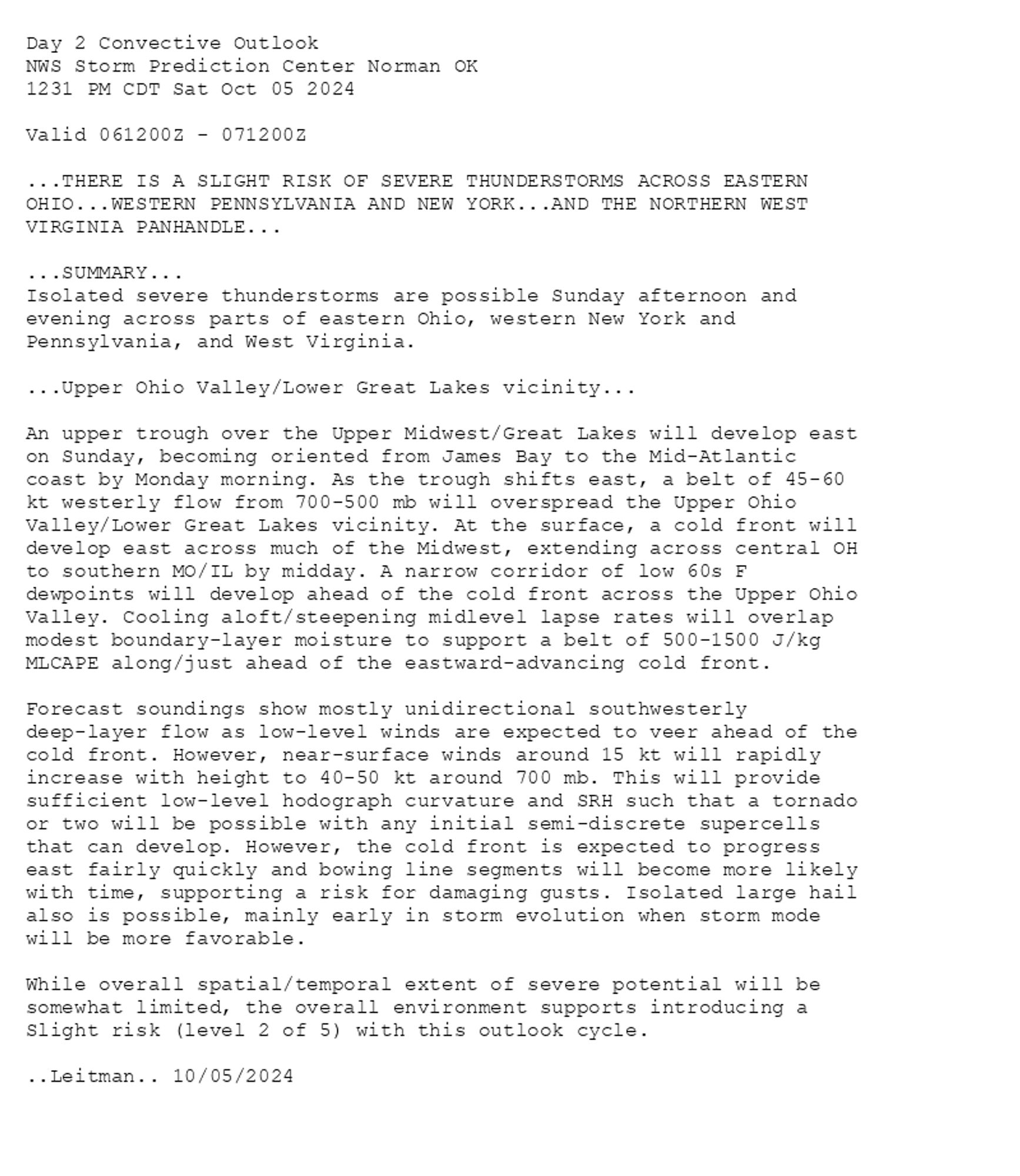
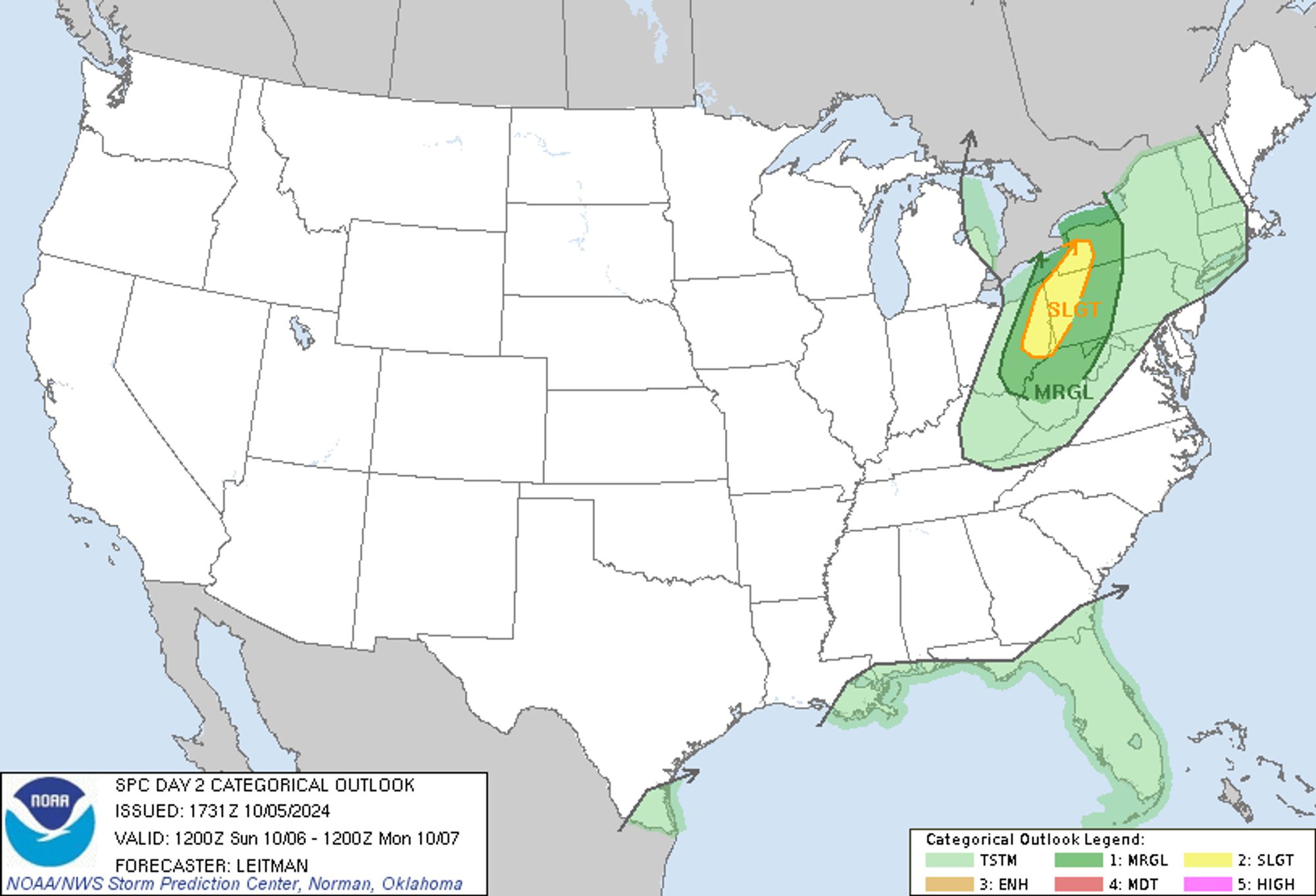
SPC Oct 5, 2024 1730 UTC Day 2 Convective Outlook ⛈️THERE IS A SLIGHT RISK OF SEVERE THUNDERSTORMS ACROSS EASTERN OHIO🌪️ Additional Details Here.


Day 2 Convective Outlook  
NWS Storm Prediction Center Norman OK
1231 PM CDT Sat Oct 05 2024

Valid 061200Z - 071200Z

...THERE IS A SLIGHT RISK OF SEVERE THUNDERSTORMS ACROSS EASTERN
OHIO...WESTERN PENNSYLVANIA AND NEW YORK...AND THE NORTHERN WEST
VIRGINIA PANHANDLE...

...SUMMARY...
Isolated severe thunderstorms are possible Sunday afternoon and
evening across parts of eastern Ohio, western New York and
Pennsylvania, and West Virginia.

...Upper Ohio Valley/Lower Great Lakes vicinity...

An upper trough over the Upper Midwest/Great Lakes will develop east
on Sunday, becoming oriented from James Bay to the Mid-Atlantic
coast by Monday morning. As the trough shifts east, a belt of 45-60
kt westerly flow from 700-500 mb will overspread the Upper Ohio
Valley/Lower Great Lakes vicinity. At the surface, a cold front will
develop east across much of the Midwest, extending across central OH
to southern MO/IL by midday. A narrow corridor of low 60s F
dewpoints will develop ahead of the cold front across the Upper Ohio
Valley. Cooling aloft/steepening midlevel lapse rates will overlap
modest boundary-layer moisture to support a belt of 500-1500 J/kg
MLCAPE along/just ahead of the eastward-advancing cold front. 

Forecast soundings show mostly unidirectional southwesterly
deep-layer flow as low-level winds are expected to veer ahead of the
cold front. However, near-surface winds around 15 kt will rapidly
increase with height to 40-50 kt around 700 mb. This will provide
sufficient low-level hodograph curvature and SRH such that a tornado
or two will be possible with any initial semi-discrete supercells
that can develop. However, the cold front is expected to progress
east fairly quickly and bowing line segments will become more likely
with time, supporting a risk for damaging gusts. Isolated large hail
also is possible, mainly early in storm evolution when storm mode
will be more favorable. 

While overall spatial/temporal extent of severe potential will be
somewhat limited, the overall environment supports introducing a
Slight risk (level 2 of 5) with this outlook cycle.

..Leitman.. 10/05/2024
Day 2 Outlook Image
0
Sdontfxrget.bsky.social

O NOME SUJO NO SPC E SERASA KKKKKKKKKKKKKKKKKKKKKKKKKKKKKKKKKKKKKKKKKKKKKKKKKKKKKKKKKKKKKKKKKKKKKKKKKKK

0
BDgahamada.bsky.social

o e*on m*sk com o nome no SPC e SERASA vsf KKKKKKKKKKKKKKKKK
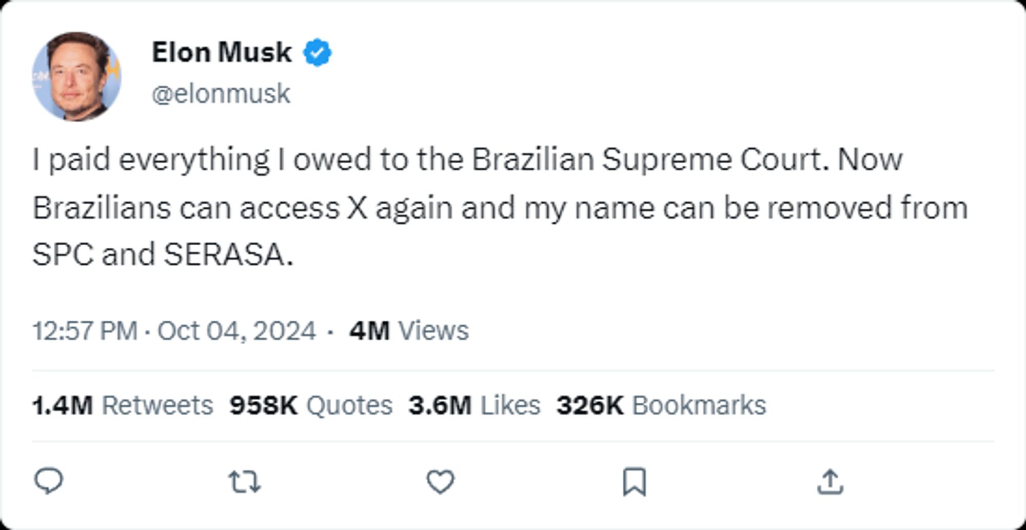
0
JJjaemjenadv.bsky.social

o elon musk pedindo pra tirar o nome dele do spc e serasa ajskskk aff que ódio

0
BEbambi45287588.bsky.social

Eu vivi pra ver um bilionário com o nome no serasa e no spc antes de mim q tenho 6 reais na conta

0
SFspc-fire.nws-bot.us

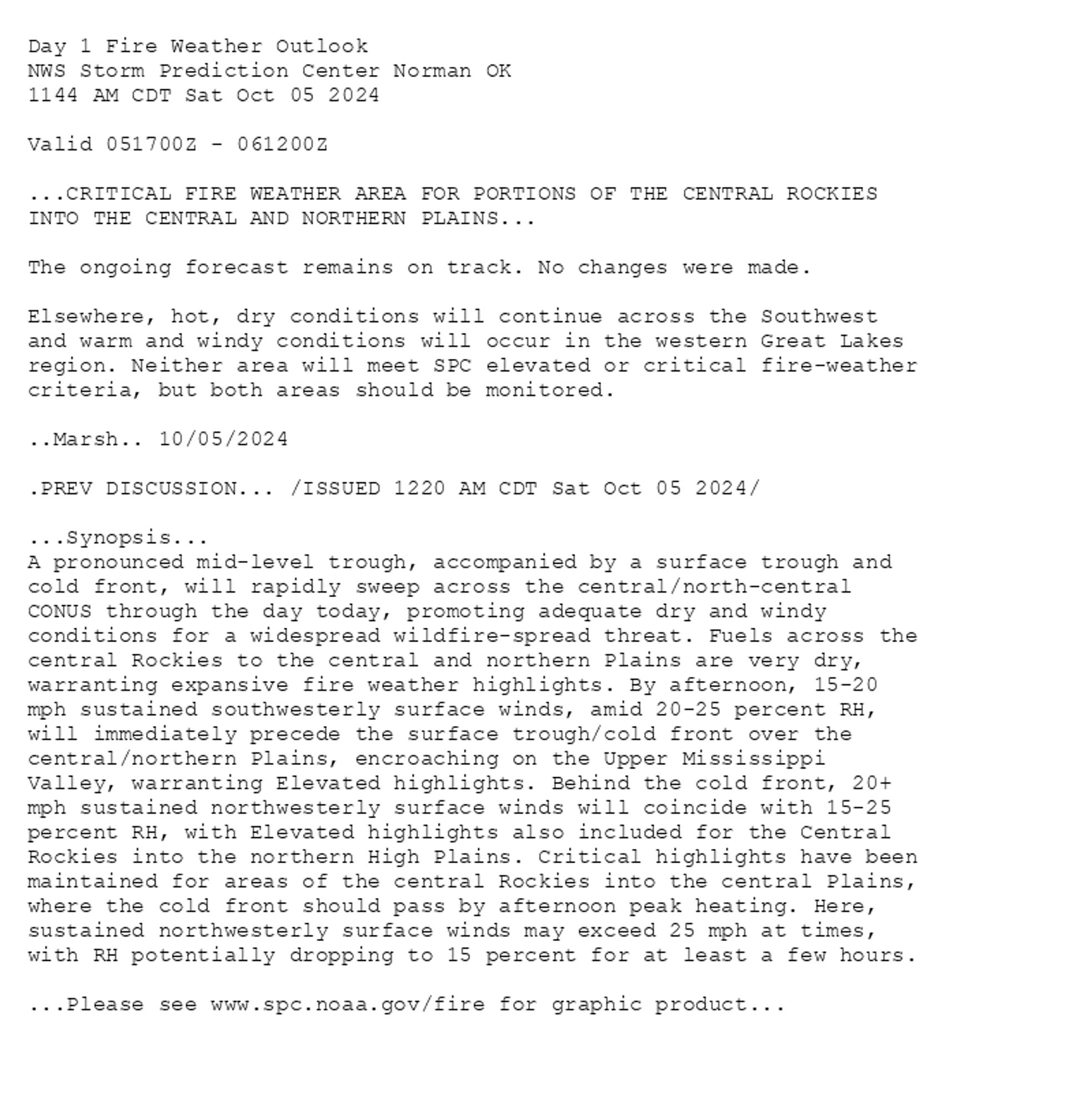
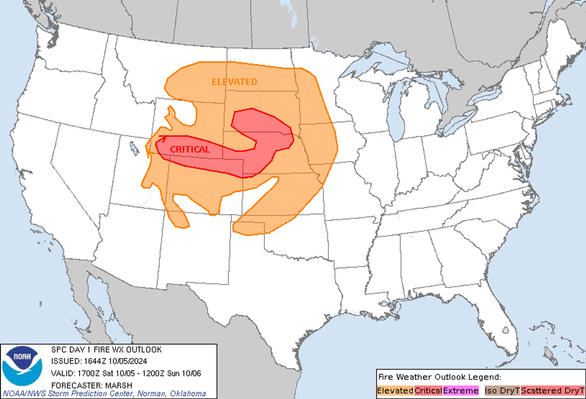
SPC Day 1 Fire Weather Outlook posted at Sat, 05 Oct 2024 16:46:32 +0000 🔥CRITICAL FIRE WEATHER AREA FOR PORTIONS OF THE CENTRAL ROCKIES INTO THE CENTRAL AND NORTHERN PLAINS🔥 Additional Details Here.


Day 1 Fire Weather Outlook  
NWS Storm Prediction Center Norman OK
1144 AM CDT Sat Oct 05 2024

Valid 051700Z - 061200Z

...CRITICAL FIRE WEATHER AREA FOR PORTIONS OF THE CENTRAL ROCKIES
INTO THE CENTRAL AND NORTHERN PLAINS...

The ongoing forecast remains on track. No changes were made. 

Elsewhere, hot, dry conditions will continue across the Southwest
and warm and windy conditions will occur in the western Great Lakes
region. Neither area will meet SPC elevated or critical fire-weather
criteria, but both areas should be monitored.

..Marsh.. 10/05/2024

.PREV DISCUSSION... /ISSUED 1220 AM CDT Sat Oct 05 2024/

...Synopsis...
A pronounced mid-level trough, accompanied by a surface trough and
cold front, will rapidly sweep across the central/north-central
CONUS through the day today, promoting adequate dry and windy
conditions for a widespread wildfire-spread threat. Fuels across the
central Rockies to the central and northern Plains are very dry,
warranting expansive fire weather highlights. By afternoon, 15-20
mph sustained southwesterly surface winds, amid 20-25 percent RH,
will immediately precede the surface trough/cold front over the
central/northern Plains, encroaching on the Upper Mississippi
Valley, warranting Elevated highlights. Behind the cold front, 20+
mph sustained northwesterly surface winds will coincide with 15-25
percent RH, with Elevated highlights also included for the Central
Rockies into the northern High Plains. Critical highlights have been
maintained for areas of the central Rockies into the central Plains,
where the cold front should pass by afternoon peak heating. Here,
sustained northwesterly surface winds may exceed 25 mph at times,
with RH potentially dropping to 15 percent for at least a few hours.

...Please see www.spc.noaa.gov/fire for graphic product...
Day 1 Fire Weather Outlook Image
0
ginholopes.bsky.social

Mentira eu tenho iPhone moro de aluguel e estou devendo pra SPC e serasa

0
BRwiconiconii.bsky.social

Primeiro é o STF pedindo pra registrar o twitter na JUNTA COMERCIAL aí agr é o Elon Musk com nome sujo no Serasa e SPC namoral tem hr q eu amo a burocracia desse país KKKKKKKKKKKKKKKKKKKKKKKKKKKKKKKKKJ

0