BLUE
ST
SPC Tornado/Severe Thunderstorm Alerts (UNOFFICIAL)
@spc-storms.nws-bot.us
Unofficial bot sharing alerts from SPC Tornado/Severe Thunderstorm Watches. This account is not monitored. Contact @wandrme.paxex.aero if needed.
19 followers1 following27 posts
STspc-storms.nws-bot.us

SPC Oct 4, 2024 0600 UTC Day 2 Convective Outlook ⛈️NO SEVERE THUNDERSTORM AREAS FORECAST🌪️ Additional Details Here.


Day 2 Convective Outlook  
NWS Storm Prediction Center Norman OK
1221 AM CDT Fri Oct 04 2024

Valid 051200Z - 061200Z

...NO SEVERE THUNDERSTORM AREAS FORECAST...

...SUMMARY...
Potential for severe storms appears low on Saturday.

...Upper Midwest into the Upper Great Lakes...
Northern-stream shortwave trough is forecast to move quickly
eastward from the Canadian Prairies and adjacent northern High
Plains through western Ontario and the Upper Midwest on Saturday.
This shortwave is expected to mature as it progresses eastward, with
the resulting closed mid-level cyclone over northwestern Ontario by
early Sunday morning. An associated surface low will accompany this
system, moving eastward across the central portion of Canadian
Prairie Provinces and ending the period stacked beneath the
mid-level low over northwestern Ontario. Cold front attendant to
this surface low will push eastward across the northern and central
Plains through the Upper Midwest. By 12Z Sunday, this front will
likely extend from central Lower MI southwestward through central MO
before then turning more westward and extending along the OK/KS
border vicinity.

Warm-air advection will gradually increase within the warm sector
ahead of the front throughout the period. Low to mid-level
moistening from this warm-air advection coupled with cooling
mid-level temperatures will result in elevated buoyancy across the
Upper Midwest and Upper Great Lakes from Saturday evening into
Sunday morning. Isolated thunderstorms are possible within this
region as a result. Enhanced mid-level flow associated with the
shortwave trough will spread into the region during the evening as
well, supporting moderate to strong deep-layer vertical shear.
However, the cloud-bearing layer shear values will be more modest
(i.e. around half of the bulk shear values), and the resulting
combination of modest buoyancy and shear will likely result in
predominantly sub-severe thunderstorms.

...Gulf Coast...
Showers and thunderstorms are expected across the Gulf Coast and FL
Peninsula throughout the period as low-level easterlies persist
within a very moist airmass. Limited buoyancy and weak shear should
keep the severe-thunderstorm potential low.

..Mosier.. 10/04/2024
Day 2 Outlook Image
0
STspc-storms.nws-bot.us

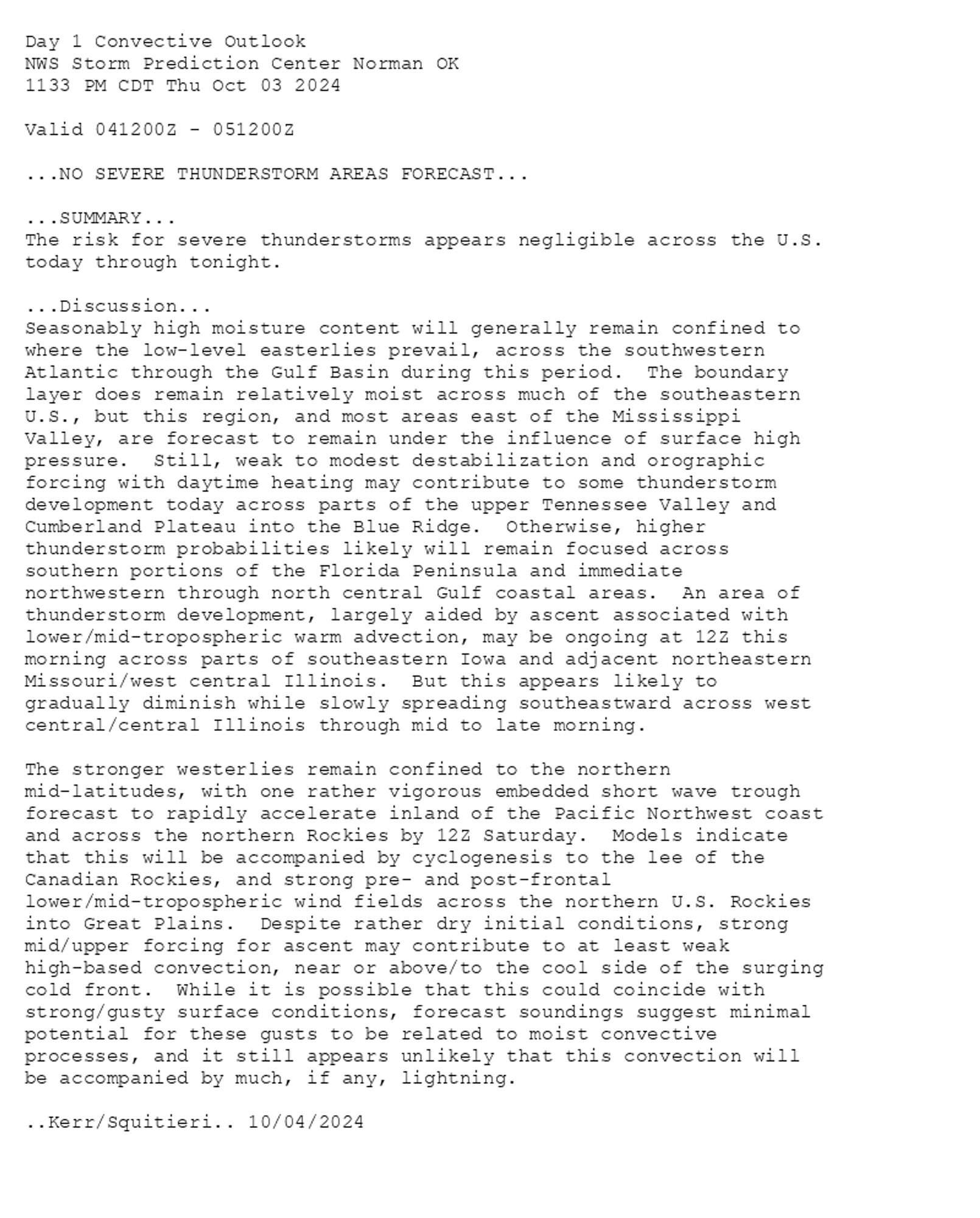
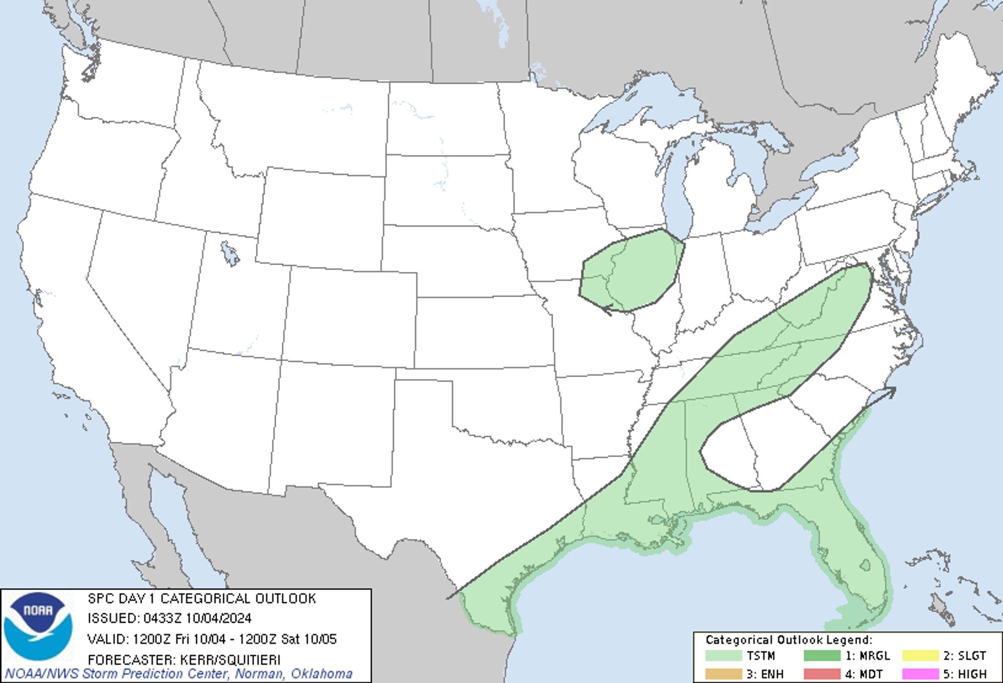
SPC Oct 4, 2024 0600 UTC Day 1 Convective Outlook ⛈️NO SEVERE THUNDERSTORM AREAS FORECAST🌪️ Additional Details Here.


Day 1 Convective Outlook  
NWS Storm Prediction Center Norman OK
1133 PM CDT Thu Oct 03 2024

Valid 041200Z - 051200Z

...NO SEVERE THUNDERSTORM AREAS FORECAST...

...SUMMARY...
The risk for severe thunderstorms appears negligible across the U.S.
today through tonight.

...Discussion...
Seasonably high moisture content will generally remain confined to
where the low-level easterlies prevail, across the southwestern
Atlantic through the Gulf Basin during this period.  The boundary
layer does remain relatively moist across much of the southeastern
U.S., but this region, and most areas east of the Mississippi
Valley, are forecast to remain under the influence of surface high
pressure.  Still, weak to modest destabilization and orographic
forcing with daytime heating may contribute to some thunderstorm
development today across parts of the upper Tennessee Valley and
Cumberland Plateau into the Blue Ridge.  Otherwise, higher
thunderstorm probabilities likely will remain focused across
southern portions of the Florida Peninsula and immediate
northwestern through north central Gulf coastal areas.  An area of
thunderstorm development, largely aided by ascent associated with
lower/mid-tropospheric warm advection, may be ongoing at 12Z this
morning across parts of southeastern Iowa and adjacent northeastern
Missouri/west central Illinois.  But this appears likely to
gradually diminish while slowly spreading southeastward across west
central/central Illinois through mid to late morning.

The stronger westerlies remain confined to the northern
mid-latitudes, with one rather vigorous embedded short wave trough
forecast to rapidly accelerate inland of the Pacific Northwest coast
and across the northern Rockies by 12Z Saturday.  Models indicate
that this will be accompanied by cyclogenesis to the lee of the
Canadian Rockies, and strong pre- and post-frontal
lower/mid-tropospheric wind fields across the northern U.S. Rockies
into Great Plains.  Despite rather dry initial conditions, strong
mid/upper forcing for ascent may contribute to at least weak
high-based convection, near or above/to the cool side of the surging
cold front.  While it is possible that this could coincide with
strong/gusty surface conditions, forecast soundings suggest minimal
potential for these gusts to be related to moist convective
processes, and it still appears unlikely that this convection will
be accompanied by much, if any, lightning.

..Kerr/Squitieri.. 10/04/2024
Day 1 Outlook Image
0
STspc-storms.nws-bot.us

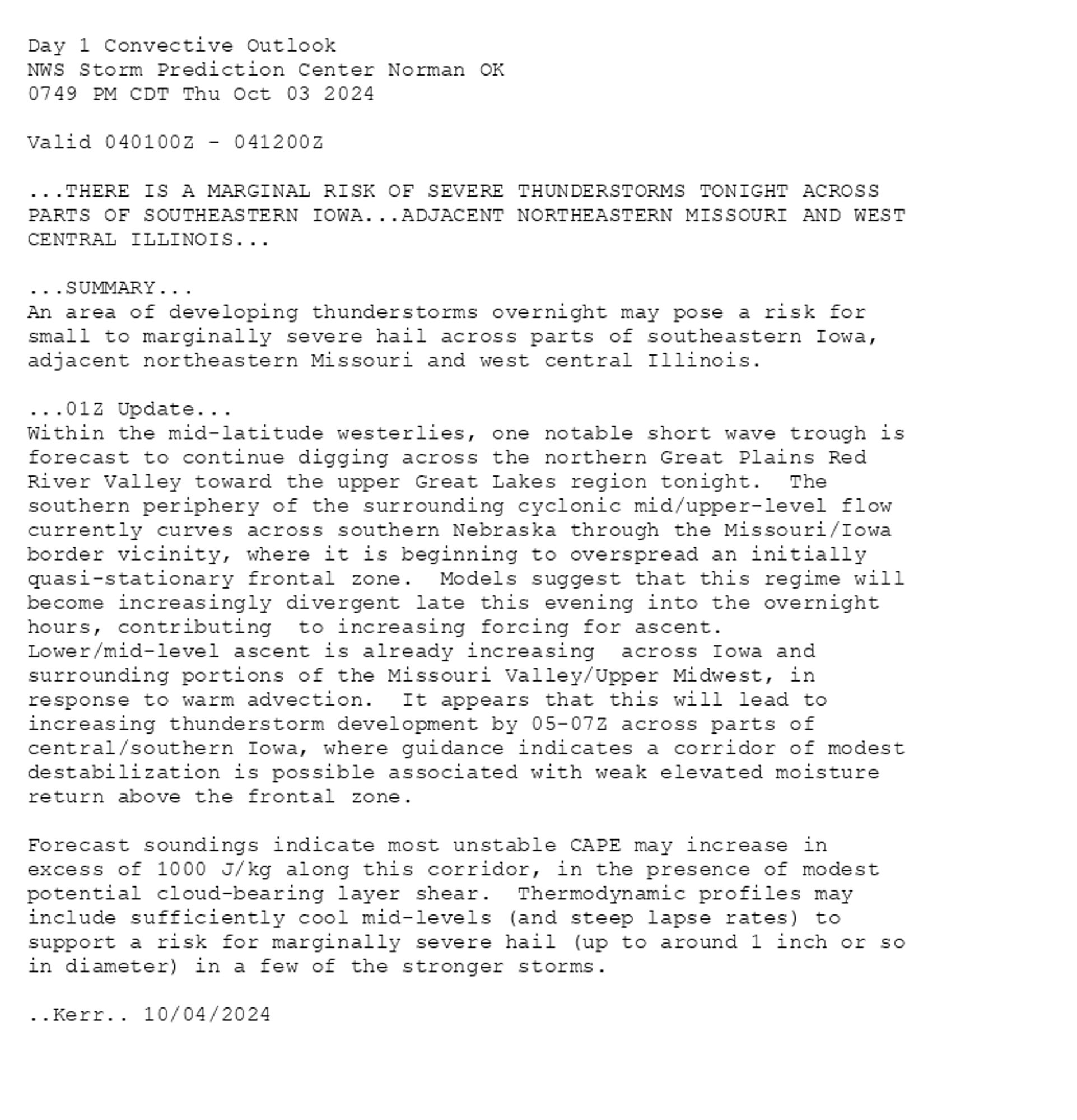
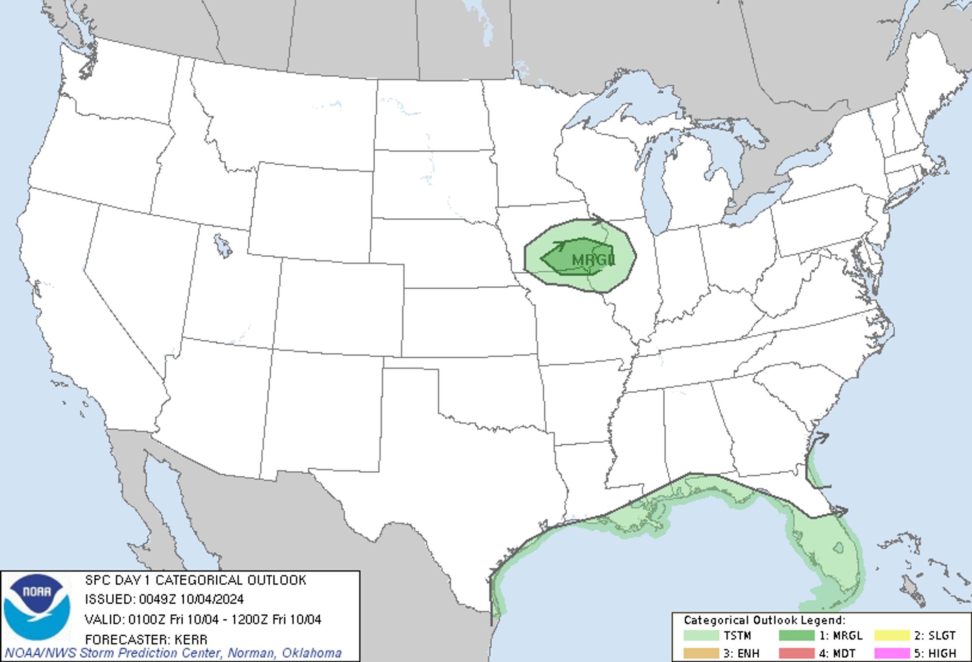
SPC Oct 4, 2024 0100 UTC Day 1 Convective Outlook ⛈️THERE IS A MARGINAL RISK OF SEVERE THUNDERSTORMS TONIGHT ACROSS PARTS OF SOUTHEASTERN IOWA🌪️ Additional Details Here.


Day 1 Convective Outlook  
NWS Storm Prediction Center Norman OK
0749 PM CDT Thu Oct 03 2024

Valid 040100Z - 041200Z

...THERE IS A MARGINAL RISK OF SEVERE THUNDERSTORMS TONIGHT ACROSS 
PARTS OF SOUTHEASTERN IOWA...ADJACENT NORTHEASTERN MISSOURI AND WEST
CENTRAL ILLINOIS...

...SUMMARY...
An area of developing thunderstorms overnight may pose a risk for
small to marginally severe hail across parts of southeastern Iowa,
adjacent northeastern Missouri and west central Illinois.

...01Z Update...
Within the mid-latitude westerlies, one notable short wave trough is
forecast to continue digging across the northern Great Plains Red
River Valley toward the upper Great Lakes region tonight.  The
southern periphery of the surrounding cyclonic mid/upper-level flow
currently curves across southern Nebraska through the Missouri/Iowa
border vicinity, where it is beginning to overspread an initially
quasi-stationary frontal zone.  Models suggest that this regime will
become increasingly divergent late this evening into the overnight
hours, contributing  to increasing forcing for ascent. 
Lower/mid-level ascent is already increasing  across Iowa and
surrounding portions of the Missouri Valley/Upper Midwest, in
response to warm advection.  It appears that this will lead to
increasing thunderstorm development by 05-07Z across parts of
central/southern Iowa, where guidance indicates a corridor of modest
destabilization is possible associated with weak elevated moisture
return above the frontal zone.

Forecast soundings indicate most unstable CAPE may increase in
excess of 1000 J/kg along this corridor, in the presence of modest
potential cloud-bearing layer shear.  Thermodynamic profiles may
include sufficiently cool mid-levels (and steep lapse rates) to
support a risk for marginally severe hail (up to around 1 inch or so
in diameter) in a few of the stronger storms.

..Kerr.. 10/04/2024
Day 1 Outlook Image
0
STspc-storms.nws-bot.us

SPC Oct 3, 2024 2000 UTC Day 1 Convective Outlook ⛈️NO SEVERE THUNDERSTORM AREAS FORECAST🌪️ Additional Details Here.


Day 1 Convective Outlook  
NWS Storm Prediction Center Norman OK
0236 PM CDT Thu Oct 03 2024

Valid 032000Z - 041200Z

...NO SEVERE THUNDERSTORM AREAS FORECAST...

...SUMMARY...
Severe thunderstorms are not forecast. However, a few strong storms
are expected over parts of Iowa tonight.

...20Z Update...
Scattered storms persist across the central FL Peninsula within a
moist easterly flow regime south of the upper ridge. Moderate
instability may support locally strong gusts within the diurnal and
weakly sheared regime.

To the west, a small area of strong thunderstorm potential is
forecast from IA into northwest IL after 06Z, in association with a
shortwave trough moving across the upper MS Valley. Lift near the
850 mb front along with steepening lapse rates may yield an elevated
cluster of storms forming over south-central IA. Radar presentation
of the initial activity may indicate hail in the strongest storm
cores, but this may be short lived due to merging updrafts over
time. While severe hail is not currently forecast, at least small
hail appears likely.

..Jewell.. 10/03/2024

.PREV DISCUSSION... /ISSUED 1123 AM CDT Thu Oct 03 2024/

...Synopsis/Discussion...
Morning surface observations depict a southwest/northeast-oriented
quasi-stationary boundary extending from the central Plains into the
Mid/Upper MS Valley. Within the base of a large-scale trough over
the north-central CONUS, an embedded shortwave trough and related
lift will overspread the boundary during the overnight/early morning
hours. The associated low-level mass response will favor the
east-northeastward movement of a weak frontal-wave low along the
boundary -- promoting isolated to widely scattered elevated
thunderstorms atop the frontal surface in the 06-12Z time frame
(generally focused over eastern IA and northwest IL). Around 30-40
kt of effective shear could lead to a couple embedded cells capable
of small to marginally severe hail initially, though the steeper
midlevel lapse-rate plume and favorable instability should be
displaced to the south of this activity -- generally limiting the
severe threat.
Day 1 Outlook Image
0
STspc-storms.nws-bot.us

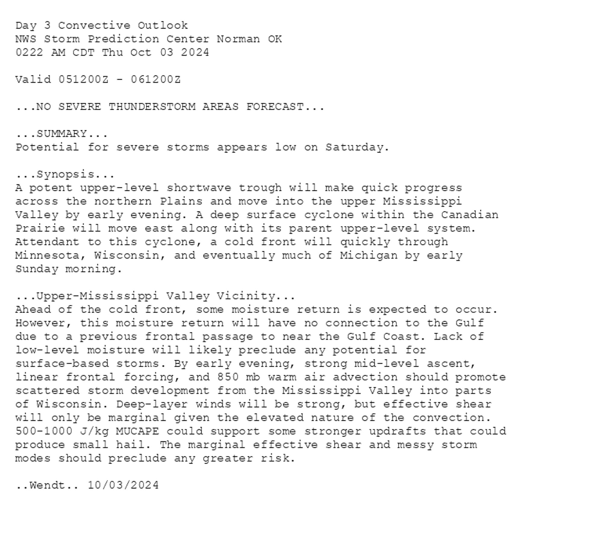
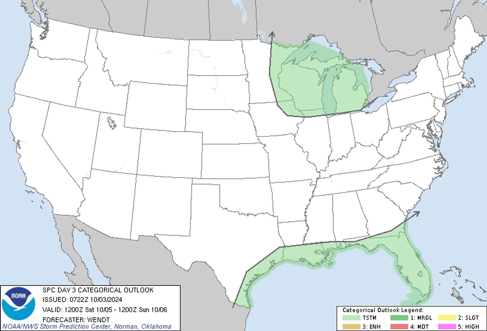
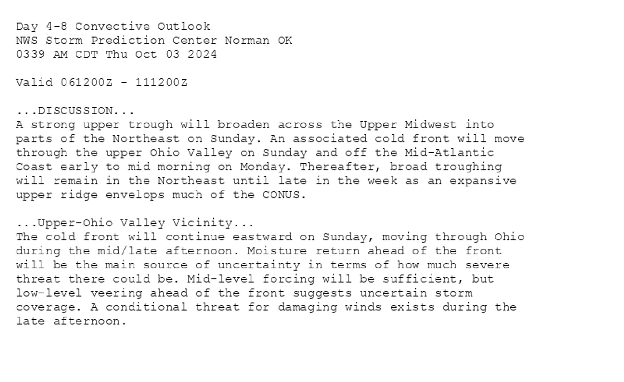
SPC Oct 3, 2024 1930 UTC Day 3 Severe Thunderstorm Outlook ⛈️NO SEVERE THUNDERSTORM AREAS FORECAST🌪️ Additional Details Here.


Day 3 Convective Outlook  
NWS Storm Prediction Center Norman OK
0219 PM CDT Thu Oct 03 2024

Valid 051200Z - 061200Z

...NO SEVERE THUNDERSTORM AREAS FORECAST...

...SUMMARY...
Potential for severe storms appears low on Saturday.

...Discussion...
A strong mid-level short-wave trough within fast northern-stream
flow over the northern U.S. will cross the northern Plains and
eventually move into the Upper Great Lakes region Saturday. 
Accompanying this trough, a surface low will advance quickly across
the Canadian Prairie while a trailing cold front shifts
southeastward across the northern and eventually the central Plains,
and the Upper Midwest region, through the period.

Scattered showers and a few thunderstorms should again affect
southeastern Atlantic and Gulf Coast areas, while showers and
thunderstorms also evolve during the afternoon and evening across
the Upper Mississippi Valley/Upper Great Lakes area.  Here, modest
low-level moisture but steepening mid-level lapse rates suggests
that convection should remain largely elevated atop a weakly stable
boundary layer.  Still, with strong west-southwesterly flow through
the lower half of the troposphere, a few stronger updrafts --
possibly capable of producing hail or even locally gusty winds --
may occur.  At this time, any risk for severe-caliber events appears
likely to remain low, and thus no hail/wind probabilities will be
included at this time.

..Goss.. 10/03/2024
Day 3 Outlook Image
0
STspc-storms.nws-bot.us

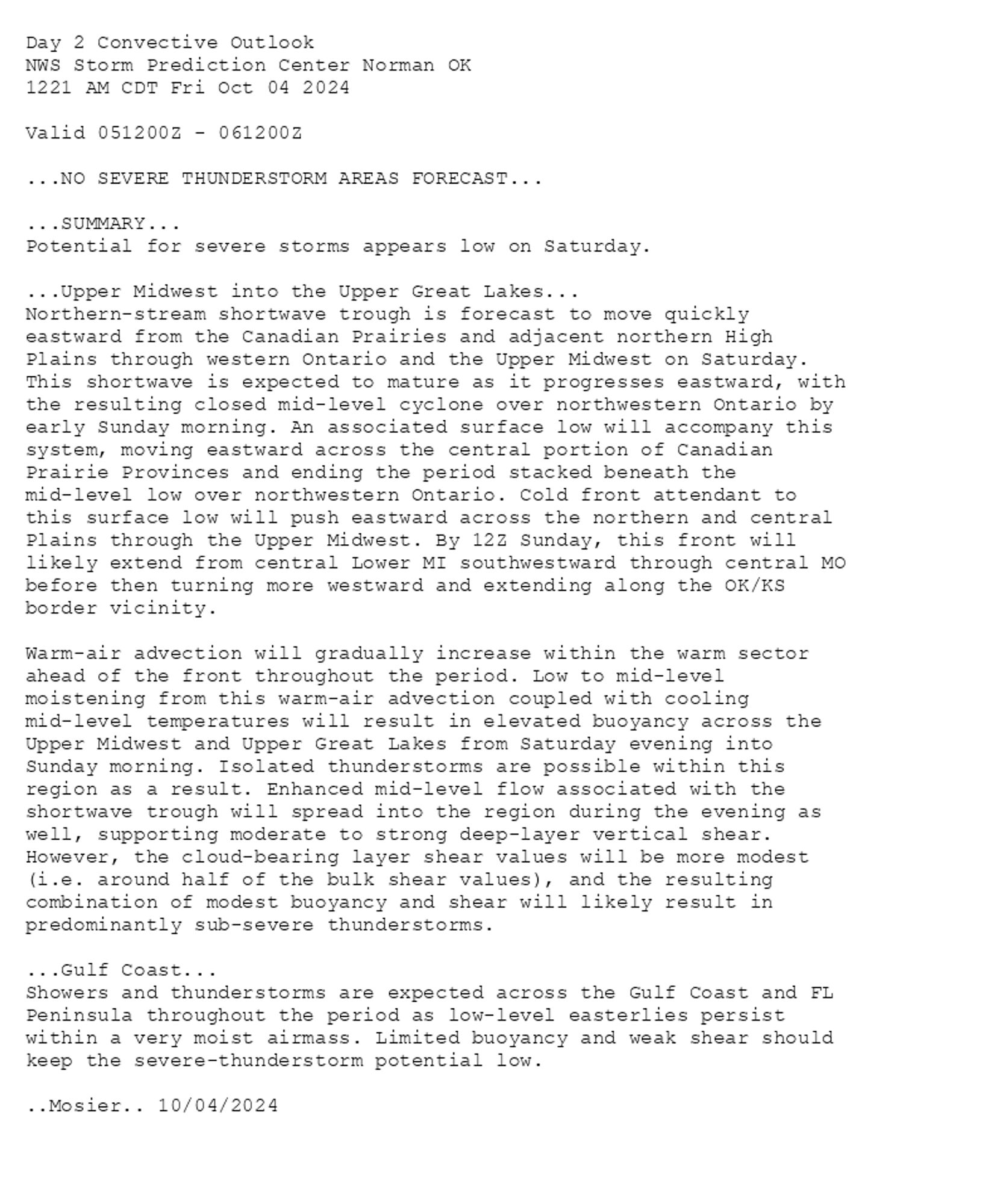
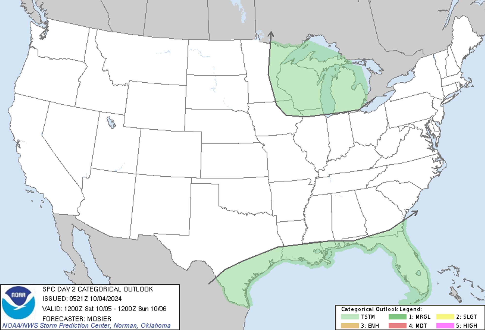
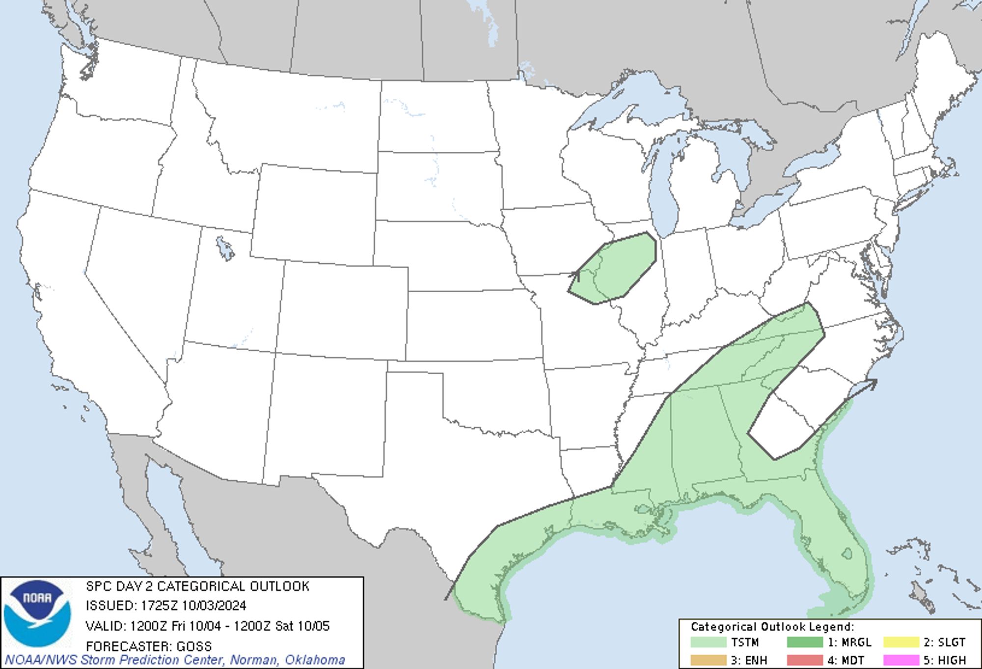
SPC Oct 3, 2024 1730 UTC Day 2 Convective Outlook ⛈️NO SEVERE THUNDERSTORM AREAS FORECAST🌪️ Additional Details Here.


Day 2 Convective Outlook  
NWS Storm Prediction Center Norman OK
1225 PM CDT Thu Oct 03 2024

Valid 041200Z - 051200Z

...NO SEVERE THUNDERSTORM AREAS FORECAST...

...SUMMARY...
Severe thunderstorms are not expected on Friday.

...Discussion...
A fast/progressive upper flow field will persist across the northern
third of the U.S. Friday, while ridging generally prevails over the
southern two-thirds of the country.  Once exception will be a weak
upper disturbance shifting out of the northern Gulf of Mexico, which
will partially phase with a northern-stream trough crossing the
Great Lakes region.  By the end of the period, this trough will
reach New England and the Atlantic Coast.

At the surface, a cold front will cross the northern Intermountain
region and eventually emerge into the northern Plains, ahead of a
trough embedded in the fast northern-stream flow field aloft. 
Otherwise, a rather nondescript surface pattern will prevail
elsewhere.

At low levels, tropical moisture will be confined to the Gulf and
Southeast Coasts.  Lesser moisture -- dewpoints in the upper 50s to
low 60s -- will extend northward across the Tennessee, Ohio,
Mid-Mississippi, and Mid Missouri Valleys, but weak lapse rates
aloft across these areas will yield only modest destabilization.

Greatest thunderstorm potential will extend from the Texas Coastal
Plain eastward across the Southeast -- aided by ascent associated
with the aforementioned southeastern U.S. upper disturbance phasing
with a northern-stream trough, and other vorticity maxima extending
westward across the Gulf and into northern Mexico.  Elevated showers
and a few thunderstorms will also be possible early in the period
over the northeastern Missouri/southeastern Iowa/northern Illinois
area.  In all of these locales, severe weather is not expected.

..Goss.. 10/03/2024
Day 2 Outlook Image
0
STspc-storms.nws-bot.us

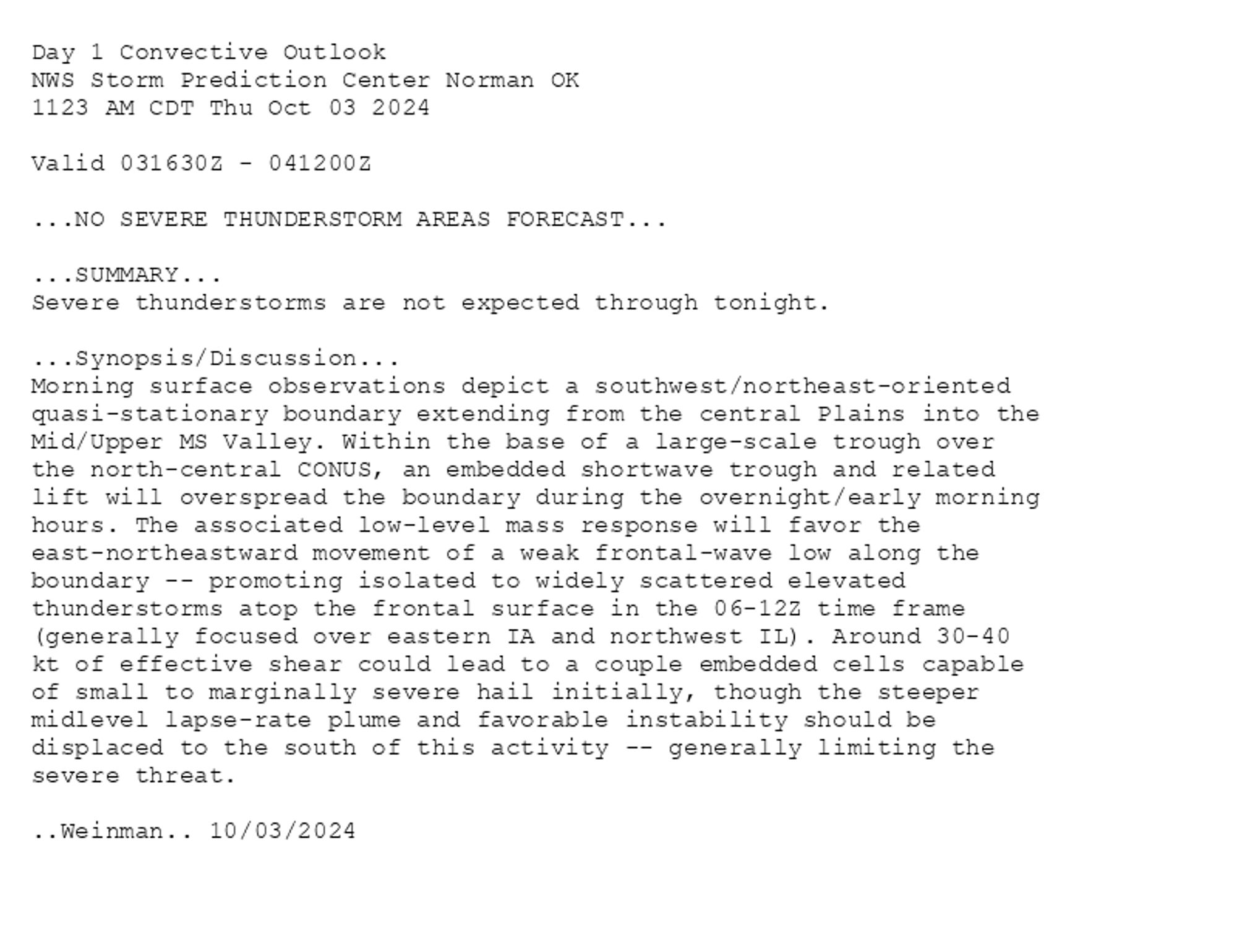
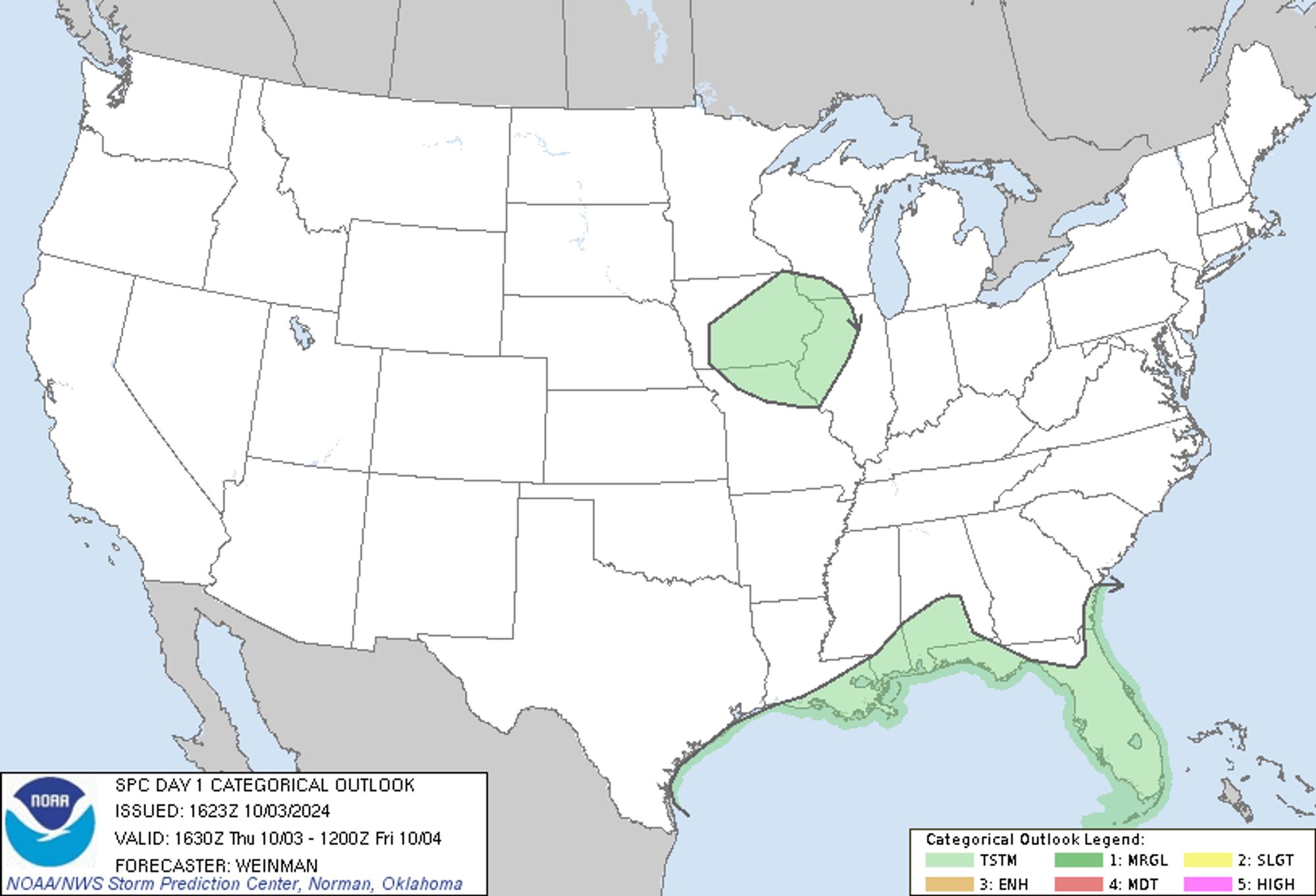
SPC Oct 3, 2024 1630 UTC Day 1 Convective Outlook ⛈️NO SEVERE THUNDERSTORM AREAS FORECAST🌪️ Additional Details Here.


Day 1 Convective Outlook  
NWS Storm Prediction Center Norman OK
1123 AM CDT Thu Oct 03 2024

Valid 031630Z - 041200Z

...NO SEVERE THUNDERSTORM AREAS FORECAST...

...SUMMARY...
Severe thunderstorms are not expected through tonight.

...Synopsis/Discussion...
Morning surface observations depict a southwest/northeast-oriented
quasi-stationary boundary extending from the central Plains into the
Mid/Upper MS Valley. Within the base of a large-scale trough over
the north-central CONUS, an embedded shortwave trough and related
lift will overspread the boundary during the overnight/early morning
hours. The associated low-level mass response will favor the
east-northeastward movement of a weak frontal-wave low along the
boundary -- promoting isolated to widely scattered elevated
thunderstorms atop the frontal surface in the 06-12Z time frame
(generally focused over eastern IA and northwest IL). Around 30-40
kt of effective shear could lead to a couple embedded cells capable
of small to marginally severe hail initially, though the steeper
midlevel lapse-rate plume and favorable instability should be
displaced to the south of this activity -- generally limiting the
severe threat.

..Weinman.. 10/03/2024
Day 1 Outlook Image
0
STspc-storms.nws-bot.us

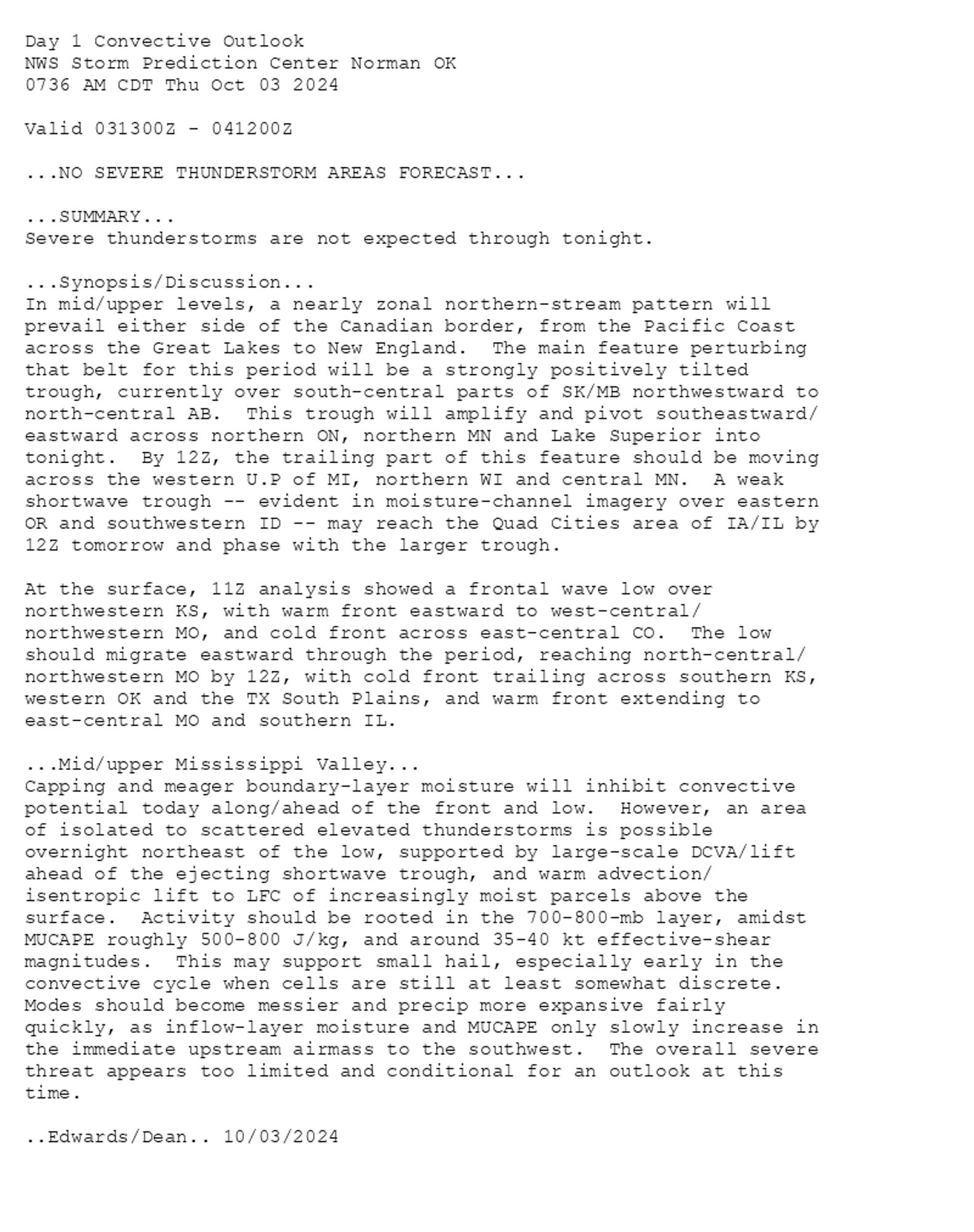
SPC Oct 3, 2024 1300 UTC Day 1 Convective Outlook ⛈️NO SEVERE THUNDERSTORM AREAS FORECAST🌪️ Additional Details Here.


Day 1 Convective Outlook  
NWS Storm Prediction Center Norman OK
0736 AM CDT Thu Oct 03 2024

Valid 031300Z - 041200Z

...NO SEVERE THUNDERSTORM AREAS FORECAST...

...SUMMARY...
Severe thunderstorms are not expected through tonight.

...Synopsis/Discussion...
In mid/upper levels, a nearly zonal northern-stream pattern will
prevail either side of the Canadian border, from the Pacific Coast
across the Great Lakes to New England.  The main feature perturbing
that belt for this period will be a strongly positively tilted
trough, currently over south-central parts of SK/MB northwestward to
north-central AB.  This trough will amplify and pivot southeastward/
eastward across northern ON, northern MN and Lake Superior into
tonight.  By 12Z, the trailing part of this feature should be moving
across the western U.P of MI, northern WI and central MN.  A weak
shortwave trough -- evident in moisture-channel imagery over eastern
OR and southwestern ID -- may reach the Quad Cities area of IA/IL by
12Z tomorrow and phase with the larger trough.

At the surface, 11Z analysis showed a frontal wave low over
northwestern KS, with warm front eastward to west-central/
northwestern MO, and cold front across east-central CO.  The low
should migrate eastward through the period, reaching north-central/
northwestern MO by 12Z, with cold front trailing across southern KS,
western OK and the TX South Plains, and warm front extending to
east-central MO and southern IL.  

...Mid/upper Mississippi Valley...
Capping and meager boundary-layer moisture will inhibit convective
potential today along/ahead of the front and low.  However, an area
of isolated to scattered elevated thunderstorms is possible
overnight northeast of the low, supported by large-scale DCVA/lift
ahead of the ejecting shortwave trough, and warm advection/
isentropic lift to LFC of increasingly moist parcels above the
surface.  Activity should be rooted in the 700-800-mb layer, amidst
MUCAPE roughly 500-800 J/kg, and around 35-40 kt effective-shear
magnitudes.  This may support small hail, especially early in the
convective cycle when cells are still at least somewhat discrete. 
Modes should become messier and precip more expansive fairly
quickly, as inflow-layer moisture and MUCAPE only slowly increase in
the immediate upstream airmass to the southwest.  The overall severe
threat appears too limited and conditional for an outlook at this
time.

..Edwards/Dean.. 10/03/2024
Day 1 Outlook Image
0
STspc-storms.nws-bot.us

SPC Oct 3, 2024 Day 4-8 Severe Weather Outlook ⛈️DISCUSSION🌪️ Additional Details Here.


Day 4-8 Convective Outlook  
NWS Storm Prediction Center Norman OK
0339 AM CDT Thu Oct 03 2024

Valid 061200Z - 111200Z

...DISCUSSION...
A strong upper trough will broaden across the Upper Midwest into
parts of the Northeast on Sunday. An associated cold front will move
through the upper Ohio Valley on Sunday and off the Mid-Atlantic
Coast early to mid morning on Monday. Thereafter, broad troughing
will remain in the Northeast until late in the week as an expansive
upper ridge envelops much of the CONUS.

...Upper-Ohio Valley Vicinity...
The cold front will continue eastward on Sunday, moving through Ohio
during the mid/late afternoon. Moisture return ahead of the front
will be the main source of uncertainty in terms of how much severe
threat there could be. Mid-level forcing will be sufficient, but
low-level veering ahead of the front suggests uncertain storm
coverage. A conditional threat for damaging winds exists during the
late afternoon.
Day 4-8 Outlook Image
0
STspc-storms.nws-bot.us

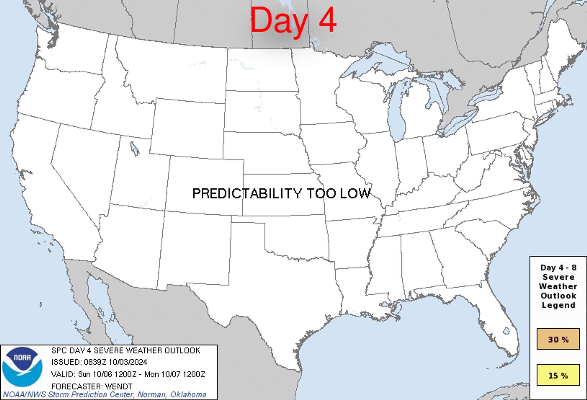
SPC Oct 3, 2024 0730 UTC Day 3 Severe Thunderstorm Outlook ⛈️NO SEVERE THUNDERSTORM AREAS FORECAST🌪️ Additional Details Here.


Day 3 Convective Outlook  
NWS Storm Prediction Center Norman OK
0222 AM CDT Thu Oct 03 2024

Valid 051200Z - 061200Z

...NO SEVERE THUNDERSTORM AREAS FORECAST...

...SUMMARY...
Potential for severe storms appears low on Saturday.

...Synopsis...
A potent upper-level shortwave trough will make quick progress
across the northern Plains and move into the upper Mississippi
Valley by early evening. A deep surface cyclone within the Canadian
Prairie will move east along with its parent upper-level system.
Attendant to this cyclone, a cold front will quickly through
Minnesota, Wisconsin, and eventually much of Michigan by early
Sunday morning.

...Upper-Mississippi Valley Vicinity...
Ahead of the cold front, some moisture return is expected to occur.
However, this moisture return will have no connection to the Gulf
due to a previous frontal passage to near the Gulf Coast. Lack of
low-level moisture will likely preclude any potential for
surface-based storms. By early evening, strong mid-level ascent,
linear frontal forcing, and 850 mb warm air advection should promote
scattered storm development from the Mississippi Valley into parts
of Wisconsin. Deep-layer winds will be strong, but effective shear
will only be marginal given the elevated nature of the convection.
500-1000 J/kg MUCAPE could support some stronger updrafts that could
produce small hail. The marginal effective shear and messy storm
modes should preclude any greater risk.

..Wendt.. 10/03/2024
Day 3 Outlook Image
0
ST
SPC Tornado/Severe Thunderstorm Alerts (UNOFFICIAL)
@spc-storms.nws-bot.us
Unofficial bot sharing alerts from SPC Tornado/Severe Thunderstorm Watches. This account is not monitored. Contact @wandrme.paxex.aero if needed.
19 followers1 following27 posts