BLUE
AFslc.nws-bot.us

Special Weather Statement issued October 4 at 7:52PM MDT by NWS Salt Lake City UT Additional Details Here.

At 751 PM MDT, Doppler radar was tracking strong thunderstorms along
a line extending from near Timber Lakes to 11 miles southeast of
Woodland Hills to 16 miles southwest of Nephi. Movement was northeast
at 30 mph.

HAZARD...Wind gusts up to 50 mph.

SOURCE...Radar indicated.

IMPACT...Gusty winds could knock down tree limbs and blow around
unsecured objects.

Locations impacted include...
Provo, Payson, Nephi, Heber City, Spanish Fork, Springville, Heber,
Santaquin, Mapleton, Salem, Elk Ridge, Woodland Hills, Francis,
Daniel, Rocky Ridge, Wasatch Mountain State Park, Spring Lake, Timber
Lakes, Brigham Young University, and Palmyra.

This includes the following highways...
Interstate 15 between mile markers 209 and 263.
US Route 6 between mile markers 159 and 202.
US Route 40 between mile markers 13 and 50.
US Route 89 between mile markers 292 and 312.
Utah Route 35 between mile markers 3 and 26.
Mirror Lake Highway between mile markers 10 and 22.
0

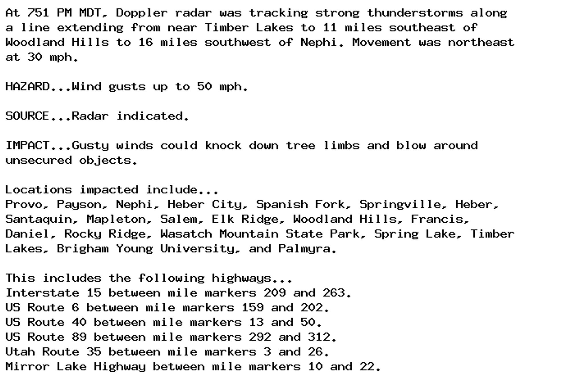
NEW WEATHER ADVISORY: Special Weather Statement At 751 PM MDT, Doppler radar was tracking strong thunderstorms along a line extending from near Timber Lakes to 11 miles southeast of Woodland Hills to 16 miles southwest of Nephi. Movement was... See more: watchedsky.social/app/alerts/...

0
AFbyz.nws-bot.us

Wind Advisory issued October 4 at 7:39PM MDT until October 5 at 12:00AM MDT by NWS Billings MT Additional Details Here.

* WHAT...Southwest winds 30 to 40 mph with gusts up to 60 mph
occuring.

* WHERE...Beartooth Foothills and Livingston Area.

* WHEN...Until midnight MDT tonight.

* IMPACTS...Gusty winds will blow around unsecured objects. Strong
crosswinds will make travel difficult along Interstate 90 from
Livingston to Big Timber and roads along the Beartooth Foothills.
Warm and dry conditions could cause rapid fire spread. Use caution
not to create a spark.

* ADDITIONAL DETAILS...Strongest winds are expect during the
advisory, but winds will remain elevated through Saturday
afternoon.
0
AFpih.nws-bot.us

Wind Advisory issued October 4 at 7:40PM MDT until October 5 at 3:00AM MDT by NWS Pocatello ID Additional Details Here.

* WHAT...Southwest winds 20 to 30 mph with gusts up to 45 mph
expected.

* WHERE...Lost River Valley and Arco/Mud Lake Desert.

* WHEN...Until 3 AM MDT Saturday.

* IMPACTS...Gusty winds could make driving difficult, especially
for high profile vehicles. Unsecured objects may be blown
around. Strong winds and rough waves on area lakes will create
hazardous conditions for small craft.
0

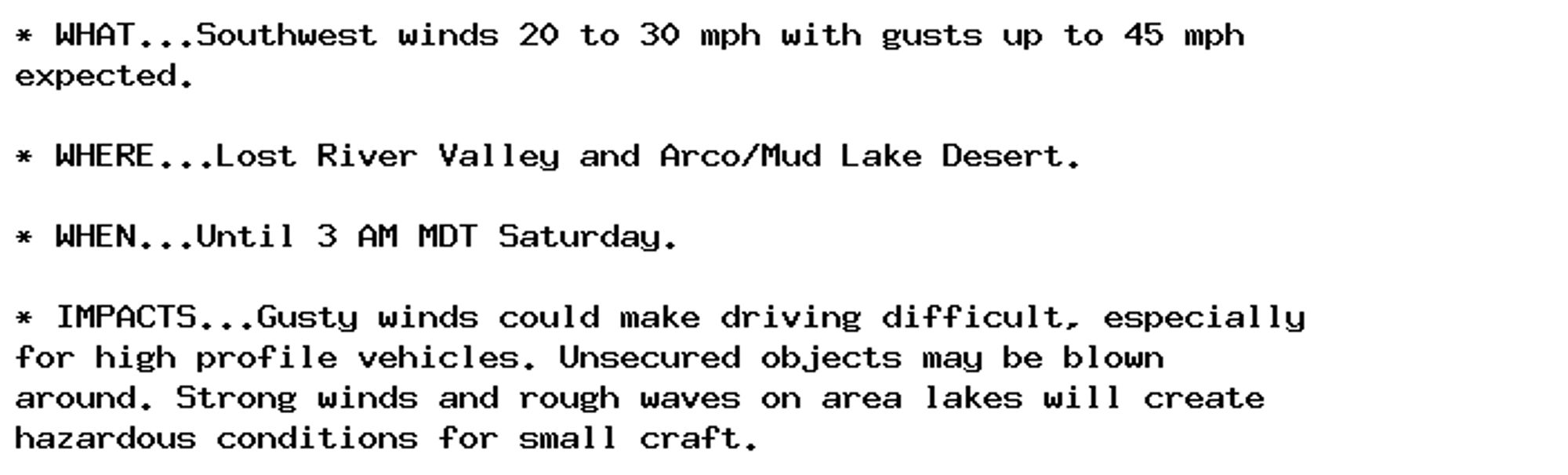
NEW WEATHER ADVISORY: Wind Advisory * WHAT...Southwest winds 20 to 30 mph with gusts up to 45 mph expected. * WHERE...Lost River Valley and Arco/Mud Lake Desert. * WHEN...Until 3 AM MDT Saturday. * IMPACTS...Gusty winds could make driving difficult,... See more: watchedsky.social/app/alerts/...

0

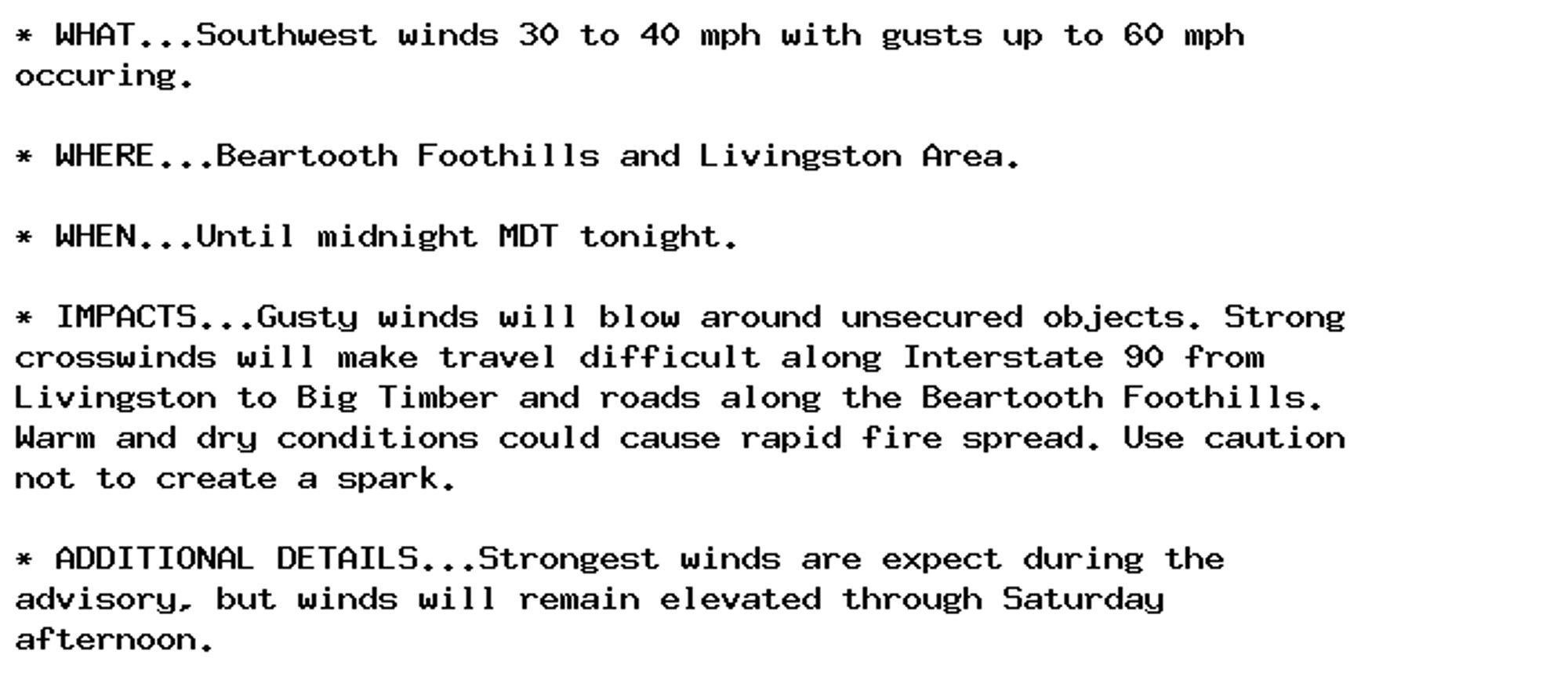
NEW WEATHER ADVISORY: Wind Advisory * WHAT...Southwest winds 30 to 40 mph with gusts up to 60 mph occuring. * WHERE...Beartooth Foothills and Livingston Area. * WHEN...Until midnight MDT tonight. * IMPACTS...Gusty winds will blow around unsecured... See more: watchedsky.social/app/alerts/...

0
AFfsd.nws-bot.us

🚨 Red Flag Warning issued October 4 at 7:41PM CDT until October 4 at 8:00PM CDT by NWS Sioux Falls SD 🚨 Additional Details Here.

* AFFECTED AREA...In South Dakota, Beadle, Gregory, Jerauld,
Sanborn, Brule, Aurora, Davison, Charles Mix and Douglas.

* WINDS...Southwest 15 to 25 mph with will turn to the west late
Saturday morning with gusts up to 45 mph.

* RELATIVE HUMIDITY...As low as 18 percent.

* IMPACTS...Any fires that develop will likely spread rapidly.
Outdoor burning is not recommended.
0
AFfsd.nws-bot.us

🚨 Red Flag Warning issued October 4 at 7:41PM CDT until October 5 at 8:00PM CDT by NWS Sioux Falls SD 🚨 Additional Details Here.

* AFFECTED AREA...In South Dakota, Beadle, Gregory, Jerauld,
Sanborn, Brule, Aurora, Davison, Charles Mix and Douglas.

* WINDS...Southwest 15 to 25 mph with will turn to the west late
Saturday morning with gusts up to 45 mph.

* RELATIVE HUMIDITY...As low as 18 percent.

* IMPACTS...Any fires that develop will likely spread rapidly.
Outdoor burning is not recommended.
0
NWskeetbot.watchedsky.social

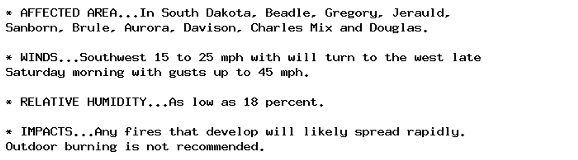
NEW WEATHER ADVISORY: Red Flag Warning * AFFECTED AREA...In South Dakota, Beadle, Gregory, Jerauld, Sanborn, Brule, Aurora, Davison, Charles Mix and Douglas. * WINDS...Southwest 15 to 25 mph with will turn to the west late Saturday morning with gusts... See more: watchedsky.social/app/alerts/...

0