BLUE

Strong to severe thunderstorms may produce large hail and isolated gusty/damaging winds across parts of northern Wisconsin and Michigan this evening and overnight. Please stay weather aware. #WeatherAwareDay#weather#wx#SPC#SevereWeather

Fire Danger Across the Central Rockies into the Plains; Late Season Heat Wave in the Southwest
A strong Pacific system is bringing strong winds and elevated to critical fire weather condition across portions of the Central Rockies into the Central and Northern Plains. Critical wildfire conditions are also expected across northern Wisconsin into the Upper Peninsula of Michigan. The heat wave continues across portions of California into the Southwest.
0

Severe thunderstorms are not expected through tonight. Please stay weather aware. #WeatherAwareDay#weather#wx#SPC#SevereWeather

Strong Bering Storm Impacting Portions of Alaska; Critical Fire Weather Conditions in the Great Basin and Northern Rockies
A strong Bering Sea storm will continue to impact the Aleutian Islands and parts of southwestern Alaska today. High Wind Warnings have been issued for the entire Aleutian Island chain. Across the Great Basin and northern Rockies, strong winds and dry conditions will lead to critical fire weather conditions today as a strong Pacific system moves inland.
0

Severe thunderstorms are not expected through tonight. Please stay weather aware. #WeatherAwareDay#weather#wx#SPC#SevereWeather

Strong Storm Approaching Alaska; Record Heat for Portions of the West; Watching the Tropics
Increasing dangerous surf, strong winds and heavy precipitation will affect southern portions of Alaska and Aleutian over the next few days. A strong system will move ashore across the Pacific Northwest with winds and increasing fire weather concerns for the northern Great Basin and Rockies. Extreme heat lingers for the Southwest and parts of California. Closely monitoring the Gulf of Mexico
0

Severe thunderstorms are not expected through tonight. Please stay weather aware. #WeatherAwareDay#weather#wx#SPC#SevereWeather

Critical Fire Weather Conditions in the North-Central U.S.; Excessive Heat in the Desert Southwest and Coastal California
A cold front pressing south across the northern and central Plains today will bring gusty winds creating critical fire weather for parts of the region. Red Flag Warnings and Fire Weather Watches have been issued. Dangerous heat continues in parts of the Desert Southwest through Friday. Excessive Heat Warnings are in effect for southwest Arizona into Nevada and large portion of coastal California.
0

Severe thunderstorms are not expected today. Please stay weather aware. #WeatherAwareDay#weather#wx#SPC#SevereWeather

Locally Heavy Rain for Mid-Atlantic and Central Florida; Fire Weather Concerns for the Plains; Heat Continues Out West
Locally heavy rainfall will affect portions of the mid-Atlantic today as residual tropical moisture moves through the region. For parts of Florida, increasing coverage of showers and thunderstorms may produce heavy rainfall along with warm and humid conditions. The heat will continue across portions of the West with new records expected. The Plains and northern Rockies, fire weather concerns today
0
LMcopacetic-vibe.bsky.social

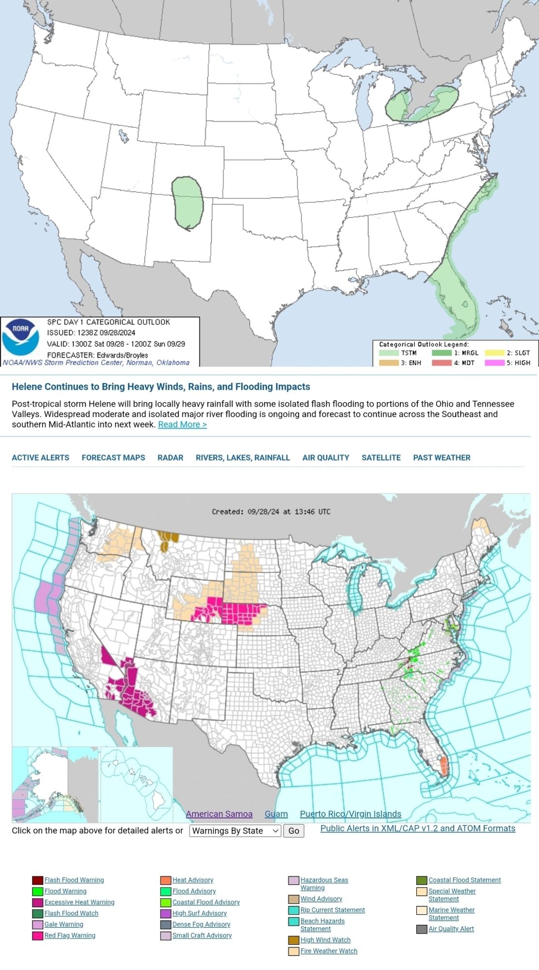
Severe thunderstorms are not expected today, though a few strong storms may affect central/eastern North Carolina. Please stay weather aware. #WeatherAwareDay#weather#wx#SPC#SevereWeather

Fire Weather Concerns for the Plains; Extreme Heat for Southwest; Heavy Rainfall for Mid-Atlantic

Strong winds, low humidity and dry fuels may allow for a rapid spread of fires across a large portion of the Central/Northern Plains today. For the Southwest into lower elevations of California, extreme heat will persist the next several days where new daily records are expected. For portions of the mid-Atlantic, pockets of heavy rainfall are expected today with isolated incidences of flooding.
1
LMcopacetic-vibe.bsky.social

Severe thunderstorms are not forecast for today. Please stay weather aware. #WeatherAwareDay#weather#wx#SPC#SevereWeather

Post-Tropical Cyclone Helene Continues to Weaken; Critical Fire Weather Concerns in the Plains
Post-Tropical Cyclone Helene continues to weaken; however, moderate to heavy rainfall and flooding will continue through Monday over parts of the Ohio/Tennessee Valleys and portions of the Appalachians and Mid-Atlantic States. Dry and windy conditions will support elevated to critical fire weather conditions over the next few days across portions of the northern and central Plains
1
LMcopacetic-vibe.bsky.social

Severe thunderstorms are not expected today. Please stay weather aware. #WeatherAwareDay#weather#wx#SPC#SevereWeather

Helene Continues to Bring Heavy Winds, Rains, and Flooding Impacts
Post-tropical storm Helene will bring locally heavy rainfall with some isolated flash flooding to portions of the Ohio and Tennessee Valleys. Widespread moderate and isolated major river flooding is ongoing and forecast to continue across the Southeast and southern Mid-Atlantic into next week.
0
LMcopacetic-vibe.bsky.social

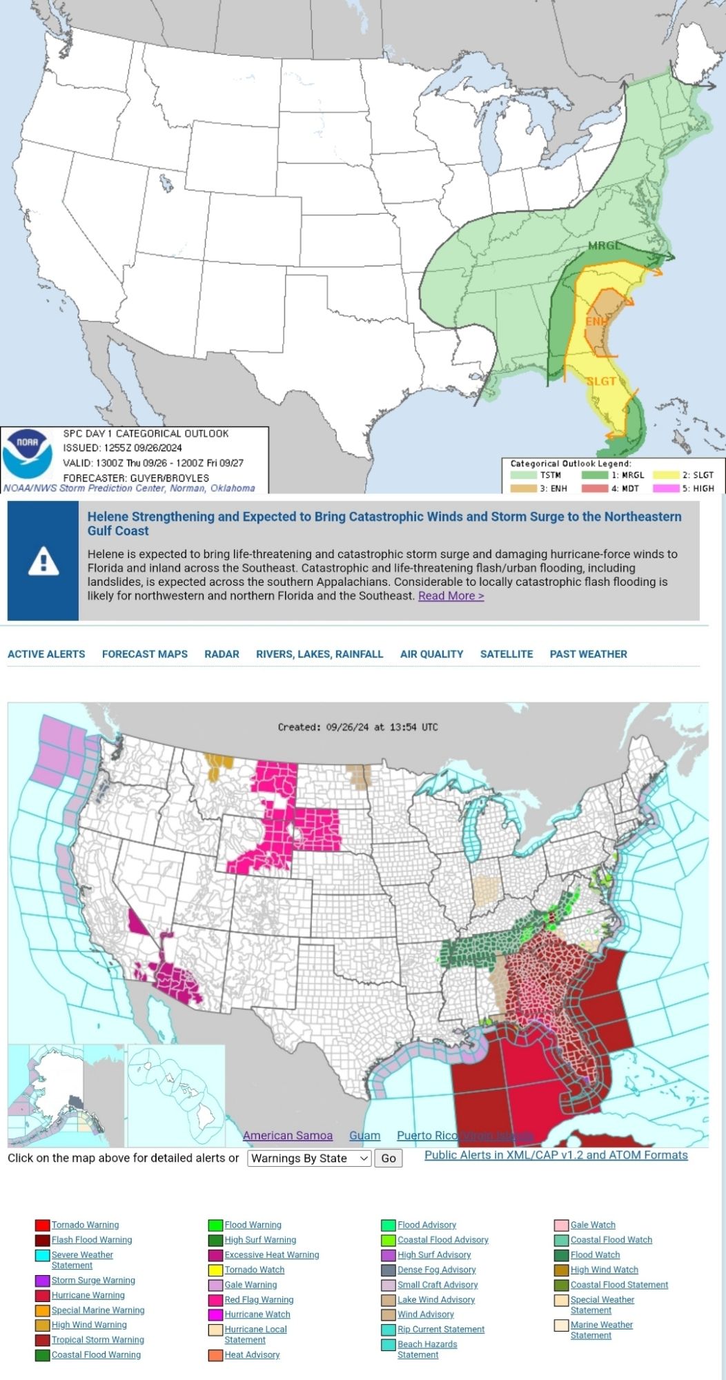
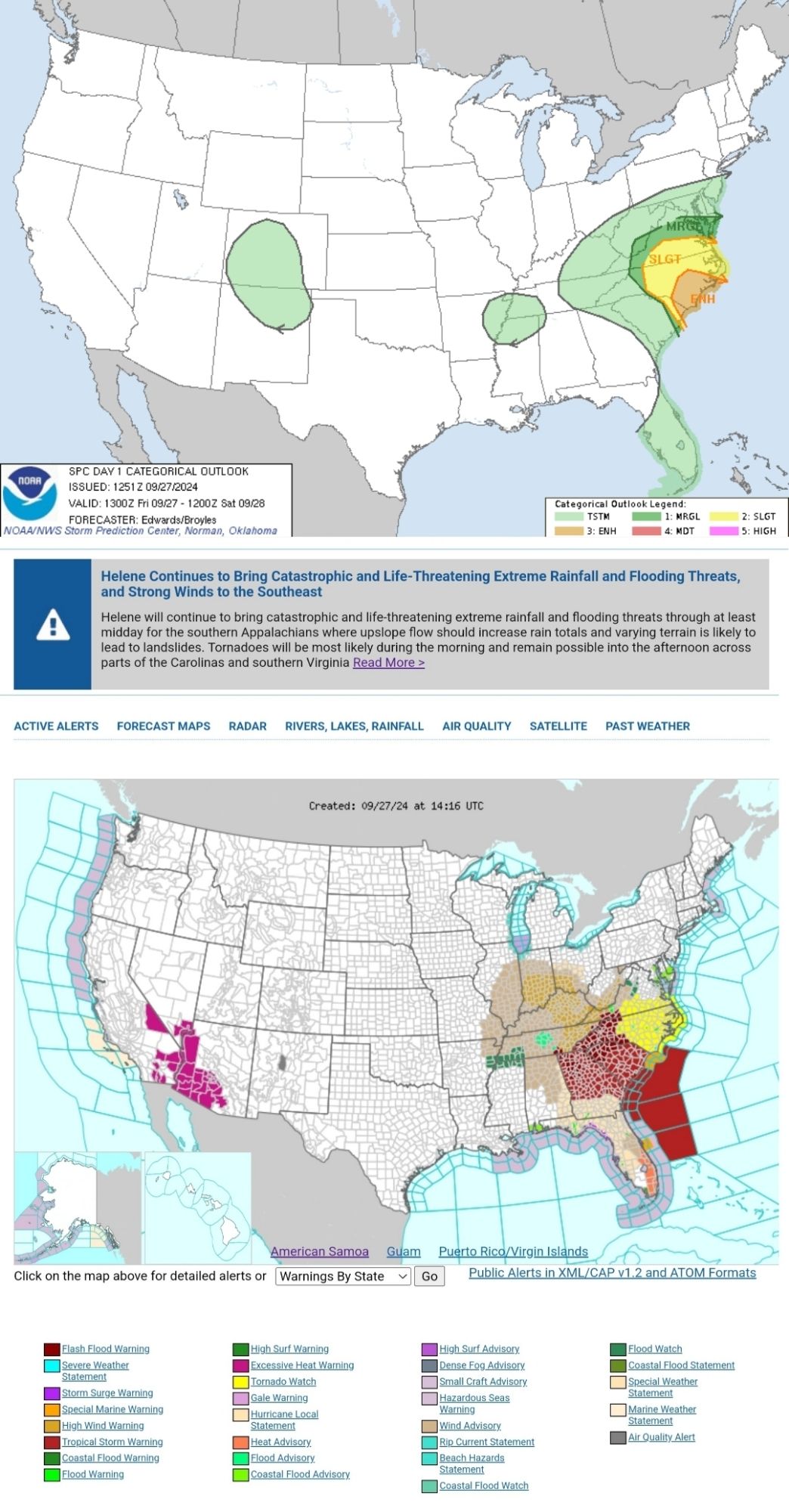
Tornadoes will be most likely through midday and remain possible into afternoon across parts of the Carolinas and Virginia. Please stay weather aware. #WeatherAwareDay#weather#wx#SPC#SevereWeather

Helene Continues to Bring Catastrophic and Life-Threatening Extreme Rainfall and Flooding Threats, and Strong Winds to the Southeast
Helene will continue to bring catastrophic and life-threatening extreme rainfall and flooding threats through at least midday for the southern Appalachians where upslope flow should increase rain totals and varying terrain is likely to lead to landslides. Tornadoes will be most likely during the morning and remain possible into the afternoon across parts of the Carolinas and southern Virginia
0
LMcopacetic-vibe.bsky.social

⚠️ Details in ALT Text ⚠️ Pay attention to local meteorologists and reliable weather apps if you live in a colored area on the top map. Stay updated on the weather in your area and be prepared with a plan for severe weather.  #WeatherAwareDay#weather#wx#SPC#WeatherAware#SevereWeather

Several tornadoes are expected today into tonight across the coastal Southeast in association with Hurricane Helene. The greatest threat is expected across parts of Florida into southeast Georgia, the Midlands and Low Country of South Carolina, and southern North Carolina. Please stay weather aware. #WeatherAwareDay #weather #wx #SPC #SevereWeather  
Helene Strengthening and Expected to Bring Catastrophic Winds and Storm Surge to the Northeastern Gulf Coast
Helene is expected to bring life-threatening and catastrophic storm surge and damaging hurricane-force winds to Florida and inland across the Southeast. Catastrophic and life-threatening flash/urban flooding, including landslides, is expected across the southern Appalachians. Considerable to locally catastrophic flash flooding is likely for northwestern and northern Florida and the Southeast
0