BLUE
NHnhc-atlc.nws-bot.us

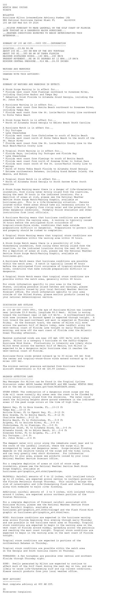
Atlantic Hurricane Milton Intermediate Advisory Number 16A issued at Wed, 09 Oct 2024 05:48:49 +0000 ...MILTON FORECAST TO MAKE LANDFALL ON THE GULF COAST OF FLORIDA LATE TONIGHT AS A DANGEROUS MAJOR HURRICANE... ...WEATHER CONDITIONS EXPECTED TO BEGIN DETERIORAT... Additional Details Here.


 <br />
 000<br />
 WTNT34 KNHC 090548<br />
 TCPAT4<br />
  <br />
 BULLETIN<br />
 Hurricane Milton Intermediate Advisory Number 16A<br />
 NWS National Hurricane Center Miami FL       AL142024<br />
 100 AM CDT Wed Oct 09 2024<br />
 <br />
 ...MILTON FORECAST TO MAKE LANDFALL ON THE GULF COAST OF FLORIDA<br />
 LATE TONIGHT AS A DANGEROUS MAJOR HURRICANE...<br />
 ...WEATHER CONDITIONS EXPECTED TO BEGIN DETERIORATING THIS <br />
 AFTERNOON...<br />
 <br />
  <br />
 SUMMARY OF 100 AM CDT...0600 UTC...INFORMATION<br />
 ----------------------------------------------<br />
 LOCATION...23.8N 86.0W<br />
 ABOUT 205 MI...330 KM WSW OF THE DRY TORTUGAS<br />
 ABOUT 360 MI...585 KM SW OF TAMPA FLORIDA<br />
 MAXIMUM SUSTAINED WINDS...160 MPH...260 KM/H<br />
 PRESENT MOVEMENT...NE OR 55 DEGREES AT 12 MPH...19 KM/H<br />
 MINIMUM CENTRAL PRESSURE...914 MB...26.99 INCHES<br />
  <br />
  <br />
 WATCHES AND WARNINGS<br />
 --------------------<br />
 CHANGES WITH THIS ADVISORY:<br />
  <br />
 None<br />
  <br />
 SUMMARY OF WATCHES AND WARNINGS IN EFFECT:<br />
  <br />
 A Storm Surge Warning is in effect for...<br />
 * Florida west coast from Flamingo northward to Suwannee River,<br />
 including Charlotte Harbor and Tampa Bay<br />
 * Sebastian Inlet Florida to Altamaha Sound Georgia, including the<br />
 St. Johns River<br />
  <br />
 A Hurricane Warning is in effect for...<br />
 * Florida west coast from Bonita Beach northward to Suwannee River,<br />
 including Tampa Bay<br />
 * Florida east coast from the St. Lucie/Martin County Line northward<br />
 to Ponte Vedra Beach<br />
  <br />
 A Storm Surge Watch is in effect for...<br />
 * North of Altamaha Sound Georgia to Edisto Beach South Carolina<br />
  <br />
 A Hurricane Watch is in effect for...<br />
 * Dry Tortugas<br />
 * Lake Okeechobee<br />
 * Florida west coast from Chokoloskee to south of Bonita Beach<br />
 * Florida east coast north of Ponte Vedra Beach to the mouth of the<br />
 St. Marys River<br />
 * Florida east coast from the St. Lucie/Martin County Line to the<br />
 Palm Beach/Martin County Line<br />
  <br />
 A Tropical Storm Warning is in effect for...<br />
 * Florida Keys, including Dry Tortugas and Florida Bay<br />
 * Lake Okeechobee<br />
 * Florida west coast from Flamingo to south of Bonita Beach<br />
 * Florida west coast from north of Suwanee River to Indian Pass<br />
 * Florida east coast south of the St. Lucie/Martin County Line to<br />
 Flamingo<br />
 * North of Ponte Vedra Beach Florida to Altamaha Sound Georgia<br />
 * Extreme northwestern Bahamas, including Grand Bahama Island, the<br />
 Abacos, and Bimini<br />
  <br />
 A Tropical Storm Watch is in effect for...<br />
 * North of Altamaha Sound Georgia to South Santee River South<br />
 Carolina<br />
  <br />
 A Storm Surge Warning means there is a danger of life-threatening<br />
 inundation, from rising water moving inland from the coastline,<br />
 during the next 36 hours in the indicated locations. For a<br />
 depiction of areas at risk, please see the National Weather<br />
 Service Storm Surge Watch/Warning Graphic, available at<br />
 hurricanes.gov.  This is a life-threatening situation.  Persons<br />
 located within these areas should take all necessary actions to<br />
 protect life and property from rising water and the potential for<br />
 other dangerous conditions.  Promptly follow evacuation and other<br />
 instructions from local officials.<br />
  <br />
 A Hurricane Warning means that hurricane conditions are expected<br />
 somewhere within the warning area.  A warning is typically issued<br />
 36 hours before the anticipated first occurrence of<br />
 tropical-storm-force winds, conditions that make outside<br />
 preparations difficult or dangerous.  Preparations to protect life<br />
 and property should be rushed to completion.<br />
  <br />
 A Tropical Storm Warning means that tropical storm conditions are<br />
 expected somewhere within the warning area within 36 hours.<br />
  <br />
 A Storm Surge Watch means there is a possibility of life-<br />
 threatening inundation, from rising water moving inland from the<br />
 coastline, in the indicated locations during the next 48 hours.<br />
 For a depiction of areas at risk, please see the National Weather<br />
 Service Storm Surge Watch/Warning Graphic, available at<br />
 hurricanes.gov.<br />
  <br />
 A Hurricane Watch means that hurricane conditions are possible<br />
 within the watch area.  A watch is typically issued 48 hours<br />
 before the anticipated first occurrence of tropical-storm-force<br />
 winds, conditions that make outside preparations difficult or<br />
 dangerous.<br />
  <br />
 A Tropical Storm Watch means that tropical storm conditions are<br />
 possible within the watch area, generally within 48 hours.<br />
  <br />
 For storm information specific to your area in the United<br />
 States, including possible inland watches and warnings, please<br />
 monitor products issued by your local National Weather Service<br />
 forecast office. For storm information specific to your area<br />
 outside of the United States, please monitor products issued by<br />
 your national meteorological service.<br />
  <br />
  <br />
 DISCUSSION AND OUTLOOK<br />
 ----------------------<br />
 At 100 AM CDT (0600 UTC), the eye of Hurricane Milton was located <br />
 near latitude 23.8 North, longitude 86.0 West.  Milton is moving <br />
 toward the northeast near 12 mph (19 km/h).  A northeastward motion <br />
 with some increase in forward speed is expected through tonight.  A <br />
 turn toward the east-northeast and east is expected on Thursday and <br />
 Friday.  On the forecast track, the center of Milton will move <br />
 across the eastern Gulf of Mexico today, make landfall along the <br />
 west-central coast of Florida late tonight or early Thursday <br />
 morning, and move off the east coast of Florida over the Atlantic <br />
 Ocean Thursday afternoon.<br />
  <br />
 Maximum sustained winds are near 160 mph (260 km/h) with higher<br />
 gusts.  Milton is a category 5 hurricane on the Saffir-Simpson<br />
 Hurricane Wind Scale.  Fluctuations in intensity are likely while<br />
 Milton moves across the eastern Gulf of Mexico, but Milton is<br />
 expected to be a dangerous major hurricane when it reaches the<br />
 west-central coast of Florida.<br />
  <br />
 Hurricane-force winds extend outward up to 30 miles (45 km) from<br />
 the center and tropical-storm-force winds extend outward up to 140<br />
 miles (220 km).<br />
  <br />
 The minimum central pressure estimated from Hurricane Hunter<br />
 aircraft observations is 914 mb (26.99 inches).<br />
  <br />
  <br />
 HAZARDS AFFECTING LAND<br />
 ----------------------<br />
 Key Messages for Milton can be found in the Tropical Cyclone<br />
 Discussion under AWIPS header MIATCDAT4 and WMO header WTNT44 KNHC<br />
 and on the web at hurricanes.gov/text/MIATCDAT4.shtml<br />
  <br />
 STORM SURGE: The combination of a dangerous storm surge and the<br />
 tide will cause normally dry areas near the coast to be flooded by<br />
 rising waters moving inland from the shoreline.  The water could<br />
 reach the following heights above ground somewhere in the indicated<br />
 areas if the peak surge occurs at the time of high tide...<br />
  <br />
 Egmont Key, FL to Boca Grande, FL...10-15 ft<br />
 Tampa Bay...10-15 ft<br />
 Anclote River, FL to Egmont Key, FL...9-13 ft<br />
 Boca Grande, FL to Bonita Beach, FL...8-12 ft<br />
 Charlotte Harbor...8-12 ft<br />
 Bonita Beach, FL to Chokoloskee, FL...5-8 ft<br />
 Aripeka, FL to Anclote River, FL...5-8 ft<br />
 Chokoloskee, FL to Flamingo, FL...3-5 ft<br />
 Sebastian Inlet, FL to Altamaha Sound, GA...3-5 ft<br />
 Altamaha Sound, GA to Edisto Beach, SC...2-4 ft<br />
 Suwannee River, FL to Aripeka, FL...2-4 ft<br />
 Dry Tortugas...2-4 ft<br />
 St. Johns River...2-4 ft<br />
  <br />
 The deepest water will occur along the immediate coast near and to<br />
 the south of the landfall location, where the surge will be<br />
 accompanied by large and dangerous waves.  Surge-related flooding<br />
 depends on the relative timing of the surge and the tidal cycle,<br />
 and can vary greatly over short distances.  For information<br />
 specific to your area, please see products issued by your local<br />
 National Weather Service forecast office.<br />
  <br />
 For a complete depiction of areas at risk of storm surge<br />
 inundation, please see the National Weather Service Peak Storm<br />
 Surge Graphic, available at<br />
 hurricanes.gov/graphics_at4.shtml?peakSurge.<br />
  <br />
 RAINFALL: Rainfall amounts of 6 to 12 inches, with localized totals<br />
 up to 18 inches, are expected across central to northern portions of<br />
 the Florida Peninsula through Thursday.  This rainfall brings the<br />
 risk of catastrophic and life-threatening flash and urban flooding,<br />
 along with moderate to major river flooding.<br />
  <br />
 Additional rainfall amounts of  2 to 4 inches, with isolated totals<br />
 around 6 inches, are expected across northern portions of the<br />
 Yucatan Peninsula.<br />
  <br />
 For a complete depiction of forecast rainfall associated with<br />
 Hurricane Milton, please see the National Weather Service Storm<br />
 Total Rainfall Graphic, available at<br />
 hurricanes.gov/graphics_at4.shtml?rainqpf and the Flash Flood Risk<br />
 graphic at hurricanes.gov/graphics_at4.shtml?ero.<br />
  <br />
 WIND: Hurricane conditions are expected in the hurricane warning <br />
 area across Florida beginning this evening through early Thursday <br />
 and are possible in the hurricane watch area on Thursday. Tropical <br />
 storm conditions are expected to begin in the warning area on the <br />
 west coast of Florida around midday, spreading across the peninsula <br />
 and reaching the east coast tonight. Tropical storm conditions are <br />
 expected to begin in the warning area on the east coast of Florida <br />
 tonight.<br />
  <br />
 Tropical storm conditions are expected in portions of the<br />
 northwestern Bahamas on Thursday.<br />
  <br />
 Tropical storm conditions are possible within the watch area<br />
 on the Georgia and South Carolina coasts on Thursday.<br />
  <br />
 TORNADOES: A few tornadoes are possible over central and southern<br />
 Florida through Thursday night.<br />
  <br />
 SURF:  Swells generated by Milton are expected to continue to<br />
 affect much of the Gulf Coast during the next day or two, and are<br />
 likely to cause life-threatening surf and rip current conditions.<br />
 Please consult products from your local weather office.<br />
  <br />
  <br />
 NEXT ADVISORY<br />
 -------------<br />
 Next complete advisory at 400 AM CDT.<br />
  <br />
 $$<br />
 Forecaster Cangialosi<br />
  <br />
Hurricane Milton 5-Day Uncertainty Track Image
Hurricane Milton 34-Knot Wind Speed Probabilities
Hurricane Milton Probabilistic Storm Surge Graphics Image
0
AFjax.nws-bot.us

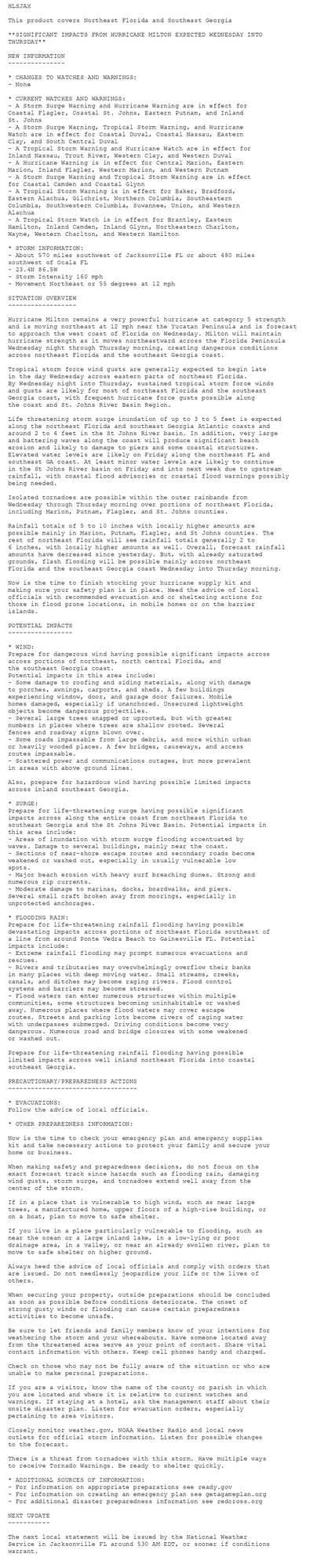
Tropical Cyclone Statement issued October 8 at 11:31PM EDT by NWS Jacksonville FL Additional Details Here.

HLSJAX

This product covers Northeast Florida and Southeast Georgia

**SIGNIFICANT IMPACTS FROM HURRICANE MILTON EXPECTED WEDNESDAY INTO
THURSDAY**

NEW INFORMATION
---------------

* CHANGES TO WATCHES AND WARNINGS:
- None

* CURRENT WATCHES AND WARNINGS:
- A Storm Surge Warning and Hurricane Warning are in effect for
Coastal Flagler, Coastal St. Johns, Eastern Putnam, and Inland
St. Johns
- A Storm Surge Warning, Tropical Storm Warning, and Hurricane
Watch are in effect for Coastal Duval, Coastal Nassau, Eastern
Clay, and South Central Duval
- A Tropical Storm Warning and Hurricane Watch are in effect for
Inland Nassau, Trout River, Western Clay, and Western Duval
- A Hurricane Warning is in effect for Central Marion, Eastern
Marion, Inland Flagler, Western Marion, and Western Putnam
- A Storm Surge Warning and Tropical Storm Warning are in effect
for Coastal Camden and Coastal Glynn
- A Tropical Storm Warning is in effect for Baker, Bradford,
Eastern Alachua, Gilchrist, Northern Columbia, Southeastern
Columbia, Southwestern Columbia, Suwannee, Union, and Western
Alachua
- A Tropical Storm Watch is in effect for Brantley, Eastern
Hamilton, Inland Camden, Inland Glynn, Northeastern Charlton,
Wayne, Western Charlton, and Western Hamilton

* STORM INFORMATION:
- About 570 miles southwest of Jacksonville FL or about 480 miles
southwest of Ocala FL
- 23.4N 86.5W
- Storm Intensity 160 mph
- Movement Northeast or 55 degrees at 12 mph

SITUATION OVERVIEW
------------------

Hurricane Milton remains a very powerful hurricane at category 5 strength
and is moving northeast at 12 mph near the Yucatan Peninsula and is forecast
to approach the west coast of Florida on Wednesday. Milton will maintain
hurricane strength as it moves northeastward across the Florida Peninsula
Wednesday night through Thursday morning, creating dangerous conditions
across northeast Florida and the southeast Georgia coast.

Tropical storm force wind gusts are generally expected to begin late
in the day Wednesday across eastern parts of northeast Florida.
By Wednesday night into Thursday, sustained tropical storm force winds
and gusts are likely for most of northeast Florida and the southeast
Georgia coast, with frequent hurricane force gusts possible along
the coast and St. Johns River Basin Region.

Life threatening storm surge inundation of up to 3 to 5 feet is expected
along the northeast Florida and southeast Georgia Atlantic coasts and
around 2 to 4 feet in the St Johns River basin. In addition, very large
and battering waves along the coast will produce significant beach
erosion and likely to damage to piers and some coastal structures.
Elevated water levels are likely on Friday along the northeast FL and
southeast GA coast. At least minor water levels are likely to continue
in the St Johns River basin on Friday and into next week due to upstream
rainfall, with coastal flood advisories or coastal flood warnings possibly
being needed.

Isolated tornadoes are possible within the outer rainbands from
Wednesday through Thursday morning over portions of northeast Florida,
including Marion, Putnam, Flagler, and St. Johns counties.

Rainfall totals of 5 to 10 inches with locally higher amounts are
possible mainly in Marion, Putnam, Flagler, and St Johns counties. The
rest of northeast Florida will see rainfall totals generally 2 to
6 inches, with locally higher amounts as well. Overall, forecast rainfall
amounts have decreased since yesterday. But, with already saturated
grounds, flash flooding will be possible mainly across northeast
Florida and the southeast Georgia coast Wednesday into Thursday morning.

Now is the time to finish stocking your hurricane supply kit and
making sure your safety plan is in place. Heed the advice of local
officials with recommended evacuation and or sheltering actions for
those in flood prone locations, in mobile homes or on the barrier
islands.

POTENTIAL IMPACTS
-----------------

* WIND:
Prepare for dangerous wind having possible significant impacts across
across portions of northeast, north central Florida, and
the southeast Georgia coast.
Potential impacts in this area include:
- Some damage to roofing and siding materials, along with damage
to porches, awnings, carports, and sheds. A few buildings
experiencing window, door, and garage door failures. Mobile
homes damaged, especially if unanchored. Unsecured lightweight
objects become dangerous projectiles.
- Several large trees snapped or uprooted, but with greater
numbers in places where trees are shallow rooted. Several
fences and roadway signs blown over.
- Some roads impassable from large debris, and more within urban
or heavily wooded places. A few bridges, causeways, and access
routes impassable.
- Scattered power and communications outages, but more prevalent
in areas with above ground lines.

Also, prepare for hazardous wind having possible limited impacts
across inland southeast Georgia.

* SURGE:
Prepare for life-threatening surge having possible significant
impacts across along the entire coast from northeast Florida to
southeast Georgia and the St Johns River Basin. Potential impacts in
this area include:
- Areas of inundation with storm surge flooding accentuated by
waves. Damage to several buildings, mainly near the coast.
- Sections of near-shore escape routes and secondary roads become
weakened or washed out, especially in usually vulnerable low
spots.
- Major beach erosion with heavy surf breaching dunes. Strong and
numerous rip currents.
- Moderate damage to marinas, docks, boardwalks, and piers.
Several small craft broken away from moorings, especially in
unprotected anchorages.

* FLOODING RAIN:
Prepare for life-threatening rainfall flooding having possible
devastating impacts across portions of northeast Florida southeast of
a line from around Ponte Vedra Beach to Gainesville FL. Potential
impacts include:
- Extreme rainfall flooding may prompt numerous evacuations and
rescues.
- Rivers and tributaries may overwhelmingly overflow their banks
in many places with deep moving water. Small streams, creeks,
canals, and ditches may become raging rivers. Flood control
systems and barriers may become stressed.
- Flood waters can enter numerous structures within multiple
communities, some structures becoming uninhabitable or washed
away. Numerous places where flood waters may cover escape
routes. Streets and parking lots become rivers of raging water
with underpasses submerged. Driving conditions become very
dangerous. Numerous road and bridge closures with some weakened
or washed out.

Prepare for life-threatening rainfall flooding having possible
limited impacts across well inland northeast Florida into coastal
southeast Georgia.

PRECAUTIONARY/PREPAREDNESS ACTIONS
----------------------------------

* EVACUATIONS:
Follow the advice of local officials.

* OTHER PREPAREDNESS INFORMATION:

Now is the time to check your emergency plan and emergency supplies
kit and take necessary actions to protect your family and secure your
home or business.

When making safety and preparedness decisions, do not focus on the
exact forecast track since hazards such as flooding rain, damaging
wind gusts, storm surge, and tornadoes extend well away from the
center of the storm.

If in a place that is vulnerable to high wind, such as near large
trees, a manufactured home, upper floors of a high-rise building, or
on a boat, plan to move to safe shelter.

If you live in a place particularly vulnerable to flooding, such as
near the ocean or a large inland lake, in a low-lying or poor
drainage area, in a valley, or near an already swollen river, plan to
move to safe shelter on higher ground.

Always heed the advice of local officials and comply with orders that
are issued. Do not needlessly jeopardize your life or the lives of
others.

When securing your property, outside preparations should be concluded
as soon as possible before conditions deteriorate. The onset of
strong gusty winds or flooding can cause certain preparedness
activities to become unsafe.

Be sure to let friends and family members know of your intentions for
weathering the storm and your whereabouts. Have someone located away
from the threatened area serve as your point of contact. Share vital
contact information with others. Keep cell phones handy and charged.

Check on those who may not be fully aware of the situation or who are
unable to make personal preparations.

If you are a visitor, know the name of the county or parish in which
you are located and where it is relative to current watches and
warnings. If staying at a hotel, ask the management staff about their
onsite disaster plan. Listen for evacuation orders, especially
pertaining to area visitors.

Closely monitor weather.gov, NOAA Weather Radio and local news
outlets for official storm information. Listen for possible changes
to the forecast.

There is a threat from tornadoes with this storm. Have multiple ways
to receive Tornado Warnings. Be ready to shelter quickly.

* ADDITIONAL SOURCES OF INFORMATION:
- For information on appropriate preparations see ready.gov
- For information on creating an emergency plan see getagameplan.org
- For additional disaster preparedness information see redcross.org

NEXT UPDATE
-----------

The next local statement will be issued by the National Weather
Service in Jacksonville FL around 530 AM EDT, or sooner if conditions
warrant.
1
AFtlh.nws-bot.us

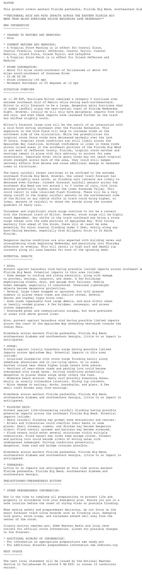
Tropical Cyclone Statement issued October 8 at 11:18PM EDT by NWS Tallahassee FL Additional Details Here.

HLSTAE

This product covers eastern Florida panhandle, Florida Big Bend, southeastern Alabama and southwestern Georgia

**PERIPHERAL RAIN AND WIND IMPACTS ACROSS THE EASTERN FLORIDA BIG
BEND FROM MAJOR HURRICANE MILTON BEGINNING LATE WEDNESDAY**

NEW INFORMATION
---------------

* CHANGES TO WATCHES AND WARNINGS:
- None

* CURRENT WATCHES AND WARNINGS:
- A Tropical Storm Warning is in effect for Coastal Dixie,
Coastal Franklin, Coastal Jefferson, Coastal Taylor, Coastal
Wakulla, Inland Dixie, Inland Taylor, and Lafayette
- A Tropical Storm Watch is in effect for Inland Jefferson and
Madison

* STORM INFORMATION:
- About 510 miles south-southwest of Tallahassee or about 460
miles south-southwest of Suwannee River
- 23.4N 86.5W
- Storm Intensity 160 mph
- Movement Northeast or 55 degrees at 12 mph

SITUATION OVERVIEW
------------------

At 11 PM EDT, Hurricane Milton remained a category 5 hurricane over
extreme southeast Gulf of Mexico while moving east-northeastward.
Milton is still forecast to be a large, dangerous major hurricane when
it makes landfall along the west-central coast of Florida Wednesday
might. However, locally we will only have peripheral impacts from wind
and rain, and even these impacts have lessened further as the track
has shifted slightly south.

Milton's forecast large size will be the result of an interaction with
a cold front moving southeast over the Florida Panhandle. This
expansion in the wind field will help to increase winds on the
northwest side of the circulation. While the probabilities for
tropical storm force winds have decreased markedly over the last
30 hours, tropical storm conditions are still likely across the
Apalachee Bay coastline. Although confidence is lower in these winds
across inland areas in the southeast portions of the Florida Big Bend
in and east of Jefferson County, Florida, tropical storm watches and
warnings remain in place with this advisory to account for some
uncertainty. Important Note: while gusty winds may not reach tropical
storm strength across much of the area, they could still hamper
recovery efforts from Helene and cause additional damage to weakened
trees or structures.

The heavy rainfall threat continues to be confined to the extreme
southeast Florida Big Bend. However, the latest track forecast has
shifted slightly more south, so flooding rain concerns are likely to
decrease even further. Current forecast rainfall amounts across the
southeast Big Bend are now around 1 to 3 inches of rain, with local
amounts potentially higher across the lower Suwannee Valley. This
could result in some localized flash flooding. There will be a very
sharp cutoff in the higher rainfall amounts on the northwestern side
of the Milton so any subtle shifts in track could bring higher, or
lower, amounts of rainfall to those who reside along the current
gradient of heavy rain.

Tornadoes and significant storm surge continue to not be a concern
with the forecast track of Milton. However, storm surge will be highly
track dependent. Any shifts in the track northward may bring a storm
surge threat into the some portions of Apalachee Bay. With strong
easterly flow ahead of the storm, there will at least be some
potential for minor coastal flooding under 3 feet, mostly along any
east-facing beaches, especially from Alligator Point to St Marks
Florida.

Dangerous marine conditions are also expected with building waves and
strengthening winds beginning Wednesday and persisting into Thursday
afternoon or evening. This will result in high surf and deadly rip
currents along all area beaches for much of the upcoming week.

POTENTIAL IMPACTS
-----------------

* WIND:
Protect against hazardous wind having possible limited impacts across southeast and coastal
Florida Big Bend. Potential impacts in this area include:
- Some damage to roofing and siding materials, along with damage
to porches, awnings, carports, and sheds. A few buildings
experiencing window, door, and garage door failures. Mobile
homes damaged, especially if unanchored. Unsecured lightweight
objects become dangerous projectiles.
- Several large trees snapped or uprooted, but with greater
numbers in places where trees are shallow rooted. Several
fences and roadway signs blown over.
- Some roads impassable from large debris, and more within urban
or heavily wooded places. A few bridges, causeways, and access
routes impassable.
- Scattered power and communications outages, but more prevalent
in areas with above ground lines.

Also, protect against hazardous wind having possible limited impacts
across the coast of the Apalachee Bay extending westwards towards the
Indian Pass.

Elsewhere across eastern Florida panhandle, Florida Big Bend,
southeastern Alabama and southwestern Georgia, little to no impact is
anticipated.

* SURGE:
Protect against locally hazardous surge having possible limited
impacts across Apalachee Bay. Potential impacts in this area
include:
- Localized inundation with storm surge flooding mainly along
immediate shorelines and in low-lying spots, or in areas
farther inland near where higher surge waters move ashore.
- Sections of near-shore roads and parking lots could become
overspread with surge water. Driving conditions potentially
dangerous in places where surge water covers the road.
- Moderate beach erosion. Heavy surf possibly breaching dunes,
mainly in usually vulnerable locations. Strong rip currents.
- Minor damage to marinas, docks, boardwalks, and piers. A few
small craft broken away from moorings.

Elsewhere across eastern Florida panhandle, Florida Big Bend,
southeastern Alabama and southwestern Georgia, little to no impact is
anticipated.

* FLOODING RAIN:
Protect against life-threatening rainfall flooding having possible
extensive impacts across the southeast Florida Big Bend. Potential
impacts include:
- Heavy rainfall flooding may prompt some evacuations and rescues.
- Rivers and tributaries could overflow their banks in some
places. Small streams, creeks, and ditches may become dangerous
rivers. Flood control systems and barriers may become stressed.
- Flood waters could enter several structures within multiple
communities. Flood waters may cover some escape routes. Streets
and parking lots could become rivers of moving water with
underpasses submerged. Driving conditions potentially
dangerous. Some road and bridge closures possible.

Elsewhere across eastern Florida panhandle, Florida Big Bend,
southeastern Alabama and southwestern Georgia, little to no impact is
anticipated.

* TORNADOES:
Little to no impacts are anticipated at this time across eastern
Florida panhandle, Florida Big Bend, southeastern Alabama and
southwestern Georgia.

PRECAUTIONARY/PREPAREDNESS ACTIONS
----------------------------------

* OTHER PREPAREDNESS INFORMATION:

Now is the time to complete all preparations to protect life and
property in accordance with your emergency plan. Ensure you are in a
safe location before the onset of strong winds or possible flooding.

When making safety and preparedness decisions, do not focus on the
exact forecast track since hazards such as flooding rain, damaging
wind gusts, storm surge, and tornadoes extend well away from the
center of the storm.

Closely monitor weather.gov, NOAA Weather Radio and local news
outlets for official storm information. Listen for possible changes
to the forecast.

* ADDITIONAL SOURCES OF INFORMATION:
- For information on appropriate preparations see ready.gov
- For additional disaster preparedness information see redcross.org

NEXT UPDATE
-----------

The next local statement will be issued by the National Weather
Service in Tallahassee FL around 5 AM EDT, or sooner if conditions
warrant.
0
AFmlb.nws-bot.us

Tropical Cyclone Statement issued October 8 at 11:26PM EDT by NWS Melbourne FL Additional Details Here.

HLSMLB

This product covers East Central Florida

**CONDITIONS DETERIORATE WEDNESDAY AS MILTON APPROACHES FLORIDA**

**HURRICANE FORCE WINDS, SIGNIFICANT TO DEVASTATING FLOODING NEAR AND
NORTH OF MILTON'S CENTER**

NEW INFORMATION
---------------

* CHANGES TO WATCHES AND WARNINGS:
- None

* CURRENT WATCHES AND WARNINGS:
- A Storm Surge Warning and Hurricane Warning are in effect for
Coastal Volusia, Northern Brevard Barrier Islands, and Southern
Brevard Barrier Islands
- A Hurricane Warning is in effect for Coastal Indian River,
Coastal Saint Lucie, Inland Indian River, Inland Northern
Brevard, Inland Saint Lucie, Inland Southern Brevard, Inland
Volusia, Mainland Northern Brevard, Mainland Southern Brevard,
Northern Lake, Okeechobee, Orange, Osceola, Seminole, and
Southern Lake
- A Tropical Storm Warning and Hurricane Watch are in effect for
Coastal Martin and Inland Martin

* STORM INFORMATION:
- About 480 miles southwest of Orlando FL
- 23.4N 86.5W
- Storm Intensity 160 mph
- Movement Northeast or 55 degrees at 12 mph

SITUATION OVERVIEW
------------------

As of 11 PM, Major Hurricane Milton was located in the southeastern
Gulf of Mexico just north of the Yucatan Channel. Milton has picked up
forward momentum and is moving to the northeast around 12 mph,
remaining an extremely dangerous category 5 hurricane with maximum
sustained winds of 160 mph and a minimum central pressure of 915 mb.

Milton will continue moving northeast across the southeastern Gulf of
Mexico tonight and Wednesday. Milton is forecast to make landfall
along the Florida west coast late Wednesday night, crossing the
eastern side of the peninsula Thursday morning and afternoon, then
moving offshore into the Atlantic. There will be multiple, significant
hazards posed by Milton as it moves over east central Florida.

Hurricane Warnings remain in effect for all of east central Florida,
except Martin county, where a Hurricane Watch and Tropical Storm
Warning are in effect. Final preparations should be rushed to
completion by early Wednesday morning before conditions deteriorate
through the day on Wednesday.

Wind: Outer rainbands from Hurricane Milton are expected to arrive on
Wednesday. Wednesday night into Thursday morning, winds will
strengthen to tropical storm force with gusts to hurricane force along
Milton's path, with a swath of sustained hurricane force winds
possible near the center of the storm. These winds will knock down
trees and power lines, leading to power outages. All east central
Florida residents and visitors should be in a safe shelter before
conditions become hazardous.

Heavy Rain: Ahead of Milton, deep moisture and onshore flow will
continue the potential for heavy rainfall tonight, with the highest
risk for flooding along the coast. Rainfall directly associated with
Hurricane Milton will increase in coverage and intensity through the
day Wednesday and into the night, as rainbands reach east central
Florida. Significant rainfall and flash flooding potential will
develop into Thursday morning, especially near and along the
I-4 corridor and the Greater Orlando area.

Between 6 to 12 inches of rainfall is forecast across east central
Florida, with a swath of 10 to 15 inches possible along the
I-4 corridor. Farther south, the forecast calls for 3 to 6 inches of
rain. These amounts, along with instances of higher rainfall rates,
will be capable of producing significant, potentially devastating
flooding. Heavy rainfall will also cause rapid rises on area creeks
and streams. The Saint Johns River at Astor, which is already
approaching Moderate Flood Stage, is forecast to rise quickly to Major
Flood Stage by Thursday morning. Additional points upstream on the
Saint Johns are also likely to experience rises to at least Minor or
Moderate flood stage.

Tornadoes: In addition to damaging wind gusts, tornadoes embedded in
rainbands are possible, mainly from Wednesday afternoon into Thursday
morning. Residents and visitors should have multiple ways of receiving
severe weather alerts.

Beach and Coastal Hazards: Along the coast, there is the potential for
significant beach and dune erosion from coastal storm surge. This
threat exists especially near and north of where Milton tracks. After
Milton moves offshore Thursday, strong northerly winds are expected,
elevating water levels along the Atlantic coast. Storm surge is
forecast to reach 3 to 5 feet above normally dry ground in areas along
the immediate Volusia and Brevard County coastlines, with dune erosion
likely. A Storm Surge Warning is in effect for all Brevard Barrier
Islands and Coastal Volusia County.

Up to 3 feet of storm surge will be possible along the Treasure Coast.
Higher water levels will continue into Friday along the Atlantic
beaches.

Heed the advice of local officials with recommended evacuation and or
sheltering actions for those in flood prone locations, mobile homes,
or on the barrier islands.

Continue to monitor the latest forecasts from the National Hurricane
Center and National Weather Service in Melbourne, Florida.

POTENTIAL IMPACTS
-----------------

* FLOODING RAIN:
Protect against life-threatening rainfall flooding having possible
devastating impacts from near Kissimmee to Titusville northward,
especially along the I-4 corridor. Potential impacts include:
- Extreme rainfall flooding may prompt numerous evacuations and
rescues.
- Rivers and tributaries may overwhelmingly overflow their banks
in many places with deep moving water. Small streams, creeks,
canals, and ditches may become raging rivers. In mountain
areas, deadly runoff may rage down valleys while increasing
susceptibility to rockslides and mudslides. Flood control
systems and barriers may become stressed.
- Flood waters can enter numerous structures within multiple
communities, some structures becoming uninhabitable or washed
away. Numerous places where flood waters may cover escape
routes. Streets and parking lots become rivers of raging water
with underpasses submerged. Driving conditions become very
dangerous. Numerous road and bridge closures with some weakened
or washed out.

Protect against life-threatening rainfall flooding having possible
significant to extensive impacts across across the southern half of
east-central Florida.

* WIND:
Protect against life-threatening wind having possible extensive impacts
along and south of the I-4 corridor, to Okeechobee and Saint Lucie
counties. Potential impacts in this area include:
- Considerable roof damage to sturdy buildings, with some having
window, door, and garage door failures leading to structural
damage. Mobile homes severely damaged, with some destroyed.
Damage accentuated by airborne projectiles. Locations may be
uninhabitable for weeks.
- Many large trees snapped or uprooted along with fences and
roadway signs blown over.
- Some roads impassable from large debris, and more within urban
or heavily wooded places. Several bridges, causeways, and
access routes impassable.
- Large areas with power and communications outages.

Also, protect against dangerous wind having possible significant
impacts across the remainder of east-central Florida.

* TORNADOES:
Protect against a dangerous tornado event having possible significant
impacts across East Central Florida. Potential impacts include:
- The occurrence of scattered tornadoes can hinder the execution
of emergency plans during tropical events.
- Several places may experience tornado damage with a few spots
of considerable damage, power loss, and communications failures.
- Locations could realize roofs torn off frame houses, mobile
homes demolished, boxcars overturned, large trees snapped or
uprooted, vehicles tumbled, and small boats tossed about.
Dangerous projectiles can add to the toll.

* SURGE:
Protect against life-threatening surge having possible significant
impacts across the immediate Volusia and Brevard County coastlines.
Potential impacts in this area include:
- Areas of inundation with storm surge flooding accentuated by
waves. Damage to several buildings, mainly near the coast.
- Sections of near-shore escape routes and secondary roads become
weakened or washed out, especially in usually vulnerable low
spots.
- Major beach erosion with heavy surf breaching dunes. Strong and
numerous rip currents.
- Moderate damage to marinas, docks, boardwalks, and piers.
Several small craft broken away from moorings, especially in
unprotected anchorages.

PRECAUTIONARY/PREPAREDNESS ACTIONS
----------------------------------

* EVACUATIONS:
Follow the advice of local officials.

* OTHER PREPAREDNESS INFORMATION:

When making safety and preparedness decisions, do not focus on the
exact forecast track since hazards such as flooding rain, damaging wind
gusts, storm surge, and tornadoes extend well away from the center of
the storm.

If you live in a place particularly vulnerable to flooding, such as
near the ocean or a large inland lake, in a low-lying or poor drainage
area, in a valley, or near an already swollen river, plan to move to
safe shelter on higher ground.

Be sure to let friends and family members know of your intentions for
weathering the storm and your whereabouts. Have someone located away
from the threatened area serve as your point of contact. Share vital
contact information with others.

Always heed the advice of local officials and comply with orders that
are issued. Do not needlessly jeopardize your life or the lives of
others.

* ADDITIONAL SOURCES OF INFORMATION:
- For information on appropriate preparations see ready.gov
- For information on creating an emergency plan see getagameplan.org
- For additional disaster preparedness information see redcross.org

NEXT UPDATE
-----------

The next local statement will be issued by the National Weather
Service in Melbourne FL around 6 AM EDT, or sooner if conditions
warrant.
0
AFmia.nws-bot.us

Tropical Cyclone Statement issued October 8 at 10:59PM EDT by NWS Miami FL Additional Details Here.

HLSMFL

This product covers South Florida

**Milton Remains Extremely Dangerous as it Moves Through the
Southeast Gulf**

NEW INFORMATION
---------------

* CHANGES TO WATCHES AND WARNINGS:
- None

* CURRENT WATCHES AND WARNINGS:
- A Storm Surge Warning, Tropical Storm Warning, and Hurricane
Watch are in effect for Coastal Collier County
- A Tropical Storm Warning and Hurricane Watch are in effect for
Glades, Hendry, and Inland Collier County
- A Storm Surge Warning and Tropical Storm Warning are in effect
for Mainland Monroe
- A Tropical Storm Warning is in effect for Coastal Broward
County, Coastal Miami Dade County, Coastal Palm Beach County,
Far South Miami-Dade County, Inland Broward County, Inland
Miami-Dade County, Inland Palm Beach County, Metro Broward
County, Metro Palm Beach County, and Metropolitan Miami Dade

* STORM INFORMATION:
- About 430 miles west-southwest of Miami FL or about 350 miles
west-southwest of Naples FL
- 23.4N 86.5W
- Storm Intensity 160 mph
- Movement Northeast or 55 degrees at 12 mph

SITUATION OVERVIEW
------------------

Hurricane Milton remains a major hurricane over the southeastern
Gulf of Mexico. It is forecast to remain at or near major hurricane
strength as it approaches the Gulf Coast of Florida late Wednesday.

The following are the primary hazards of concern with Hurricane Milton
for South Florida:

* Storm Surge - There is an increasing risk of dangerous storm surge
for portions of the Florida Gulf Coast. 5 to 8 feet of storm surge
over portions of coastal Collier County and 3 to 5 feet over portions
of Mainland Monroe County Wednesday afternoon into Thursday.

* Wind - The highest probabilities for sustained hurricane and
tropical storm force winds will be along the Gulf Coast of Southwest
Florida, including Glades, Hendry and Collier Counties, as well as the
adjacent Gulf waters. Tropical storm force winds are expected across
the rest of South Florida, including the Atlantic Coast and adjacent
Atlantic waters, especially in conjunction with Milton's rainbands.
The peak of the winds will generally occur on Wednesday night into
Thursday.

* Tornadoes - Several tornadoes will be possible tonight through early
Thursday morning, with the highest chances across portions of the
western Florida Peninsula.

* Rainfall - Heavy rainfall leading to possible flooding is expected
across South Florida through Thursday. 1 to 3 inches of additional
rainfall is possible through this time period with highest totals
across coastal Southwest Florida. Isolated locations could experience
up to 5 inches with the heavier rain. A Flood Watch is in effect for
the entire area through Thursday morning. Flash Flooding cannot be
ruled out.

POTENTIAL IMPACTS
-----------------

* SURGE:
Protect against life-threatening surge having possible extensive
impacts across coastal Southwest Florida. Potential impacts in this
area include:
- Large areas of deep inundation with storm surge flooding
accentuated by battering waves. Structural damage to buildings,
with several washing away. Damage compounded by floating
debris. Locations may be uninhabitable for an extended period.
- Large sections of near-shore escape routes and secondary roads
washed out or severely flooded. Flood control systems and
barriers may become stressed.
- Severe beach erosion with significant dune loss.
- Major damage to marinas, docks, boardwalks, and piers. Many
small craft broken away from moorings, especially in
unprotected anchorages with some lifted onshore and stranded.

Also, protect against locally hazardous surge having possible
significant impacts across far south Miami Dade County along Florida
Bay.

* WIND:
Protect against life-threatening wind having possible extensive
impacts across Southwest Florida. Potential impacts in this area
include:
- Considerable roof damage to sturdy buildings, with some having
window, door, and garage door failures leading to structural
damage. Mobile homes severely damaged, with some destroyed.
Damage accentuated by airborne projectiles. Locations may be
uninhabitable for weeks.
- Many large trees snapped or uprooted along with fences and
roadway signs blown over.
- Some roads impassable from large debris, and more within urban
or heavily wooded places. Several bridges, causeways, and
access routes impassable.
- Large areas with power and communications outages.

Also, protect against dangerous wind having possible limited to
significant impacts across the rest of South Florida.

* TORNADOES:
Protect against a dangerous tornado event having possible significant
impacts across South Florida. Potential impacts include:
- The occurrence of scattered tornadoes can hinder the execution
of emergency plans during tropical events.
- Several places may experience tornado damage with a few spots
of considerable damage, power loss, and communications failures.
- Locations could realize roofs torn off frame houses, mobile
homes demolished, boxcars overturned, large trees snapped or
uprooted, vehicles tumbled, and small boats tossed about.
Dangerous projectiles can add to the toll.

* FLOODING RAIN:
Protect against dangerous rainfall flooding having possible
significant impacts across South Florida. Potential
impacts include:
- Moderate rainfall flooding may prompt several evacuations and
rescues.
- Ditches and canals may quickly become swollen with swift
currents and overspill their banks in a few places, especially
in usually vulnerable spots.
- Flood waters can enter some structures or weaken foundations.
Several places may experience expanded areas of rapid
inundation at underpasses, low-lying spots, and poor drainage
areas. Some streets and parking lots take on moving water as
storm drains and retention ponds overflow. Driving conditions
become hazardous. Some road and bridge closures.

PRECAUTIONARY/PREPAREDNESS ACTIONS
----------------------------------

* EVACUATIONS:
Follow the advice of local officials.

* OTHER PREPAREDNESS INFORMATION:
Now is the time to complete all preparations to protect life and
property in accordance with your emergency plan. Ensure you are in a
safe location before the onset of strong winds or possible flooding.

If you are relocating to safe shelter, leave as early as possible.
Allow extra time to reach your destination. Many roads and bridges
will be closed once strong winds arrive. Check the latest weather
forecast before departing and drive with caution.

Storm surge is the leading killer associated with tropical storms and
hurricanes! Make sure you are in a safe area away from the surge
zone. Even if you are not in a surge-prone area, you could find
yourself cutoff by flood waters during and after the storm. Heed
evacuation orders issued by the local authorities.

If a Tornado Warning is issued for your area, be ready to shelter
quickly, preferably away from windows and in an interior room not
prone to flooding. If driving, scan the roadside for quick shelter
options.

Closely monitor weather.gov, NOAA Weather radio or local news outlets
for official storm information. Be ready to adapt to possible changes
to the forecast. Ensure you have multiple ways to receive weather
warnings.

* ADDITIONAL SOURCES OF INFORMATION:
- For information on appropriate preparations see ready.gov
- For information on creating an emergency plan see getagameplan.org
- For additional disaster preparedness information see redcross.org

NEXT UPDATE
-----------

The next local statement will be issued by the National Weather
Service in Miami FL around 6 AM EDT, or sooner if conditions warrant.
0
AFeyw.nws-bot.us

Tropical Cyclone Statement issued October 8 at 11:13PM EDT by NWS Key West FL Additional Details Here.

HLSKEY

This product covers the Florida Keys

**PREPARATIONS FOR HURRICANE MILTON SHOULD BE RUSHED TO COMPLETION**

NEW INFORMATION
---------------

* CHANGES TO WATCHES AND WARNINGS:
- None

* CURRENT WATCHES AND WARNINGS:
- A Tropical Storm Warning is in effect for Monroe Lower Keys,
Monroe Middle Keys, and Monroe Upper Keys

* STORM INFORMATION:
- About 310 miles west-southwest of Key West FL
- 23.4N 86.5W
- Storm Intensity 160 mph
- Movement Northeast or 55 degrees at 12 mph

SITUATION OVERVIEW
------------------

As of 11 PM EDT, the center of Hurricane Milton was located in the
southeastern Gulf of Mexico, about 310 miles to the west-southwest of
Key West, with maximum sustained winds of 160 mph. Milton is moving to
the northeast near 12 mph. A northeastward motion with some increase in
forward speed is expected overnight through Wednesday. A turn toward
the east-northeast and east is expected on Thursday and Friday. On the
forecast track, the center of Milton will move across the eastern Gulf
of Mexico tonight and Wednesday, make landfall along the west-central
coast of Florida Wednesday night, and move off the east coast of
Florida over the Atlantic Ocean on Thursday.

Thundery squalls with local wind gusts of 55 to 65 mph will be possible
throughout the Florida Keys from late tonight through Thursday morning.

There will be the potential for isolated tornadoes late tonight,
Wednesday, and into Wednesday night.

There is about a one-in-four chance for sustained tropical storm force
winds from Wednesday morning through early Thursday morning as Milton
makes its closest approach to the Keys, and a Tropical Storm Warning
remains in effect for all of the Florida Keys.

Storm surge saltwater flooding of 1 to 3 feet above ground level, or
mean higher high water, will be possible on the Gulf and Bayside of
the Florida Keys from Wednesday afternoon through Thursday morning,
and possibly into Thursday evening on the Bayside of the Upper Keys.
Additionally, Atlantic facing shorelines will be susceptible to
crashing waves and overwash beginning Wednesday morning. A Coastal
Flood Warning remains in effect for all of the Florida Keys. The
threat for coastal flooding has remained steady from the previous
advisory.

Additional rainfall amounts of 1 to 2 inches are possible through
Thursday morning. Flooding of low elevation streets and poor drainage
areas will be possible in areas impacted by heavy downpours.

POTENTIAL IMPACTS
-----------------

* WIND:
Protect against hazardous wind having possible limited impacts across
the Florida Keys. Potential impacts include:
- Damage to porches, awnings, carports, sheds, and unanchored
mobile homes. Unsecured lightweight objects blown about.
- Many large tree limbs broken off. A few trees snapped or
uprooted, but with greater numbers in places where trees are
shallow rooted. Some fences and roadway signs blown over.
- A few roads impassable from debris, particularly within urban
or heavily wooded places. Hazardous driving conditions on
bridges and other elevated roadways.
- Scattered power and communications outages.

* SURGE:
Protect against locally hazardous surge having possible limited
impacts across the Florida Keys. Potential impacts in this area
include:
- Localized inundation with storm surge flooding mainly along
immediate shorelines and in low-lying spots, or in areas
farther inland near where higher surge waters move ashore.
- Sections of roads and parking lots inundated by surge water.
Driving conditions dangerous in places where surge water covers
the road.
- Moderate beach erosion.
- Minor to locally moderate damage to marinas, docks, boardwalks,
and piers. A few small craft broken away from moorings.

* TORNADOES:
Protect against a dangerous tornado event having possible significant
impacts across the Florida Keys. Potential impacts include:
- The occurrence of scattered tornadoes can hinder the execution
of emergency plans during tropical events.
- Several places may experience tornado damage with a few spots
of considerable damage, power loss, and communications failures.
- Locations could realize roofs torn off frame houses, mobile
homes demolished, boxcars overturned, large trees snapped or
uprooted, vehicles tumbled, and small boats tossed about.
Dangerous projectiles can add to the toll.

PRECAUTIONARY/PREPAREDNESS ACTIONS
----------------------------------

* EVACUATIONS:
Follow the advice of local officials. Refer to monroecountyem.com/jic
for the latest information.

* OTHER PREPAREDNESS INFORMATION:
Now is the time to complete all preparations to protect life and
property in accordance with your emergency plan. Ensure you are in a
safe location before the onset of strong winds or possible flooding.

When securing your property, outside preparations should be rushed to
completion by early Wednesday morning. The onset of strong gusty winds
or flooding can cause certain preparedness activities to become
unsafe.

When making safety and preparedness decisions, do not focus on the
exact forecast track since hazards such as flooding rain, damaging
wind gusts, storm surge, and tornadoes extend well away from the
center of the storm.

If you live in a place particularly vulnerable to flooding, such as
in a low-lying or poor drainage area, plan to move to safe shelter on
higher ground.

If a Tornado Warning is issued for your area, be ready to shelter
quickly, preferably away from windows and in an interior room not
prone to flooding. If driving, scan the roadside for quick shelter
options.

Closely monitor weather.gov, NOAA Weather radio or local news outlets
for official storm information. Be ready to adapt to possible changes
to the forecast. Ensure you have multiple ways to receive weather
warnings.

* ADDITIONAL SOURCES OF INFORMATION:
- For Monroe County Emergency Management Information, see
monroecountyem.com
- For information on appropriate preparations see ready.gov
- For additional disaster preparedness information see redcross.org
- For Florida Division of Emergency Management information, see
floridadisaster.org

NEXT UPDATE
-----------

The next local statement will be issued by the National Weather
Service in Key West FL around 6 AM EDT, or sooner if conditions
warrant.
0
NHnhc-atlc.nws-bot.us

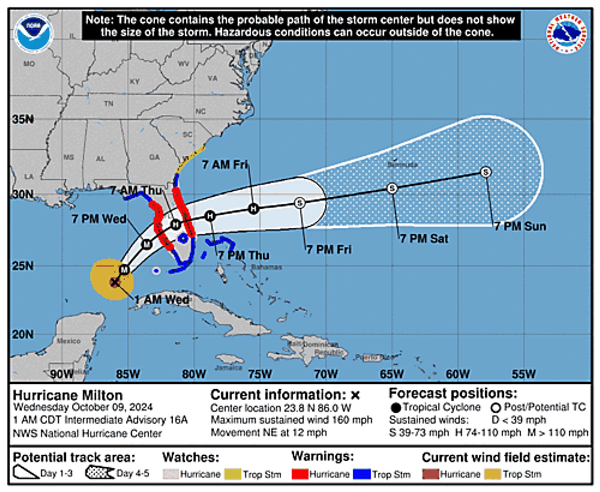
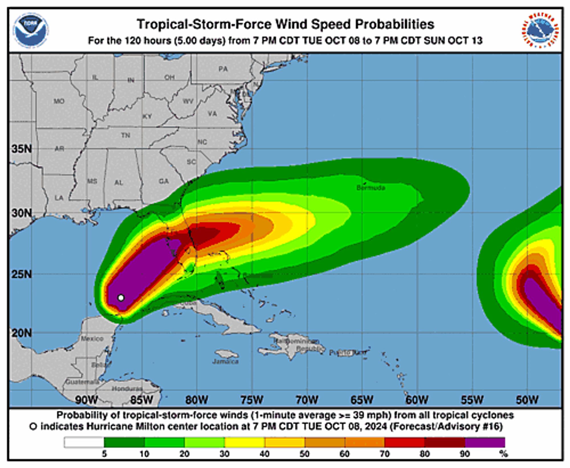
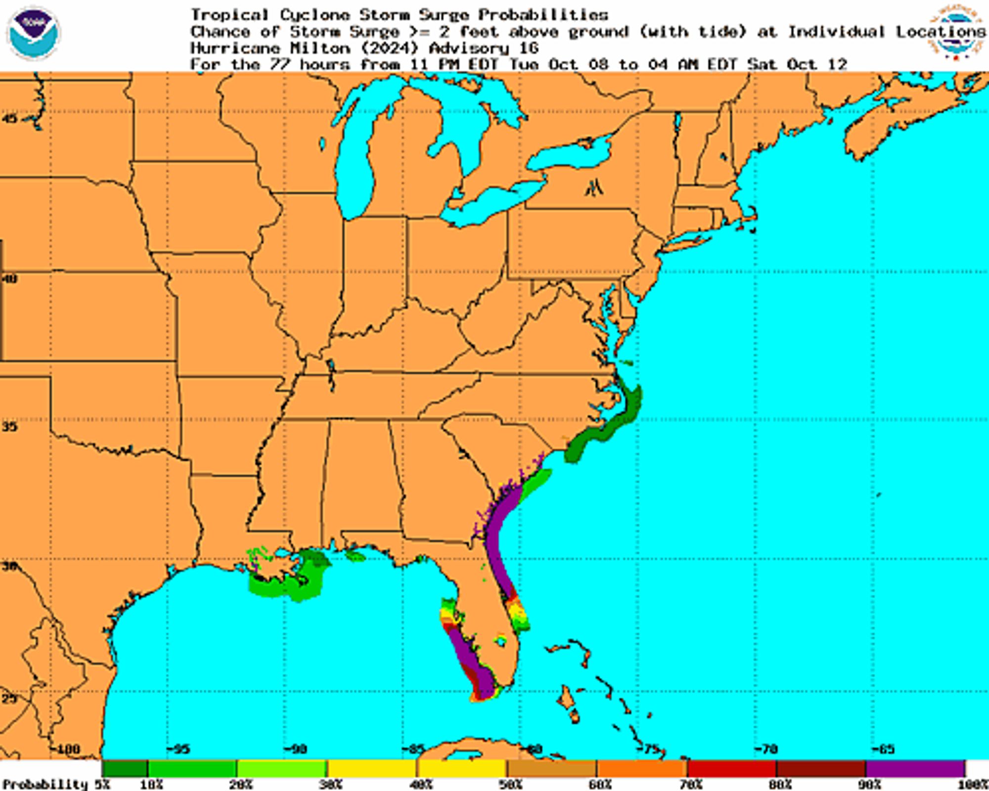
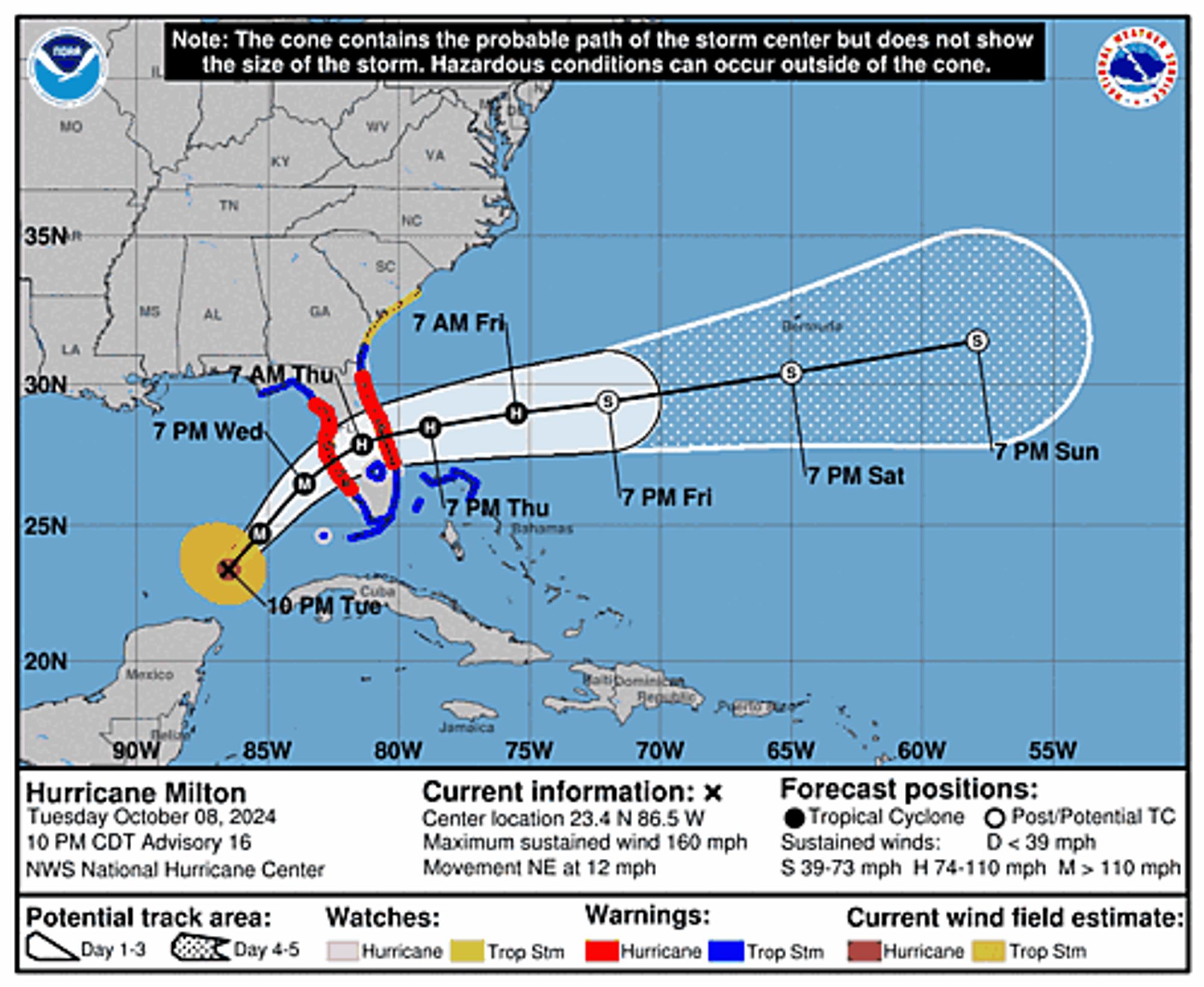
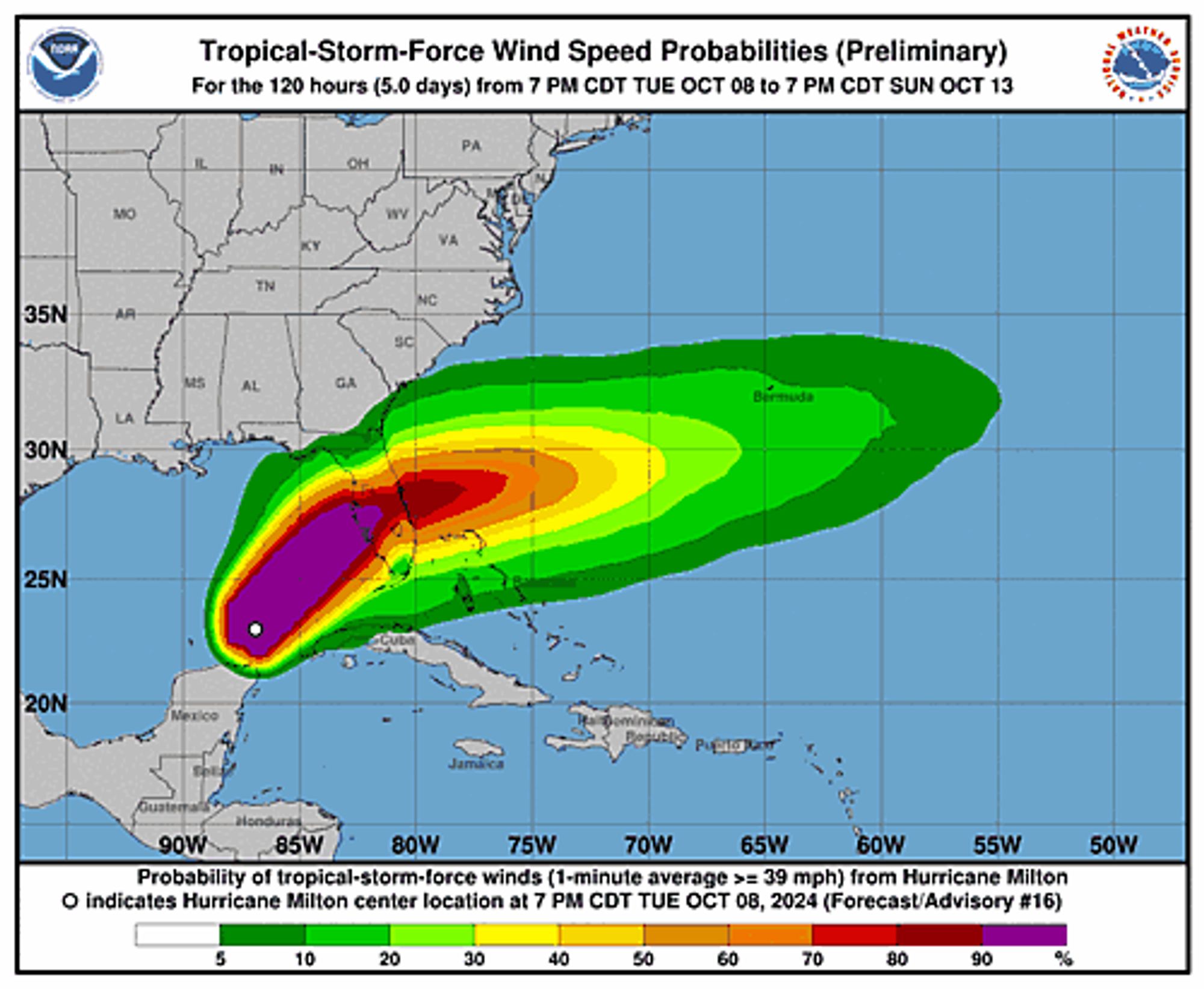
Atlantic Hurricane Milton Advisory Number 16 issued at Wed, 09 Oct 2024 02:41:51 +0000 ...MILTON EXPECTED TO MAKE LANDFALL ON THE GULF COAST OF FLORIDA LATE WEDNESDAY AS A DANGEROUS MAJOR HURRICANE... Additional Details Here.


 <br />
 000<br />
 WTNT34 KNHC 090241<br />
 TCPAT4<br />
  <br />
 BULLETIN<br />
 Hurricane Milton Advisory Number  16<br />
 NWS National Hurricane Center Miami FL       AL142024<br />
 1000 PM CDT Tue Oct 08 2024<br />
  <br />
 ...MILTON EXPECTED TO MAKE LANDFALL ON THE GULF COAST OF FLORIDA<br />
 LATE WEDNESDAY AS A DANGEROUS MAJOR HURRICANE...<br />
  <br />
  <br />
 SUMMARY OF 1000 PM CDT...0300 UTC...INFORMATION<br />
 -----------------------------------------------<br />
 LOCATION...23.4N 86.5W<br />
 ABOUT 245 MI...395 KM WSW OF THE DRY TORTUGAS<br />
 ABOUT 405 MI...650 KM SW OF TAMPA FLORIDA<br />
 MAXIMUM SUSTAINED WINDS...160 MPH...260 KM/H<br />
 PRESENT MOVEMENT...NE OR 55 DEGREES AT 12 MPH...19 KM/H<br />
 MINIMUM CENTRAL PRESSURE...915 MB...27.02 INCHES<br />
  <br />
  <br />
 WATCHES AND WARNINGS<br />
 --------------------<br />
 CHANGES WITH THIS ADVISORY:<br />
  <br />
 The government of Mexico has discontinued the Tropical Storm<br />
 Warning for the Yucatan Peninsula from Dzilam to Cancun.<br />
  <br />
 SUMMARY OF WATCHES AND WARNINGS IN EFFECT:<br />
  <br />
 A Storm Surge Warning is in effect for...<br />
 * Florida west coast from Flamingo northward to Suwannee River,<br />
 including Charlotte Harbor and Tampa Bay<br />
 * Sebastian Inlet Florida to Altamaha Sound Georgia, including the<br />
 St. Johns River<br />
  <br />
 A Hurricane Warning is in effect for...<br />
 * Florida west coast from Bonita Beach northward to Suwannee River,<br />
 including Tampa Bay<br />
 * Florida east coast from the St. Lucie/Martin County Line northward<br />
 to Ponte Vedra Beach<br />
  <br />
 A Storm Surge Watch is in effect for...<br />
 * North of Altamaha Sound Georgia to Edisto Beach South Carolina<br />
  <br />
 A Hurricane Watch is in effect for...<br />
 * Dry Tortugas<br />
 * Lake Okeechobee<br />
 * Florida west coast from Chokoloskee to south of Bonita Beach<br />
 * Florida east coast north of Ponte Vedra Beach to the mouth of the<br />
 St. Marys River<br />
 * Florida east coast from the St. Lucie/Martin County Line to the<br />
 Palm Beach/Martin County Line<br />
  <br />
 A Tropical Storm Warning is in effect for...<br />
 * Florida Keys, including Dry Tortugas and Florida Bay<br />
 * Lake Okeechobee<br />
 * Florida west coast from Flamingo to south of Bonita Beach<br />
 * Florida west coast from north of Suwanee River to Indian Pass<br />
 * Florida east coast south of the St. Lucie/Martin County Line to<br />
 Flamingo<br />
 * North of Ponte Vedra Beach Florida to Altamaha Sound Georgia<br />
 * Extreme northwestern Bahamas, including Grand Bahama Island, the<br />
 Abacos, and Bimini<br />
  <br />
 A Tropical Storm Watch is in effect for...<br />
 * North of Altamaha Sound Georgia to South Santee River South<br />
 Carolina<br />
  <br />
 A Storm Surge Warning means there is a danger of life-threatening<br />
 inundation, from rising water moving inland from the coastline,<br />
 during the next 36 hours in the indicated locations. For a<br />
 depiction of areas at risk, please see the National Weather<br />
 Service Storm Surge Watch/Warning Graphic, available at<br />
 hurricanes.gov.  This is a life-threatening situation.  Persons<br />
 located within these areas should take all necessary actions to<br />
 protect life and property from rising water and the potential for<br />
 other dangerous conditions.  Promptly follow evacuation and other<br />
 instructions from local officials.<br />
  <br />
 A Hurricane Warning means that hurricane conditions are expected<br />
 somewhere within the warning area.  A warning is typically issued<br />
 36 hours before the anticipated first occurrence of<br />
 tropical-storm-force winds, conditions that make outside<br />
 preparations difficult or dangerous.  Preparations to protect life<br />
 and property should be rushed to completion.<br />
  <br />
 A Tropical Storm Warning means that tropical storm conditions are<br />
 expected somewhere within the warning area within 36 hours.<br />
  <br />
 A Storm Surge Watch means there is a possibility of life-<br />
 threatening inundation, from rising water moving inland from the<br />
 coastline, in the indicated locations during the next 48 hours.<br />
 For a depiction of areas at risk, please see the National Weather<br />
 Service Storm Surge Watch/Warning Graphic, available at<br />
 hurricanes.gov.<br />
  <br />
 A Hurricane Watch means that hurricane conditions are possible<br />
 within the watch area.  A watch is typically issued 48 hours<br />
 before the anticipated first occurrence of tropical-storm-force<br />
 winds, conditions that make outside preparations difficult or<br />
 dangerous.<br />
  <br />
 A Tropical Storm Watch means that tropical storm conditions are<br />
 possible within the watch area, generally within 48 hours.<br />
  <br />
 For storm information specific to your area in the United<br />
 States, including possible inland watches and warnings, please<br />
 monitor products issued by your local National Weather Service<br />
 forecast office. For storm information specific to your area<br />
 outside of the United States, please monitor products issued by<br />
 your national meteorological service.<br />
  <br />
  <br />
 DISCUSSION AND OUTLOOK<br />
 ----------------------<br />
 At 1000 PM CDT (0300 UTC), the eye of Hurricane Milton was<br />
 located near latitude 23.4 North, longitude 86.5 West.  Milton is<br />
 moving toward the northeast near 12 mph (19 km/h).  A northeastward<br />
 motion with some increase in forward speed is expected overnight<br />
 through Wednesday.  A turn toward the east-northeast and east is<br />
 expected on Thursday and Friday.  On the forecast track, the center<br />
 of Milton will move across the eastern Gulf of Mexico tonight and<br />
 Wednesday, make landfall along the west-central coast of Florida<br />
 Wednesday night, and move off the east coast of Florida over the<br />
 Atlantic Ocean on Thursday.<br />
  <br />
 Maximum sustained winds are near 160 mph (260 km/h) with higher<br />
 gusts.  Milton is a category 5 hurricane on the Saffir-Simpson<br />
 Hurricane Wind Scale.  Fluctuations in intensity are likely while<br />
 Milton moves across the eastern Gulf of Mexico, but Milton is<br />
 expected to be a dangerous major hurricane when it reaches the<br />
 west-central coast of Florida Wednesday night.<br />
  <br />
 Hurricane-force winds extend outward up to 30 miles (45 km) from the<br />
 center and tropical-storm-force winds extend outward up to 140 miles<br />
 (220 km).<br />
  <br />
 The minimum central pressure estimated from Hurricane Hunter <br />
 aircraft observations is 915 mb (27.02 inches).<br />
  <br />
  <br />
 HAZARDS AFFECTING LAND<br />
 ----------------------<br />
 Key Messages for Milton can be found in the Tropical Cyclone<br />
 Discussion under AWIPS header MIATCDAT4 and WMO header WTNT44 KNHC<br />
 and on the web at hurricanes.gov/text/MIATCDAT4.shtml<br />
  <br />
 STORM SURGE: The combination of a dangerous storm surge and the <br />
 tide will cause normally dry areas near the coast to be flooded by <br />
 rising waters moving inland from the shoreline.  The water could <br />
 reach the following heights above ground somewhere in the indicated <br />
 areas if the peak surge occurs at the time of high tide...<br />
  <br />
 Egmont Key, FL to Boca Grande, FL...10-15 ft<br />
 Tampa Bay...10-15 ft<br />
 Anclote River, FL to Egmont Key, FL...9-13 ft<br />
 Boca Grande, FL to Bonita Beach, FL...8-12 ft<br />
 Charlotte Harbor...8-12 ft<br />
 Bonita Beach, FL to Chokoloskee, FL...5-8 ft<br />
 Aripeka, FL to Anclote River, FL...5-8 ft<br />
 Chokoloskee, FL to Flamingo, FL...3-5 ft<br />
 Sebastian Inlet, FL to Altamaha Sound, GA...3-5 ft<br />
 Altamaha Sound, GA to Edisto Beach, SC...2-4 ft<br />
 Suwannee River, FL to Aripeka, FL...2-4 ft<br />
 Dry Tortugas...2-4 ft<br />
 St. Johns River...2-4 ft<br />
 <br />
 The deepest water will occur along the immediate coast near and to<br />
 the south of the landfall location, where the surge will be<br />
 accompanied by large and dangerous waves.  Surge-related flooding<br />
 depends on the relative timing of the surge and the tidal cycle,<br />
 and can vary greatly over short distances.  For information<br />
 specific to your area, please see products issued by your local<br />
 National Weather Service forecast office.<br />
  <br />
 For a complete depiction of areas at risk of storm surge<br />
 inundation, please see the National Weather Service Peak Storm<br />
 Surge Graphic, available at<br />
 hurricanes.gov/graphics_at4.shtml?peakSurge.<br />
  <br />
 RAINFALL: Rainfall amounts of 6 to 12 inches, with localized totals<br />
 up to 18 inches, are expected across central to northern portions of<br />
 the Florida Peninsula through Thursday.  This rainfall brings the<br />
 risk of catastrophic and life-threatening flash and urban flooding,<br />
 along with moderate to major river flooding.<br />
  <br />
 Additional rainfall amounts of  2 to 4 inches, with isolated totals<br />
 around 6 inches, are expected across northern portions of the<br />
 Yucatan Peninsula.<br />
  <br />
 For a complete depiction of forecast rainfall associated with<br />
 Hurricane Milton, please see the National Weather Service Storm<br />
 Total Rainfall Graphic, available at<br />
 hurricanes.gov/graphics_at4.shtml?rainqpf and the Flash Flood Risk<br />
 graphic at hurricanes.gov/graphics_at4.shtml?ero.<br />
  <br />
 WIND: Hurricane conditions are expected in the hurricane warning<br />
 area across Florida beginning late Wednesday through early Thursday<br />
 and are possible in the hurricane watch area on Thursday. Tropical<br />
 storm conditions are expected to begin in the warning area on the<br />
 west coast of Florida around midday Wednesday, spreading across the<br />
 peninsula and reaching the east coast Wednesday evening. Tropical<br />
 storm conditions are expected to begin in the warning area on the<br />
 east coast of Florida late Wednesday.<br />
  <br />
 Tropical storm conditions are expected in portions of the <br />
 northwestern Bahamas on Thursday.<br />
  <br />
 Tropical storm conditions are possible within the watch area<br />
 on the Georgia and South Carolina coasts on Thursday.<br />
  <br />
 TORNADOES: A few tornadoes are possible over central and southern<br />
 Florida through Thursday night.<br />
  <br />
 SURF:  Swells generated by Milton are expected to continue to<br />
 affect much of the Gulf Coast during the next day or two, and are<br />
 likely to cause life-threatening surf and rip current conditions.<br />
 Please consult products from your local weather office.<br />
  <br />
  <br />
 NEXT ADVISORY<br />
 -------------<br />
 Next intermediate advisory at 100 AM CDT.<br />
 Next complete advisory at 400 AM CDT.<br />
  <br />
 $$<br />
 Forecaster Pasch<br />
  <br />
Hurricane Milton 5-Day Uncertainty Track Image
Hurricane Milton 34-Knot Wind Speed Probabilities
Hurricane Milton Probabilistic Storm Surge Graphics Image
0
NHnhc-atlc.nws-bot.us

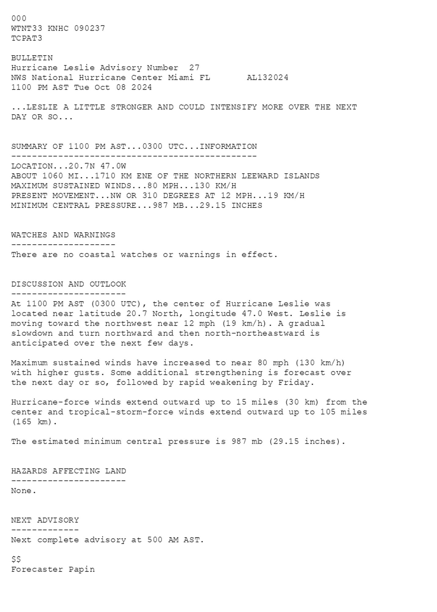
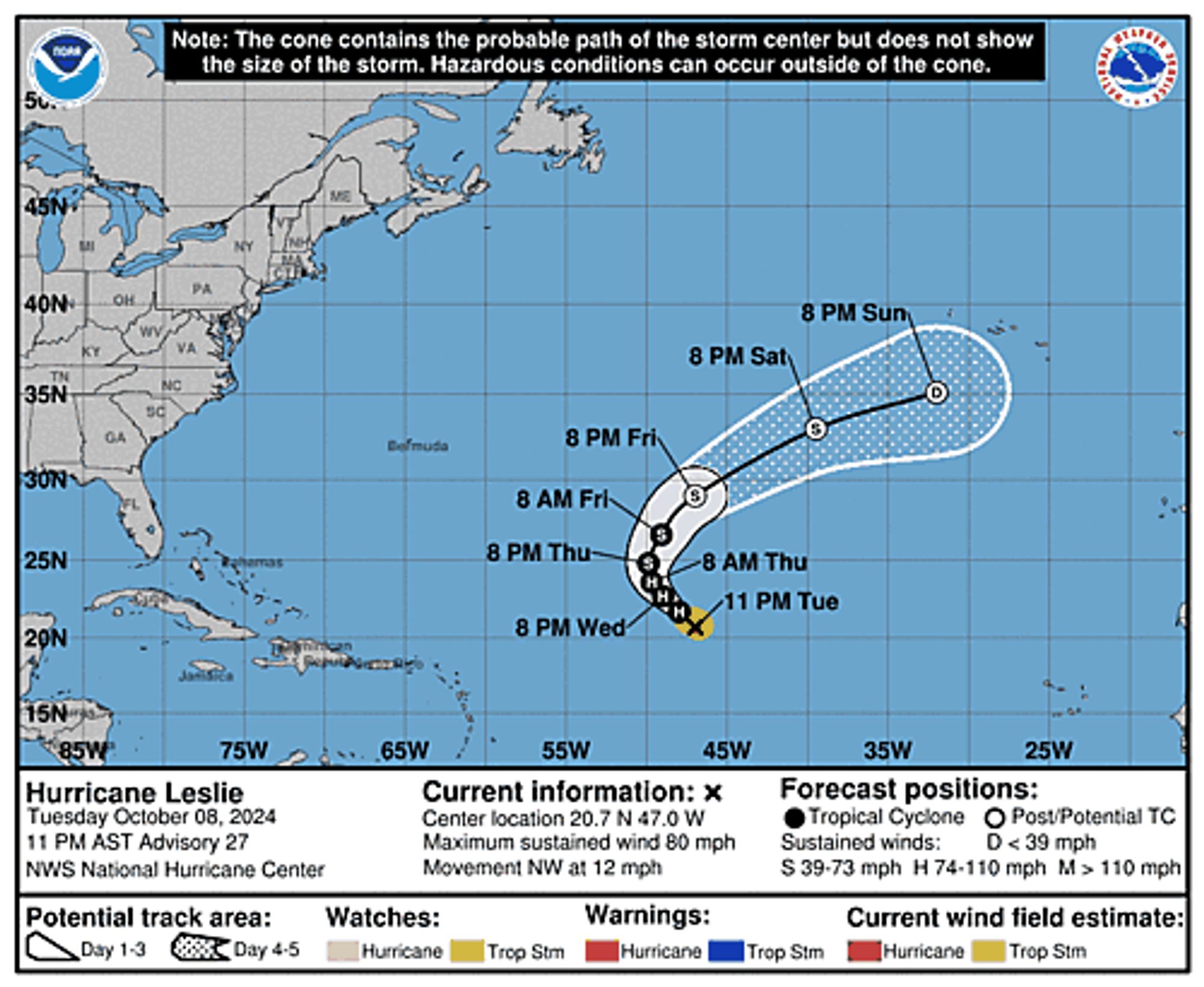
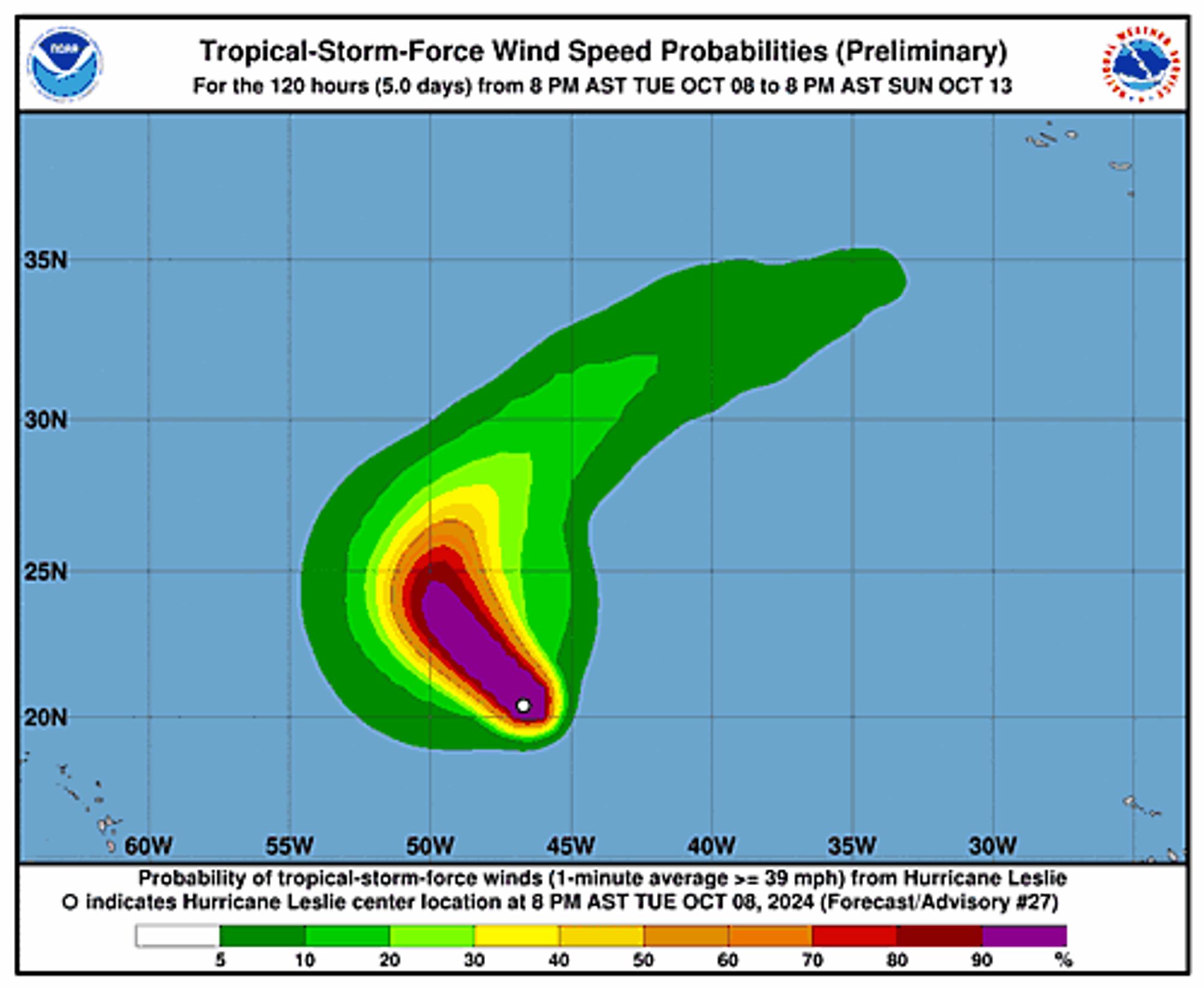
Atlantic Hurricane Leslie Advisory Number 27 issued at Wed, 09 Oct 2024 02:37:52 +0000 ...LESLIE A LITTLE STRONGER AND COULD INTENSIFY MORE OVER THE NEXT DAY OR SO... Additional Details Here.


 <br />
 000<br />
 WTNT33 KNHC 090237<br />
 TCPAT3<br />
  <br />
 BULLETIN<br />
 Hurricane Leslie Advisory Number  27<br />
 NWS National Hurricane Center Miami FL       AL132024<br />
 1100 PM AST Tue Oct 08 2024<br />
  <br />
 ...LESLIE A LITTLE STRONGER AND COULD INTENSIFY MORE OVER THE NEXT <br />
 DAY OR SO...<br />
  <br />
  <br />
 SUMMARY OF 1100 PM AST...0300 UTC...INFORMATION<br />
 -----------------------------------------------<br />
 LOCATION...20.7N 47.0W<br />
 ABOUT 1060 MI...1710 KM ENE OF THE NORTHERN LEEWARD ISLANDS<br />
 MAXIMUM SUSTAINED WINDS...80 MPH...130 KM/H<br />
 PRESENT MOVEMENT...NW OR 310 DEGREES AT 12 MPH...19 KM/H<br />
 MINIMUM CENTRAL PRESSURE...987 MB...29.15 INCHES<br />
  <br />
  <br />
 WATCHES AND WARNINGS<br />
 --------------------<br />
 There are no coastal watches or warnings in effect.<br />
  <br />
  <br />
 DISCUSSION AND OUTLOOK<br />
 ----------------------<br />
 At 1100 PM AST (0300 UTC), the center of Hurricane Leslie was<br />
 located near latitude 20.7 North, longitude 47.0 West. Leslie is<br />
 moving toward the northwest near 12 mph (19 km/h). A gradual <br />
 slowdown and turn northward and then north-northeastward is <br />
 anticipated over the next few days. <br />
  <br />
 Maximum sustained winds have increased to near 80 mph (130 km/h) <br />
 with higher gusts. Some additional strengthening is forecast over <br />
 the next day or so, followed by rapid weakening by Friday. <br />
 <br />
 Hurricane-force winds extend outward up to 15 miles (30 km) from the<br />
 center and tropical-storm-force winds extend outward up to 105 miles<br />
 (165 km).<br />
  <br />
 The estimated minimum central pressure is 987 mb (29.15 inches).<br />
  <br />
  <br />
 HAZARDS AFFECTING LAND<br />
 ----------------------<br />
 None.<br />
  <br />
  <br />
 NEXT ADVISORY<br />
 -------------<br />
 Next complete advisory at 500 AM AST.<br />
  <br />
 $$<br />
 Forecaster Papin<br />
  <br />
Hurricane Leslie 5-Day Uncertainty Track Image
Hurricane Leslie 34-Knot Wind Speed Probabilities
0
ASashleyshoo.bsky.social

As part of scary season, I'll be sharing information about the evils and hazards of stairs. Did you know that in the United States ~12,000 people die by falling down stairs each year? #Falloween#DisabilityStatus

0
AFmhx.nws-bot.us

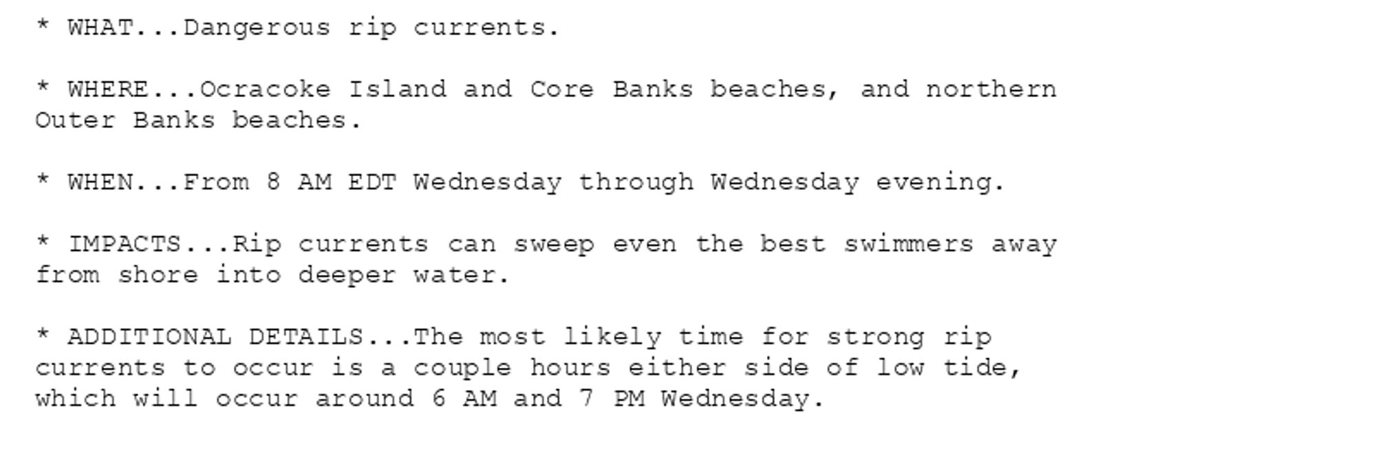
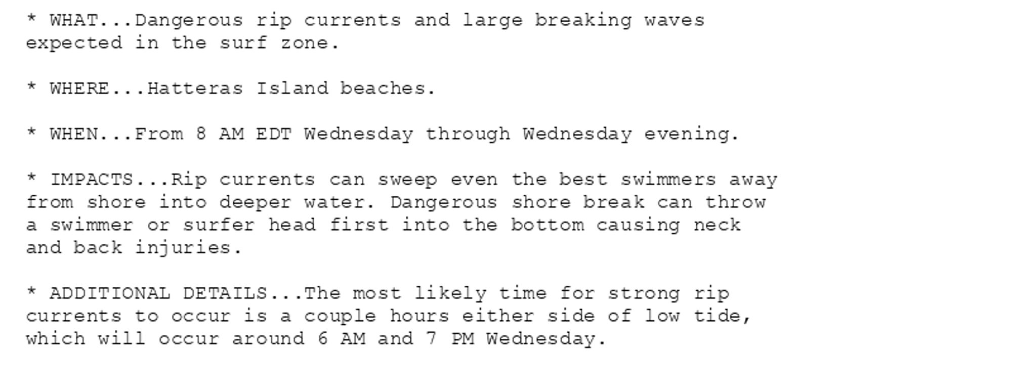
Beach Hazards Statement issued October 8 at 8:18PM EDT until October 9 at 8:00PM EDT by NWS Newport/Morehead City NC Additional Details Here.

* WHAT...Dangerous rip currents.

* WHERE...Ocracoke Island and Core Banks beaches, and northern
Outer Banks beaches.

* WHEN...From 8 AM EDT Wednesday through Wednesday evening.

* IMPACTS...Rip currents can sweep even the best swimmers away
from shore into deeper water.

* ADDITIONAL DETAILS...The most likely time for strong rip
currents to occur is a couple hours either side of low tide,
which will occur around 6 AM and 7 PM Wednesday.
* WHAT...Dangerous rip currents and large breaking waves
expected in the surf zone.

* WHERE...Hatteras Island beaches.

* WHEN...From 8 AM EDT Wednesday through Wednesday evening.

* IMPACTS...Rip currents can sweep even the best swimmers away
from shore into deeper water. Dangerous shore break can throw
a swimmer or surfer head first into the bottom causing neck
and back injuries.

* ADDITIONAL DETAILS...The most likely time for strong rip
currents to occur is a couple hours either side of low tide,
which will occur around 6 AM and 7 PM Wednesday.
0