BLUE
TLlaranaoclara.bsky.social

lembrando quando conheci uma gringa da holanda e perguntei se ela sabia quem era mauricio de nassau e basicamente ele é um fracassado msm pois só ficou famoso aqui

0
Ttbapple.bsky.social

She came from Nassau County PD. Probably why she was pushed out or maybe she dropped a dime on the lot of them on the way out the door.

0
brooklynkid52.bsky.social

I don't think I have ever seen this in my lifetime, although the many investigations of police misconduct (Serpico, etc) are as bad as this if not worse IIRC, in the 1980s, in *GOP* run Nassau county there was a policy, perhaps written, that county employees had to kick back 2% of salary to bosses

0
AFjax.nws-bot.us

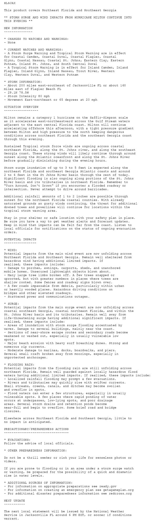
Tropical Cyclone Statement issued October 10 at 2:11PM EDT by NWS Jacksonville FL Additional Details Here.

HLSJAX

This product covers Northeast Florida and Southeast Georgia

** MILTON BECOMES AN EXTRATROPICAL LOW PRESSURE CENTER**

NEW INFORMATION
---------------

* CHANGES TO WATCHES AND WARNINGS:
- The Tropical Storm Warning has been cancelled for Inland
Camden, Inland Glynn, Inland Nassau, Western Clay, Western
Duval, and Western Putnam

* CURRENT WATCHES AND WARNINGS:
- A Storm Surge Warning and Tropical Storm Warning are in effect
for Coastal Camden, Coastal Duval, Coastal Flagler, Coastal
Glynn, Coastal Nassau, Coastal St. Johns, Eastern Clay, Eastern
Putnam, Inland St. Johns, and South Central Duval
- A Tropical Storm Warning is in effect for Inland Flagler and
Trout River

* STORM INFORMATION:
- About 250 miles east-southeast of Jacksonville FL or about 220
miles east of Flagler Beach FL
- 29.3N 77.5W
- Storm Intensity 75 mph
- Movement East-northeast or 70 degrees at 21 mph

SITUATION OVERVIEW
------------------

Milton has transitioned to an extratropical low pressure center that
still contains hurricane force winds as it accelerates
east-northeastward across the open waters of the western Atlantic
Ocean. A tight pressure gradient between extratropical Milton and
high pressure to the north will keep dangerous conditions across
coastal northeast Florida and southeast Georgia through this evening,
especially with the afternoon and evening high tide cycle all along
the Atlantic coast and within the St. Johns River basin and its
tributaries.

Occasional tropical Storm force gusts are ongoing across coastal
northeast Florida, along the St. Johns river, and along the southeast
Georgia coast. These gusts will likely continue through around
sunset this evening before gradually diminishing during the evening
hours.

Storm surge inundation of up to 3 to 5 feet is expected along the
northeast Florida and southeast Georgia Atlantic coasts and around
2 to 4 feet in the St Johns River basin through the rest of today.
Significant flooding is also ongoing along portions of the St. Johns
River basin and its tributaries in northeast Florida. Remember to
"Turn Around, Don't Drown" if you encounter a flooded roadway or
intersection. Never attempt to drive around barricades.

Additional rainfall amounts of up to one half inch are possible through
sunset for the northeast Florida coastal counties. With already
saturated grounds an gusty winds continuing, the threat for additional
downed trees and powerlines will continue for locations within the
tropical storm warning area.

Stay in your shelter or safe location with your safety plan in place.
Be sure you have a way to get weather alerts and forecast updates.
Keep in mind that impacts can be felt far from the coast. Listen to
local officials for notifications on the status of ongoing evacuation
orders.

POTENTIAL IMPACTS
-----------------

* WIND:
Potential impacts from the main wind event are now unfolding across
Northeast Florida and Southeast Georgia. Remain well sheltered from
hazardous wind having additional limited impacts. If realized, these
impacts include:
- Damage to porches, awnings, carports, sheds, and unanchored
mobile homes. Unsecured lightweight objects blown about.
- Many large tree limbs broken off. A few trees snapped or
uprooted, but with greater numbers in places where trees are
shallow rooted. Some fences and roadway signs blown over.
- A few roads impassable from debris, particularly within urban
or heavily wooded places. Hazardous driving conditions on
bridges and other elevated roadways.
- Scattered power and communications outages.

* SURGE:
Potential impacts from the main surge event are now unfolding across
coastal southeast Georgia, coastal northeast Florida, and within the
St. Johns River basin and its tributaries. Remain well away from
life-threatening surge having additional significant impacts. If
realized, these impacts include:
- Areas of inundation with storm surge flooding accentuated by
waves. Damage to several buildings, mainly near the coast.
- Sections of near-shore escape routes and secondary roads become
weakened or washed out, especially in usually vulnerable low
spots.
- Major beach erosion with heavy surf breaching dunes. Strong and
numerous rip currents.
- Moderate damage to marinas, docks, boardwalks, and piers.
Several small craft broken away from moorings, especially in
unprotected anchorages.

* FLOODING RAIN:
Potential impacts from the flooding rain are still unfolding across
northeast Florida. Remain well guarded against locally hazardous
flood waters having additional limited impacts. If realized, these
impacts include:
- Localized rainfall flooding may prompt a few evacuations.
- Rivers and tributaries may quickly rise with swifter currents.
Small streams, creeks, canals, and ditches may become swollen
and overflow in spots.
- Flood waters can enter a few structures, especially in usually
vulnerable spots. A few places where rapid ponding of water
occurs at underpasses, low-lying spots, and poor drainage
areas. Several storm drains and retention ponds become
near-full and begin to overflow. Some brief road and bridge
closures.

Elsewhere across Northeast Florida and Southeast Georgia, little to
no impact is anticipated.

PRECAUTIONARY/PREPAREDNESS ACTIONS
----------------------------------

* EVACUATIONS:
Follow the advice of local officials.

* OTHER PREPAREDNESS INFORMATION:
Do not be a thrill seeker or risk your life for senseless photos or
videos.

If you are prone to flooding or in an area under a storm surge watch
or warning, be prepared for the possibility of a quick and dramatic
rise in water levels.

* ADDITIONAL SOURCES OF INFORMATION:
- For information on appropriate preparations see ready.gov
- For information on creating an emergency plan see getagameplan.org
- For additional disaster preparedness information see redcross.org

NEXT UPDATE
-----------

The next local statement will be issued by the National Weather
Service in Jacksonville FL around 6 PM, or sooner if conditions
warrant.
0
AFjax.nws-bot.us

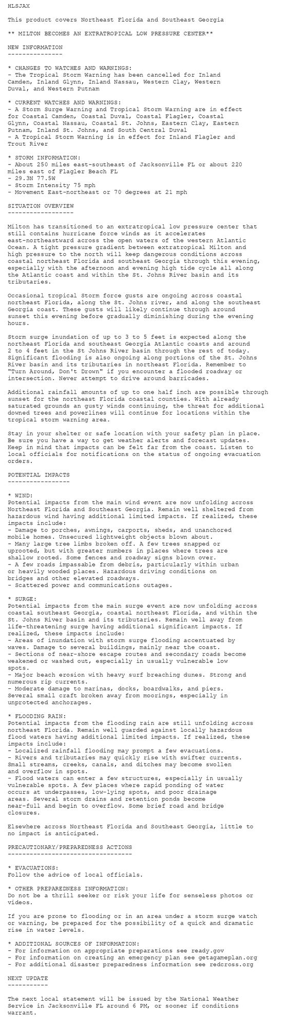
Tropical Cyclone Statement issued October 10 at 11:04AM EDT by NWS Jacksonville FL Additional Details Here.

HLSJAX

This product covers Northeast Florida and Southeast Georgia

** STORM SURGE AND WIND IMPACTS FROM HURRICANE MILTON CONTINUE INTO
THIS EVENING **

NEW INFORMATION
---------------

* CHANGES TO WATCHES AND WARNINGS:
- None

* CURRENT WATCHES AND WARNINGS:
- A Storm Surge Warning and Tropical Storm Warning are in effect
for Coastal Camden, Coastal Duval, Coastal Flagler, Coastal
Glynn, Coastal Nassau, Coastal St. Johns, Eastern Clay, Eastern
Putnam, Inland St. Johns, and South Central Duval
- A Tropical Storm Warning is in effect for Inland Camden, Inland
Flagler, Inland Glynn, Inland Nassau, Trout River, Western
Clay, Western Duval, and Western Putnam

* STORM INFORMATION:
- About 200 miles east-southeast of Jacksonville FL or about 160
miles east of Flagler Beach FL
- 29.1N 78.5W
- Storm Intensity 80 mph
- Movement East-northeast or 65 degrees at 20 mph

SITUATION OVERVIEW
------------------

Milton remains a category 1 hurricane on the Saffir-Simpson scale
as it accelerates east-northeastward across the Gulf Stream waters
adjacent to the east central Florida coast. Milton will continue
accelerating offshore this afternoon, with a tight pressure gradient
between Milton and high pressure to the north keeping dangerous
conditions across northeast Florida and the southeast Georgia coast
through this evening.

Sustained Tropical storm force winds are ongoing across coastal
northeast Florida, along the St. Johns river, and along the southeast
Georgia coast. These strong winds will likely continue through around
sunset along the Atlantic oceanfront and along the St. Johns River
before gradually diminishing during the evening hours.

Storm surge inundation of up to 3 to 5 feet is expected along the
northeast Florida and southeast Georgia Atlantic coasts and around
2 to 4 feet in the St Johns River basin through the rest of today.
Significant flooding is also ongoing along portions of the St. Johns
River basin and its tributaries in northeast Florida. Remember to
"Turn Around, Don't Drown" if you encounter a flooded roadway or
intersection. Never attempt to drive around barricades.

Additional rainfall amounts of 1 to 2 inches are possible through
sunset for the northeast Florida coastal counties. With already
saturated grounds an gusty winds continuing, the threat for additional
downed trees and powerlines will continue for locations within the
tropical storm warning area.

Stay in your shelter or safe location with your safety plan in place.
Be sure you have a way to get weather alerts and forecast updates.
Keep in mind that impacts can be felt far from the coast. Listen to
local officials for notifications on the status of ongoing evacuation
orders.

POTENTIAL IMPACTS
-----------------

* WIND:
Potential impacts from the main wind event are now unfolding across
Northeast Florida and Southeast Georgia. Remain well sheltered from
hazardous wind having additional limited impacts. If
realized, these impacts include:
- Damage to porches, awnings, carports, sheds, and unanchored
mobile homes. Unsecured lightweight objects blown about.
- Many large tree limbs broken off. A few trees snapped or
uprooted, but with greater numbers in places where trees are
shallow rooted. Some fences and roadway signs blown over.
- A few roads impassable from debris, particularly within urban
or heavily wooded places. Hazardous driving conditions on
bridges and other elevated roadways.
- Scattered power and communications outages.

* SURGE:
Potential impacts from the main surge event are now unfolding across
coastal southeast Georgia, coastal northeast Florida, and within the
St. Johns River basin and its tributaries. Remain well away from
life-threatening surge having additional significant impacts. If
realized, these impacts include:
- Areas of inundation with storm surge flooding accentuated by
waves. Damage to several buildings, mainly near the coast.
- Sections of near-shore escape routes and secondary roads become
weakened or washed out, especially in usually vulnerable low
spots.
- Major beach erosion with heavy surf breaching dunes. Strong and
numerous rip currents.
- Moderate damage to marinas, docks, boardwalks, and piers.
Several small craft broken away from moorings, especially in
unprotected anchorages.

* FLOODING RAIN:
Potential impacts from the flooding rain are still unfolding across
northeast Florida. Remain well guarded against locally hazardous flood
waters having additional limited impacts. If realized, these impacts include:
- Localized rainfall flooding may prompt a few evacuations.
- Rivers and tributaries may quickly rise with swifter currents.
Small streams, creeks, canals, and ditches may become swollen
and overflow in spots.
- Flood waters can enter a few structures, especially in usually
vulnerable spots. A few places where rapid ponding of water
occurs at underpasses, low-lying spots, and poor drainage
areas. Several storm drains and retention ponds become
near-full and begin to overflow. Some brief road and bridge
closures.

Elsewhere across Northeast Florida and Southeast Georgia, little to
no impact is anticipated.

PRECAUTIONARY/PREPAREDNESS ACTIONS
----------------------------------

* EVACUATIONS:
Follow the advice of local officials.

* OTHER PREPAREDNESS INFORMATION:

Do not be a thrill seeker or risk your life for senseless photos or
videos.

If you are prone to flooding or in an area under a storm surge watch
or warning, be prepared for the possibility of a quick and dramatic
rise in water levels.

* ADDITIONAL SOURCES OF INFORMATION:
- For information on appropriate preparations see ready.gov
- For information on creating an emergency plan see getagameplan.org
- For additional disaster preparedness information see redcross.org

NEXT UPDATE
-----------

The next local statement will be issued by the National Weather
Service in Jacksonville FL around 6 PM EDT, or sooner if conditions
warrant.
0
RCrussellcohn.bsky.social

Wanting to build a casino in Nassau over Flushing-Willets Points is so fucking dumb

0
EEerice549.bsky.social

reminder: new york state is every rightoid's hell. no matter how conservative your locale is… whether upstate, nassau/suffolk, or even staten island… you will always be drowned out by the city. you will always be drowned out by us.

0
AFjax.nws-bot.us

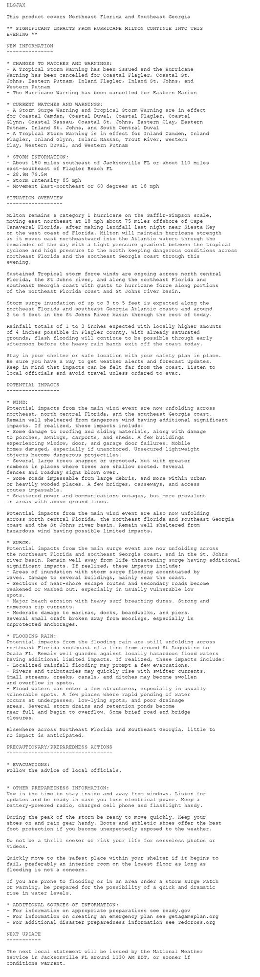
Tropical Cyclone Statement issued October 10 at 8:12AM EDT by NWS Jacksonville FL Additional Details Here.

HLSJAX

This product covers Northeast Florida and Southeast Georgia

** SIGNIFICANT IMPACTS FROM HURRICANE MILTON CONTINUE INTO THIS
EVENING **

NEW INFORMATION
---------------

* CHANGES TO WATCHES AND WARNINGS:
- A Tropical Storm Warning has been issued and the Hurricane
Warning has been cancelled for Coastal Flagler, Coastal St.
Johns, Eastern Putnam, Inland Flagler, Inland St. Johns, and
Western Putnam
- The Hurricane Warning has been cancelled for Eastern Marion

* CURRENT WATCHES AND WARNINGS:
- A Storm Surge Warning and Tropical Storm Warning are in effect
for Coastal Camden, Coastal Duval, Coastal Flagler, Coastal
Glynn, Coastal Nassau, Coastal St. Johns, Eastern Clay, Eastern
Putnam, Inland St. Johns, and South Central Duval
- A Tropical Storm Warning is in effect for Inland Camden, Inland
Flagler, Inland Glynn, Inland Nassau, Trout River, Western
Clay, Western Duval, and Western Putnam

* STORM INFORMATION:
- About 150 miles southeast of Jacksonville FL or about 110 miles
east-southeast of Flagler Beach FL
- 28.9N 79.5W
- Storm Intensity 85 mph
- Movement East-northeast or 60 degrees at 18 mph

SITUATION OVERVIEW
------------------

Milton remains a category 1 hurricane on the Saffir-Simpson scale,
moving east northeast at 18 mph about 75 miles offshore of Cape
Canaveral Florida, after making landfall last night near Siesta Key
on the west coast of Florida. Milton will maintain hurricane strength
as it moves east northeastward into the Atlantic waters through the
remainder of the day with a tight pressure gradient between the tropical
cyclone and high pressure to the north keeping dangerous conditions across
northeast Florida and the southeast Georgia coast through this
evening.

Sustained Tropical storm force winds are ongoing across north central
Florida, the St Johns river, and along the northeast Florida and
southeast Georgia coast with gusts to hurricane force along portions
of the northeast Florida coast and St Johns river basin.

Storm surge inundation of up to 3 to 5 feet is expected along the
northeast Florida and southeast Georgia Atlantic coasts and around
2 to 4 feet in the St Johns River basin through the rest of today.

Rainfall totals of 1 to 3 inches expected with locally higher amounts
of 4 inches possible in Flagler county. With already saturated
grounds, flash flooding will continue to be possible through early
afternoon before the heavy rain bands exit off the coast today.

Stay in your shelter or safe location with your safety plan in place.
Be sure you have a way to get weather alerts and forecast updates.
Keep in mind that impacts can be felt far from the coast. Listen to
local officials and avoid travel unless ordered to evac.

POTENTIAL IMPACTS
-----------------

* WIND:
Potential impacts from the main wind event are now unfolding across
northeast, north central Florida, and the southeast Georgia coast.
Remain well sheltered from dangerous wind having additional significant
impacts. If realized, these impacts include:
- Some damage to roofing and siding materials, along with damage
to porches, awnings, carports, and sheds. A few buildings
experiencing window, door, and garage door failures. Mobile
homes damaged, especially if unanchored. Unsecured lightweight
objects become dangerous projectiles.
- Several large trees snapped or uprooted, but with greater
numbers in places where trees are shallow rooted. Several
fences and roadway signs blown over.
- Some roads impassable from large debris, and more within urban
or heavily wooded places. A few bridges, causeways, and access
routes impassable.
- Scattered power and communications outages, but more prevalent
in areas with above ground lines.

Potential impacts from the main wind event are also now unfolding
across north central Florida, the northeast florida and southeast Georgia
coast and the St Johns river basin. Remain well sheltered from
hazardous wind having possible limited impacts.

* SURGE:
Potential impacts from the main surge event are now unfolding across
the northeast Florida and southeast Georgia coast, and in the St. Johns
river basin. Remain well away from life-threatening surge having additional
significant impacts. If realized, these impacts include:
- Areas of inundation with storm surge flooding accentuated by
waves. Damage to several buildings, mainly near the coast.
- Sections of near-shore escape routes and secondary roads become
weakened or washed out, especially in usually vulnerable low
spots.
- Major beach erosion with heavy surf breaching dunes. Strong and
numerous rip currents.
- Moderate damage to marinas, docks, boardwalks, and piers.
Several small craft broken away from moorings, especially in
unprotected anchorages.

* FLOODING RAIN:
Potential impacts from the flooding rain are still unfolding across
northeast Florida southeast of a line from around St Augustine to
Ocala FL. Remain well guarded against locally hazardous flood waters
having additional limited impacts. If realized, these impacts include:
- Localized rainfall flooding may prompt a few evacuations.
- Rivers and tributaries may quickly rise with swifter currents.
Small streams, creeks, canals, and ditches may become swollen
and overflow in spots.
- Flood waters can enter a few structures, especially in usually
vulnerable spots. A few places where rapid ponding of water
occurs at underpasses, low-lying spots, and poor drainage
areas. Several storm drains and retention ponds become
near-full and begin to overflow. Some brief road and bridge
closures.

Elsewhere across Northeast Florida and Southeast Georgia, little to
no impact is anticipated.

PRECAUTIONARY/PREPAREDNESS ACTIONS
----------------------------------

* EVACUATIONS:
Follow the advice of local officials.


* OTHER PREPAREDNESS INFORMATION:
Now is the time to stay inside and away from windows. Listen for
updates and be ready in case you lose electrical power. Keep a
battery-powered radio, charged cell phone and flashlight handy.

During the peak of the storm be ready to move quickly. Keep your
shoes on and rain gear handy. Boots and athletic shoes offer the best
foot protection if you become unexpectedly exposed to the weather.

Do not be a thrill seeker or risk your life for senseless photos or
videos.

Quickly move to the safest place within your shelter if it begins to
fail, preferably an interior room on the lowest floor as long as
flooding is not a concern.

If you are prone to flooding or in an area under a storm surge watch
or warning, be prepared for the possibility of a quick and dramatic
rise in water levels.

* ADDITIONAL SOURCES OF INFORMATION:
- For information on appropriate preparations see ready.gov
- For information on creating an emergency plan see getagameplan.org
- For additional disaster preparedness information see redcross.org

NEXT UPDATE
-----------

The next local statement will be issued by the National Weather
Service in Jacksonville FL around 1130 AM EDT, or sooner if
conditions warrant.
0
AFjax.nws-bot.us

Tropical Cyclone Statement issued October 10 at 5:09AM EDT by NWS Jacksonville FL Additional Details Here.

HLSJAX

This product covers Northeast Florida and Southeast Georgia

**SIGNIFICANT IMPACTS FROM HURRICANE MILTON CONTINUE INTO THIS
EVENING**

NEW INFORMATION
---------------

* CHANGES TO WATCHES AND WARNINGS:
- The Hurricane Warning has been cancelled for Central Marion and
Western Marion
- The Tropical Storm Warning has been cancelled for Baker,
Bradford, Eastern Alachua, Gilchrist, Northern Columbia,
Southeastern Columbia, Southwestern Columbia, Suwannee, Union,
and Western Alachua

* CURRENT WATCHES AND WARNINGS:
- A Storm Surge Warning and Hurricane Warning are in effect for
Coastal Flagler, Coastal St. Johns, Eastern Putnam, and Inland
St. Johns
- A Hurricane Warning is in effect for Eastern Marion, Inland
Flagler, and Western Putnam
- A Storm Surge Warning and Tropical Storm Warning are in effect
for Coastal Camden, Coastal Duval, Coastal Glynn, Coastal
Nassau, Eastern Clay, and South Central Duval
- A Tropical Storm Warning is in effect for Inland Camden, Inland
Glynn, Inland Nassau, Trout River, Western Clay, and Western
Duval

* STORM INFORMATION:
- About 140 miles south-southeast of Jacksonville FL or about 110
miles east-southeast of Ocala FL
- 28.5N 80.5W
- Storm Intensity 85 mph
- Movement Northeast or 55 degrees at 18 mph

SITUATION OVERVIEW
------------------

Milton remains a category 1 hurricane on the Saffir-Simpson scale,
moving east northeast at 18 mph near Cape Canaveral after making
landfall last night near Siesta Key on the west coast of Florida.
Milton will exit off the east central Florida coast near the Cape this
morning maintaining hurricane strength as it moves east or east
northeastward into the Atlantic waters through the remainder of the
day with a tight pressure gradient between the tropical cyclone and
high pressure to the north keeping dangerous conditions across
northeast Florida and the southeast Georgia coast through this
evening.

Sustained Tropical storm force winds are ongoing across north central
Florida, the St Johns river, and along the northeast Florida and
southeast Georgia coast with gusts to hurricane force along portions
of the northeast Florida coast and St Johns river basin.

Storm surge inundation of up to 3 to 5 feet is expected along the
northeast Florida and southeast Georgia Atlantic coasts and around
2 to 4 feet in the St Johns River basin through the rest of today.

Rainfall totals of 1 to 3 inches expected with locally higher amounts
of 4 inches possible in Flagler county. With already saturated grounds,
flash flooding will continue to be possible through early afternoon
before the heavy rain bands exit off the coast today.

Stay in your shelter or safe location with your safety plan in place.
Be sure you have a way to get weather alerts and forecast updates.
Keep in mind that impacts can be felt far from the coast. Listen to
local officials and avoid travel unless ordered to evacuate.

POTENTIAL IMPACTS
-----------------

* WIND:
Potential impacts from the main wind event are now unfolding across
northeast, north central Florida, and the southeast Georgia coast.
Remain well sheltered from dangerous wind having additional
significant impacts. If realized, these impacts include:
- Some damage to roofing and siding materials, along with damage
to porches, awnings, carports, and sheds. A few buildings
experiencing window, door, and garage door failures. Mobile
homes damaged, especially if unanchored. Unsecured lightweight
objects become dangerous projectiles.
- Several large trees snapped or uprooted, but with greater
numbers in places where trees are shallow rooted. Several
fences and roadway signs blown over.
- Some roads impassable from large debris, and more within urban
or heavily wooded places. A few bridges, causeways, and access
routes impassable.
- Scattered power and communications outages, but more prevalent
in areas with above ground lines.

Potential impacts from the main wind event are also now unfolding
across north central Florida, the northeast florida and southeast Georgia
coast and the St Johns river basin. Remain well sheltered from
hazardous wind having additional limited impacts.

* SURGE:
Potential impacts from the main surge event are now unfolding across
north central Florida and portions of the northeast florida coast from
St Augustine southward to Flagler Beach. Remain well away from life-threatening
surge having additional significant impacts. If realized, these impacts include:
- Areas of inundation with storm surge flooding accentuated by
waves. Damage to several buildings, mainly near the coast.
- Sections of near-shore escape routes and secondary roads become
weakened or washed out, especially in usually vulnerable low
spots.
- Major beach erosion with heavy surf breaching dunes. Strong and
numerous rip currents.
- Moderate damage to marinas, docks, boardwalks, and piers.
Several small craft broken away from moorings, especially in
unprotected anchorages.

* FLOODING RAIN:
Potential impacts from the flooding rain are still unfolding across
portions of northeast Florida southeast of a line from around St
Augustine to Ocala FL. Remain well guarded against life-threatening
flood waters having additional devastating impacts. If realized,
these impacts include:
- Extreme rainfall flooding may prompt numerous evacuations and
rescues.
- Rivers and tributaries may overwhelmingly overflow their banks
in many places with deep moving water. Small streams, creeks,
canals, and ditches may become raging rivers. Flood control
systems and barriers may become stressed.
- Flood waters can enter numerous structures within multiple
communities, some structures becoming uninhabitable or washed
away. Numerous places where flood waters may cover escape
routes. Streets and parking lots become rivers of raging water
with underpasses submerged. Driving conditions become very
dangerous. Numerous road and bridge closures with some weakened
or washed out.

Potential impacts from the flooding rain are still unfolding across
north central Florida and portions of the northeast florida coast
from St Augustine southward to Flagler Beach including the southern
St Johns river basin. Remain well guarded against life-threatening
flood waters having additional limited to extensive impacts.

Elsewhere across Northeast Florida and Southeast Georgia, little to
no impact is anticipated.

* TORNADOES:
Little to no additional impacts are anticipated at this time
across Northeast Florida and Southeast Georgia.

PRECAUTIONARY/PREPAREDNESS ACTIONS
----------------------------------

* EVACUATIONS:
Follow the advice of local officials.


* OTHER PREPAREDNESS INFORMATION:
Now is the time to stay inside and away from windows. Listen for
updates and be ready in case you lose electrical power. Keep a
battery-powered radio, charged cell phone and flashlight handy.

During the peak of the storm be ready to move quickly. Keep your
shoes on and rain gear handy. Boots and athletic shoes offer the best
foot protection if you become unexpectedly exposed to the weather.

Keep your cell phone charged and in power-saving mode. If you lose
power, use it sparingly and mainly for personal emergencies and
check-ins.

Do not venture outside while in the eye of a hurricane as any
improvement in weather will only be temporary. Once the eye passes,
conditions will become life threatening as winds immediately return
to dangerous speeds, so remain safely sheltered from the storm.

Do not be a thrill seeker or risk your life for senseless photos or
videos.

Quickly move to the safest place within your shelter if it begins to
fail, preferably an interior room on the lowest floor as long as
flooding is not a concern.

If you are prone to flooding or in an area under a storm surge watch
or warning, be prepared for the possibility of a quick and dramatic
rise in water levels.

If a tornado warning is issued for your area, quickly move to the
safest place within your shelter. Protect your head and body.

If an Extreme Wind Warning is issued for your area, move to the
safest place within your shelter. Take the same life-saving actions
as if it were a violent tornado.


* ADDITIONAL SOURCES OF INFORMATION:
- For information on appropriate preparations see ready.gov
- For information on creating an emergency plan see getagameplan.org
- For additional disaster preparedness information see redcross.org

NEXT UPDATE
-----------

The next local statement will be issued by the National Weather
Service in Jacksonville FL around 11 AM EDT, or sooner if conditions
warrant.
0
AFjax.nws-bot.us

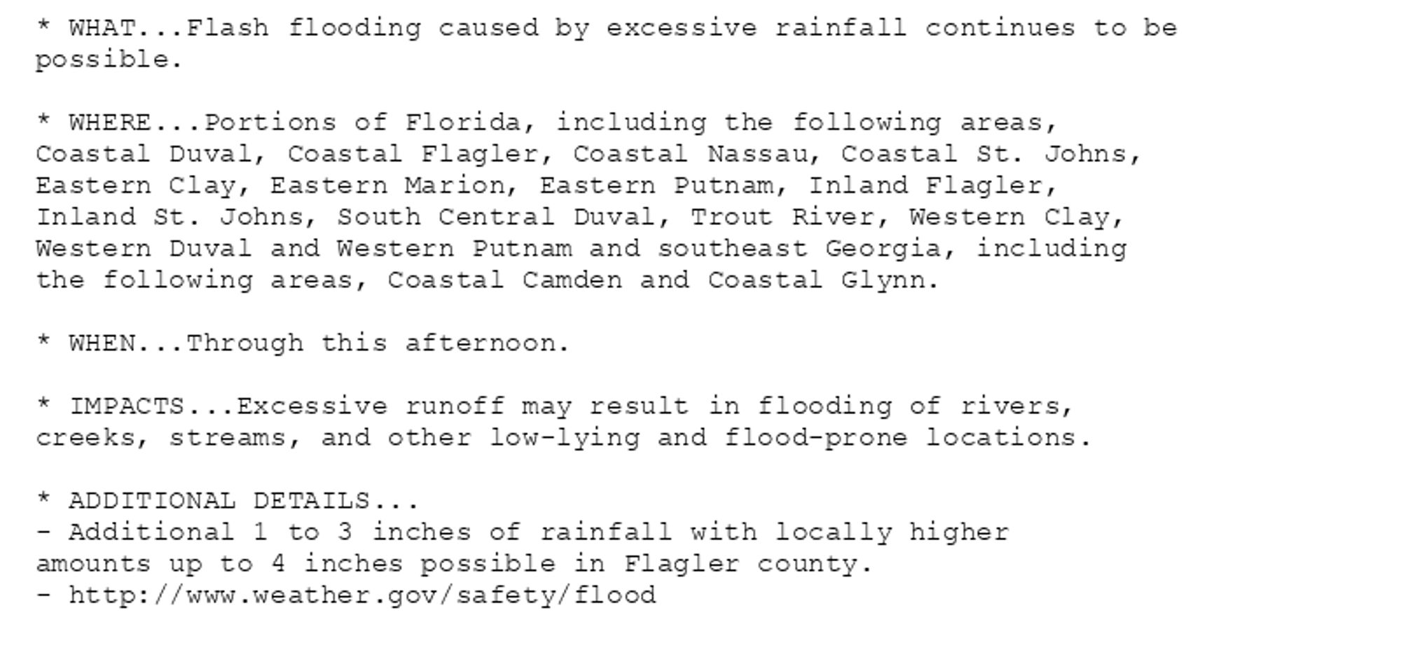
🚨 Flood Watch issued October 10 at 4:14AM EDT until October 10 at 6:00PM EDT by NWS Jacksonville FL 🚨 Additional Details Here.

* WHAT...Flash flooding caused by excessive rainfall continues to be
possible.

* WHERE...Portions of Florida, including the following areas,
Coastal Duval, Coastal Flagler, Coastal Nassau, Coastal St. Johns,
Eastern Clay, Eastern Marion, Eastern Putnam, Inland Flagler,
Inland St. Johns, South Central Duval, Trout River, Western Clay,
Western Duval and Western Putnam and southeast Georgia, including
the following areas, Coastal Camden and Coastal Glynn.

* WHEN...Through this afternoon.

* IMPACTS...Excessive runoff may result in flooding of rivers,
creeks, streams, and other low-lying and flood-prone locations.

* ADDITIONAL DETAILS...
- Additional 1 to 3 inches of rainfall with locally higher
amounts up to 4 inches possible in Flagler county.
- http://www.weather.gov/safety/flood
0