BLUE
Profile banner
NF
Nathan Foster
@natfos.bsky.social
The cool, refreshing air of a window A/C unit
18 followers122 following146 posts
NFnatfos.bsky.social

And the moderation problem is a harder problem because itā€™s about $$$. Facebook has the money to do moderation but chose not to; I have trouble seeing a company like Bluesky ever having a large staff-to-user ratio. So how does moderation scale with the platform? Does it just have to be volunteers?

1
NFnatfos.bsky.social

100%. The blocks and custom feeds are a really interesting experiment in that regard - if the user is a more active participant in what they get shown, the model of being outrageous for views and engagement may be less effective. But itā€™s a really hard problem to wrap my head around

1
NFnatfos.bsky.social

If itā€™s about how the network is structured, you can theoretically maintain light-touch moderation while being thoughtful w/the platformā€™s design. If itā€™s fundamental to human nature that hate speech will pop up anywhere that doesnā€™t actively suppress it, Bluesky is gonna need more staff/volunteers

1
NFnatfos.bsky.social

I guess the first question is, what characteristics of social media sites make them so useful for disseminating hate speech in the first place?

1
Reposted by Nathan Foster
Nnpr.org

In communications newly revealed, TikTok executives discuss being aware of the harms caused by their app. TikTok officials were warned of the appā€™s dangers to minors.

States probed TikTok for years. Here are the documents the app tried to keep secret

In communications newly revealed, TikTok executives discuss being aware of the harms caused by their app. TikTok officials were warned of the appā€™s dangers to minors.

12
NFnatfos.bsky.social

FWIW, I think this headline is correct. Tim Walz literally went after Trump in the vice-presidential debate for breaking his promises by *not* building a border wall.

1
Reposted by Nathan Foster
NHnhc-atlc.nws-bot.us

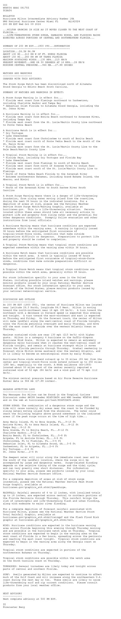
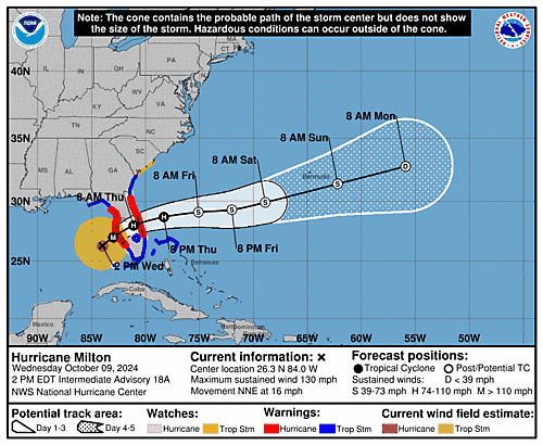
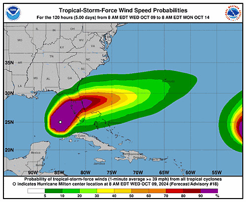
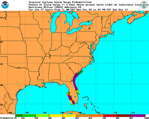
Atlantic Hurricane Milton Intermediate Advisory Number 18A ...MILTON GROWING IN SIZE AS IT MOVES CLOSER TO THE WEST COAST OF FLORIDA... ...LIFE-THREATENING STORM SURGE, DAMAGING WINDS, AND FLOODING RAINS EXPECTED ACROSS PORTIONS OF CENTRAL AND SOUTHWESTERN FLOR... Additional Details Here.


 <br />
 000<br />
 WTNT34 KNHC 091755<br />
 TCPAT4<br />
  <br />
 BULLETIN<br />
 Hurricane Milton Intermediate Advisory Number 18A<br />
 NWS National Hurricane Center Miami FL       AL142024<br />
 200 PM EDT Wed Oct 09 2024<br />
  <br />
 ...MILTON GROWING IN SIZE AS IT MOVES CLOSER TO THE WEST COAST OF <br />
 FLORIDA...<br />
 ...LIFE-THREATENING STORM SURGE, DAMAGING WINDS, AND FLOODING RAINS <br />
 EXPECTED ACROSS PORTIONS OF CENTRAL AND SOUTHWESTERN FLORIDA...<br />
  <br />
  <br />
 SUMMARY OF 200 PM EDT...1800 UTC...INFORMATION<br />
 ----------------------------------------------<br />
 LOCATION...26.3N 84.0W<br />
 ABOUT 130 MI...210 KM W OF FT. MYERS FLORIDA<br />
 ABOUT 150 MI...240 KM SW OF TAMPA FLORIDA<br />
 MAXIMUM SUSTAINED WINDS...130 MPH...215 KM/H<br />
 PRESENT MOVEMENT...NNE OR 30 DEGREES AT 16 MPH...26 KM/H<br />
 MINIMUM CENTRAL PRESSURE...944 MB...27.88 INCHES<br />
  <br />
  <br />
 WATCHES AND WARNINGS<br />
 --------------------<br />
 CHANGES WITH THIS ADVISORY:<br />
  <br />
 The Storm Surge Watch has been discontinued north of Altamaha <br />
 Sound Georgia to Edisto Beach South Carolina.<br />
  <br />
 SUMMARY OF WATCHES AND WARNINGS IN EFFECT:<br />
  <br />
 A Storm Surge Warning is in effect for...<br />
 * Florida west coast from Flamingo northward to Yankeetown,<br />
 including Charlotte Harbor and Tampa Bay<br />
 * Sebastian Inlet Florida to Altamaha Sound Georgia, including the<br />
 St. Johns River<br />
  <br />
 A Hurricane Warning is in effect for...<br />
 * Florida west coast from Bonita Beach northward to Suwannee River,<br />
 including Tampa Bay<br />
 * Florida east coast from the St. Lucie/Martin County Line northward<br />
 to Ponte Vedra Beach<br />
  <br />
 A Hurricane Watch is in effect for...<br />
 * Dry Tortugas<br />
 * Lake Okeechobee<br />
 * Florida west coast from Chokoloskee to south of Bonita Beach<br />
 * Florida east coast north of Ponte Vedra Beach to the mouth of the<br />
 St. Marys River<br />
 * Florida east coast from the St. Lucie/Martin County Line to the<br />
 Palm Beach/Martin County Line<br />
  <br />
 A Tropical Storm Warning is in effect for...<br />
 * Florida Keys, including Dry Tortugas and Florida Bay<br />
 * Lake Okeechobee<br />
 * Florida west coast from Flamingo to south of Bonita Beach<br />
 * Florida west coast from north of Suwanee River to Indian Pass<br />
 * Florida east coast south of the St. Lucie/Martin County Line to<br />
 Flamingo<br />
 * North of Ponte Vedra Beach Florida to the Savannah River<br />
 * Extreme northwestern Bahamas, including Grand Bahama Island, the<br />
 Abacos, and Bimini<br />
  <br />
 A Tropical Storm Watch is in effect for...<br />
 * North of the Savannah River to South Santee River South<br />
 Carolina<br />
  <br />
 A Storm Surge Warning means there is a danger of life-threatening<br />
 inundation, from rising water moving inland from the coastline,<br />
 during the next 36 hours in the indicated locations. For a<br />
 depiction of areas at risk, please see the National Weather<br />
 Service Storm Surge Watch/Warning Graphic, available at<br />
 hurricanes.gov.  This is a life-threatening situation.  Persons<br />
 located within these areas should take all necessary actions to<br />
 protect life and property from rising water and the potential for<br />
 other dangerous conditions.  Promptly follow evacuation and other<br />
 instructions from local officials.<br />
  <br />
 A Hurricane Warning means that hurricane conditions are expected<br />
 somewhere within the warning area.  A warning is typically issued<br />
 36 hours before the anticipated first occurrence of<br />
 tropical-storm-force winds, conditions that make outside<br />
 preparations difficult or dangerous.  Preparations to protect life<br />
 and property should be rushed to completion.<br />
  <br />
 A Tropical Storm Warning means that tropical storm conditions are<br />
 expected somewhere within the warning area within 36 hours.<br />
  <br />
 A Hurricane Watch means that hurricane conditions are possible<br />
 within the watch area.  A watch is typically issued 48 hours<br />
 before the anticipated first occurrence of tropical-storm-force<br />
 winds, conditions that make outside preparations difficult or<br />
 dangerous.<br />
  <br />
 A Tropical Storm Watch means that tropical storm conditions are<br />
 possible within the watch area, generally within 48 hours.<br />
  <br />
 For storm information specific to your area in the United<br />
 States, including possible inland watches and warnings, please<br />
 monitor products issued by your local National Weather Service<br />
 forecast office. For storm information specific to your area<br />
 outside of the United States, please monitor products issued by<br />
 your national meteorological service.<br />
  <br />
  <br />
 DISCUSSION AND OUTLOOK<br />
 ----------------------<br />
 At 200 PM EDT (1800 UTC), the center of Hurricane Milton was located<br />
 near latitude 26.3 North, longitude 84.0 West.  Milton is moving<br />
 toward the north-northeast near 16 mph (26 km/h).  A turn toward the <br />
 northeast with a decrease in forward speed is expected this evening <br />
 and tonight.  A turn toward the east-northeast and east is expected <br />
 on Thursday and Friday.  On the forecast track, the center of Milton<br />
 will make landfall along the west-central coast of Florida tonight, <br />
 cross the Florida peninsula overnight and early Thursday, and move <br />
 off the east coast of Florida over the western Atlantic Ocean on <br />
 Thursday.<br />
  <br />
 Maximum sustained winds are near 130 mph (215 km/h) with higher<br />
 gusts.  Milton is a category 4 hurricane on the Saffir-Simpson<br />
 Hurricane Wind Scale.  Milton is expected to remain an extremely<br />
 dangerous major hurricane when it reaches the west-central coast of<br />
 Florida tonight, and remain at hurricane strength while it moves<br />
 across the Florida peninsula through Thursday.  Gradual weakening is<br />
 forecast while Milton moves eastward over the western Atlantic, and<br />
 it is likely to become an extratropical storm by early Friday.<br />
  <br />
 Hurricane-force winds extend outward up to 35 miles (55 km) from the <br />
 center and tropical-storm-force winds extend outward up to 250 miles <br />
 (280 km), especially to the north. A NOAA saildrone (SD-1083) <br />
 located about 50 miles east of the center recently reported a <br />
 sustained wind of 52 mph (84 km/h) and a wind gust of 70 mph (112 <br />
 km/h).<br />
  <br />
 The minimum central pressure based on Air Force Reserve Hurricane<br />
 Hunter data is 944 mb (27.88 inches).<br />
  <br />
  <br />
 HAZARDS AFFECTING LAND<br />
 ----------------------<br />
 Key Messages for Milton can be found in the Tropical Cyclone<br />
 Discussion under AWIPS header MIATCDAT4 and WMO header WTNT44 KNHC<br />
 and on the web at hurricanes.gov/text/MIATCDAT4.shtml<br />
  <br />
 STORM SURGE: The combination of a dangerous storm surge and the<br />
 tide will cause normally dry areas near the coast to be flooded by<br />
 rising waters moving inland from the shoreline.  The water could<br />
 reach the following heights above ground somewhere in the indicated<br />
 areas if the peak surge occurs at the time of high tide...<br />
  <br />
 Anna Maria Island, FL to Boca Grande, FL...9-13 ft<br />
 Anclote River, FL to Anna Maria Island, FL...8-12 ft<br />
 Tampa Bay...8-12 ft<br />
 Boca Grande, FL to Bonita Beach, FL...8-12 ft<br />
 Charlotte Harbor...8-12 ft<br />
 Bonita Beach, FL to Chokoloskee, FL...5-8 ft<br />
 Aripeka, FL to Anclote River, FL...3-5 ft<br />
 Chokoloskee, FL to Flamingo, FL...3-5 ft<br />
 Sebastian Inlet, FL to Altamaha Sound, GA...3-5 ft<br />
 Yankeetown, FL to Aripeka, FL...2-4 ft<br />
 Dry Tortugas...2-4 ft<br />
 St. Johns River...2-4 ft<br />
  <br />
 The deepest water will occur along the immediate coast near and to<br />
 the south of the landfall location, where the surge will be<br />
 accompanied by large and dangerous waves.  Surge-related flooding<br />
 depends on the relative timing of the surge and the tidal cycle,<br />
 and can vary greatly over short distances.  For information<br />
 specific to your area, please see products issued by your local<br />
 National Weather Service forecast office.<br />
  <br />
 For a complete depiction of areas at risk of storm surge<br />
 inundation, please see the National Weather Service Peak Storm<br />
 Surge Graphic, available at<br />
 hurricanes.gov/graphics_at4.shtml?peakSurge.<br />
  <br />
 RAINFALL: Rainfall amounts of 6 to 12 inches, with localized totals<br />
 up to 18 inches, are expected across central to northern portions of<br />
 the Florida Peninsula through Thursday.  This rainfall brings the<br />
 risk of catastrophic and life-threatening flash and urban flooding,<br />
 along with moderate to major river flooding.<br />
  <br />
 For a complete depiction of forecast rainfall associated with<br />
 Hurricane Milton, please see the National Weather Service Storm<br />
 Total Rainfall Graphic, available at<br />
 hurricanes.gov/graphics_at4.shtml?rainqpf and the Flash Flood Risk<br />
 graphic at hurricanes.gov/graphics_at4.shtml?ero.<br />
  <br />
 WIND: Hurricane conditions are expected in the hurricane warning<br />
 area across Florida beginning this evening through Thursday morning<br />
 and are possible in the hurricane watch area on Thursday.  Tropical<br />
 storm conditions are expected to begin in the warning area on the<br />
 west coast of Florida in a few hours, spreading across the peninsula<br />
 and reaching the east coast tonight.  Tropical storm conditions are<br />
 expected to begin in the warning area along the Georgia coast on<br />
 Thursday.<br />
  <br />
 Tropical storm conditions are expected in portions of the<br />
 northwestern Bahamas on Thursday.<br />
  <br />
 Tropical storm conditions are possible within the watch area<br />
 on the South Carolina coast on Thursday.<br />
  <br />
 TORNADOES: Several tornadoes are likely today and tonight across<br />
 parts of central and southern Florida.<br />
  <br />
 SURF:  Swells generated by Milton are expected to continue to affect<br />
 much of the Gulf Coast and will increase along the southeastern U.S.<br />
 coast during the next day or two.  These swells are likely to cause<br />
 life-threatening surf and rip current conditions.  Please consult<br />
 products from your local weather office.<br />
  <br />
  <br />
 NEXT ADVISORY<br />
 -------------<br />
 Next complete advisory at 500 PM EDT.<br />
  <br />
 $$<br />
 Forecaster Berg<br />
  <br />
Hurricane Milton 5-Day Uncertainty Track Image
Hurricane Milton 34-Knot Wind Speed Probabilities
Hurricane Milton Probabilistic Storm Surge Graphics Image
3
NFnatfos.bsky.social

šŸ‡±šŸ‡§šŸ’”

0
Reposted by Nathan Foster
DLdavelevitan.bsky.social

Will the world never be rid of the fucking Sacklers (gift link, really impressive multi-country/multi-outlet investigation)Will the world never be rid of the fucking Sacklers (gift link, really impressive multi-country/multi-outlet investigation)

In the U.S., opioid-maker Purdue is bankrupt. Its global counterparts make millions.

Tactics used to persuade U.S. doctors that potent painkillers could be safely prescribed have been used abroad, an investigation shows.

3
Profile banner
NF
Nathan Foster
@natfos.bsky.social
The cool, refreshing air of a window A/C unit
18 followers122 following146 posts