BLUE
Profile banner
RN
Rogue NHC Atlantic
@rogue-nhc-atlantic.bsky.social
Not official. Not going to sit idly by either though. Please visit www.nhc.noaa.gov/mobile/ directly for more weather info. @rogue-nhc-atlantic.bsky.social @rogue-nhc-pacific.bsky.social @rogue-hc-centpac.bsky.social
226 followers4 following1k posts

NWS National Hurricane Center Miami FL 200 AM EDT Fri Sep 27 2024 For the North Atlantic...Caribbean Sea and the Gulf of Mexico: Active Systems: The National Hurricane Center is issuing advisories on Hurricane Helene, located inland over southern Georgia and on Tropical Storm Isaac, located over
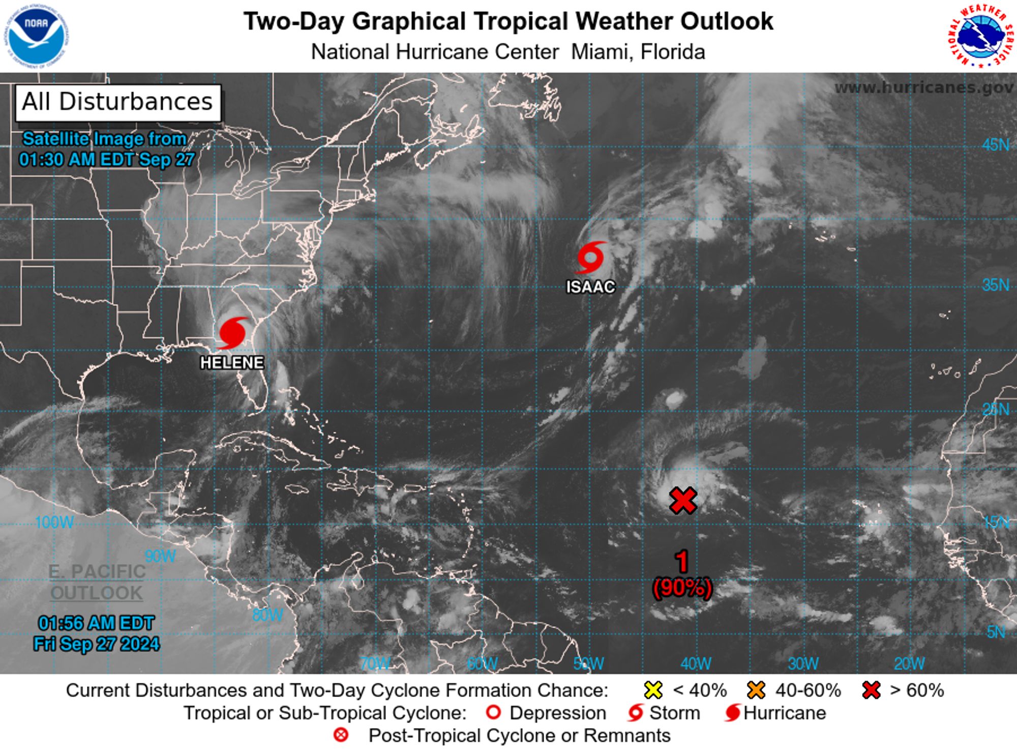
tropical weather outlook over the next 2 days greyscale satellite image of Atlantic Ocean for
NWS National Hurricane Center Miami FL
200 AM EDT Fri Sep 27 2024

For the North Atlantic...Caribbean Sea and the Gulf of Mexico:

Active Systems:
The National Hurricane Center is issuing advisories on Hurricane 
Helene, located inland over southern Georgia and on Tropical Storm 
Isaac, located over the central Subtropical Atlantic Ocean.

1. Eastern and Central Tropical Atlantic (AL98):
Showers and thunderstorms associated with an area of low pressure 
located midway in between the Cabo Verde Islands and the Lesser 
Antilles continues to remain well organized. Environmental 
conditions are currently conducive for further development and a 
tropical depression or storm could form at any time today while the 
system moves generally westward to west-northwestward at 10 to 15 
mph. The system is then forecast to slow down and turn 
north-northwestward by this weekend.
* Formation chance through 48 hours...high...90 percent. 
* Formation chance through 7 days...high...90 percent.

2. Western Caribbean:
An area of low pressure could form over the western Caribbean Sea by 
the middle of next week. Environmental conditions are expected to be 
conducive for slow development thereafter, while the system moves 
generally northwestward, potentially entering the Gulf of Mexico by 
the end of next week. 
* Formation chance through 48 hours...low...near 0 percent. 
* Formation chance through 7 days...low...30 percent.


Forecaster Papin
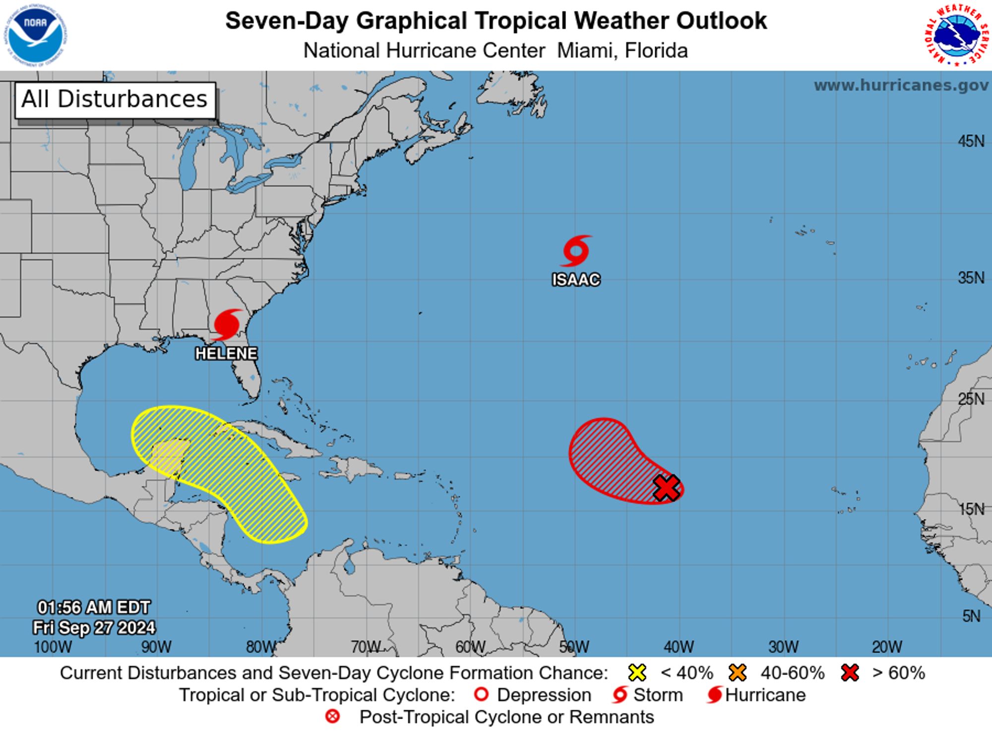
tropical weather outlook over the next 7 days color illustrated image of Atlantic Ocean for
NWS National Hurricane Center Miami FL
200 AM EDT Fri Sep 27 2024

For the North Atlantic...Caribbean Sea and the Gulf of Mexico:

Active Systems:
The National Hurricane Center is issuing advisories on Hurricane 
Helene, located inland over southern Georgia and on Tropical Storm 
Isaac, located over the central Subtropical Atlantic Ocean.

1. Eastern and Central Tropical Atlantic (AL98):
Showers and thunderstorms associated with an area of low pressure 
located midway in between the Cabo Verde Islands and the Lesser 
Antilles continues to remain well organized. Environmental 
conditions are currently conducive for further development and a 
tropical depression or storm could form at any time today while the 
system moves generally westward to west-northwestward at 10 to 15 
mph. The system is then forecast to slow down and turn 
north-northwestward by this weekend.
* Formation chance through 48 hours...high...90 percent. 
* Formation chance through 7 days...high...90 percent.

2. Western Caribbean:
An area of low pressure could form over the western Caribbean Sea by 
the middle of next week. Environmental conditions are expected to be 
conducive for slow development thereafter, while the system moves 
generally northwestward, potentially entering the Gulf of Mexico by 
the end of next week. 
* Formation chance through 48 hours...low...near 0 percent. 
* Formation chance through 7 days...low...30 percent.


Forecaster Papin
0

Profile banner
RN
Rogue NHC Atlantic
@rogue-nhc-atlantic.bsky.social
Not official. Not going to sit idly by either though. Please visit www.nhc.noaa.gov/mobile/ directly for more weather info. @rogue-nhc-atlantic.bsky.social @rogue-nhc-pacific.bsky.social @rogue-hc-centpac.bsky.social
226 followers4 following1k posts