BLUE
ST
SPC Tornado/Severe Thunderstorm Alerts (UNOFFICIAL)
@spc-storms.nws-bot.us
Unofficial bot sharing alerts from SPC Tornado/Severe Thunderstorm Watches. This account is not monitored. Contact @wandrme.paxex.aero if needed.
20 followers1 following62 posts
STspc-storms.nws-bot.us

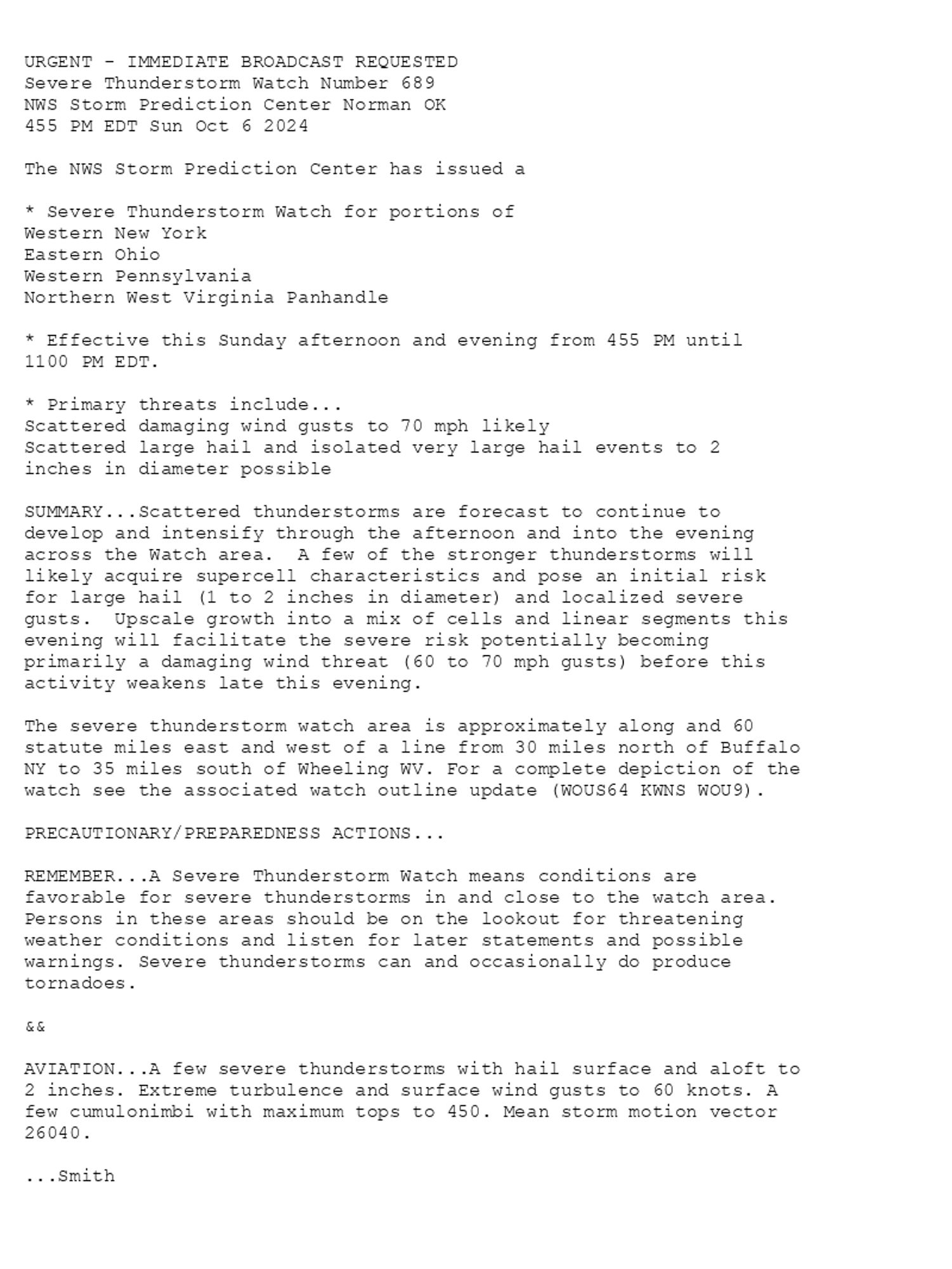
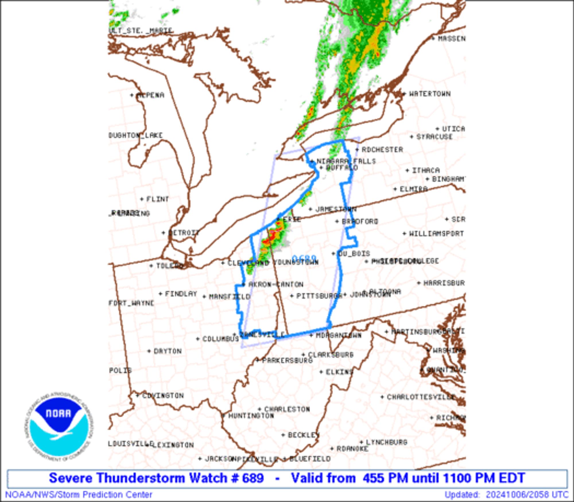
SPC Severe Thunderstorm Watch 689 ⛈️ Scattered damaging wind gusts to 70 mph likely Scattered large hail and isolated very large hail events to 2 inches in diameter possible SUMMARY🌪️ Additional Details Here.


URGENT - IMMEDIATE BROADCAST REQUESTED
Severe Thunderstorm Watch Number 689
NWS Storm Prediction Center Norman OK
455 PM EDT Sun Oct 6 2024

The NWS Storm Prediction Center has issued a

* Severe Thunderstorm Watch for portions of 
  Western New York
  Eastern Ohio
  Western Pennsylvania
  Northern West Virginia Panhandle

* Effective this Sunday afternoon and evening from 455 PM until
  1100 PM EDT.

* Primary threats include...
  Scattered damaging wind gusts to 70 mph likely
  Scattered large hail and isolated very large hail events to 2
    inches in diameter possible

SUMMARY...Scattered thunderstorms are forecast to continue to
develop and intensify through the afternoon and into the evening
across the Watch area.  A few of the stronger thunderstorms will
likely acquire supercell characteristics and pose an initial risk
for large hail (1 to 2 inches in diameter) and localized severe
gusts.  Upscale growth into a mix of cells and linear segments this
evening will facilitate the severe risk potentially becoming
primarily a damaging wind threat (60 to 70 mph gusts) before this
activity weakens late this evening.

The severe thunderstorm watch area is approximately along and 60
statute miles east and west of a line from 30 miles north of Buffalo
NY to 35 miles south of Wheeling WV. For a complete depiction of the
watch see the associated watch outline update (WOUS64 KWNS WOU9).

PRECAUTIONARY/PREPAREDNESS ACTIONS...

REMEMBER...A Severe Thunderstorm Watch means conditions are
favorable for severe thunderstorms in and close to the watch area.
Persons in these areas should be on the lookout for threatening
weather conditions and listen for later statements and possible
warnings. Severe thunderstorms can and occasionally do produce
tornadoes.

&&

AVIATION...A few severe thunderstorms with hail surface and aloft to
2 inches. Extreme turbulence and surface wind gusts to 60 knots. A
few cumulonimbi with maximum tops to 450. Mean storm motion vector
26040.

...Smith
WW 0689 Image
0

ST
SPC Tornado/Severe Thunderstorm Alerts (UNOFFICIAL)
@spc-storms.nws-bot.us
Unofficial bot sharing alerts from SPC Tornado/Severe Thunderstorm Watches. This account is not monitored. Contact @wandrme.paxex.aero if needed.
20 followers1 following62 posts