BLUE
ST
SPC Tornado/Severe Thunderstorm Alerts (UNOFFICIAL)
@spc-storms.nws-bot.us
Unofficial bot sharing alerts from SPC Tornado/Severe Thunderstorm Watches. This account is not monitored. Contact @wandrme.paxex.aero if needed.
23 followers1 following112 posts
STspc-storms.nws-bot.us

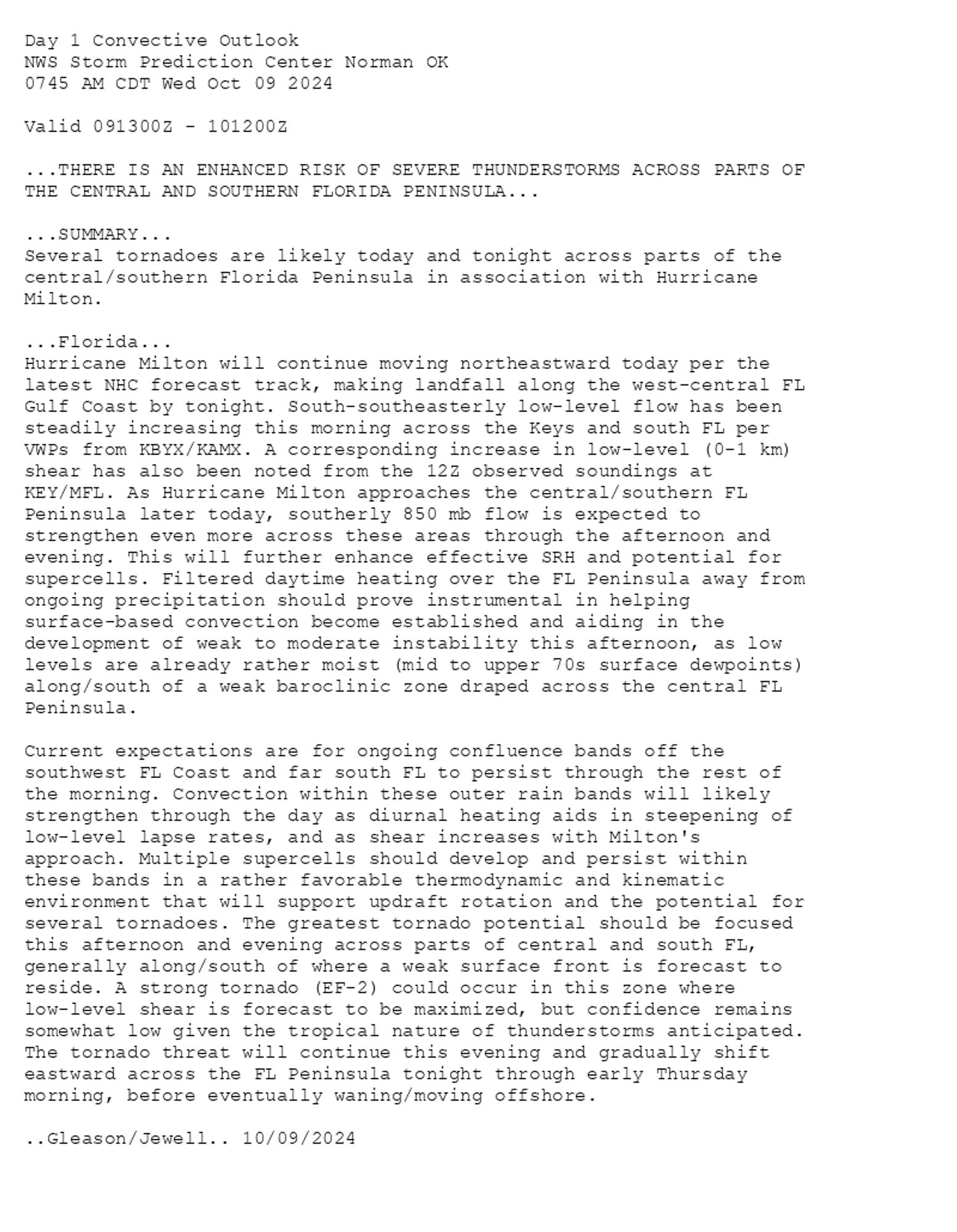
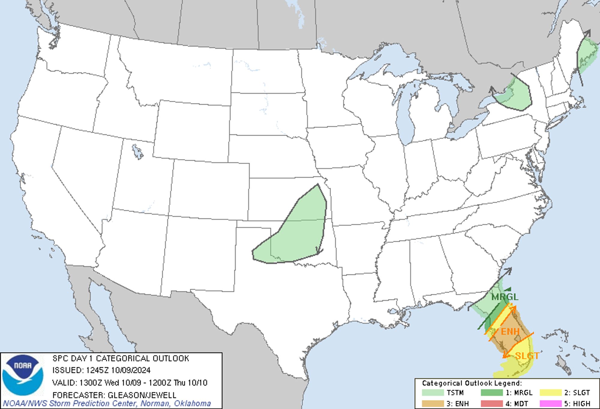
SPC Oct 9, 2024 1300 UTC Day 1 Convective Outlook ⛈️THERE IS AN ENHANCED RISK OF SEVERE THUNDERSTORMS ACROSS PARTS OF THE CENTRAL AND SOUTHERN FLORIDA PENINSULA🌪️ Additional Details Here.


Day 1 Convective Outlook  
NWS Storm Prediction Center Norman OK
0745 AM CDT Wed Oct 09 2024

Valid 091300Z - 101200Z

...THERE IS AN ENHANCED RISK OF SEVERE THUNDERSTORMS ACROSS PARTS OF
THE CENTRAL AND SOUTHERN FLORIDA PENINSULA...

...SUMMARY...
Several tornadoes are likely today and tonight across parts of the
central/southern Florida Peninsula in association with Hurricane
Milton.

...Florida...
Hurricane Milton will continue moving northeastward today per the
latest NHC forecast track, making landfall along the west-central FL
Gulf Coast by tonight. South-southeasterly low-level flow has been
steadily increasing this morning across the Keys and south FL per
VWPs from KBYX/KAMX. A corresponding increase in low-level (0-1 km)
shear has also been noted from the 12Z observed soundings at
KEY/MFL. As Hurricane Milton approaches the central/southern FL
Peninsula later today, southerly 850 mb flow is expected to
strengthen even more across these areas through the afternoon and
evening. This will further enhance effective SRH and potential for
supercells. Filtered daytime heating over the FL Peninsula away from
ongoing precipitation should prove instrumental in helping
surface-based convection become established and aiding in the
development of weak to moderate instability this afternoon, as low
levels are already rather moist (mid to upper 70s surface dewpoints)
along/south of a weak baroclinic zone draped across the central FL
Peninsula.

Current expectations are for ongoing confluence bands off the
southwest FL Coast and far south FL to persist through the rest of
the morning. Convection within these outer rain bands will likely
strengthen through the day as diurnal heating aids in steepening of
low-level lapse rates, and as shear increases with Milton's
approach. Multiple supercells should develop and persist within
these bands in a rather favorable thermodynamic and kinematic
environment that will support updraft rotation and the potential for
several tornadoes. The greatest tornado potential should be focused
this afternoon and evening across parts of central and south FL,
generally along/south of where a weak surface front is forecast to
reside. A strong tornado (EF-2) could occur in this zone where
low-level shear is forecast to be maximized, but confidence remains
somewhat low given the tropical nature of thunderstorms anticipated.
The tornado threat will continue this evening and gradually shift
eastward across the FL Peninsula tonight through early Thursday
morning, before eventually waning/moving offshore.

..Gleason/Jewell.. 10/09/2024
Day 1 Outlook Image
0

ST
SPC Tornado/Severe Thunderstorm Alerts (UNOFFICIAL)
@spc-storms.nws-bot.us
Unofficial bot sharing alerts from SPC Tornado/Severe Thunderstorm Watches. This account is not monitored. Contact @wandrme.paxex.aero if needed.
23 followers1 following112 posts