BLUE
AF
Alerts from NWS Baltimore MD/Washington DC (UNOFFICIAL)
@was.nws-bot.us
Unofficial bot sharing NWS alerts for the Baltimore MD/Washington DC area. This account is not monitored. Contact @wandrme.paxex.aero if needed.
952 followers1 following410 posts
AFwas.nws-bot.us

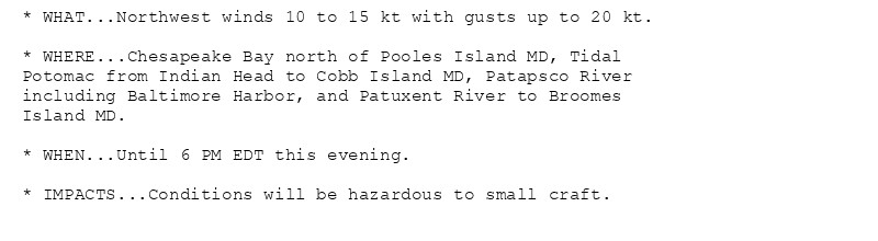
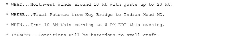
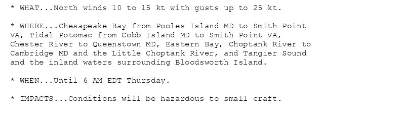
Small Craft Advisory issued October 16 at 1:11AM EDT until October 16 at 6:00PM EDT by NWS Baltimore MD/Washington DC Additional Details Here.

* WHAT...Northwest winds 10 to 15 kt with gusts up to 20 kt.

* WHERE...Chesapeake Bay north of Pooles Island MD, Tidal
Potomac from Indian Head to Cobb Island MD, Patapsco River
including Baltimore Harbor, and Patuxent River to Broomes
Island MD.

* WHEN...Until 6 PM EDT this evening.

* IMPACTS...Conditions will be hazardous to small craft.
* WHAT...Northwest winds around 10 kt with gusts up to 20 kt.

* WHERE...Tidal Potomac from Key Bridge to Indian Head MD.

* WHEN...From 10 AM this morning to 6 PM EDT this evening.

* IMPACTS...Conditions will be hazardous to small craft.
* WHAT...North winds 10 to 15 kt with gusts up to 25 kt.

* WHERE...Chesapeake Bay from Pooles Island MD to Smith Point
VA, Tidal Potomac from Cobb Island MD to Smith Point VA,
Chester River to Queenstown MD, Eastern Bay, Choptank River to
Cambridge MD and the Little Choptank River, and Tangier Sound
and the inland waters surrounding Bloodsworth Island.

* WHEN...Until 6 AM EDT Thursday.

* IMPACTS...Conditions will be hazardous to small craft.
0

AF
Alerts from NWS Baltimore MD/Washington DC (UNOFFICIAL)
@was.nws-bot.us
Unofficial bot sharing NWS alerts for the Baltimore MD/Washington DC area. This account is not monitored. Contact @wandrme.paxex.aero if needed.
952 followers1 following410 posts