BLUE
Kstarsea.quest

Maybe save the rage for generative AI and war and gas lobbies hastening climate change instead of telling people they have to move from their homes. Utterly ignoring "the places that are 'safe' are vanishingly few" and "okay but what about food and farmland"! Also hello gerrymandering?

1
GPgregpak.bsky.social

Wrote ten more Postcards to Swing States. Chipping away at 'em! #DidThisTodayturnoutpac.org/postcards/

A few postcards reading "Pennsylvania Votes Tuesday, Nov 5 / Visit VotingMattersPA.org for voting info" against an image of farmland.
3
EWrootofalleli.bsky.social

I feel like when some corporation is able to secure a great deal on farmland somewhere we're propping up the shitty government, and then land people have lived off since god knows how long starts turning into desert so we can eat what we want, that's maybe a bit of us too

0
AFcae.nws-bot.us

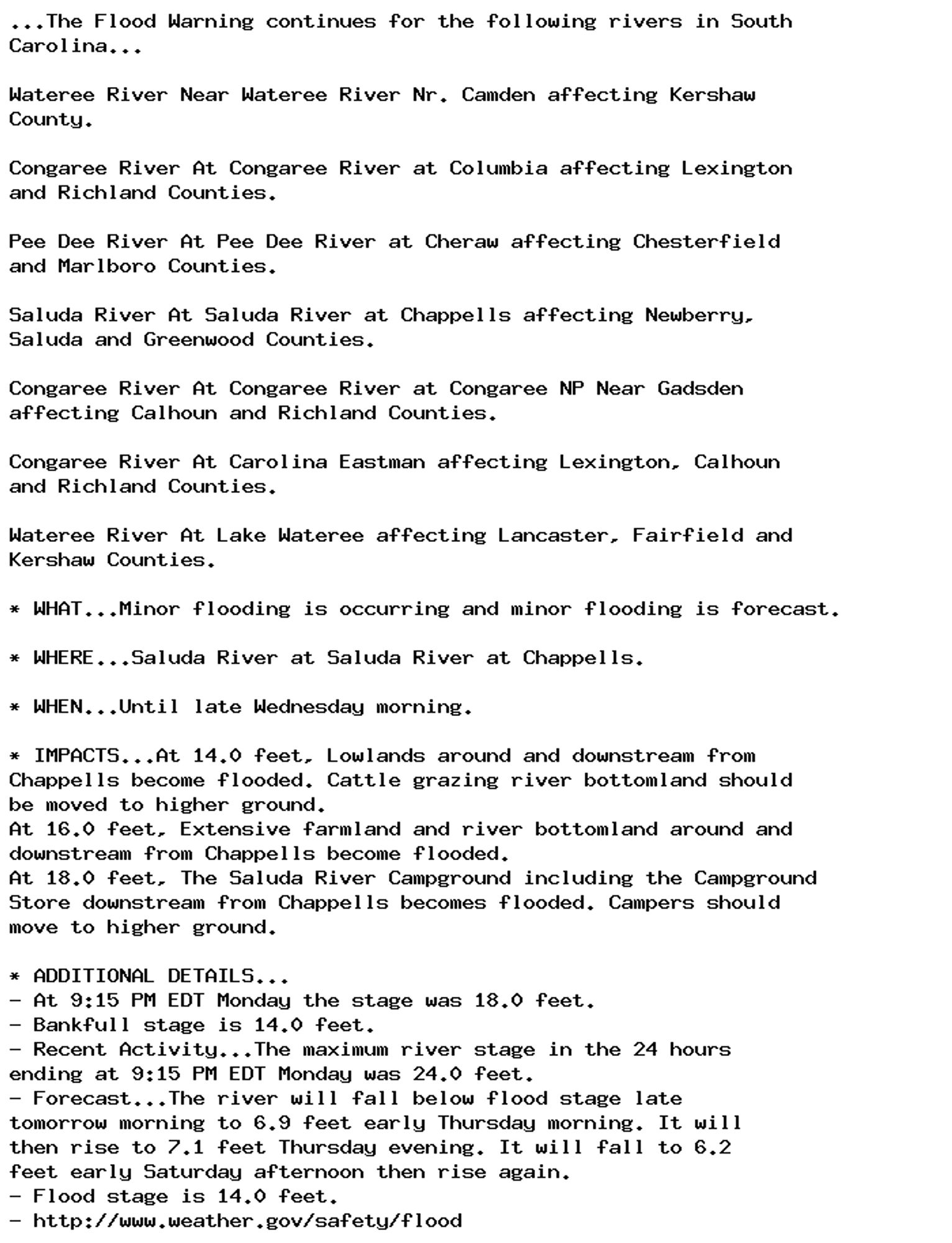
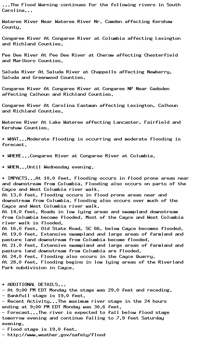
🚨 Flood Warning issued September 30 at 10:10PM EDT until October 2 at 10:52AM EDT by NWS Columbia SC 🚨 Additional Details Here.

...The Flood Warning continues for the following rivers in South
Carolina...

Wateree River Near Wateree River Nr. Camden affecting Kershaw
County.

Congaree River At Congaree River at Columbia affecting Lexington
and Richland Counties.

Pee Dee River At Pee Dee River at Cheraw affecting Chesterfield
and Marlboro Counties.

Saluda River At Saluda River at Chappells affecting Newberry,
Saluda and Greenwood Counties.

Congaree River At Congaree River at Congaree NP Near Gadsden
affecting Calhoun and Richland Counties.

Congaree River At Carolina Eastman affecting Lexington, Calhoun
and Richland Counties.

Wateree River At Lake Wateree affecting Lancaster, Fairfield and
Kershaw Counties.

* WHAT...Minor flooding is occurring and minor flooding is forecast.

* WHERE...Saluda River at Saluda River at Chappells.

* WHEN...Until late Wednesday morning.

* IMPACTS...At 14.0 feet, Lowlands around and downstream from
Chappells become flooded. Cattle grazing river bottomland should
be moved to higher ground.
At 16.0 feet, Extensive farmland and river bottomland around and
downstream from Chappells become flooded.
At 18.0 feet, The Saluda River Campground including the Campground
Store downstream from Chappells becomes flooded. Campers should
move to higher ground.

* ADDITIONAL DETAILS...
- At 9:15 PM EDT Monday the stage was 18.0 feet.
- Bankfull stage is 14.0 feet.
- Recent Activity...The maximum river stage in the 24 hours
ending at 9:15 PM EDT Monday was 24.0 feet.
- Forecast...The river will fall below flood stage late
tomorrow morning to 6.9 feet early Thursday morning. It will
then rise to 7.1 feet Thursday evening. It will fall to 6.2
feet early Saturday afternoon then rise again.
- Flood stage is 14.0 feet.
- http://www.weather.gov/safety/flood
0
AFcae.nws-bot.us

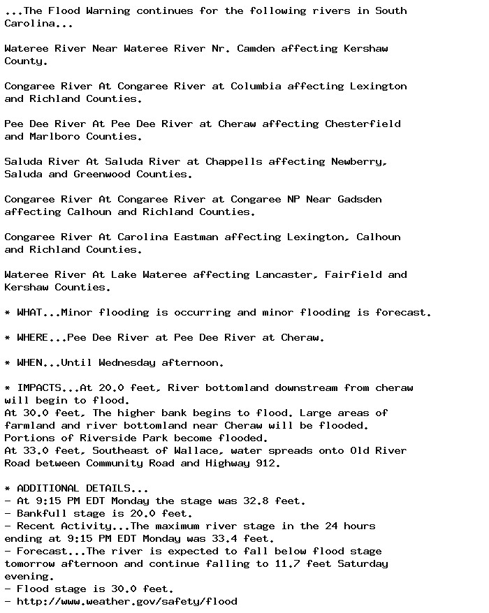
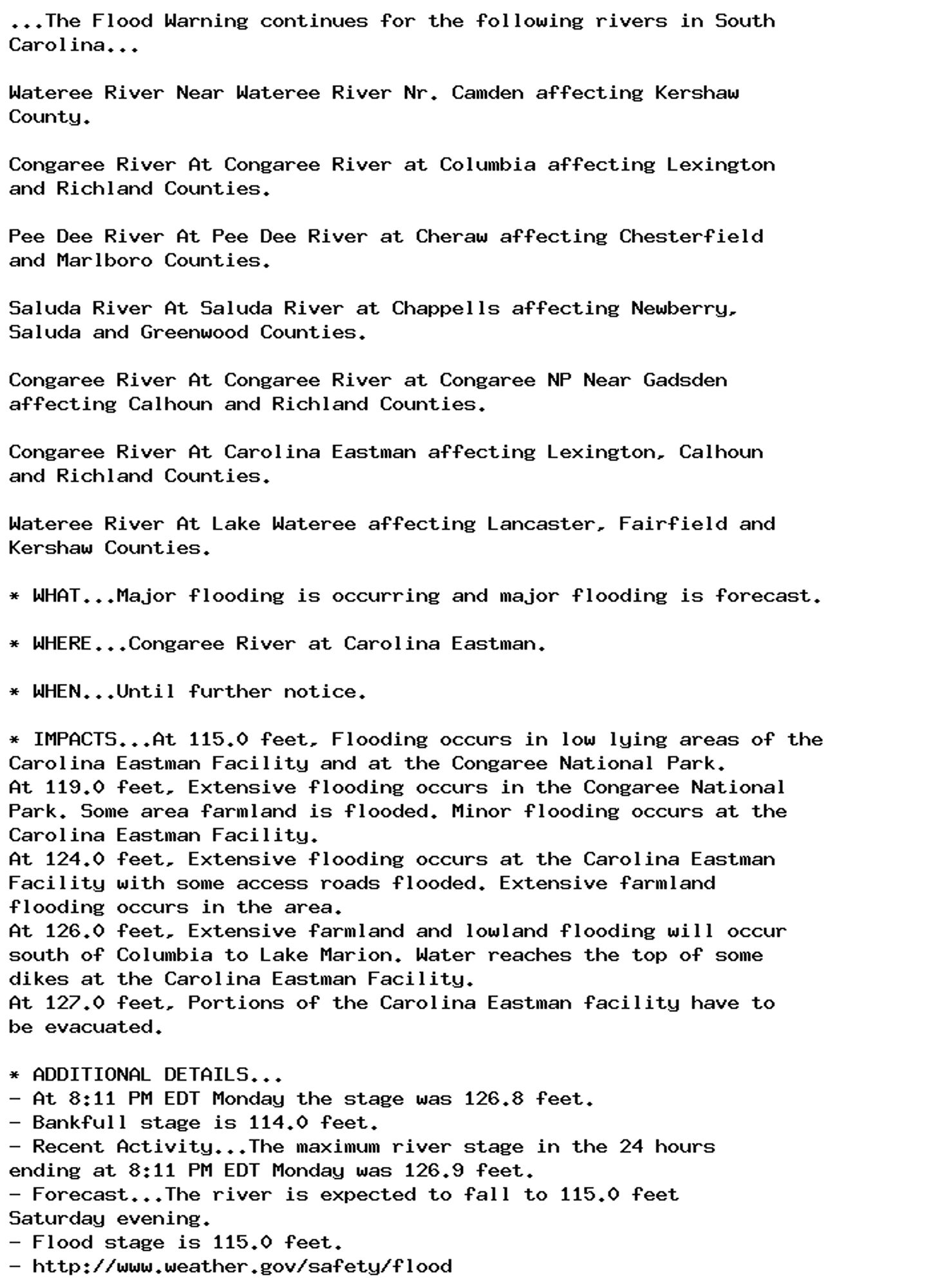
🚨 Flood Warning issued September 30 at 10:10PM EDT until October 2 at 3:12PM EDT by NWS Columbia SC 🚨 Additional Details Here.

...The Flood Warning continues for the following rivers in South
Carolina...

Wateree River Near Wateree River Nr. Camden affecting Kershaw
County.

Congaree River At Congaree River at Columbia affecting Lexington
and Richland Counties.

Pee Dee River At Pee Dee River at Cheraw affecting Chesterfield
and Marlboro Counties.

Saluda River At Saluda River at Chappells affecting Newberry,
Saluda and Greenwood Counties.

Congaree River At Congaree River at Congaree NP Near Gadsden
affecting Calhoun and Richland Counties.

Congaree River At Carolina Eastman affecting Lexington, Calhoun
and Richland Counties.

Wateree River At Lake Wateree affecting Lancaster, Fairfield and
Kershaw Counties.

* WHAT...Minor flooding is occurring and minor flooding is forecast.

* WHERE...Pee Dee River at Pee Dee River at Cheraw.

* WHEN...Until Wednesday afternoon.

* IMPACTS...At 20.0 feet, River bottomland downstream from cheraw
will begin to flood.
At 30.0 feet, The higher bank begins to flood. Large areas of
farmland and river bottomland near Cheraw will be flooded.
Portions of Riverside Park become flooded.
At 33.0 feet, Southeast of Wallace, water spreads onto Old River
Road between Community Road and Highway 912.

* ADDITIONAL DETAILS...
- At 9:15 PM EDT Monday the stage was 32.8 feet.
- Bankfull stage is 20.0 feet.
- Recent Activity...The maximum river stage in the 24 hours
ending at 9:15 PM EDT Monday was 33.4 feet.
- Forecast...The river is expected to fall below flood stage
tomorrow afternoon and continue falling to 11.7 feet Saturday
evening.
- Flood stage is 30.0 feet.
- http://www.weather.gov/safety/flood
0
AFcae.nws-bot.us

🚨 Flood Warning issued September 30 at 10:10PM EDT by NWS Columbia SC 🚨 Additional Details Here.

...The Flood Warning continues for the following rivers in South
Carolina...

Wateree River Near Wateree River Nr. Camden affecting Kershaw
County.

Congaree River At Congaree River at Columbia affecting Lexington
and Richland Counties.

Pee Dee River At Pee Dee River at Cheraw affecting Chesterfield
and Marlboro Counties.

Saluda River At Saluda River at Chappells affecting Newberry,
Saluda and Greenwood Counties.

Congaree River At Congaree River at Congaree NP Near Gadsden
affecting Calhoun and Richland Counties.

Congaree River At Carolina Eastman affecting Lexington, Calhoun
and Richland Counties.

Wateree River At Lake Wateree affecting Lancaster, Fairfield and
Kershaw Counties.

* WHAT...Moderate flooding is occurring and moderate flooding is
forecast.

* WHERE...Congaree River at Congaree River at Congaree NP Near
Gadsden.

* WHEN...Until further notice.

* IMPACTS...At 15.0 feet, Flooding begins in the Congaree National
Park. This will begin to produce flooding of portions of the lower
boardwalk.
At 17.0 feet, The access road to the Sandy Run subdivision becomes
flooded. The lower boardwalk in the Congaree National Park becomes
flooded by Cedar Creek.
At 18.0 feet, Several homes in the Sandy Run subdivision along the
river become flooded. At 18 feet the river covers the Weston Lake
overlook in the Congaree National Park. Between 18 and 18.5 feet
the river begins to cover sections of the elevated boardwalk.
At 20.0 feet, Farmland from Sandy Run to St. Matthews becomes
flooded. Flooding increases in the Congaree National Park. At 19
feet the river covers most of the elevated boardwalk in the
Congaree National Park.

* ADDITIONAL DETAILS...
- At 9:00 PM EDT Monday the stage was 19.7 feet.
- Bankfull stage is 14.0 feet.
- Recent Activity...The maximum river stage in the 24 hours
ending at 9:00 PM EDT Monday was 19.7 feet.
- Forecast...The river is expected to rise to a crest of 19.9
feet tomorrow morning.
- Flood stage is 15.0 feet.
- http://www.weather.gov/safety/flood
0
AFcae.nws-bot.us

🚨 Flood Warning issued September 30 at 10:10PM EDT by NWS Columbia SC 🚨 Additional Details Here.

...The Flood Warning continues for the following rivers in South
Carolina...

Wateree River Near Wateree River Nr. Camden affecting Kershaw
County.

Congaree River At Congaree River at Columbia affecting Lexington
and Richland Counties.

Pee Dee River At Pee Dee River at Cheraw affecting Chesterfield
and Marlboro Counties.

Saluda River At Saluda River at Chappells affecting Newberry,
Saluda and Greenwood Counties.

Congaree River At Congaree River at Congaree NP Near Gadsden
affecting Calhoun and Richland Counties.

Congaree River At Carolina Eastman affecting Lexington, Calhoun
and Richland Counties.

Wateree River At Lake Wateree affecting Lancaster, Fairfield and
Kershaw Counties.

* WHAT...Major flooding is occurring and major flooding is forecast.

* WHERE...Congaree River at Carolina Eastman.

* WHEN...Until further notice.

* IMPACTS...At 115.0 feet, Flooding occurs in low lying areas of the
Carolina Eastman Facility and at the Congaree National Park.
At 119.0 feet, Extensive flooding occurs in the Congaree National
Park. Some area farmland is flooded. Minor flooding occurs at the
Carolina Eastman Facility.
At 124.0 feet, Extensive flooding occurs at the Carolina Eastman
Facility with some access roads flooded. Extensive farmland
flooding occurs in the area.
At 126.0 feet, Extensive farmland and lowland flooding will occur
south of Columbia to Lake Marion. Water reaches the top of some
dikes at the Carolina Eastman Facility.
At 127.0 feet, Portions of the Carolina Eastman facility have to
be evacuated.

* ADDITIONAL DETAILS...
- At 8:11 PM EDT Monday the stage was 126.8 feet.
- Bankfull stage is 114.0 feet.
- Recent Activity...The maximum river stage in the 24 hours
ending at 8:11 PM EDT Monday was 126.9 feet.
- Forecast...The river is expected to fall to 115.0 feet
Saturday evening.
- Flood stage is 115.0 feet.
- http://www.weather.gov/safety/flood
0
AFcae.nws-bot.us

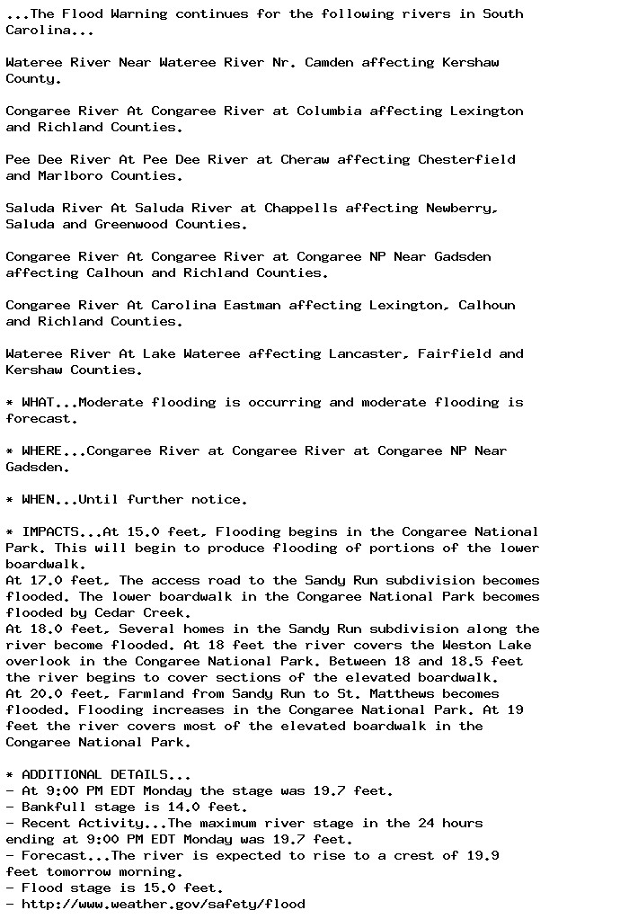
🚨 Flood Warning issued September 30 at 10:10PM EDT until October 2 at 7:08PM EDT by NWS Columbia SC 🚨 Additional Details Here.

...The Flood Warning continues for the following rivers in South
Carolina...

Wateree River Near Wateree River Nr. Camden affecting Kershaw
County.

Congaree River At Congaree River at Columbia affecting Lexington
and Richland Counties.

Pee Dee River At Pee Dee River at Cheraw affecting Chesterfield
and Marlboro Counties.

Saluda River At Saluda River at Chappells affecting Newberry,
Saluda and Greenwood Counties.

Congaree River At Congaree River at Congaree NP Near Gadsden
affecting Calhoun and Richland Counties.

Congaree River At Carolina Eastman affecting Lexington, Calhoun
and Richland Counties.

Wateree River At Lake Wateree affecting Lancaster, Fairfield and
Kershaw Counties.

* WHAT...Moderate flooding is occurring and moderate flooding is
forecast.

* WHERE...Congaree River at Congaree River at Columbia.

* WHEN...Until Wednesday evening.

* IMPACTS...At 10.0 feet, Flooding occurs in flood prone areas near
and downstream from Columbia. Flooding also occurs on parts of the
Cayce and West Columbia river walk.
At 13.0 feet, Flooding occurs in flood prone areas near and
downstream from Columbia. Flooding also occurs over much of the
Cayce and West Columbia river walk.
At 14.0 feet, Roads in low lying areas and swampland downstream
from Columbia become flooded. Most of the Cayce and West Columbia
river walk is flooded.
At 16.0 feet, Old State Road, SC 66, below Cayce becomes flooded.
At 19.0 feet, Extensive swampland and large areas of farmland and
pasture land downstream from Columbia become flooded.
At 21.0 feet, Extensive swampland and large areas of farmland and
pasture land downstream from Columbia are flooded.
At 24.0 feet, Flooding also occurs in the Cayce Quarry.
At 28.0 feet, Flooding begins in low lying areas of the Riverland
Park subdivision in Cayce.


* ADDITIONAL DETAILS...
- At 9:00 PM EDT Monday the stage was 29.0 feet and receding.
- Bankfull stage is 19.0 feet.
- Recent Activity...The maximum river stage in the 24 hours
ending at 9:00 PM EDT Monday was 30.6 feet.
- Forecast...The river is expected to fall below flood stage
tomorrow evening and continue falling to 7.9 feet Saturday
evening.
- Flood stage is 19.0 feet.
- http://www.weather.gov/safety/flood
0
AFtlh.nws-bot.us

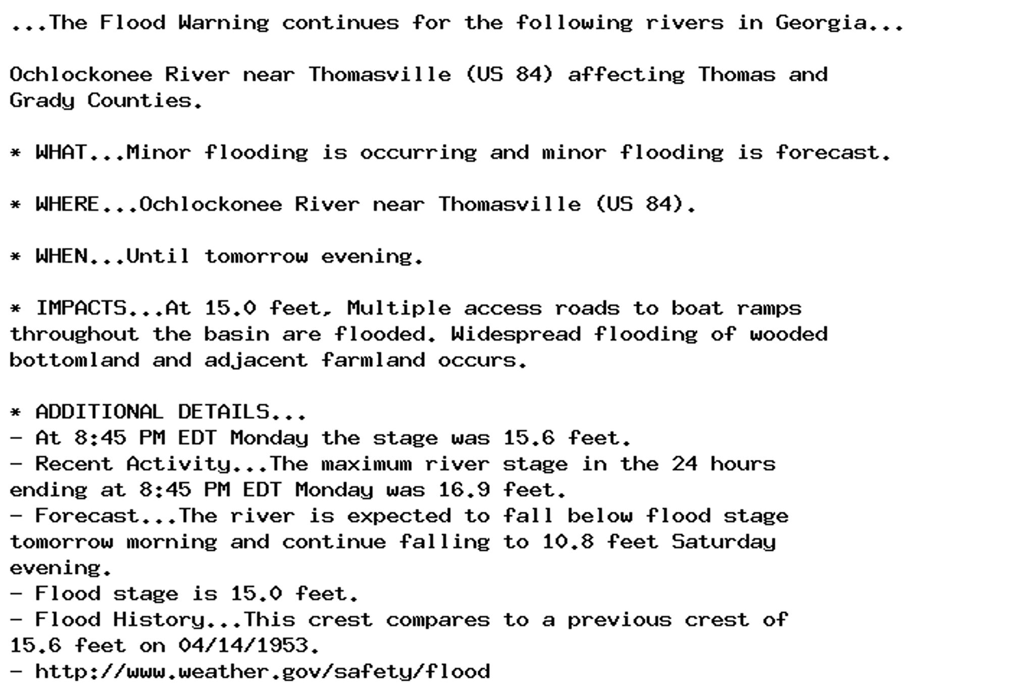
🚨 Flood Warning issued September 30 at 9:58PM EDT until October 1 at 8:00PM EDT by NWS Tallahassee FL 🚨 Additional Details Here.

...The Flood Warning continues for the following rivers in Georgia...

Ochlockonee River near Thomasville (US 84) affecting Thomas and
Grady Counties.

* WHAT...Minor flooding is occurring and minor flooding is forecast.

* WHERE...Ochlockonee River near Thomasville (US 84).

* WHEN...Until tomorrow evening.

* IMPACTS...At 15.0 feet, Multiple access roads to boat ramps
throughout the basin are flooded. Widespread flooding of wooded
bottomland and adjacent farmland occurs.

* ADDITIONAL DETAILS...
- At 8:45 PM EDT Monday the stage was 15.6 feet.
- Recent Activity...The maximum river stage in the 24 hours
ending at 8:45 PM EDT Monday was 16.9 feet.
- Forecast...The river is expected to fall below flood stage
tomorrow morning and continue falling to 10.8 feet Saturday
evening.
- Flood stage is 15.0 feet.
- Flood History...This crest compares to a previous crest of
15.6 feet on 04/14/1953.
- http://www.weather.gov/safety/flood
0