BLUE
STspc-storms.nws-bot.us

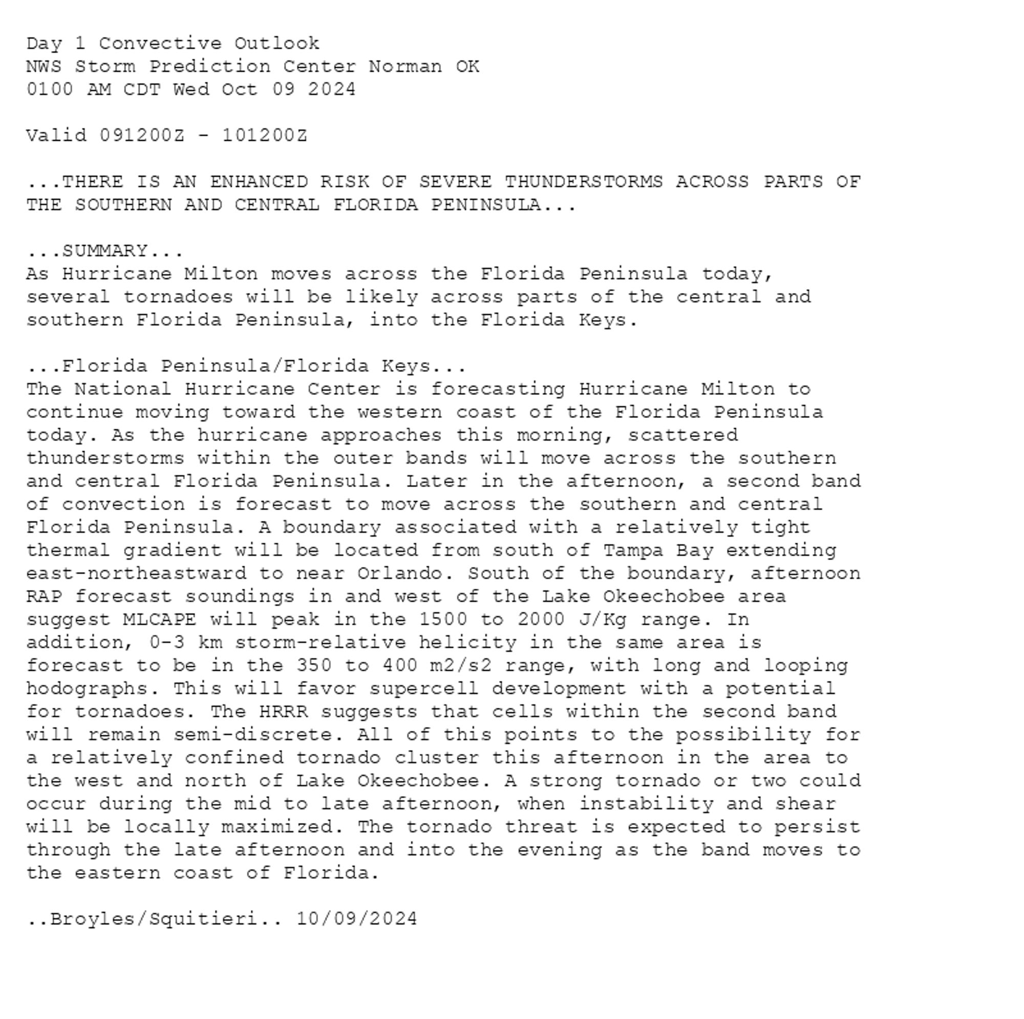
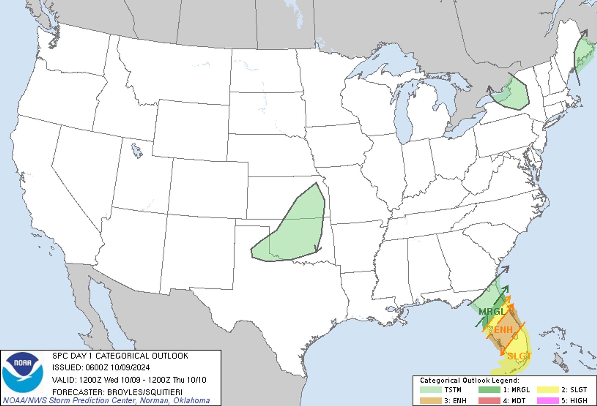
SPC Oct 9, 2024 0600 UTC Day 1 Convective Outlook ⛈️THERE IS AN ENHANCED RISK OF SEVERE THUNDERSTORMS ACROSS PARTS OF THE SOUTHERN AND CENTRAL FLORIDA PENINSULA🌪️ Additional Details Here.


Day 1 Convective Outlook  
NWS Storm Prediction Center Norman OK
0100 AM CDT Wed Oct 09 2024

Valid 091200Z - 101200Z

...THERE IS AN ENHANCED RISK OF SEVERE THUNDERSTORMS ACROSS PARTS OF
THE SOUTHERN AND CENTRAL FLORIDA PENINSULA...

...SUMMARY...
As Hurricane Milton moves across the Florida Peninsula today,
several tornadoes will be likely across parts of the central and
southern Florida Peninsula, into the Florida Keys.

...Florida Peninsula/Florida Keys...
The National Hurricane Center is forecasting Hurricane Milton to
continue moving toward the western coast of the Florida Peninsula
today. As the hurricane approaches this morning, scattered
thunderstorms within the outer bands will move across the southern
and central Florida Peninsula. Later in the afternoon, a second band
of convection is forecast to move across the southern and central
Florida Peninsula. A boundary associated with a relatively tight
thermal gradient will be located from south of Tampa Bay extending
east-northeastward to near Orlando. South of the boundary, afternoon
RAP forecast soundings in and west of the Lake Okeechobee area
suggest MLCAPE will peak in the 1500 to 2000 J/Kg range. In
addition, 0-3 km storm-relative helicity in the same area is
forecast to be in the 350 to 400 m2/s2 range, with long and looping
hodographs. This will favor supercell development with a potential
for tornadoes. The HRRR suggests that cells within the second band
will remain semi-discrete. All of this points to the possibility for
a relatively confined tornado cluster this afternoon in the area to
the west and north of Lake Okeechobee. A strong tornado or two could
occur during the mid to late afternoon, when instability and shear
will be locally maximized. The tornado threat is expected to persist
through the late afternoon and into the evening as the band moves to
the eastern coast of Florida.

..Broyles/Squitieri.. 10/09/2024
Day 1 Outlook Image
0
Kkkssaaiivv.bsky.social

Quero q todos os funcionarios da supercell morram

0
Kkennyqqqax.bsky.social

Cara o jogo e da Supercell, e ainda tá seguindo o mesmo caminho que os outros jogos, um jogo competitivo que tu vai ter que pagar pra consegui o mínimo que você precisa joga, e recentemente eles botaram o passe pago cara, tá uma merda

1
Rraphabr45.bsky.social

Vc nunca jogou clash royale? Aproveita e cria um supercell ID para vc n perder o seu progresso.

1
rhuy0kk.bsky.social

A hora que os artistas oficiais choram e a Supercell não vê, as artes estão tão melhores que as oficiais.

0
Jhcatshani.woke.cat

eu smp fico na expectativa de vim algum personagem de vdd mas NAO nn vem nem xp nem moeda e nem skin pra mim so vem ponto d poder q nem uso ja q jogo so com os msm 3 brawlers supercell ja foi mlhr (beemm no começo do jogo)

1
STspc-storms.nws-bot.us

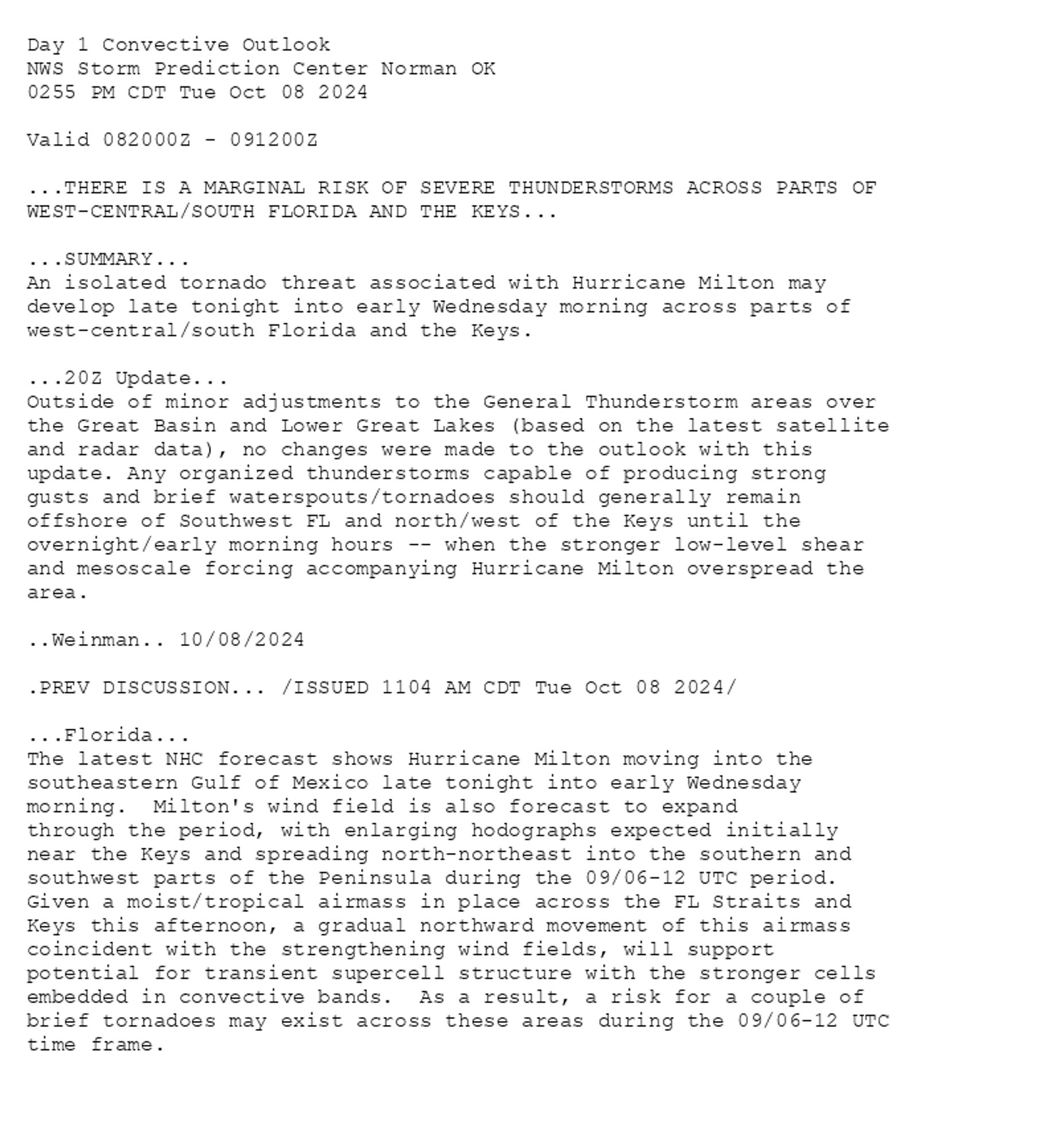
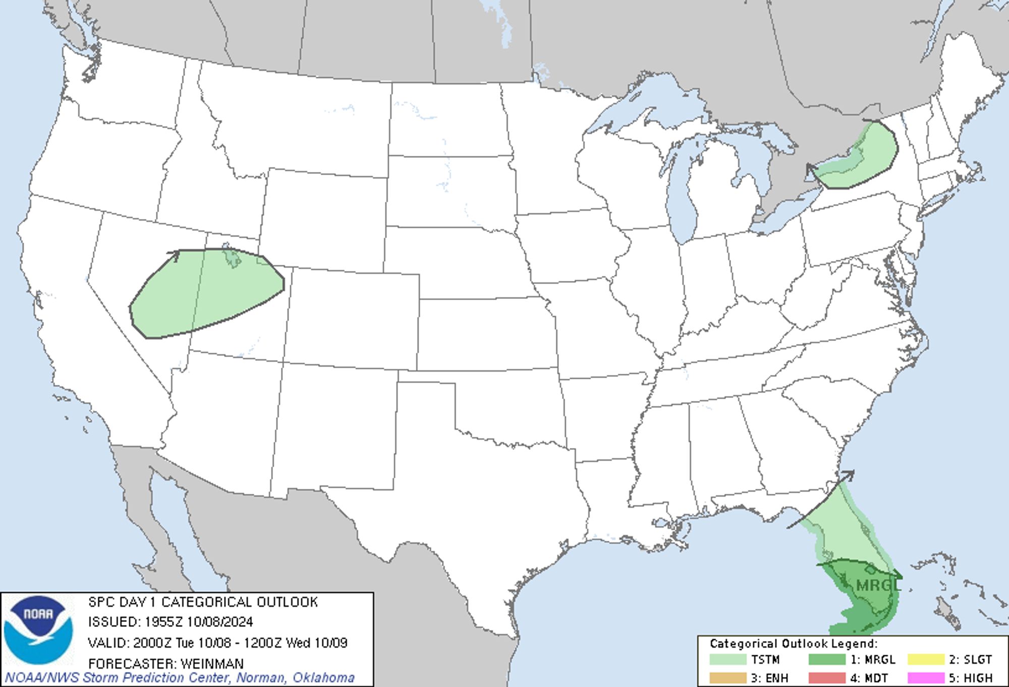
SPC Oct 8, 2024 2000 UTC Day 1 Convective Outlook ⛈️THERE IS A MARGINAL RISK OF SEVERE THUNDERSTORMS ACROSS PARTS OF WEST-CENTRAL/SOUTH FLORIDA AND THE KEYS🌪️ Additional Details Here.


Day 1 Convective Outlook  
NWS Storm Prediction Center Norman OK
0255 PM CDT Tue Oct 08 2024

Valid 082000Z - 091200Z

...THERE IS A MARGINAL RISK OF SEVERE THUNDERSTORMS ACROSS PARTS OF
WEST-CENTRAL/SOUTH FLORIDA AND THE KEYS...

...SUMMARY...
An isolated tornado threat associated with Hurricane Milton may
develop late tonight into early Wednesday morning across parts of
west-central/south Florida and the Keys.

...20Z Update...
Outside of minor adjustments to the General Thunderstorm areas over
the Great Basin and Lower Great Lakes (based on the latest satellite
and radar data), no changes were made to the outlook with this
update. Any organized thunderstorms capable of producing strong
gusts and brief waterspouts/tornadoes should generally remain
offshore of Southwest FL and north/west of the Keys until the
overnight/early morning hours -- when the stronger low-level shear
and mesoscale forcing accompanying Hurricane Milton overspread the
area.

..Weinman.. 10/08/2024

.PREV DISCUSSION... /ISSUED 1104 AM CDT Tue Oct 08 2024/

...Florida...
The latest NHC forecast shows Hurricane Milton moving into the
southeastern Gulf of Mexico late tonight into early Wednesday
morning.  Milton's wind field is also forecast to expand
through the period, with enlarging hodographs expected initially
near the Keys and spreading north-northeast into the southern and
southwest parts of the Peninsula during the 09/06-12 UTC period. 
Given a moist/tropical airmass in place across the FL Straits and
Keys this afternoon, a gradual northward movement of this airmass
coincident with the strengthening wind fields, will support
potential for transient supercell structure with the stronger cells
embedded in convective bands.  As a result, a risk for a couple of
brief tornadoes may exist across these areas during the 09/06-12 UTC
time frame.
Day 1 Outlook Image
0
O0ojota.bsky.social

Amigo desculpa mas acho que a supercell está pouco se fudendo pra quem compartilha conta, principalmente quem não tá jogando Nunca vi ninguém que realmente foi banido por isso

2
BSbrawlstarsbrasil.shop

Sorteio 1x Pacote de 30 Gemas! 🏆 O vencedor pode escolher via Supercell Store ou Gift Card. Requisitos: – Seguir @brawlstarsbrasil.bsky.social#BrawlStars#Giveaway

24
EFesqueletinho.user.pm

Literalmente a supercell matou o canhoneiro de vez com esse nerf adicional

1